Polarstern
PS119
Punta Arenas - Port Stanley 13 April 2019 - 31 May 2019
Coordinator: Rainer Knust
Chief Scientist: Gerhard Bohrmann
Alfred-Wegener-Institut Helmholtz-Zentrum
für Polar- und Meeresforschung Am Handelshafen 12
D-27570 Bremerhaven
Telefon: ++49 471 4831- 0 Telefax: ++49 471 4831 – 1149 E-Mail: info@awi.de
Website: http://www.awi.de
Email Coordinator: rainer.knust@awi.de Email Chief Scientist: gbohr mann@marum.de
PS119
13 April 2019 - 31 May 2019 Punta Arenas – Port Stanley
Chief Scientist Gerhard Bohrmann
Coordinator
Rainer Knust
CONTENTS
1. Überblick und Fahrtverlauf 2
Summary and Itinerary 4
2. SEEPS and Vents from Trench to the Back-arc of the South
Sandwich Plate – Fluid and Gas Circulation of the Microplate 5
3. Bathymetry and Sub-bottom Profiling 16
4. South Georgia and NE’Scotia Sea Sediment Sampling 18
5. Sediment Biogeochemistry 21
6. Large Whale Distribution around South Georgia and the South
Sandwich Islands in the Post-whaling Era 25
7. The Pelagic Ecosystem of the Scotia Sea and the Role of the amphipod Themisto gaudichaudii as Potential Climate-change
Winner (ThemPo) 27
8. SSIVOLC – Structural Analysis, Edifice Stability Assessment and the Investigation of Volcanic Processes at the Active Volcanoes
of the South Sandwich Islands 30
9. Teilnehmende Institute / Participating Institutions 34
10. Fahrtteilnehmer / Cruise Participants 37
11. Schiffsbesatzung / Ship's Crew 39
1. ÜBERBLICK UND FAHRTVERLAUF
Gerhard Bohrmann (MARUM)
Forschungsschiff Polarstern startet am 13. April 2019 zu seiner 119. Expedition, die das Schiff in die Subantarktis führt. Das Schiff wird von Punta Arenas (Chile) nach Osten durch die Magellanstrasse in den Südatlantik aufbrechen (Abb. 1.1). Nach circa 4-5 Tagen Transit wird Polarstern Südgeorgien erreichen, wo auf dem südlichen Schelf des Mikrokontinentes südlich der Paradise Bucht ein erster Tauchgang mit MARUM ROV QUEST zur sogenannten Paradise Flare Lokation geplant ist. Sedimentbeprobungen auf dem Schelf und in der südlich anschließenden Tiefseeregion ergänzen ein Stationsprogramm von ca. 1-2 Tagen.
Danach wird Polarstern das Hauptuntersuchungsgebiet der Sandwich-Inseln aufsuchen. Ziel der Arbeiten dort ist die multidisziplinäre Untersuchung von hydrothermalen und kalten Quellen mithilfe geophysikalischer und geologischer Methoden sowie visueller Meeres- bodenbeobachtungen und Probennahme. Neu zu entdeckende Austritte von Gas und Fluiden sollen geologisch und geochemisch charakterisiert werden. Bisher gibt es nur sehr wenige Hinweise auf Seeps und Vents entlang der Sandwich-Mikroplatte. Neu zu entdeckende Seeps und Vents sind von besonderem Interesse, da die Sandwich-Mikroplatte ein wichtiges Verbindungsglied zwischen dem Weltozean und der Antarktis darstellt, und damit gerade auch im Hinblick auf die Biogeographie von chemosynthetischen Lebens- gemeinschaften eine Schlüsselstellung einnimmt. Zudem nimmt die Sandwich-Mikroplatte eine besondere geologisch-geochemische Stellung ein, wegen ihrer Lage südlich der Polarfronten innerhalb des Opalgürtels einerseits und ihrer Tektonik mit einer Konvergenz- Zone zwischen zwei ozeanischen Platten andererseits. Bislang gibt es hydrothermale Quellen an den Segmenten E2 und E9 des östlichen Scotia Rückens, wohingegen kalte Quellen im Bereich des Fore-Arcs bisher nicht bekannt sind. In Analogie zu anderen konvergenten Plattengrenzen sind hier Fluidaustritte zu erwarten.
Wir planen Vermessungen in bisher unkartierten Bereichen des Back-Arcs zwischen den Sandwich-Inseln und dem bis zu 8.000 m tiefen Tiefseegraben mit dem Fächerecholot sowie mit dem Sedimentecholot. Dabei steht die Untersuchung von heißen und kalten Quellen im Mittelpunkt, wobei zahlreiche Tauchgänge mit ROV QUEST zur Untersuchung und Beprobung der Vent-Lokationen durchgeführt werden sollen. Sedimentbeprobungen mit Kolben- und Schwereloten, sowie Multicorer werden zur Beprobung von Seeps und paläozeanographische und sedimentgeologische Studien im Opalgürtel durchgeführt.
Untersuchungen der Wassersäule mittels CTD und Wasserschöpfern für mikrobiologische Fragestellungen und zur Detektion von Gasemissionen ergänzen das Programm, genauso wie Beprobungen des kieseligen Phyto- und Zooplanktons der Wassersäule im südlichen Antarktischen Zirkumpolarstrom. Visuelle Direktbeobachtungen und bathymetrische Vermessungen werden auch mit dem Tiefseefotoschlitten OFOB des AWI entlang von überstreichenden Bodenprofilen durchgeführt.
Die Erwärmung der Ozeane kann zu Verschiebungen von Verbreitungsmustern mariner Organismen führen, die bei fehlenden Grundlagenkenntnissen über Verbreitung und Populationskonnektivität unbemerkt bleiben und Folgen schwer zu prognostizieren sind.
Insbesondere im Scotiameer hat die Erwärmung des Oberflächenwassers zu Veränderungen von Abundanz und Verbreitung von zooplanktonischen Arten geführt. Eine polwärts verlaufende Ausdehnung der Verbreitungen einiger Crustaceenarten wird aufgrund geringer
thermaler Einschränkungen vorhergesagt, z.B. für die Art Themisto gaudichaudii. Das Projekt ThemPo bietet die Möglichkeit, die genetische und trophische Konnektivität diese wichtige Planktonart zu untersuchen, um Erkenntnisse über deren Anpassung und Verbreitung zu gewinnen.
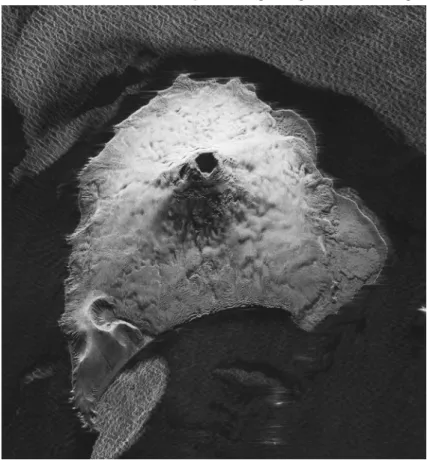
Parallel zu den marinen Untersuchungen sind Helikopterflüge zur quantitativen Erfassung von Großwalpopulationen geplant. Über 2 Millionen Großwale wurden zur Zeit des kommerziellen Walfangs in der Antarktis getötet und der Erholungszustand der Wale, vor allem der Finnwale ist bis heute wenig untersucht. Weiterhin sind vulkanologische Untersuchungen auf den Vulkanen der Süd-Sandwich Inseln geplant. Diese umfassen strukturgeologische Geländemessungen, Drohnenüberflüge und die Radarsatellitendaten- auswertung auf den beiden Inseln Saunders und Zavodovski. Beide Inseln beherbergen Vulkane, die rezente Ausbrüche erleben. Der Vulkan Mount Michael (Saunders) zeigt einen der weltweit seltenen, periodisch auftretenden Lavasee, der genauer untersucht werden soll.
Von den Süd-Sandwich Inseln aus sind die Falklandinseln in 4-5 Tagen zu erreichen, wo das Einlaufen von Polarstern am Freitag den 31. Mai in Port Stanley geplant ist.
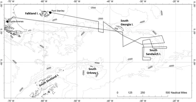
Abb. 1.1: Geplante Fahrtroute der Polarstern-Expedition PS119 Fig. 1.1: Planned cruise track during Polarstern expedition PS119
SUMMARY AND ITINERARY
The research ship Polarstern will depart on April 13, 2019 to its 119th expedition, which will lead the ship to the Sub-Antarctic (Fig. 1.1). The ship will leave Punta Arenas (Chile) through the Magellan street to the east into the South Atlantic. After approximately 4-5 days of transit, Polarstern will reach South Georgia, where we will conduct a first dive with Marum’s ROV QUEST to study the so-called Paradise flare situated on the south-eastern shelf of South Georgia. Sediment samples will be collected on this part of the shelf and in the deeper region south of it; work that will last for approximately 2 days.
Afterwards, Polarstern will continue to steam to the Sandwich Islands, which is the main study-area of the cruise. We aim to investigate hydrothermal vents and cold seeps using a multidisciplinary approach that includes geophysical and geological methods as well as visual sea-ground observations and sampling. New discoveries of gas and fluids will be characterized geochemically and geologically. Up to date, only a few seeps and vents were discovered along the Sandwich micro-plate. Therefore, detection of additional seeps and vents are of particular interest, as the Sandwich micro-plate presents an important link between the Atlantic and the Pacific especially in terms of the biogeography of chemosynthetic communities. In addition, the Sandwich micro-plate occupies a special geological-geochemical position, because the plate is located south of the polar fronts, within the biogenic opal belt, and the plate tectonics result from two converging oceanic plates. To date, there are hydrothermal sources on the E2 and E9 segments of the eastern Scotia Ridge, whereas cold seeps are not known in the fore-arc area. However, fluid outlets can be expected here, because fluid seep from similar convergent plate boundaries.
We plan hydroacoustic surveys of areas that have not been mapped before, which are the back-arc between the Sandwich Islands and the adjacent deep-sea trench reaching depths of 8,000 m, using multi-beam and single-beam echo-sounder. Our focus is to find and investigate hydrothermal vents and cold seeps, which will be studied and sampled by numerous dives with the ROV QUEST. Visual observations and bathymetric measurements will be also carried out with the deep-sea photo-sled OFOB provided by AWI moving along the seafloor by way of overlapping paths. Sediments will be collected with ROV QUEST, but also with multicorer, piston- and gravity corer. Apart from seep/vent sediments, sediments for paleo-oceanographic and sediment-geological studies of the biogenic silica belt will be taken.
Studies of the water column using CTD and water sampler for microbiological questions and for the detection of gas emissions complement the program, as well as sampling of siliceous phyto- and zooplankton living in the water of the Antarctic circumpolar current.
Ocean warming has the potential to induce major distributional shifts that will remain unnoticed without a solid baseline knowledge on distribution and population connectivity.
Particularly in the Atlantic sector of the Southern Ocean, warming waters have already led to distributional changes of zooplankton species. A scenario of poleward expansion is predicted for several crustacean species, e.g. the amphipod Themisto gaudichaudii, due to a lesser thermal constrain on spatial distribution. The project ThemPo will provide the opportunity to study the genetic and trophic connectivity of this key planktonic species in order to understandtheir adaptation and spreading potential.
Next to the marine investigations, helicopter flights are planned for the quantitative detection of whale populations. More than 2 million whales were killed at the time of commercial whaling in Antarctica and the recreational status of the whales, especially the fin whales, has
not been studied in detail until today. Furthermore, erosional and magmatic processes will be studied on the volcanoes of the South Sandwich Islands. These studies include structural geological terrain measurements, surveying flights with a drone, and satellite sonar-data- analysis on the two islands Saunders and Zavodovski. Both islands hold volcanoes that experienced recent eruptions. Moreover, Mount Michael volcano (Saunders) shows one of the world’s rare, periodically occurring lava lakes, which will be investigated in detail.
From the South Sandwich islands, Falkland islands can be reached in 4-5 days, where the Polarstern is scheduled to arrive on Friday 31st of May in Port Stanley.
2. SEEPS AND VENTS FROM TRENCH TO THE BACK-ARC OF THE SOUTH SANDWICH PLATE – FLUID AND GAS CIRCULATION OF THE MICROPLATE
G. Bohrmann, H. Büttner, A. Diehl, C Ferreira, J. Malnati, Y Marcon, T. Pape, S. Pereira, V.
Ratmeyer, M. Römer, T. Schade, M. Schröder, I Vejjzovic, P. Wintersteller, (MARUM), M.
Meschede (Uni Greifswald), M. Franke, B. Geier (MPI-Bremen), C. Chen (JAMSTEC), K.
Linse (BAS), A. Lichtschlag (NOC), C. Little (Leeds), M. Torres (OSU) Objectives
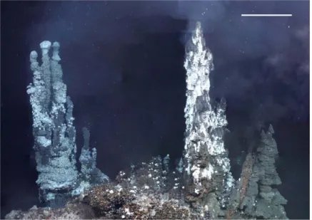
Geofuels are energy-rich fluids circulating through the seafloor that are modified and used by a variety of biota in, at, and above the seafloor. Black Smoker as seen in Fig. 2.1 are one of the most spectacular seafloor expressions of geofuel emission, with hot fluid venting (>300°C), minerals precipitating, and chemoautotrophic communities thriving on these fluids.
Fluid flow is induced either by hydrothermal circulations related to shallow magma chambers at seafloor spreading centers or by submarine volcanoes. The interaction between minerals and fluid at elevated temperatures within the hydrothermal circulatory system creates a geofuel augmented in energy-rich chemical compounds (sulfide, methane, hydrogen). In contrast to hot vents, fluids at cold seeps are cold and the flux is much smaller, however, they are hydrocarbon-rich providing the basis for carbonate precipitation and chemosynthetic life.
Cold seepage can be related to dewatering processes at convergent plate margin settings or various other geological processes that bring hydrocarbon-rich fluids to the seafloor.
Hydrothermal vents and cold seeps are ecological hot spots in the deep sea as an alternative food source (energy-rich chemical compounds) is utilized in an environment that is generally considered to be food-limited. As a consequence, luxuriant communities composed of highly adapted species occur at hot spots while those communities in the surrounding deep sea are generally meagre. One characteristic of hot spots is, that they are spatially very limited, which makes their discovery very difficult. However, more than three decades of research have provided evidence for many sites of hydrothermal venting (Fig. 2.2) as well as cold seepage (Sibuet and Olu, 1998) throughout the ocean. The distribution of these hot spot ecosystems is along corridors with hydrothermal vents being aligned along the hydrothermally active mid-ocean ridges. In contrast, vesicomyid clams, representing a typical family occurring at cold seeps, have distributed in several lineages multiple times along the global system of continental margins (Krylova and Sahling, 2010).
Fig. 2.1: Photo-mosaic of Black Smokers and chemosynthetic communities
at the East Scotia Ridge (ESR) (Rogers et al., 2012).
The vertical chimneys are covered by white yeti crab (Kiwa n. sp.) and the area between the chimneys is occupied by an undescribed brown peltospiroid gastropod.
We have identified the fore-arc and back-arc off the South Sandwich Islands as a key area to study processes related to fluid circulation for several reasons: (1) Cold and hot venting can be studied in relatively close proximity to each other at the Sandwich micro-plate. (2) The classical interoceanic subduction zone is located in the biogenic silica belt of the Southern Ocean, which has an impact on geochemical processes within the subduction zone and has potentially also influence on the chemical composition of the fluids circulating in the sediments and vents at the seafloor. This opposes most other convergent continental margins, which receive mainly terrigenous or calcareous sediments. (3) The interoceanic convergent margin is characterized by subduction erosion. It can be hypothesized that the tectonic control of fluid flow at this interoceanic plate margin is comparable to other well studied continental margins that are also characterized by subduction erosion. (4) The remoteness of the Sandwich micro-plate on the one hand and its location that links the Pacific and the Atlantic Ocean on the other hand makes the region a key area to study the biogeography of chemosynthetic communities.
Fig. 2.2: Global distribution of hydrothermal vent communities with different symbols representing typical
provinces resulting from multivariate statistics (Rogers et al., 2012). The recent discovery shows that the East
Scotia Ridge (blue dots) is a province of its own, which poses further question regarding the global distribution of these communities and
illustrates the yet unappreciated diversity of the system.
The Sandwich Arc and the Scotia Sea have been identified by the ChEss (Chemosynthetic Ecosystem Science), which is the field project of the Census of Marine Life Program (CoML), as a key area understanding biogeographic aspects of chemosynthetic communities (see Science on http://www.noc.soton.ac.uk/chess). At a global scale, differences between vent
biogeographic provinces largely reflect their degree of separation along the ridge system (Tunnicliffe & Fowler, 1996). At present, the only ridge-crest connection between the Atlantic and Pacific is via the Indian Ocean along the South-West, Central, and South-East Indian Ridge. However, the Sandwich arc could possibly provide a short cut between the Pacific and Atlantic for larvae that drift for a long time in the water column. The Sandwich arc together with the South-West Indian Ridge are, therefore, target areas for present and proposed research cruises to hydrothermal vents.
The overarching goal of the cruise is to increase our knowledge of fluid flow and its related processes in the area of the South Sandwich fore-arc and back-arc. The cruise will concentrate on exploratory work at hydrothermal vents and cold seeps using existing seismic data, multi-beam, and Parasound echosounder, hydrocasts as well as ROV-guided observations and sampling at the seafloor. The objective is to find and characterize sites at the seafloor influenced by fluid flow.
One specific goal of the cruise is to understand the role of fluid seepage in the South Sandwich fore-arc area, which is a classic intra-oceanic convergence zone characterised by subduction erosion (Vanneste and Larter, 2002a). We will test the hypothesis that the location of fluid flow at the seafloor is controlled by thermally-induced mineral dewatering processes at the plate boundary as has been observed at other convergent margins characterised by subduction erosion. Analogous to other settings, the fluids that are released at the plate boundary may be channelled through extensional faults in the upper plate and eventually reach the seafloor. Consequently, the exploration in the South Sandwich fore-arc will initially concentrate on the so-called “trench slope break” at about 4,500 m water depth, where normal faulting has been documented with deep-penetration multi-channel seismics. A combination of various mapping techniques will be used to systematically find fluid-flow influenced areas at the seafloor including multi-beam, Parasound echo-sounder, and ROV dives using MARUM ROV QUEST.
A further goal of the cruise is to investigate fluid circulation patterns in the area of known hydrothermal vent sites at the East Scotia Ridge in the back-arc basin off the Sandwich Islands. Following the finding of hydrothermal vents at the segments E2 and E9 by our British colleagues from NOCS and BAS (Rogers et al. 2012, Marsh et al. 2012) we are mostly interested in back-arc segments E2 and E5 and would like to complement the initial work at Kemp caldera. A further objective is to obtain a detailed insight into the composition of the chemosynthetic community as well as any occurring precipitates. Sampling of precipitates and the related pore water environment will allow characterizing the geochemical environment of seepage. Precipitates will be used as archives of seepage.
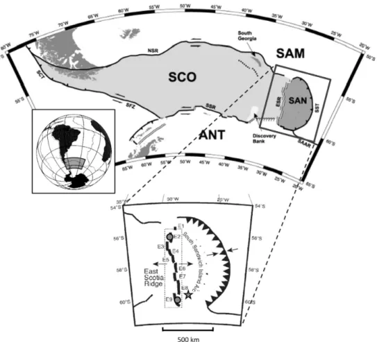
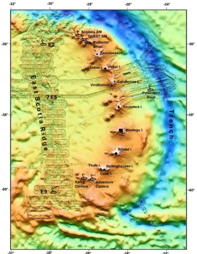
The East Scotia Ridge (Fig. 2.3) is located ca. 100-150 km west of the South Sandwich arc, which consists of 11 volcanic islands forming a 500-km-long distinctly curved island arc (Leat et al. 2003a). Most of the islands show evidence of recent volcanic activity and are entirely volcanic in origin. Although the location of rift segments of the East Scotia Ridge was documented by the magnetic anomalies and seismic profiles, the entire ridge was mapped in 1995 using the Hawaii-MR1 swath sonar, from which detailed bathymetry and backscatter information was processed (Livermore et al. 1997). The data clearly show 9 ridge segments, separated by non-transform offsets. Based on these findings the WNW-ESE-trending gravity anomalies in the west of the back-arc ridge are interpreted to represent the loci of migrating ridge offsets or pseudo-faults. Spreading rates of 60-70 mm/year place the East Scotia Ridge in the intermediate range of seafloor spreading centres, which is attributed to upwelling of the mantle and simultaneous cooling by the subducted slab. However, the morphology of the active centre varies from segment to segment and is transitional between a fast spreading centre with an axial high and slow spreading ridge with a median valley.
Along the South Sandwich Trench the South American Plate is subducting beneath the Sandwich Plate at a rate of 70-85 mm/year (Fig. 2.1). Earthquake data indicate that the subducting plate is dipping by an angle of 45-55° from east to west. The slab is probably steepening in the southern part of the subduction zone. The sedimentary cover of the oceanic crust consists of 200-400 m siliceous ooze of the Antarctic silica belt, which is a unique sediment type composed of more than 95 % of pure biogenic opal. The age of the southern part of the subducting crust is 28-35 Ma, whereas the crust subducting in the northern arc is much older (50-60 Ma). Multichannel seismic reflection lines that cross the South Sandwich trench (Fig. 2.3) and the island arc to the west were conducted in 1997 during the Sandwich Lithospheric and Crustal Experiment (SLICE; Larter et al. 1998). Those data together with detailed bathymetry and side-scan imagery gave first insights to how the crust is modified by the subduction processes, the tectonic fabric, and sedimentary features in the area of plate convergence (Vanneste et al. 2002a; Vanneste and Larter 2002b). The interpretation of the data together with the marine magnetic record of the seafloor spreading since 15 Ma has enabled quantitative estimation of sediment subduction and subduction erosion rates.
Fig. 2.3: Location of the East Scotia Ridge (ESR) and Kemp Caldera in the Scotia Sea, in relation to the South American plate (SAM), the Antarctic plate (ANT), the Scotia plate (SCO) and the Sandwich plate (SAN). ESR segments E1–E9 are labelled. Confirmed sites of hydrothermal activity are indicated
by grey circles (E2 and E9) and by the grey star at the base of the South Sandwich Island Arc (Kemp Caldera). SFZ: Shackleton Fracture Zone, NSR: North Scotia Ridge, SSR: South Scotia Ridge, SCT:
Southern Chile Trench, SST: South Sandwich Trench and SAAR: South American–Antarctic Ridge (from Cole et al. 2014).
Work at sea
In general, we follow the approach to conduct exploratory work during the cruise in order to identify and characterize seeps and vents at the seafloor of the East Scotia Ridge and seeps in the fore-arc area off the South Sandwich Islands. The two already discovered hydrothermal vent fields are located at the segments E2 and E9 (Rogers et al. 2012; Marsh et al. 2012) and we will concentrate our work at segments E2 and E5 and at Kemp caldera in the south. Methane seepage might be expected in two areas of the fore-arc. The first area is a potential mud volcano that has been identified in seismic data, the second area is the normally faulted “slope trench break”.
The following methods and tools will be deployed during the cruise:
• The MARUM ROV QUEST 4000 m will be the major tool for exploring the vent and seep sites. The ROV is a full sized, so-called "work class" deep-water ROV, originally designed to serve industrial needs for offshore production and intervention tasks. We will use the large payload capacity to provide a versatile platform for state-of-the-art deep-water science at water depths down to 4,000 m. Based on the weather conditions we think 20-25 dives are possible to conduct.
• A CTD with Niskin bottle rosette equipped with oxygen and turbidity sensors will be used for hydrocasts and water column profiling. The system will be employed in order to detect hydrothermal plumes and to study the methane concentration in the water column above methane seeps.
• The TV-sled OFOBS, which operates on a fiber-optic cable, is used for visual observation of the seafloor. The TV-sled is towed by the ship at speeds around 0.5 to 1 knot. It transmits video images online to the ship. In seep and vent areas, we will perform detailed profiles with underwater navigation of the sled. A specialty of the OFOBS is the bathymetry sidescan sonar EdgeTech 2205 with two sidescan frequencies (230kHz and 540 kHz) providing different ranges and resolutions.
• A conventional gravity corer (GC) and piston corer will be used to conduct sediment sampling in the vicinity of fluid seep sites and in the region of the opal belt.
• The ship-mounted ATLAS Parasound deep-sea single beam echo-sounder system will be used for water column imaging and sub-bottom profiling. The Parasound system is particularly useful for localizing bubble emission sites, which are hydroacoustically visible as flares, even in deep-sea environments.
• Hydrosweep multi-beam echo-sounder will be used for swath bathymetry mapping. In addition, the backscatter amplitudes will be extracted giving important information of the seafloor properties.
During the first half of the cruise, we plan to investigate segment E2 of the East Scotia Ridge and submarine volcanoes where hydrothermal venting has already been detected. CTD- profiling will be used to identify and confirm hydrothermal plumes and to detect their extent.
Video observations of the seafloor with OFOBS is intended for detailed bathymetric and chemosynthetic community mapping of the vent sites. . The second half of the cruise will be used to search for seeps in the South Sandwich fore-arc. There are presently two target areas with high potential for active fluid seepage, the mud volcano-like feature in the fore-arc basin ESE of Saunders Island and the “trench slope break” marked by “TSB” in Fig. 2.4. In both areas, Parasound echo-sounder surveys will be conducted that are used for sub- surface sediment imagery and for the search of gas bubble-induced hydro-acoustic anomalies in the water column. In order to gain a detailed insight into the shallow subsurface
structure, we plan to do two overview profiles along and across slope as well as about five shorter surveys that cross perpendicular the 25 nm wide area of the trench slope break. At least three OFOBS deployments should be conducted to search at the seafloor for evidence of fluid flow where seismic data indicate the presence of gas. In addition, gravity corer and piston corer will be deployed to reveal the presence or absence of gas- or gas hydrate-rich sediments complementing the bathymetric and visual mapping. A similar work schedule with comparable time requirements is requested for the potential mud volcano-like feature in the fore-arc basin.
Preliminary results
Preliminary results have been acquired during several cruises form our British colleagues from BAS and NOC, mostly in the South Sandwich Back-Arc area and along the Islands.
Some preliminary results have been taken during Polarstern cruise ANT-XXiX/4 (Bohrmann et al. 2013)
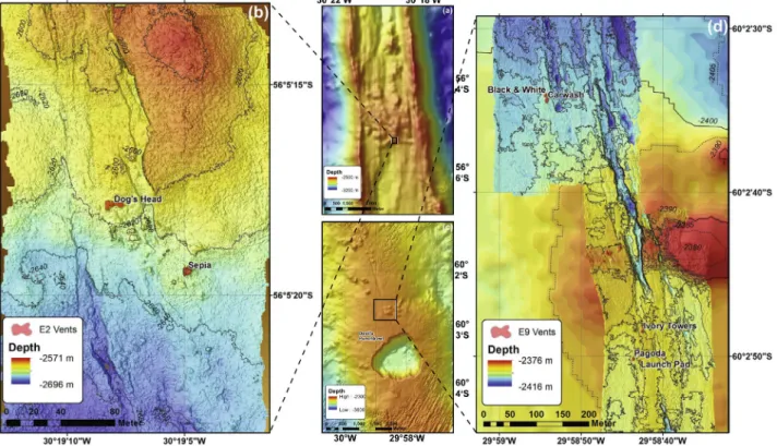
Fig. 2.4: Bathymetric maps of parts of the E2 and E9 segments of the East Scotia Ridge (middle) and two detailed micro-bathymetry maps (left and right) of vent areas. The multibeam micro-bathymetry maps were
recorded during RRS James Cook Cruise 42 on ROV ISIS (by James et al. 2014).
East Scotia back-arc ridge (ESR) and hydrothermal venting
Nine ridge segments separated by non-transform offsets were identified at the East Scotia Ridge (ESR) by mapping magnetic anomalies and seismic profiles (e.g. Barker 1995) and in the bathymetry and backscatter information derived from HawaiII-MR1 sidescan sonar mapping in 1995 (Livermore et al. 1995). Spreading rates of 60-70 mm/year place the East
Scotia Ridge in the intermediate range of seafloor spreading centres, which is attributed to upwelling of the mantle cooled by the subducted slab. However, the morphology of the active centre varies from segment to segment and is transitional between a fast spreading centre with an axial high and a slow spreading ridge with a median valley. Segments E3-E8 show faulted median valleys and the two segments in the north (Segment E2) and south (Segment E9) are characterised by an axial ridge and are propagating into the back-arc region (Livermore et al. 1997; Harrison et al. 2003). Segment E1 extends northward into the nearly W-E trending part of the South Sandwich trench. A southernmost Segment E10 is anomalous being situated on the southern margin of the Sandwich Plate. Along the ridge axis, there is a distinct trend in the axial depth, from maxima of more than 4.000 m in Segments E5 and E6 to minima of 2.600 m in the Segments 2 and 9. These morphological characteristics have provided arguments for models involving the shallow inflow of Atlantic mantle around the ends of the subducting slab (Livermore et al. 1997).
The presence of an axial magma chamber reflector underlying the axial volcanic ridge on segment E2 (Livermore et al., 1997) and the evidence for the presence of small pockets of magma remaining from a recent to sub-recent eruption event beneath E9 (Bruguier and Livermore, 2001) have made these seafloor segments the target of investigations for hydrothermal activity. Water column investigations revealed first evidence of hydrothermal activity along the two segments of the back-arc ridge. Using a combination of in-situ optical light–scattering sensor data and the dissolved manganese concentrations, hydrothermal plumes were detected in segments E2 and E9 (German et al. 2000). In the frame of the British NERC-founded program CHESSO (Chemosynthetically-driven Ecosystems South of the Polar Front Consortium), hydrothermal systems were visually detected using a camera sled (SHRIMP) and by ROV ISIS at the segments E2 and E9 (Fig. 2.4). Distinct two venting areas named Dog’s head and Sepia were surveyed in the segments E2 and five vent fields named Black and White, Carwash, Ivory Towers, Pagoda and Launch Pad were investigated in segment E9 (Fig. 2.4). Initial sampling has been conducted at these sites located at E2 and E9 as described in Rogers et al. (2012). Additional sampling was performed during the cruise No 88 of the James Cook in Dec-Jan 2012/2013. According to the information provided by our British colleagues, the cruise with ROV ISIS was focused on more intensive sampling of the known vent sites with additional exploratory work. Based on the initial results, the vents are dominantly inhabited by a new yeti crab (Kiwa n. sp.), stalked barnacles, limpets, peltospiroid gastropods, anemones, and a predatory sea star. This composition is largely different from known hydrothermal vent communities; noteworthy is the absence of siboglinid polycheats, bathymodiolid mussels, and alvinocarid shrimps. In recently published articles, our British colleagues report the chemical and isotopic composition of high- and low- temperature vent fluids, which are highly variable between the ridge segments (James et al.
2014). Fluid temperatures were ~350°C at all vent sites except Black and White location (Fig.
2.4), which was significantly hotter (383°C). End-member chloride concentrations in E2 fluids were close to seawater (540 mM), whereas Cl in E9 fluids was much lower (98-220 mM) indicating phase separation. Further chemical investigations show that, although both ridge segments are magmatically inflated, there is no compelling evidence for input of magmatic gases to the vent fluids (James et al. 2014). Based on the REE pattern in fluids and the basaltic to andesitic rocks, Cole et al. (2014) show the variable influence by ion exchange with host minerals, phase separation, competitive complexation with ligands, and anhydrite deposition.
South Sandwich Island Arc (SSIA) and hydrothermal activity
The South Sandwich arc is located about 100-150 km east of the East Scotia back-arc ridge and consists of 11 volcanic islands forming a 500-km-long distinctly curved island arc (Leat et al. 2003a). Most of the islands show evidence of recent volcanic activity and are entirely volcanic in origin. The volcanic rocks belong to the tholeiitic and calc-alkaline series, and the arc is regarded as a classic example of the primitive stages of Island arc developments (Pearce et al. 1995). Based on their detailed chemistry the arc magmas are thought to be derived from mantle wedge material that had experienced melt extraction before the magma generation events. Pearce et al. (1985) postulated that variations in incompatible trace elements are a result from dynamic melting processes within the sub-arc mantle and the volcanic rocks indicate the involvement of a subduction component derived from the subducted sediments and altered crust. Back-arc volcanic rocks are also at least locally influenced by the sediment-derived constituents (Fretzdorff et al. 2003).
Fig. 2.5: Bathymetry of the northernmost area of the South Sandwich Arc shows
a couple of submarine volcanoes
that have been investigated for hydrothermal activity
during Polarstern cruise ANT-XXIX/4 in
2013. (Bohrmann et al. 2013)
Extensive multibeam mapping of the submarine island arc area (Fig. 2.5) revealed the existence of several submarine volcanoes, some of them showing signs of relatively recent volcanic activity in the form of a morphologically well expressed caldera (Leat et al. 2010;
2014). Two features, Kemp Caldera and Adventure Caldera have been surveyed by video sled (SHRIMP) and CTD casts during the James Cook cruise 55 and showed clear signs for warm temperature venting < 28°C (Cole et al. 2014). Extensive fields of vesicomyid clams were observed and sampled with ROV ISIS at Kemp Caldera (pers. com. Katrin Linse). The fact that the faunal community at the island arc setting (vesicomyid clams) differs from that of the ESR (yeti crab, staked barnacles, peltospiroid gastropods) indicate that the underlying geofuel system is different.
Fig. 2.6: Bathymetric map of the QUEST caldera with TV-sled dives and temperature anomalies in
the caldera (Bohrmann et al. 2013).
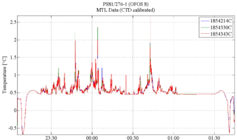
Fig. 2.7: Temperature anomalies within the water column close to the seafloor in the QUEST caldera recorded during Polarstern ANT-XXIX/4 (Bohrmann et al. 2013).
During Polarstern cruise ANT-XXIX/4 in 2013 three submarine volcanoes in the northern part of the South Sandwich Islands have been investigated to find further indications of hydrothermal activity. All three volcanoes QUEST SM, Protector Shoal and Scorsby SM (Fig.
2.5) showed hydrothermal activities indicated by temperature anomalies between 1-3°C (Fig.
2.6 and 2.7) measured in the water column by MTLs (Miniaturized Temperature data-Logger) and by chimney structures, which were observed by the Ocean Floor Observation System (OFOS; Bohrmann et al. 2013). Chemosynthetic fauna was not observed, but this might be mainly due to technical issues limiting the the use of the OFOS. High-temperature chemosynthetic communities, if they exist, may be concentrated in certain small areas, which we intent to explored with ROV Quest. Comparisons of the fauna and fluids of the hydrothermal manifestations at the Kemp and Adventure Calderas in the southern South Sandwich Island arc are particular of interest, because of the different setting.
The Scotia fore-arc area and potential seep sites
Along the South Sandwich Trench the South American Plate is subducting beneath the Sandwich Plate at a rate of 70-85 mm/year (Pelayo and Wiens, 1989). Earthquake data indicate that the subducting plate is dipping by an angle of 45-55° from east to west. The slab is probably steepening in the southern part of the subduction zone. The sedimentary cover of the oceanic crust consists of 200-400 m siliceous ooze of the Antarctic silica belt, which is a unique sediment type composed of more than 95 % of pure biogenic opal (Bohrmann et al.
1994). The age of the southern part of the subducting crust is 28-35 Ma, whereas the crust subducting in the northern arc is much older (50-60 Ma).
Multichannel seismic reflection lines that cross the South Sandwich trench and the Island arc to the West have been conducted in 1997 during the Sandwich Lithospheric and Crustal Experiment (SLICE; Larter et al. 1998). Those data together with detailed bathymetry and side-scan imagery gave first insights how the crust is modified by the subduction processes and the tectonic fabric and sedimentary features in the area of plate convergence (Vanneste et al. 2002; Vanneste and Larter 2002; Leat et al. 2003). The interpretation of the data together with the marine magnetic record of the seafloor spreading since 15 Ma enabled quantitative estimation of sediment subduction and subduction erosion rates.
Any accretionary wedge present is constrained to be very small extending less than 6 km from the trench. More than 95% of the sediment, which had entered since 15 Ma, has been subducted and the island arc migrated ca. 70 km to the west. The average rate of fore-arc retreat during that time interval is inferred to be 3.1-4.7 mm/year. At the present convergence rate of 74 mm/year this erosion rate requires a 420-635 m thick layer of subducting material derived from the fore-arc crust (Vanneste and Larter 2002). Since the frontal erosion can only account for less than 40% of the total subduction erosion, the basal erosion must significantly exceed the frontal erosion. The new data also provide insight into the fore-arc strain regime and the fore-arc basin evolution. Extensional faulting near the trench slope break was observed and is interpreted to be caused by gravitational instability of the lower slope. The seismic profiles over the fore-arc basin suggest that the balance between sediment deposition and erosion is sensitive to change in the elevation of the trench slope break. It was postulated by Vanneste and Larter (2002) that the basin is a dynamic feature, which goes through repeated cycles of growth and destruction controlled by cyclic uplift and collapse of the trench slope break.
The subduction erosion, characterizing the inter-oceanic convergent margin of the Scotia micro-plate, is a process that has been considerably well studied at the convergent continental margin setting offshore Costa Rica and southern Nicaragua. Despite the large differences between an oceanic-oceanic versus oceanic-continental type of collision zone it might be postulated that comparable tectonic processes control the hydrological cycle of both types of convergence zones. Basal as well as frontal erosion leads to ongoing shortening and thinning of the overriding continental margin offshore Costa Rica and Nicaragua (Ranero et al., 2008). As a result, the slope apron is dissected by extensional faults through which deep fluids are channelled. The fluids originate from mineral dewatering processes at the plate boundary that occurs at temperatures of about 80 to 150 °C (Hensen et al., 2004).
About 120 seep sites have been found along mid slope depth at the ~480 km long continental margin offshore Costa Rica and southern Nicaragua that has been systematically surveyed (Sahling et al., 2008). The seeps occur along a band at mid-slope depth that mirrors the temperature distribution at the plate boundary. They are located above the 80 to 150 °C isotherms at the plate boundary. Therefore, it can be speculated that seeps may be found at the extensional faults that have been imaged at the trench slope break at the Sandwich fore-arc by seismic methods. These faults may also channel fluids from greater depth that contain significant amounts of methane fuelling chemotrophic life at the seafloor.
The area was investigated during the RV Polarstern cruise ANT XXIX/4 (22 March – 16 April 2013) with the expectation to find evidence for cold seeps. During 2 days ship time, a cold seep was pre-investigated in the 3,000 – 4,000 m deep fore-arc basin east of Saunders and Candlemas Islands; the seep site was found by a distinct acoustic anomaly in the water column (Bohrmann et al. 2013). ROV- surveys are needed in order to understand the seep system in detail.
Data management
The following measures will be taken to promote scientific exchange and guarantee long- term data storage: During the cruise, all data will be made available for all scientists, either as raw or analysed data. A comprehensive cruise report will be written for thorough description of the acquired data and their preliminary interpretation. After the cruise, data analyses and interpretation will lead to scientific publications to present the findings to the scientific community. Part of the raw data will be made available to the public along with the publication either directly as, e.g. electronic appendix or indirectly by submitting the original data to Pangaea world data center.
The proponents are currently involved in a discussion about long term data storage of heterogeneous and large-size data sets. While it is good practice already to submit raw multibeam data to the Bundesamt für Seeschifffahrt und Hydrographie (BSH) there is no platform to store processed multi-beam data so far. Therefore, . original data of Parasound echo-sounder will be preliminary stored as data bundle in Pangaea. As soon as a solution has been developed to standardize the submission of processed echo-sounder data, we will convert the data accordingly and re-submit it to Pangaea. Furthermore, at present, there is no platform to archive videos collected by camera-guided tools for long term data storage.
The data are archived in house and available for everyone upon request. However, a discussion of how to archive these data is currently taking place.
References
Barker PF (1995) Tectonic framework of the East Scotia Sea. Backarc basins: Tectonics and magnetism. B. Taylor, New York, Plenum Press, 281-314.
Bohrmann G with contributions of the participants (2013) The expedition of the research vessel Polarstern to the Antarctic in 2013 (ANT-XXIX/4). Berichte zur Polar- und Meeresforschung
“Expedition Reports”, 668,Alfred Wegener Institute for Polar and Marine Research, Bremerhaven, hdl:10013/epic.41984
Bohrmann G, Abelmann A, Gersonde R, Hubberten H, Kuhn G (1994) Pure siliceous ooze, a diagenetic environment for early chert formation. Geology, 22, 207-210.
Bruguier NJ, Livermore RA (2001) Enhanced magma supply at the southern East Scotia Ridge:
Evidence for mantle flow around the subducting slab? Earth and Planetary Science Letters, 191, 129-144.
Cole CS, James RH, Connelly DP, Hathorne EC (2014) Rare earth elements as indicators of hydrothermal processes within the East Scotia subduction zone system. Geochimica et Cosmochimica Acta, 140, 20-38.
Fretzdorff S, Haase KM, Leat PT, Livermore RA, Grabe-Schönberg C-D, Fietzke J, Stoffers P (2003) 230Th-238U disequilibrium in East Scotia backarc basalts: Implications for slab contributions.
Geology, 31 (8), 693-696.
German CR, Livermore RA, Baker ET, Bruguier NI, Connelly DP, Cunningham AP, Morris P, Rouse IP, Statham PJ, Tyler PA (2000) Hydrothermal plumes above the East Scotia Ridge: an isolated high-latitude back-arc spreading centre. Earth and Planetary Science Letters, 184, 241-250.
Harrison D, Leat PT, Burnard P, Turner G, Fretzdorff S, Millar I (2003) Resolving mantle components in oceanic lavas from segment E2 of the East Scotia back-arc ridge, South Sandwich Islands.
Geological Society, London, Special Publications, 219, 333-344.
Hensen C, Wallmann K (2004) Fluid expulsion related to mud extrusion of Costa Rica – A window to the subducting slab. Geology, 32 (3), 201-204.
James RH, Green DRH, Stock MJ, Alker BJ, Banerjee NR, Cole C, German CR, Huvenne VAI, Powell AM, Connelly DP (2014) Composition of hydrothermal fluids and mineralogy of associated chimney material on the East Scotia Ridge back-arc spreading centre. Geochimica et Cosmochimica Acta, 139, 47-71
Krylova EM, Sahling H (2010) Vesicomyidea (Bivalvia): Current taxonomy and distribution. PLoS ONE, 5 (4), DOI:10.1371/journal.pone.0009957.
Larter RD, King EC, Leat PT, Reading AM, Smellie JL, Smythe DK (1998) South Sandwich slices reveal much about arc structure, geodynamics, and composition. EOS, 79, 281-285.
Leat PT, Fretwell PT, Tate AJ, Larter RD, Martin TJ, Smellie JL, Jokat W, Bohrmann G (2014) Bathymetry and geological setting of the South Sandwich Islands volcanic arc (various scales), BAS GEOMAP 2 Series (Sheet 6) British Antarctic Survey, Cambridge, UK.
Leat PT, Tate AJ, Tappin DR, Day SJ, Owen MJ (2010) Growth and mass wasting of volcanic centers in the northern South Sandwich arc, South Atlantic, revealed by new multibeam mapping. Marine Geology, 275 (1-4), 110-126.
Leat PT, Larter RD (2003a) Intra-oceanic subduction systems: introduction. Geological Society, London, Special Publications, 219, 1-17.
Livermore R, Cunningham A., Vanneste L, Larter R (1997) Subduction influence on magma supply at the East Scotia Ridge. Earth and Planetary Science Letters, 150, 261-275.
Livermore RA, Larter RD, Cunningham AD, Vanneste L, Hunter RJ and the JR09 team (1995) Hawaii- MR1 sonar survey of the East Scotia Ridge. BRIDGE Newsletter, 8, 51-53.
Marsh L, Colpley J, Huevennne VAL, Linse K, Reid WDK, Rogers AD, Sweeting CJ, Tyler PA (2012) Microdistribution of faunal assemblages at deep-sea hydrothermal vents in the Southern Ocean.
PLoS ONE, 7 (10), e48348.
Pearce JA, Leat PT et al. (1995) Geochemical evidence for mantle dynamics and mantle melting beneath the Scotia Sea and surrounding region. EOS, Transactions, American Geophysical Union, 76 (46), Fall Meeting Supplement, F542.
Pearce JA, Johannes RE, Manning CR, Rimmer DW, Smith DF (1985) Hydrology and nutrient data off Marmion, Perth, 1979-1982. CSIRO Marine Laboratories Report, 167, 45pp.
Pelayo AM, Wiens DA (1989) Seismotectonics and relative plate motions in the Scotia Sea region.
Journal of Geophysical Research, 94, 7293-7320.
Ranero CR, Grevemeyer I, Sahling H, Brackhausen U, Hensen C, Wallmann K, Weinrebe W, Vannucchi P, Von Huene R, McIntosh K (2008) The hydrological system of erosional convergent margins and its influence on tectonics and interpolate seismogenesis. Geochemistry Geophysics Geosystems, 9 (3).
Rogers AD, Tyler PA, Connelly DP, Copley JT, James R, Larter RD, Linse K, Mills RA, Garabato A-N, Pancost RD, Pearce DA, Polunin NVC, German CR, Shank T, Boersch-Supan PH, Alker BJ, Aquilina A, Bennett SA, Clarke A, Dinley RJJ, Graham AGC, Green DRH, Hawkes JA, Hepburn L, Hilario A, Huvenne VAI, Marsh L, Ramirez-Llodra E, Reid WDK, Roterman CN, Sweeting CJ, Thatje S, Zwirglmaier K (2012) The discovery of new deep-sea hydrothermal vent communities in the Southern Ocean and implications for biogeography. PLoS Biology, 10, e1001234.
Sahling H, Masson DG, Ranero CR, Hühnerbach V, Weinrebe W, Klaucke I, Bürk D, Brückmann W, Suess E. (2008) Fluid seepage at the continental margin offshore Costa Rica and southern Nicaragua. Geochemistry Geophysics Geosystems, 9 (5).
Sibuet M, Olu K (1998) Biogeography, biodiversity and fluid dependence of deep-sea cold-seep communities at ctive and passive margins. Deep-Sea Research II, 45, 517-567.
Tunnicliffe V, Fowler CMR (1996) Influence of sea-floor spreading on the global hydrothermal vent fauna. Nature, 379, 531-533.
Vanneste LE, Larter RD, Smythe DK (2002a) Slice of intraoceanic arc: Insights from the first multichannel seismic reflection profile across the South Sandwich island arc. Geology, 30 (9), 819- 822.
Vanneste LE, Larter RD (2002b) Sediment subduction, subduction erosion and strain regime in the northern South Sandwich forearc. Journal of Geophysical Research, 107 (B7), 2149.
3. BATHYMETRY AND SUB-BOTTOM PROFILING
G. Bohrmann, P. Wintersteller, C Ferreira, M. Römer, (MARUM), M. Meschede (Uni Greifswald), G. Kuhn (AWI), P. Leat (BAS)
Objectives
Accurate knowledge of the seafloor topography, that is high-resolution multibeam swath bathymetry data, provide essential information to understand geological processes in the area of the South-Sandwich plate. For multidisciplinary studies of seeps and vents in the
research area, bathymetry and micro-bathymetry data reveal the geomorphology of the seafloor. Potential venting locations can be identified by combining data on seafloor topography collected with swath bathymetry systems with information about sub-seafloor composition and stratigraphy derived from acoustic sub-bottom profiling. Basement rocks or older lithified sediments can be distinguished from soft sediment deposits. Seabed topography and seafloor substrate are key environmental parameters for benthic ecosystems, and consequently their characterization will allow for habitat classifications.
Overall, hydro-acoustic data provide fundamental information for site selection for the scientific working groups onboard.
Work at sea
The main task of the bathymetry and sub-bottom profiling group is to plan and run surveys using the Atlas Hydrosweep DS3 systems and the Parasound single-beam echo-sounder in the study area and during transit to provide information for station planning and to fill-up gaps in the bathymetric coverage (Fig. 3.1). The raw bathymetric data will be corrected for sound velocity changes in the water column and further processed for erroneous soundings and artefacts on board. Detailed seabed maps derived from the bathymetric data will provide information on the general and local topographic setting of target areas. Micro-bathymetry of specific areas will be processed from OFOBS-surveys, which are planned in areas of diving prior to the ROV dive. The new towed system OFOBS developed by AWI (Purser et al. 2018) is providing bathymetry and side scan sonar data together with high-resolution video and still photo imagery.
Fig. 3.1: Available bathymetry in the back-arc, arc, and fore-arc of the South Sandwich micro-plate (Leat et al. 2016)
Expected results
Expected results will consist of high-resolution seabed maps along the cruise track and from the target research sites. The bathymetric and backscatter data will be analyzed to provide geomorphological information of the research area. Expected outcomes aim towards a better understanding of the geological and, particularly, the venting processes in the research area and will be important as a pre-site survey for the ROV dives.
Data management
The sonar data collected during the expedition will be stored in the PANGAEA data repository at the AWI. Furthermore, the data will be provided to mapping projects and included in regional data compilations such as IBCAO (International Bathymetric Chart of the Arctic Ocean) and GEBCO (General Bathymetric Chart of the Ocean). Bathymetric data will also be provided to the Nippon Foundation – GEBCO Seabed 2030 Project.
References
Leat PT, Fretwell PT, Tate AJ, Larter RD, Martin TJ, Smellie JL, Jokat W, Bohrmann G (2016) Bathymetry and geological setting of the South Sandwich Islands volcanic arc. Antarctic Science, 1-11, DOI:10.1017/S0954102016000043
Purser A, Marcon Y, Dreutter S, Sablotney B, Hehemann L, Lemburg J, Dorschel B, Biebow H, Boetius, A (2018) Ocean Floor Observation and Bathymetry System (OFOBS): A new Towed Camera/Sonar System for Deep-Sea Habitat Surveys. IEEE Journal of Oceanic Engineering, DOI:10.1109/JOE.2018.2794095
4. SOUTH GEORGIA AND NE’SCOTIA SEA SEDIMENT SAMPLING
G. Kuhn (AWI), N. Lensch (AWI), N. Wöhltjen (AWI), M. Arevalo (AWI), T. v. Dobeneck (not on board), A. Graham (not on board)
Objectives
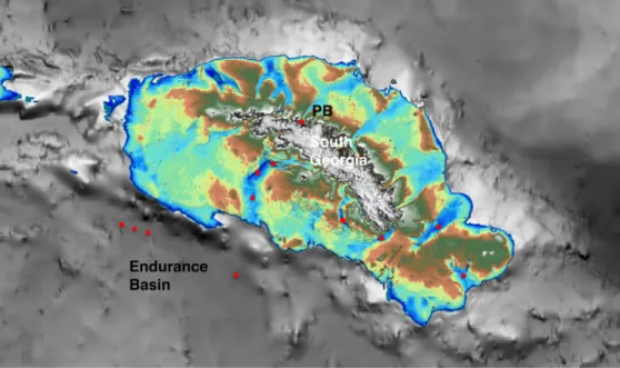
The flow of the Antarctic Circumpolar Current (ACC), related oceanographic frontal systems, and bathymetrically controlled outflow regions of AABW make the Scotia Sea an area of particular interest for surface- and bottom water paleoceanographic reconstructions. We aim to study the dynamic and spatial variability of these frontal systems during the last orbital climate cycle (last glacial cycle – 125,000 years to present). Near shore on the continental shelf, the extent of inland ice caps and glacial-marine sediments deposited by these glacier systems after their deglaciation can be mapped by multibeam swath and sub-bottom echo- sounding. High sediment accumulation in some fjords and coastal channels supply archives of recent glacier behaviour and climate changes. The South Georgia ice cap is more sensitive to climatic changes than the much larger and more isolated Antarctic ice sheets and, therefore, a prime target for better understanding Southern Hemisphere climate variability (Graham et al., 2008 and 2017).
During cruises ANT-X/5 (Gersonde, 1993), ANT-XI/2 (Gersonde, 1995), ANT-XXII/4 (Schenke and Zenk, 2005), ANT-XXIX/4 (PS81, Bohrmann et al., 2013) with Polarstern in 1992, 1993/94, 2005, and 2013, a cruise with Meteor M134 (Bohrmann, 2017), and cruises JR224, JR244 and JR257 with James Clark Ross in 2009, 2011, and 2012, respectively, MARUM, AWI, and BAS collected marine geological and geophysical data sets from the Scotia Sea and from the South Georgia (SG) shelf. Extensive paleo-ice sheet drainage on
highlighted in bathymetric compilations by Graham et al. (2008 and 2017). During this cruise, we will aim to complete the mapping of poorly documented drainage sectors and collect new and longer sediment cores and sediment surface samples in order to study and process them in regards to their sedimentological, geochemical, magnetic and physical properties, and micropaleontological parameters. This work will focus specifically on previously mapped sub-bottom profiles of the Endurance Basin in the NE Scotia Sea (Owen et al., 2014), and on the South Georgia shelf, bays and on sites selected from underway survey during the cruise.
Our investigations of South Georgia shelves will address glacial changes and the climatic history of the island from the marine perspective, investigate a potential former subglacial lake deposit (Kuhn et al., 2017) in Possession Bay, and study shifts of the oceanographic fronts through paleoceanographic studies on long sediment cores from the surrounding deep sea during past climate cycles. Iron fertilization around the island due to iron remobilization by redox reactions under variable sulfidic and methane conditions in the sediment (Römer et al., 2014) could have impacted the primary productivity in this region and will be an additional focus of our work.
Our geo-specific goals of Leg PS119 are three-fold:
• To reconstruct the late Pleistocene dynamics and drainage patterns of the South Georgia ice cap, sediment transport pathways and fluxes, sea-ice dynamics and post- glacial biological productivity on the shelf using hydro-acoustic sea-floor and sediment-core data.
• To search for and sample possible paleo-subglacial lake and/or sub-ice-shelf cavity sediments in sedimentary basins in fjords and glacial troughs of the SG continental block (Graham et al., 2008).
• To conduct a paleoceanographic reconstruction of glacial/interglacial variability of the Southern ACC Front (SACCF) from Endurance Basin sediment cores.
Work at sea
The marine-geoscientific work will concentrate on three targets:
• the Hydrosweep swath echosounder and Parasound sediment echosounder will add new bathymetric data and sub-bottom profiles for seafloor characterization and site selection
• sediment coring on the shelf and bays in South Georgia on pre-selected and opportunistic sites mainly in troughs (as indicated in Fig. 4.1)
• sediment coring in the Endurance Basin to discover temporal (glacial/interglacial) and spatial (north-south) variations in oceanographic fronts and sedimentation processes around South Georgia (Fig. 4.1)
Sediment surface samples will be taken in addition to longer sediment cores (120 mm Ø piston corer) by means of a giant box corer (GKG) and multiple corer (MUC), depending on sediment composition and hardness. These samples will be studied to identify the recent signal transfer between environmental parameters and the sedimentary record. In this respect, analyses on trace metal ratios (Mg/Ca, U/Ca, B/Ca) recorded in tests of foraminifers to estimate calcification temperatures, salinity variations, carbonate ion saturation, pH and alkalinity have become common methods and will be applied.
Fig. 4.1: Proposed core locations in red; partly based on the geophysical data taken during cruises JR206 (2010), PS81(2013), and M134 (2017). PB = Possession Bay
Preliminary (expected) results
On South Georgia’s shelf (especially on the south-western part), we expect sediments that will show us the former ice coverage and deglaciation processes. The deep-sea sediments will link the specific island related processes to the regional paleoceanographic pattern. With the new data, we expect that we may be able to check previous hypotheses regarding the (i) extent of ice at glacial maxima, (ii) the readvance of glaciers during late glacial cooling phases, and (iii) the role of meltwater in glacier behaviour.
Data management
Meta-data from all stations, and data from bathymetric and sub-bottom echo-sounding profiles will be stored in digital form already on board. All Parasound data (PHF and SLF) will be stored in ASD, PS3, and SEG-Y formats on the Polarstern data mass storage, from which it will be transferred to the AWI computer center to be safely stored and linked to PANGEA after geo-referencing. Finally, all data of the geo-group will be uploaded to the PANGAEA database. Unrestricted access to the data will be granted after about three years, depending on analyses in the home laboratories and publication.
References
Bohrmann G (2013) The expedition of the research vessel "Polarstern" to the Antarctic in 2013 (ANT- XXIX/4). Berichte zur Polarforschung (Reports on Polar Research), Bremerhaven, Alfred Wegener Institute for Polar and Marine Research, 668, 169 p. hdl:10013/epic41984.
Bohrmann G, Aromokeye AD, Bihler V, Dehning K, Dohrmann I, Gentz T, Grahs M, Hogg O, Hüttich D, Kasten S, Kirschenmann E, Lange M, Leymann T, Linse K, Loher M, Malnati J, Mau S, Mickoleit A, Nowald N, Pape T, Reuter C, Rohleder C, Römer M, Sahling H, Stange N, Torres M, Vittori V, von Dobeneck T, von Neuhoff H, Weinrebe W, Wintersteller P (2017) R/V METEOR Cruise Report M134, Emissions of Free Gas from Cross-Shelf Troughs of South Georgia: Distribution, Quantification, and Sources for Methane Ebullition Sites in Sub-Antarctic Waters, Port Stanley (Falkland Islands) - Punta Arenas (Chile), 16 January - 18 February 2017. Berichte, MARUM – Zentrum für Marine Umweltwissenschaften, Fachbereich Geowissenschaften, Universität Bremen(317). 1-220. urn:nbn:de:gbv:46-00106081-12.
Gersonde R (1993) Die Expedition ANTARKTIS X/5 mit FS "Polarstern" 1992 = The expedition ANTARKTIS X/5 of RV "Polarstern" in 1992, Berichte zur Polarforschung (Reports on Polar Research), Bremerhaven, Alfred Wegener Institute for Polar and Marine Research, 131, 167 p.
hdl:10013/epic.10132.
Gersonde R (1995) Die Expedition ANTARKTIS-XI/2 mit FS "Polarstern" 1993/94 = The expedition ANTARKTIS-XI/2 of RV "Polarstern" 1993/94. Berichte zur Polarforschung (Reports on Polar Research), Bremerhaven, Alfred Wegener Institute for Polar and Marine Research, 163, 133 p.
hdl:10013/epic.10164Gersonde, 1995.
Graham AGC, Fretwell PT, Larter RD, Hodgson DA, Wilson CK, Tate AJ, Morris P (2008) A new bathymetric compilation highlighting extensive paleo-ice sheet drainage on the continental shelf, South Georgia, sub-Antarctica. Geochemistry Geophysics Geosystems, 9 (7): Q07011, 21 p, doi:10.1029/2008GC001993.
Graham AGC, Kuhn G, Meisel O, Hillenbrand C-D, Hodgson DA, Ehrmann W, Wacker L, Wintersteller P, dos Santos Ferreira C, Römer M, White D, Bohrmann G (2017) Major advance of South Georgia glaciers during the Antarctic Cold Reversal following extensive sub-Antarctic glaciation. Nature Communications 8, 14798, doi: 10.1038/ncomms14798.
Kuhn G, Hillenbrand C-D, Kasten S, Smith JA, Nitsche FO, Frederichs T, Wiers S, Ehrmann W, Klages JP, Mogollón JM (2017) Evidence for a palaeo-subglacial lake on the Antarctic continental shelf. Nature Communications, 8, 15591. doi:10.1038/NCOMMS15591, hdl:10013/epic.50945.
Owen MJ, Day SJ, Leat PT, Tate AJ, Martin TJ (2014) Control of sedimentation by active tectonics, glaciation and contourite-depositing currents in Endurance Basin, South Georgia. Global and Planetary Change, 123, Part B, 323-343, doi: 10.1016/j.gloplacha.2014.08.003.
Römer M, Torres M, Kasten S, Kuhn G, Graham AGC, Mau S, Little CTS, Linse K, Pape T, Geprägs P, Fischer D, Wintersteller P, Marcon Y, Rethemeyer J, Bohrmann G (2014) First evidence of widespread active methane seepage in the Southern Ocean, off the sub-Antarctic island of South Georgia. Earth and Planetary Science Letters, 403, 166-177, doi:
http://dx.doi.org/10.1016/j.epsl.2014.06.036.
Schenke HW, Zenk W (2006) The Expeditions ANTARKTIS-XXII/4 and ANTARKTIS-XXII/5 of the Research Vessel "Polarstern" in 2005. Berichte zur Polar- und Meeresforschung (Reports on Polar and Marine Research), Bremerhaven, Alfred Wegener Institute for Polar and Marine Research, 537, 133 p. hdl:10013/epic.10542.
5. SEDIMENT BIOGEOCHEMISTRY
M.L. Abshire (OklaSU), S. Kasten (AWI), N. Riedinger (OklaSU), M.E. Torres (OSU) Objectives
The study of biogeochemical cycles in the present and past, as well as reconstructions of paleoceanographic conditions rely heavily on trace metals (TM) proxies preserved in the sediment record (e.g., Tribovillard et al, 2006, and references therein). The reconstructions of paleo-environmental conditions requires an understanding of the processes that can cause changes in TM elemental and isotopic distributions from input signal through diagenesis (e.g., Calvert and Pedersen, 1993; Algeo and Rowe, 2012). Missing in previous studies is the potential added complication that hydrothermal/volcanogenic sources may have on the primary input of TM to the surface sediment in the Antarctic region, which is surrounded by spreading ridges, some of which are known to be currently active (e.g., Bohrmann, et al., 1999; German et al., 2000).
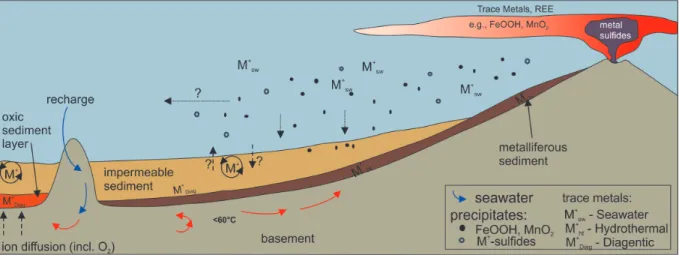
Metals sourced through hydrothermal fluids can form precipitates in the water column and/or be scavenged by particles settling on the seafloor (e.g., Sander and Koschinsky, 2011; Yücel et al., 2011; Hawkes et al., 2014), or removed from the water column to the sediment by adsorption onto iron-colloids (see Hawkes et al., 2014). Sulfide precipitates have been observed to travel over long distances (Yücel et al., 2011), likely impacting sedimentary environments distal to the hydrothermal source. In the sediments, metals either accumulate in the solid phase or are released back into the water column through diagenetic processes (Fig. 5.1).
Fig. 5.1: Schematic sketch showing the general circulation pattern of fluids through the crust and release from the vent impacting the cycling of metals at a hydrothermal vent system and adjacent
deposits. M represents vent associated metals (modified after Wheat et al., 2002; German et al., 2016).
Our main objective is to identify metal cycling in sediments proximal to and impacted by hydrothermal vents, and to distinguish hydrothermal deposits from sediments that have been re-oxidized by hydrothermal fluids (crust circulating fluids). To address the above objective we plan to develop a matrix of geochemical tracers, including strontium isotopes, noble metals, rare earth elements (REE), and redox-sensitive elements and their isotopes (including Mo, U, Fe), to characterize the hydrothermally sourced sediment recovered from an active site in the East Scotia Ridge (ESR).
The isotopic composition of strontium is a strong tracer for the alteration of volcanic derived material (e.g., Hensen, et al., 2007; Scholz et al., 2009). Thus, sediment where the TM input is related to volcanoclastic sources will show a strong depletion in the 87Sr/86Sr ratios, which is readily apparent in sediment and pore water samples (e.g., Dasch, 1969).
Hydrothermally-derived sources have unique noble metals and rare earth elements (REE) signatures. For example, noble metal concentrations, such as gold, palladium, platinum, and silver, show characteristic concentrations in individual hydrothermal fluids and thus can be used to fingerprint the source of metal enrichments in nearby sediments (e.g., Crocket, 1990). Rare earth elements (REE) are released through high temperature venting into the water column (Michard and Albarède, 1986; Klinkhammer et al., 1994) and are scavenged onto Mn and Fe (oxyhydr)oxides (Fig. 5.1). Thus, REEs are enriched in metalliferous deposits near these vent systems (e.g., Michard et al., 1983, Mascarenhas-Pereira and Nath, 2010), but are not enriched under anoxic oceanic events. Thus, REE and noble metals can be used to distinguish hydrothermally-derived metal sources from enhanced precipitation of redox-sensitive elements under anoxic oceanic conditions or related to productivity.
We plan to sample fresh and early diagenetic metalliferous deposits using remotely operated vehicle (ROV)-guided push cores at the vicinity of the ridge. We aim to fully characterize the impact of diagenetic metal oxide alteration on the trace metal cycle (including its isotopic composition).
Work at sea
Push core samples will be collected using a remotely operated vehicle (ROV) QUEST 4000 (MARUM). Push cores will be taken at Segment E2, at the chimney, flank and about 80 m away from vents at Dog’s Head and at the Sepia site. Additionally, samples will be taken at one vent at Segment E5, if active hydrothermal vents are observed at this location. Push cores in the immediate vicinity of active seeps will be guided by visual observations and coordinated with the petrology and microbiology teams. Designated long geochemistry cores (gravity or piston cores) will be taken at the rift zone away from the vents and outside the rift zone where enough sediment is available. Gravity/piston cores will be collected avoiding areas with indications of mass transport deposition.
Designated geochemistry cores will be transferred into a cooling room (about 4°C) and processed immediately after recovery. High-resolution pore water sampling will be carried out using Rhizons, and splits for solid phase analysis will be taken at the same depth (for further details see Riedinger et al., 2014). Gravity cores (GC) will be cut into 1 m segments.
On the working halves, pore water samples will be taken in intervals of 20 to 30 cm. Solid phase samples will be collected with 10 mL cut-off syringes at the pore water sampling intervals. All solid phase samples will be stored frozen at -20°C for further analyses. Eh and pH will be determined onboard parallel to the pore-water and sediment sampling intervals.
Additionally, basic pore water analyses such as the measurement of the dissolved iron, total sulfide, alkalinity, ammonium, and phosphate will be carried out onboard using standard methods.
Preliminary (expected) results
During burial sediments undergo early diagenetic alteration that can lead to the release of metals into the pore water and potentially back to the water column. Therefore, fingerprinting the trace metal inventory in the hydrothermal vent system and adjacent sediments will help us to understand the activity and survival of microbial communities in these extreme environments and the impact of trace metals on benthic macro fauna, and to document the availability and necessity of bio-essential trace metals to the subsurface biosphere. Sampling and geochemical analyses will be coordinated with microbiologists and macro-fauna specialists from Germany and England, who will participate in the expedition with the main objective of understanding the role of hydrothermal vents on faunal composition and microbial processes in these extreme environments. Furthermore, metals such as U and Mo are frequently applied for paleo redox reconstructions (Lyons et al., 2009, and references therein). The application of our proposed multi-element approach can provide unique constraints on the contribution of metal-rich vent fluids compared to metal recycling in subsurface environments. Identifying the impact of hydrothermal vent systems on these metals could thus be crucial for its application as redox proxy for sites in vicinity to hydrothermal input.
Data management
The geochemical data sets generated during the cruise and in course of the proposed project as well as contextual details of laboratory methods will be careful documented in lab books and Microsoft Excel spreadsheets. All raw data will be kept intact and archived separately from processed data for data transparency. Data will be available online and freely accessible through the data archive PANGAEA, a member of the ICSU World Data System.