Reihe C Dissertationen Heft Nr. 798
Thomas Grombein
Gravity forward modeling
with a tesseroid-based Rock-Water-Ice approach
Theory and applications in the context of the GOCE mission and height system unification
München 2017
Verlag der Bayerischen Akademie der Wissenschaften
ISSN 0065-5325 ISBN 978-3-7696-5210-9
Diese Arbeit ist gleichzeitig veröffentlicht in:
Reihe C Dissertationen Heft Nr. 798
Gravity forward modeling
with a tesseroid-based Rock-Water-Ice approach
Theory and applications in the context of the GOCE mission and height system unification
Inaugural dissertation
for the fulfillment of the requirements for the academic degree of Doctor of Engineering (Dr.-Ing.)
accepted by
the Department of Civil Engineering, Geo and Environmental Sciences of the Karlsruhe Institute of Technology (KIT)
submitted by
Dipl.-Ing. Thomas Grombein
from Mönchengladbach, Germany
München 2017
Verlag der Bayerischen Akademie der Wissenschaften
ISSN 0065-5325 ISBN 978-3-7696-5210-9
Ausschuss Geodäsie der Bayerischen Akademie der Wissenschaften (DGK) Alfons-Goppel-Straße 11 ! D – 80539 München
Telefon +49 – 89 – 230311113 ! Telefax +49 – 89 – 23031-1283 /-1100 e-mail dgk-post@dgk.badw.de ! http://www.dgk.badw.de
Main referee: Prof. Dr.-Ing. Dr. h.c. Bernhard Heck, Karlsruhe Institute of Technology
Co-referee: Univ.-Prof. Dr.-Ing. Dr. h.c. mult. Reiner Rummel, Technical University of Munich Further members of the doctoral committee:
Prof. Dr. rer. nat. Martin Breunig, Karlsruhe Institute of Technology Prof. Dr.-Ing. Maria Hennes, Karlsruhe Institute of Technology Prof. Dr.-Ing. Stefan Hinz, Karlsruhe Institute of Technology PD Dr.-Ing. Boris Jutzi, Karlsruhe Institute of Technology
Prof. Dr.-Ing. Dr. h.c. mult. Franz Nestmann, Karlsruhe Institute of Technology Day of examination: 20.10.2016
Diese Dissertation ist auf dem Server der Deutschen Geodätischen Kommission unter <http://dgk.badw.de/>
sowie auf dem Server des Karlsruher Instituts für Technologie unter
<http://dx.doi.org/10.5445/KSP/1000068500> elektronisch publiziert
on the sea-shore, and diverting myself in now and then finding a smoother pebble or a prettier shell than ordinary, whilst the great ocean of truth lay all undiscovered before me.”
(Sir Isaac Newton, 1642 – 1727)
Brewster, D. (1855): Memoirs of the life, writings,
and discoveries of Sir Isaac Newton, vol. 2, p. 407.
Due to the increasing availability of global high-resolution digital terrain models (DTMs), it has nowadays become possible to obtain a detailed image of the Earth’s topography.
This enables to precisely determine the gravitational effect of the topographic masses on the Earth’s gravity field. The central technique for this aim is gravity forward modeling (GFM), which is based on Newton’s law of universal gravitation, and allows to convert topographic heights along with suitable density assumptions into corresponding values of the gravitational potential and its derivatives. This topographic gravity forward modeling attracts a growing interest in various areas of geodetic gravity field determination and geophysical studies of the Earth’s composition and structure (e.g., solid-earth sciences).
However, previous GFM methods have proven unsuitable for the increasing accuracy requirements stemming from an improved precision of geodetic measurements. This is due to commonly used simplifications and approximations, such as (i) the use of condensed heights for water and ice masses (rock-equivalent heights), (ii) mass discretizations or arrangements based on planar and spherical approximations, and (iii) assumptions regarding the spectral consistency between band-limited topographic heights and induced gravity, as in residual terrain modeling (RTM) techniques.
This thesis contributes to state-of-the-art GFM in the space domain by providing effective techniques and refinements that overcome these limitations. More concretely, the theory of the Rock-Water-Ice (RWI) approach is developed that encompasses a more realistic modeling of the Earth’s topographic and isostatic masses, i.e., the masses of the continents, oceans, lakes, ice sheets and shelves, as well as their deeper lying (isostatic) compensation masses in the Earth’s interior. The RWI method is characterized by a three-layer decomposition of the Earth’s topography that accounts for a rigorous separate modeling of the rock, water, and ice masses with variable density values. Furthermore, a modified Airy-Heiskanen isostatic concept is applied that is enhanced by additional geophysical information in terms of a seismologically derived depth model of the Mohorovičić discontinuity, i.e., the boundary surface between the Earth’s crust and mantle.
To counteract the increased computational demand of the more complex modeling,
an efficient numerical algorithm is needed for the forward modeling. For space domain
GFM, it has become more and more customary to use a mass discretization based on
tesseroids , which are mass bodies bounded by geocentric spherical coordinate lines, and
hence are directly linked to the curvature of the Earth. Several studies have demonstrated
their superiority over classical prism methods with respect to precision and computation
time. However, for global applications based on high-resolution DTMs, any computational
speed-up with respect to a single mass body leads to a massive improvement in the overall
computation time. This thesis presents a considerable optimization of previously used
tesseroid formulas, where the gravitational field of a tesseroid and its derivatives up to second-order are represented in a compact and computationally attractive form. This allows an efficient numerical evaluation that reduces the overall runtime by about 20 to 55 %, depending on the evaluated gravity field functional. Additionally, to correctly locate topographic masses in space, tesseroids are arranged on an ellipsoidal reference surface.
Within this thesis, the novel tesseroid-based RWI approach is applied to different topo- graphic input data and is used for various gravity field functionals in two main applications.
Both are connected to ESA’s satellite mission GOCE (Gravity field and steady-state Ocean Circulation Explorer) that measured the second-order derivatives of the gravitational potential, commonly known as gravity gradients.
In the first application, RWI-based topographic-isostatic effects are calculated along the orbit of the GOCE satellite and are subtracted from the gravity gradient observations. In this way, the measurement signal is smoothed so that interpolation and prediction tasks, such as harmonic downward continuation of the gradients from satellite altitude to the Earth’s surface, can be executed with an improved numerical stability. While in previous studies such a concept was applied to simulated gravity gradients, this thesis presents the application to real GOCE measurements. As the smoothing effect strongly depends on the variability of the topography crossed by the satellite, this procedure is particularly suitable for regional applications. For a time series when the satellite passed the Himalayan region, a comparison of the observed gradients to the reduced ones reveals significant smoothing effects that are quantified by analyses in the space and frequency domain.
The second application contributes to the task of height system unification , which aims to connect the different locally defined reference levels, conventionally used for national height systems. This is achieved by a satellite-based method which employs global geopotential models derived from data of the GOCE mission, whose limited spectral resolution is extended by high-frequency topographic effects of the RWI approach. To extract these high-frequency signals, a novel (residual) gravity forward modeling method is proposed that allows to perform the required high pass filtering directly in the gravity domain, thus, avoiding the above-mentioned assumption (iii) of the RTM method. By using three representative study areas in Germany, Austria, and Brazil, the benefit and importance of high-frequency topography-implied gravity signals for an accurate estimation of height datum offsets is demonstrated.
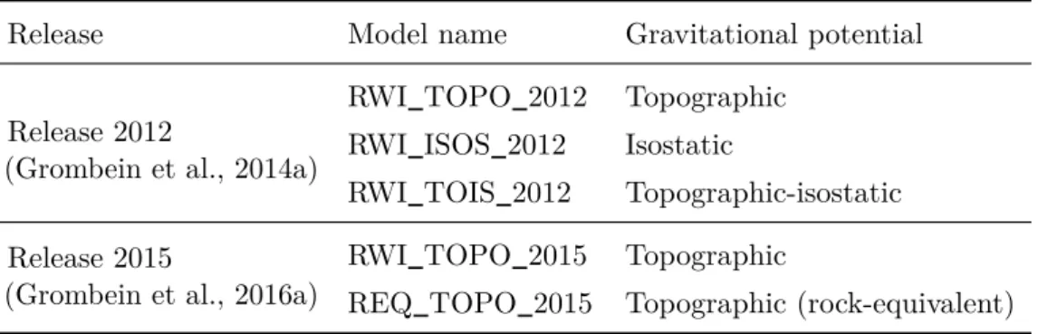
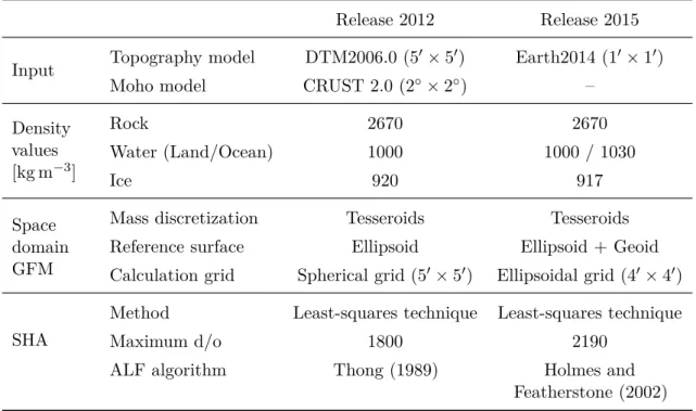
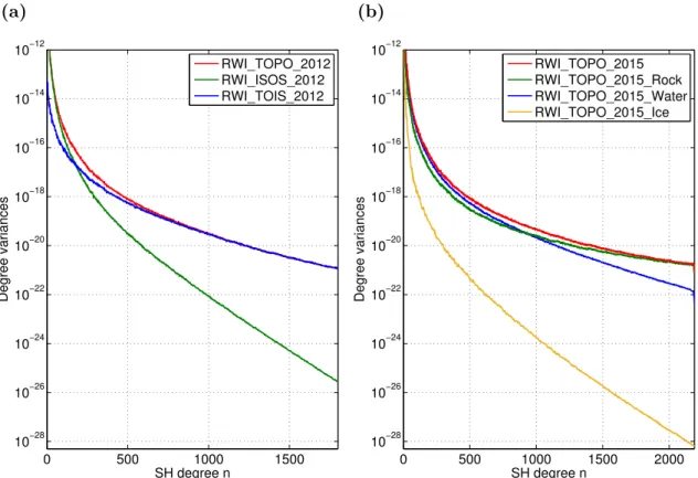
As a highlight of this thesis, the RWI approach is utilized to generate a series of
topographic-isostatic gravity field models. These RWI models provide a high-resolution
representation of the Earth’s topographic-isostatic gravitational potential in terms of
spherical harmonics expanded up to degree and order 1800 (Release 2012), and 2190
(Release 2015). The spherical harmonic coefficients of these models are obtained from a
spherical harmonic analysis of global gridded potential values, which have been calculated
by massive parallel computing on high-performance computer systems. By using spherical
harmonic synthesis, the RWI model can be used to efficiently calculate various functionals
of the topographic-isostatic potential in different heights. For this purpose, the RWI models
are publicly available via the database of the International Centre for Global Earth Models
(ICGEM) and have already been used in a wide range of studies by other research groups.
This article-based (cumulative) thesis consists of a detailed introductory chapter and five chapters associated with the following peer-reviewed publications (four original articles in international journals and one proceedings contribution to an IAG Scientific Assembly):
Grombein, T., Seitz, K., and Heck, B. (2013): Optimized formulas for the gravitational field of a tesseroid. Journal of Geodesy 87(7):645–660. doi: 10.1007/s00190-013-0636-1 . Grombein, T., Luo, X., Seitz, K., and Heck, B. (2014): A wavelet-based assessment of
topographic-isostatic reductions for GOCE gravity gradients. Surveys in Geophysics 35(4):959–982. doi: 10.1007/s10712-014-9283-1 .
Grombein, T., Seitz, K., and Heck, B. (2016a): The Rock-Water-Ice topographic gravity field model RWI TOPO 2015 and its comparison to a conventional rock-equivalent version. Surveys in Geophysics 37(5):937–976. doi: 10.1007/s10712-016-9376-0.
Grombein, T., Seitz, K., and Heck, B. (2017): On high-frequency topography-implied gravity signals for height system unification using GOCE-based global geopotential models.
Surveys in Geophysics 38(2):443–477. doi: 10.1007/s10712-016-9400-4 .
Grombein, T., Seitz, K., and Heck, B. (2016b): Height system unification based on the fixed GBVP approach. In: Rizos, C., and Willis, P. (eds.) IAG 150 years. Proceedings of the IAG Scientific Assembly, Postdam, Germany, Sept. 1–6, 2013. International Association of Geodesy Symposia , vol. 143. Springer Berlin Heidelberg, pp. 305–311.
doi: 10.1007/1345 2015 104.
Mit globalen, hochauflösenden digitalen Geländemodellen (DGMs) stehen heutzutage detaillierte Informationen über die Topographie der Erde zur Verfügung. Diese erlauben es den gravitativen Einfluss der Topographie auf das Erdschwerefeld hochgenau zu bestimmen.
Die zentrale Methode hierfür ist die Vorwärtsmodellierung (gravity forward modeling), die auf dem Newtonschen Gravitationsgesetz beruht und es ermöglicht, topographische Höhen, zusammen mit geeigneten Dichteannahmen, in Schwerepotentialwerte umzurechnen. Diese topographische Vorwärtsmodellierung spielt eine zunehmend größere Rolle in verschiedenen Anwendungen der geodätischen Schwerefeldmodellierung sowie in geophysikalischen Studien zum Aufbau und zur Struktur der Erde.
Durch immer genauere und sensitivere Beobachtungsverfahren sind auch die Genauigkeits- anforderungen an die Vorwärtsmodellierung gestiegen. Bisher verwendete Vereinfachungen und Approximationen müssen daher kritisch hinterfragt werden. Dies betrifft unter ande- rem (i) die Verwendung von kondensierten Höhen für Wasser- und Eismassen (sogenannte rock-equivalent heights), (ii) die planare bzw. sphärische Diskretisierung und Anordnung topographischer Massen, und (iii) Annahmen bezüglich der spektralen Übereinstimmung von Höhen und Schwerewerten, wie im Fall der weit verbreiteten RTM-Methode (residual terrain modeling).
Die vorliegende Arbeit trägt maßgeblich zur aktuellen Weiterentwicklung der Vorwärts- modellierung im Ortsbereich bei, indem neue Methoden und Verfeinerungen bereitgestellt werden, mit denen es gelingt, die oben genannten Einschränkungen zu überwinden. Hierzu wird die Theorie des Rock-Water-Ice (RWI)-Ansatzes entwickelt, der eine realistischere Modellierung der topgraphischen und isostatischen Erdmassen erlaubt. Diese setzen sich aus den Massen der Kontinente, Ozeane, Seen, Eisflächen und dem Schelfeis zusammen, sowie de- ren tiefer liegenden (isostatischen) Kompensationsmassen. Die RWI-Methode ist durch eine Zerlegung der Erdtopographie in drei Schichten gekennzeichnet, die es erlaubt, eine strenge, separate Modellierung der Gesteins-, Wasser-, und Eismassen mit variablen Dichtewerten durchzuführen. Des Weiteren wird ein modifiziertes isostatisches Airy-Heiskanen-Konzept angewandt, welches durch die Verwendung von zusätzlichen geophysikalischen Informatio- nen verbessert wurde. In diesem Zusammenhang werden seismisch bestimmte Tiefen der Mohorovičić-Diskontinuität, d. h. der Grenzfläche zwischen Erdkruste und Erdmantel, in das isostatische Konzept eingeführt.
Um dem gesteigerten Rechenaufwand durch die komplexere Modellierung entgegenzuwir-
ken, sind effiziente Berechnungsmethoden für die Vorwärtsmodellierung notwendig. Für die
Modellierung im Ortsbereich setzt sich hierbei immer mehr die Verwendung von Tesseroiden
durch. Diese Massenkörper sind durch geozentrisch-sphärische Koordinatenlinien begrenzt
und berücksichtigen daher direkt die Krümmung der Erde. In verschiedenen Studien konnte
bereits der Vorteil von Tesseroiden gegenüber der herkömmlich verwendeten Quaderformel gezeigt werden, sowohl hinsichtlich einer gesteigerten Genauigkeit als auch einer verrin- gerten Rechenzeit. In Hinblick auf globale Anwendungen und hochauflösende DGMs ist es dennoch notwendig die Rechenzeit weiter zu reduzieren. In diesem Zusammenhang werden in der vorliegenden Arbeit optimierte Berechnungsformeln präsentiert, wodurch das Schwerepotential eines Tesseroids inklusive seiner ersten und zweiten Ableitungen in einer kompakten und einfach auszuwertenden Form dargestellt werden kann. Dies ermöglicht eine numerisch effiziente Vorwärtsmodellierung, wobei der Gesamtrechenaufwand gegenüber bisher verwendeten Tesseroidformeln je nach Schwerefunktional um 20 bis 55 % sinkt.
Im Sinne einer verbesserten räumlichen Anordnung der topographischen Massen werden Tesseroide zudem auf eine ellipsoidische Referenzfläche aufgesetzt.
In Rahmen dieser Arbeit wird der neu entwickelte RWI-Ansatz unter Verwendung verschie- dener topographischer Eingangsdaten auf unterschiedliche Funktionale des Schwerefeldes in zwei Anwendungen eingesetzt. Beide Anwendungen sind mit der ESA-Satellitenmission GOCE (Gravity field and steady-state Ocean Circulation Explorer) verbunden, welche die zweiten Ableitungen des Gravitationspotentials gemessen hat, die auch als Gravitationsgra- dienten bezeichnet werden.
In der ersten Anwendung werden topographisch-isostatische Effekte mittels des RWI- Ansatzes entlang des GOCE-Satellitenorbits berechnet und als Reduktionen an die ge- messenen Gradienten angebracht. Hierdurch kann eine Glättung des Messsignals bewirkt werden, wodurch sich die numerische Stabilität bei Interpolationsaufgaben und Feldtrans- formationen verbessert, wie z. B. bei einer harmonischen Fortsetzung der Gradienten nach unten, vom Satellitenorbit zur Erdoberfläche. Während diese Vorgehensweise in früheren Untersuchungen auf simulierte Gradienten angewendet wurde, werden in der vorliegenden Arbeit gemessene GOCE-Gradienten topographisch-isostatisch reduziert. Da der erreich- te Glättungseffekt stark von der Variabilität der Topographie abhängt, die der Satellit überfliegt, ist diese Vorgehensweise besonders für regionale Anwendungen geeignet. Durch den Vergleich von gemessenen und reduzierten Gradienten für eine Zeitreihe, in der der Satellit die Himalaya-Region überquert hat, konnten durch eine Analyse im Orts- und Frequenzraum signifikante Glättungseffekte beobachtet und quantifiziert werden.
Die zweite Anwendung trägt zur aktuellen Fragestellung der Vereinheitlichung von Hö-
hensystemen bei. Hierbei sollen die meist lokal definierten Bezugsflächen unterschiedlicher
nationaler Höhensysteme miteinander verbunden werden. In diesem Zusammenhang wird
ein satellitenbasiertes Verfahren vorgeschlagen, welches auf der Verwendung von globalen
Schwerefeldmodellen der GOCE-Mission beruht. Um die spektral begrenzte Auflösung dieser
Modelle zu erweitern, werden hochfrequente topographische Effekte aus der RWI-Methode
eingesetzt. Hierzu wird ein neuer Ansatz zur residualen Vorwärtsmodellierung entwickelt
und getestet. Dieser erlaubt es die notwendige Hochpassfilterung direkt auf Schwerebasis
durchzuführen und ist daher nicht auf die oben erwähnte Annahme (iii) der RTM-Methode
angewiesen. Am Beispiel von drei repräsentativen Untersuchungsgebieten in Deutschland,
Österreich und Brasilien konnte die Bedeutung von hochfrequenten topographischen Schwe-
refeldinformationen für die genaue Berechnung von Höhenoffsets eindrucksvoll gezeigt
werden.
Den Höhepunkt der vorliegenden Arbeit bildet eine Reihe topographisch-isostatischer Schwerefeldmodelle, die unter Verwendung des RWI-Ansatzes generiert wurden. Diese RWI-Modelle liefern eine hochauflösende Darstellung des topographisch-isostatischen Gra- vitationspotentials in Form von Kugelfunktionsentwicklungen bis Grad und Ordnung 1800 (Version 2012), bzw. 2190 (Version 2015). Die Kugelfunktionskoeffizienten dieser Modelle werden über eine sphärisch-harmonische Analyse aus globalen Gittern von Potentialwerten abgeleitet. Für die Generierung der Gitterwerte wird eine stark parallelisierte Berechnung auf Hochleistungsrechnern eingesetzt. Mittels sphärisch-harmonischer Synthese können die RWI-Modelle zur effizienten Berechnung verschiedener Funktionale des topographisch- isostatischen Potentials in unterschiedlichen Auswertehöhen verwendet werden. Zu diesem Zweck wurden die Koeffizienten der RWI-Modelle über die Datenbank des International Centre for Global Earth Models (ICGEM) frei verfügbar gemacht und sind bereits vielfältig in Untersuchungen internationaler Forschungsgruppen zum Einsatz gekommen.
Diese kumulative Dissertation besteht aus einem ausführlichen Einleitungskapitel und fünf Kapiteln, die die folgenden, begutachteten Publikationen beinhalten (vier Artikel in internationalen Zeitschriften und ein Tagungsbeitrag zu einer Konferenz der International Association of Geodesy):
Grombein, T., Seitz, K. und Heck, B. (2013): Optimized formulas for the gravitational field of a tesseroid. Journal of Geodesy 87(7):645–660. doi: 10.1007/s00190-013-0636-1 . Grombein, T., Luo, X., Seitz, K. und Heck, B. (2014): A wavelet-based assessment of
topographic-isostatic reductions for GOCE gravity gradients. Surveys in Geophysics 35(4):959–982. doi: 10.1007/s10712-014-9283-1.
Grombein, T., Seitz, K. und Heck, B. (2016a): The Rock-Water-Ice topographic gravity field model RWI TOPO 2015 and its comparison to a conventional rock-equivalent version. Surveys in Geophysics 37(5):937–976. doi: 10.1007/s10712-016-9376-0 . Grombein, T., Seitz, K. und Heck, B. (2017): On high-frequency topography-implied gravity
signals for height system unification using GOCE-based global geopotential models.
Surveys in Geophysics 38(2):443–477. doi: 10.1007/s10712-016-9400-4 .
Grombein, T., Seitz, K. und Heck, B. (2016b): Height system unification based on the fixed GBVP approach. In: Rizos, C., und Willis, P. (Hrsg.) IAG 150 years. Proceedings of the IAG Scientific Assembly, Postdam, Germany, 1.–6. Sep. 2013. International Association of Geodesy Symposia , vol. 143. Springer Berlin Heidelberg, S. 305–311. doi:
10.1007/1345 2015 104 .
I. Introductory chapter . . . . 1
1. Introduction . . . . 1
1.1. Motivation and background . . . . 1
1.2. Outline . . . . 4
2. Foundations . . . . 4
2.1. Gravity forward modeling . . . . 4
2.2. GOCE gravity gradiometry . . . . 6
2.3. Height system unification . . . . 7
3. Problem statements and research objectives . . . . 7
3.1. State-of-the-art of gravity forward modeling . . . . 7
3.2. Research objectives . . . 10
4. Contributions . . . 10
4.1. Optimized tesseroid formulas . . . 11
4.2. The Rock-Water-Ice (RWI) approach . . . 13
4.3. Topographic-isostatic gravity field models . . . 15
4.4. Smoothing of GOCE gravity gradients . . . 20
4.5. Spectral extension in the framework of height system unification . . . . 21
5. Publication overview . . . 24
6. Conclusions and outlook . . . 25
6.1. Conclusions . . . 25
6.2. Outlook . . . 27
References . . . 29
II. Optimized formulas for the gravitational field of a tesseroid . . . . 39
1. Introduction . . . 40
2. Theoretical preliminaries . . . 42
2.1. Gravitational potential of a tesseroid . . . 42
2.2. Definition of partial derivatives . . . 44
3. Optimized tesseroid formulas based on Cartesian integral kernels . . . 45
4. Comparison to tesseroid formulas based on spherical integral kernels . . . . 47
5. Aspects of numerical evaluation . . . 50
5.1. Idea of the Taylor series approach . . . 50
5.2. Adaption of the Taylor series approach . . . 51
5.3. Remarks on the validity and accuracy . . . 54
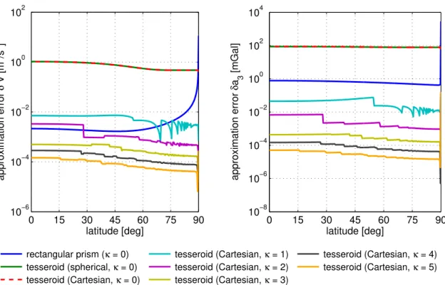
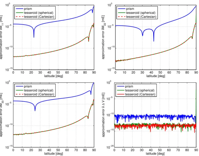
6. Numerical investigations . . . 55
6.1. Comparison of the computation time . . . 55
6.2. Comparison of the approximation error . . . 57
7. Conclusions and outlook . . . 63
Appendix . . . 65
References . . . 65
III. A wavelet-based assessment of topographic-isostatic reductions for GOCE gravity gradients . . . . 71
1. Introduction . . . 72
2. RWI topographic-isostatic reduction method . . . 74
2.1. Topographic reduction . . . 75
2.2. Isostatic reduction . . . 77
2.3. Reduction values at GOCE satellite altitude . . . 78
3. Continuous Morlet wavelet transform . . . 80
3.1. Wavelets and Morlet wavelet . . . 80
3.2. Continuous wavelet transform . . . 82
4. Study area and data sets . . . 85
5. Assessment of topographic-isostatic reductions . . . 87
5.1. Analysis in the space domain . . . 89
5.2. Analysis in the frequency domain . . . 90
6. Conclusions . . . 93
Appendix . . . 94
References . . . 94
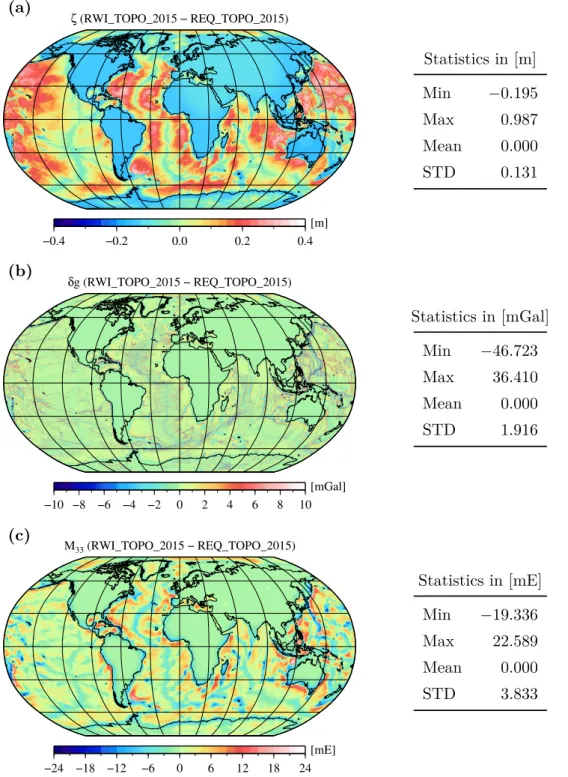
IV. The Rock-Water-Ice topographic gravity field model RWI TOPO 2015 and its comparison to a conventional rock-equivalent version . . . . . 101
1. Introduction . . . 102
2. Method . . . 106
2.1. RWI-based topographic model . . . 106
2.2. REQ-based topographic model . . . 108
2.3. Gravity forward modeling based on tesseroids . . . 109
2.4. Spherical harmonic analysis of gridded data . . . 112
3. Input data . . . 113
4. Processing . . . 116
5. Results and discussion . . . 123
5.1. RWI TOPO 2015 . . . 124
5.2. Comparison to RWI TOPO 2012 . . . 129
5.3. Comparison to REQ TOPO 2015 . . . 130
6. Validation . . . 133
7. Conclusions and outlook . . . 137
Appendix . . . 138
References . . . 142
V. On high-frequency topography-implied gravity signals for height
system unification using GOCE-based global geopotential models . . 149
1. Introduction . . . 150
2. Satellite-based height system unification . . . 152
2.1. General considerations . . . 152
2.2. Combination of GOCE GGMs and EGM2008 . . . 154
2.3. Topography-implied gravity signals . . . 155
2.4. Estimation of height datum offsets by least squares adjustment . . . 158
3. Study areas and data sets . . . 159
3.1. Study areas . . . 159
3.2. GNSS/leveling data sets . . . 160
3.3. Global geopotential models . . . 162
3.4. Homogenization of the data . . . 163
4. Error analysis . . . 164
4.1. Omission error . . . 164
4.2. Commission error . . . 165
4.3. Estimation of uncertainties . . . 168
5. Results and discussion . . . 172
5.1. Optimized combination of GOCE GGMs and EGM2008 . . . 172
5.2. Contribution of topography-implied gravity signals . . . 174
6. Conclusions and outlook . . . 178
Appendix . . . 180
References . . . 180
VI. Height system unification based on the fixed GBVP approach . . . . . 191
1. Introduction . . . 192
2. Fixed GBVP approach . . . 193
2.1. Extension to gravity anomalies . . . 195
2.2. Least squares adjustment . . . 197
3. Closed loop simulation . . . 197
4. Conclusions and outlook . . . 199
References . . . 201
Acknowledgments . . . . 203
“So that I may perceive whatever holds the world together in its inmost folds”
(Johann Wolfgang von Goethe, Faust I, V. 382f., transl. by George M. Priest)
I. Introductory chapter
1. Introduction
1.1. Motivation and background
Ever since, humanity desires to know “ whatever holds the world together in its inmost folds ”.
Although the answer to this more general and philosophical question is sought in various disciplines, from the perspective of geodesy, the decisive role is certainly played by gravity – and, more concretely, the phenomenological and quantitative effect of gravitation on our planet Earth.
In this context, the primary task of geodesy is to determine the figure of the Earth and its time-variable external gravity field, where both aspects are closely related to each other (Torge and Müller, 2012, p. 2). The Earth’s gravity field is composed by a gravitational and a centrifugal component, which result from the attraction of the Earth’s masses and the Earth’s rotation, respectively. Mathematically, the gravity field is a conservative vector field that is usually represented by a scalar potential, namely the gravity potential W . The geometry of the gravity field can be illustrated by equipotential surfaces, i.e., surfaces of constant gravity potential. A distinguished equipotential surface with a fundamental meaning is the geoid, which in first approximation can be associated with the mean sea level (MSL) that is conceptionally extended below the continents. Conventionally, the geoid is defined by the potential value W = W
0.
The gravity potential W results from the sum of the gravitational potential V and the
centrifugal potential Z , i.e., W = V + Z . The centrifugal potential Z at an Earth’s surface
point P can be calculated analytically as a function of the orthogonal distance of the
point to the Earth’s rotational axis, and the Earth’s angular velocity ω , which can both
be measured very precisely. Hence, the main challenge of gravity field modeling is the
accurate determination of the gravitational potential V that depends on the mass density
distribution in the Earth’s interior. As this information is not globally known with sufficient
accuracy and spatial resolution, gravity field determination is usually related to the solution
of the Geodetic Boundary Value Problem (GBVP, Heiskanen and Moritz, 1967, p. 36f.).
Depending on whether the theory of Stokes or Molodensky is used, the geoid or the Earth’s surface is employed as the boundary surface, respectively. For the determination of the required boundary values, various measurement approaches can be applied, which are based on the observation of different gravity field functionals on or close to the Earth’s surface.
These include:
Terrestrial gravity measurements. Based on the principle of gravimetry, gravity values g can be measured at the Earth’s surface, where g ( P ) = | grad W ( P ) | denotes the modulus of the gradient of the gravity potential at a point P . These terrestrial gravity measurements provide highly precise information and are the basic observables within the solution of the GBVP. However, they can only be determined pointwise and require time-consuming and expensive field work. For this reason, gravity data is generally inhomogeneously distributed and of varying quality. Moreover, for larger parts of the Earth, the access is restricted or no data is available. Due to these gaps in the global gravity coverage, a gravity field determination solely based on terrestrial data might only be possible on a regional scale.
Satellite altimetry. For the coverage of the oceans, information derived from satellite altimetry can be utilized. In this case, the height of the sea surface above a reference ellipsoid is measured by means of radar techniques. Differences between the observed sea surface and the geoid can be attributed to the sea surface topography. In order to derive precise gravity field data, i.e., geoidal heights, from satellite altimetry, a suitable separation between the geoid information and the sea surface topography needs to be performed.
Satellite-based gravity field missions. In contrast to terrestrial gravity data, the main benefit of satellite-based gravity field observations is that they provide independent and homogeneously distributed information with a consistent accuracy and a nearly global coverage. However, due to the decay of gravity with distance, the measurement sensitivity in satellite altitude decreases with an increasing distance from the Earth’s center of mass.
Therefore, gravity field information recovered from satellite-based missions is generally restricted in terms of its spatial and spectral resolution. The most prominent gravity field missions are CHAMP (CHAllenging Minisatellite Payload), GRACE (Gravity Recovery And Climate Experiment), and GOCE (Gravity field and steady-state Ocean Circulation Explorer), see Rummel et al. (2002) for an overview about their respective measurement concepts and objectives.
In addition to these measurements, the demand for a precise knowledge of the gravitational effect of the Earth’s topography gained an increased interest within current gravity field modeling and has become more and more important in recent years. Analyzing the spectral composition of the gravity field, the high-frequency components can mainly be attributed to the gravitational attraction of the Earth’s topographic and isostatic masses. These encompass the rock, water, and ice masses of the continents, oceans, lakes, and ice sheets, as well as their deeper lying (isostatic) compensation masses in the Earth’s interior.
By using the information of global high-resolution digital terrain models (DTMs), the
topographic-isostatic potential and related functionals can be determined by gravity for-
ward modeling (GFM), see Sect. 2.1, and utilized for various applications in geodesy
and geophysics. While Table 1 provides a general overview of the main applications of
topographic-isostatic GFM and their purposes, they are summarized in the following:
Table 1. Main applications of topographic-isostatic gravity forward modeling.
Application Purpose
Mass reductions Solution of the GBVP according to the theory of Stokes Interpretation of observations in geophysical studies Smoothing Numerical stabilization of interpolation tasks
Numerical stabilization of field transformations Spectral extension Augmentation of band-limited measurements
Reduction of the omission error of GGMs
Gravity prediction Improvement of the spatial resolution of terrestrial data sets Fill-in information for the construction of combined GGMs Validation Independent evaluation of satellite-based GGMs
Verification of new methods, theories, and algorithms
1) Mass reduction. In physical geodesy, topographic-isostatic mass reductions are utilized to obtain mass-free boundary values at geoid level as required for the solution of the GBVP according to the theory of Stokes (Heiskanen and Moritz, 1967, Chapter 3). In geophysical studies and solid-earth sciences, topographic mass reductions of gravity field observations are needed to interpret crustal structures (Ebbing et al., 2001;
Tenzer et al., 2012), to analyze mass anomalies in the Earth’s interior (Wieczorek, 2007), or to perform a general lithospheric modeling (Bouman et al., 2015).
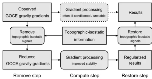
2) Smoothing. Many calculation methods in gravity field modeling are embedded in a remove-compute-restore framework (Forsberg and Tscherning, 1997), where topographic-isostatic information is used to smooth gravity field observations. In this context, the main purpose is to achieve a numerical stabilization of interpolation tasks or field transformations (Forsberg, 1984, Sect. 4). Such a procedure is frequently used for harmonic downward continuation of airborne and satellite-based measurements (Novák et al., 2003; Makhloof and Ilk, 2008; Wild and Heck, 2008; Janák et al., 2014), but is also applied for a gravimetric geoid determination (Omang and Forsberg, 2000).
3) Spectral extension. In recent years, one of the most important applications of
topographic GFM is the spectral extension of band-limited gravity field observations
or global geopotential models (GGMs). This is particularly important in the case of
satellite-derived GGMs, which are generally restricted to long and medium wavelengths
according to the maximum degree of their spherical harmonic representation. To
determine the remaining signal above this maximum degree, known as the omission
error of the GGM, topographic GFM is usually applied in terms of residual terrain modeling (Forsberg and Tscherning, 1997).
4) Gravity prediction. Topographic-isostatic gravity information can be utilized to refine the spatial resolution of terrestrial data sets. This is of special interest for regions where no or only limited gravity data is available, like in Africa (Abd-Elmotaal et al., 2016). In this context, Hirt et al. (2016) recently presented a combination of satellite-based gravity data with topographic information in order to improve the spatial resolution of the gravity field information for Antarctica. Moreover, topographic-isostatic gravity data is needed as fill-in information for the compilation of combined global high-resolution gravity field models, like EGM2008 (Pavlis et al., 2012); see also Hirt et al. (2013) and Fecher et al. (2015, 2016) for other examples.
5) Validation. As an independent source of gravity field information, topographic- isostatic gravity data can be used to assess the performance of GGMs (Tsoulis and Patlakis, 2013). Recently, this has particularly been done to evaluate the improvements gained from different releases of GOCE satellite-based GGMs (Hirt et al., 2012, 2015).
Moreover, topographic-isostatic information is applied to construct a synthetic Earth gravity model (Kuhn and Featherstone, 2005), which can be used for testing and verification of new methods, theories, and algorithms (Baran et al., 2006).
1.2. Outline
The rest of this introductory chapter is organized as follows: in Sect. 2, the general principle of GFM is introduced considering space and frequency domain techniques. Additionally, background information is provided for the two central applications related to the GOCE gravity field mission and height system unification. In Sect. 3, the limitations of current GFM approaches are outlined, and, based on this consideration, the research objectives of this thesis are defined. While Sect. 4 summarizes the main contributions of this thesis, Sect. 5 provides an overview of the related publications as presented and reprinted in Chapters II – VI. An overall conclusion of the thesis including an outlook to future research can be found in Sect. 6.
2. Foundations
2.1. Gravity forward modeling
Gravity forward modeling (GFM) is generally based on the evaluation of Newton’s integral for the gravitational potential of a solid body Ω ⊂ R
3(Heiskanen and Moritz, 1967, p. 3):
V ( P ) = G
Z Z ZΩ
ρ
` dΩ , (1)
where G denotes Newton’s gravitational constant, ρ = ρ ( Q ) is the location-dependent density
function, and ` = ` ( P, Q ) is the Euclidean distance between the attracted computation
point P ∈ R
3and the running integration mass point Q ∈ Ω. Depending on the specific application, the integration domain Ω can extend over quite different mass distributions, with the primary example being the Earth’s topographic-isostatic masses. However, in each case, information on the geometry and density of the mass distribution is required.
In the frequency domain, Newton’s integral in Eq. (1) can alternatively be represented by a series of solid spherical harmonics. In terms of geocentric spherical coordinates ( r, ϕ, λ ), this spherical harmonic expansion is expressed by (Heiskanen and Moritz, 1967, p. 59):
V ( P ) = GM r
∞
X
n=0
R r
n n
X
m=0
C
nmcos mλ + S
nmsin mλ
P
nm(sin ϕ ) , (2) where GM is the geocentric gravitational constant, R is the radius of a reference sphere, P
nmdenotes the fully normalized associated Legendre functions (ALFs) of degree n and order m , and C
nmand S
nmare the fully normalized spherical harmonic (SH) coefficients.
According to the representations in Eqs. (1) and (2), different GFM methods have been proposed that can be classified as space and frequency domain techniques (e.g., Kuhn and Seitz, 2005). In Fig. 1, a general processing scheme for GFM in both domains is presented and is described in the following two paragraphs.
GFM based on Newton’s integral
Space domain GFM Frequency domain GFM
Mass discretization
(elementary bodies)Analytical/numerical integration
Superposition principle
Potential values V
SHA of heights h
(raised to integer powersi)
Surface SH coefficients C
nm(hi), S
nm(hi)Series expansion of height coefficients
Potential coefficients C
nm, S
nmSHA
SHS
Fig. 1. General processing scheme for gravity forward modeling (GFM) in the space and
frequency domain (Grombein et al., 2016a). The results of both GFM methods, i.e.,
potential values or coefficients, can be converted to each other by means of spherical
harmonic analysis (SHA) and synthesis (SHS).
In the case of space domain GFM , Newton’s integral in Eq. (1) is evaluated by a mass discretization. In the first step, the integration domain Ω is decomposed into elementary mass bodies Ω
∗i⊂ Ω with assumed constant density values ρ
i, where Ω =
SΩ
∗i. Depending on the type of application (local, regional, global) and the accuracy requirements, various mass bodies or suitable approximations are frequently used, see Kuhn (2000, Chapter 6) and Wild-Pfeiffer (2008) for a detailed overview.
In a second step, the gravitational potential V
i∗of each individual mass body is calculated by analytical or numerical integration. In the third step, the potential V of the whole mass distribution is then approximated by the sum of the potential values V
i∗according to the superposition principle:
V ≈
Xi
V
i∗=
Xi
Gρ
iZ Z Z
Ω∗i
1
` dΩ . (3)
Analogously, this procedure can be applied to the derivatives of V .
For frequency domain GFM , Newton’s integral in Eq. (1) is evaluated through a transfor- mation into the frequency domain (Rummel et al., 1988; Wieczorek, 2007; Hirt and Kuhn, 2012). In the first step, global gridded DTM heights h are raised to integer powers, i.e., h
iwith i ∈ N, and the corresponding surface SH coefficients ( C
nm(hi), S
nm(hi)) are calculated via spherical harmonic analysis (SHA). In a second step, the solid SH coefficients ( C
nm, S
nm) of the potential are calculated based on a series expansion of the inverse distance, involving the surface SH coefficients ( C
nm(hi), S
nm(hi)) obtained from the DTM heights. In the third step, the derived set of SH coefficients ( C
nm, S
nm) can be used to calculate potential values and functionals via spherical harmonic synthesis (SHS) according to Eq. (2).
2.2. GOCE gravity gradiometry
As the first core mission of the Living Planet Programme, initiated by the European Space Agency (ESA), the satellite mission GOCE observed the Earth’s static gravity field between November 2009 and October 2013 (ESA, 1999). Based on the concept of satellite gravity gradiometry (Rummel and Colombo, 1985), GOCE measured in-situ the second-order derivatives of the Earth’s gravitational potential at an altitude of about 250 km. These derivatives are specified in a local Cartesian coordinate frame ( x
1, x
2, x
3) and can be arranged in the symmetric Marussi tensor M , where
M
ij= ∂
2V (x
1, x
2, x
3)
∂x
i∂x
j= M
ji, i, j ∈ { 1 , 2 , 3 } (4)
are its physical components, known as gravity gradients. In the context of GOCE gradiom-
etry, gravity gradients are commonly represented in two different coordinate frames: (i) the
instrument-fixed Gradiometer Reference Frame (GRF), where the x
1-axis points in the
flight direction, the x
2-axis is orthogonal to the instantaneous orbit plane, and the x
3-axis
points upwards in the geocentric radial direction, and (ii) the local north-oriented frame
(LNOF), where the x
1-axis points north, the x
2-axis west, and the x
3-axis upwards in the
geocentric radial direction. Within the measurement bandwidth of the GOCE gradiometer
(5 to 100 mHz), the main diagonal tensor components M
11, M
22, M
33and the off-diagonal component M
13were observed with a precision of about 1 to 2 mE / √
Hz (1 E = 10
−9s
−2) in the GRF, while the other off-diagonal components M
12and M
23are less accurately measured with a precision of about 1 E / √
Hz (cf. Rummel et al., 2011).
A primary geodetic mission objective of GOCE is to contribute to global height system unification by providing a precise global geoid with an accuracy of 1–2 cm (Rummel, 2002).
Due to the measurement at satellite altitude and the limited bandwidth of the GOCE gradiometer, the derived geoid is restricted to a spatial resolution of about 100 km. This corresponds to a SH expansion approximately up to degree and order (d/o) 200 in terms of a derived GGM.
2.3. Height system unification
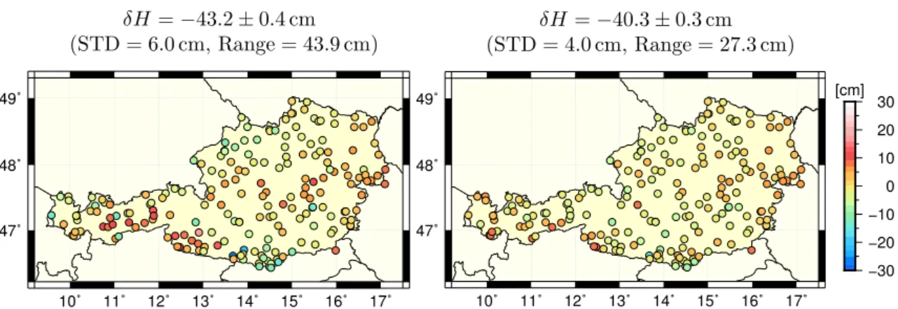
By using tide gauge observations, national height reference systems have conventionally been linked to the local MSL. Due to variations in the sea surface topography, different tide gauges do not realize the same height reference level in terms of a global equipotential surface. Therefore, hundreds of different national height systems exist worldwide that are realized by their own local vertical datum. The resulting discrepancies cause height datum offsets of about ± 1–2 m at a global scale (Heck, 1990; Gerlach and Rummel, 2013; Sánchez, 2015), making it impossible to directly compare the physical heights of different countries.
This can cause practical problems for regional applications, when height information from neighboring countries needs to be combined, e.g., in the case of international engi- neering projects or flooding control. Additionally, for monitoring global geodynamic and climatological processes, such as sea level rise, a consistent physical height reference level is required. Furthermore, height system unification is also relevant for the realization of the Global Geodetic Observing System (Ihde and Sánchez, 2005).
3. Problem statements and research objectives
Due to increasing accuracy requirements for different applications and an improved sensitiv- ity and precision of terrestrial and space geodetic measurements, it is required to scrutinize current approximations and simplifications in gravity forward modeling. If necessary, appropriate refinements of the theory and modifications of commonly used methods have to be taken into consideration.
3.1. State-of-the-art of gravity forward modeling
In geodesy, rectangular prisms (Mader, 1951; Nagy et al., 2000) have traditionally been
utilized for space domain GFM, and are still being applied in the case of the widely-used
GRAVSOFT program routine TC (Forsberg and Tscherning, 2008). While rectangular
prisms are suitable for local applications, they cannot generally be recommended for
applications at a regional or global scale due to their underlying planar approximation. To
improve the rough approximation, prisms with curved surfaces, e.g., topped by a bilinear
surface (Smith et al., 2001; Tsoulis et al., 2003), as well as general polyhedral bodies (Tsoulis, 2012; D’Urso, 2013) have been proposed.
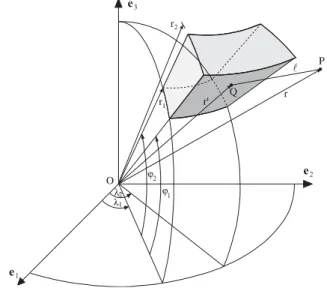
With an increasing number of global applications, tesseroid mass bodies, as introduced by Anderson (1976, p. 48ff.), have become more and more popular in recent years, as they directly take the curvature of the Earth into account. As shown in Fig. 2, tesseroids are bounded by a pair of concentric spheres ( r
1= const., r
2= const.), a pair of meridional planes ( λ
1= const., λ
2= const.), and a pair of coaxial circular cones, defined by the parallels ϕ
1= const., ϕ
2= const. In terms of precision and computation time, various studies have demonstrated the high numerical efficiency when utilizing tesseroids instead of conventional rectangular prisms, see, e.g., Heck and Seitz (2007), Wild-Pfeiffer (2008), and Grombein et al. (2010a, Chapter 7). However, even in the case of tesseroids, one of the main issues of space domain GFM is the still enormous computational demand, particularly when using information of global high-resolution DTMs.
Although this property also holds true for frequency domain GFM, a major advantage is that the gravitational potential is directly represented in terms of SH coefficients (e.g., Rummel et al., 1988; Balmino et al., 2012; Hirt and Kuhn, 2012), allowing to efficiently calculate various gravity field functionals by SHS. However, frequency domain methods suffer from several drawbacks, which are pointed out in the following. Due to the nature of spherical harmonics, frequency domain GFM is generally limited to a spherical approximation, i.e., topographic masses are arranged on a spherical reference surface. As this is insufficient for current high-resolution applications, Claessens and Hirt (2013) proposed a new spectral approach taking into account an ellipsoidal approximation; see also Novák and Grafarend (2005) for the use of an expansion in ellipsoidal harmonics. Another issue is that almost all GFM approaches in the frequency domain are currently restricted to the use of one mass layer of constant density.
Fig. 2. Geometry of a tesseroid used for the space domain GFM (Heck and Seitz, 2007).
A common way to account for density variations of different terrain types is the concept of rock-equivalent heights (REQ), also called rock-equivalent topography (e.g., Rummel et al., 1988; Kuhn and Seitz, 2005; Hirt et al., 2015). By applying a mass conservation condition, the DTM columns of water and ice masses are condensed such that their associated mass elements correspond to an equivalent mass of rock density. Hence, topographic masses can be modeled with a constant density value, which considerably simplifies the GFM calculation. However, the shortcoming of this simplification is a changed geometry with considerable mass displacements, as noted by Tsoulis and Kuhn (2007). Due to the distance dependency, this has also an impact on any derived gravity field functional.
The load of the topographic masses is generally compensated by deeper lying mass distributions in the Earth’s interior. In order to consider these isostatic compensation masses, two concepts are commonly employed in geodesy: the isostatic concept of Airy- Heiskanen and the one of Pratt-Hayford (Göttl and Rummel, 2009). Both models rely on the simplified hypothesis of a local and column-based mass compensation with respect to a particular normal compensation depth D . In the Airy-Heiskanen isostatic concept (Heiskanen and Moritz, 1967, p. 135ff.), the thickness d
0of an isostatic mass column varies, while its density value ∆ ρ is kept constant. Following this idea, the depth D + d
0is then assumed to correspond to the boundary surface between the Earth’s crust and mantle, known as Mohorovičić discontinuity (abbreviated as Moho), and ∆ρ represents the crust-mantle density contrast. On the contrary, the Pratt-Hayford isostatic concept (Heiskanen and Moritz, 1967, p. 134ff.) assumes a constant thickness of an isostatic mass column along with laterally varying density values, depending on the topographic height.
However, both classically applied concepts have their disadvantages and do not provide reasonable results when applied globally. For example, the Airy-Heiskanen isostatic concept fails over deep ocean trenches, where d
0may rise above the ocean bottom (Wild and Heck, 2005). Therefore, several studies suggested to apply a combination of different isostatic concepts, e.g., the use of the Airy-Heiskanen concept over land areas and the Pratt-Hayford model over the oceans (Wild and Heck, 2005; Göttl and Rummel, 2009; Hirt et al., 2012).
Based on a refinement of Airy’s theory, the Vening-Meinesz model (Moritz, 1990, p. 222ff.;
Abd-Elmotaal, 1995) accounts for a regional, instead of local isostatic compensation.
Although such a compensation scheme is more realistic, from a mathematical point of view, the Vening-Meinesz model is much more complicated, making it hardly applicable on a global scale. Moreover, as pointed out by Kaban et al. (2004), additional information about the Earth’s interior and its crustal structure needs to be integrated, in order to achieve a more geophysically meaningful isostatic compensation.
For the spectral extension of band-limited measurements or GGMs, the results of gravity
forward modeling cannot be used directly, as the topography generally contributes to all
spectral scales of the gravity field. In addition, some kind of high-pass filtering has to be
performed. For this purpose, residual terrain modeling (RTM, Forsberg and Tscherning,
1997) is a widely used tool that has been utilized in various studies and for different kinds
of applications (e.g., Hirt et al., 2010; Hirt, 2013; Šprlák et al., 2015). In this approach,
gravity forward modeling is applied to a residual topography between a high-resolution
DTM and a smoothed reference topography, whose spectral information is assumed to be
already contained in the measurements or GGM that should be augmented. In this way, the RTM method presupposes a spectral consistency of topographic heights and implied gravity. However, as pointed out by Hirt and Kuhn (2014), a band-limited topography can also generate a full spectrum gravity field. Therefore, the basic assumption of the RTM approach cannot be considered valid in general. However, this issue has not received due attention so far.
3.2. Research objectives
The general research objective of this thesis is to develop a new, more realistic GFM approach that allows to efficiently calculate topographic-isostatic effects for different gravity field functionals and overcomes the current limitations of other methods as specified above.
Besides this methodological aspect, it is intended to conduct different kind of studies in order to evaluate the performance and see the benefit of the newly developed method. In detail, the following questions and aspects have been addressed within the thesis:
• Is it possible to optimize the currently used tesseroid formulas in order to achieve a significant reduction of the computation time for space domain GFM?
• How does the approximation error of the commonly used rock-equivalent modeling affect different gravity field functionals and which magnitudes can be expected for terrestrial, airborne and satellite-based applications?
• Is it possible to enhance the topographic-isostatic modeling by a rigorous separate modeling of different terrain types with variable density values?
• Can space domain GFM approaches overcome current limitations of global GFM in the frequency domain?
• Is it possible to find an alternative approach to residual terrain modeling that allows to perform the required high-pass filtering directly in the gravity domain?
• Is it feasible to effectively smooth measured GOCE gravity gradients by means of topographic-isostatic reductions?
• Can topography-implied gravity signals profitably contribute to the problem of global height system unification?
4. Contributions
In this section, the main contributions of the thesis are summarized and references are provided with respect to the attached publications. Succinctly stated, these are:
• Elaboration of optimized tesseroid formulas that reduce the computational demand
by about 20 to 55 %, depending on the respective gravity field functional of interest,
see Grombein et al. (2013) in Chapter II.
• Development of the advanced Rock-Water-Ice (RWI) approach that is based on a three-layer decomposition of the Earth’s topography with respect to its rock, water, and ice mass constituents, and a modified Airy-Heiskanen concept that incorporates Moho depths, see Grombein et al. (2014a, 2016a) in Chapters III and IV.
• Release of several Rock-Water-Ice gravity field models (RWI models) that provide a high-resolution representation of the Earth’s topographic-isostatic potential in terms of SH coefficients, see Grombein et al. (2014a, 2016a) in Chapters III and IV.
• Analyses of the benefit of the RWI approach in comparison to the conventional rock-equivalent technique, see Grombein et al. (2016a) in Chapter IV.
• Application of the RWI approach for the topographic-isostatic reduction of measured GOCE gravity gradients, see Grombein et al. (2014a) in Chapter III.
• Development of an alternative to residual terrain modeling based on GFM using the RWI approach and the corresponding RWI models, see Grombein et al. (2017) in Chapter V.
• Application of this strategy for the spectral extension of satellite-based GOCE gravity field models in the context of global height system unification, see Grombein et al.
(2017) in Chapter V.
• Analyses of a newly developed fixed GBVP approach for height system unification, see Grombein et al. (2016b) in Chapter VI.
4.1. Optimized tesseroid formulas
Gravity forward modeling is generally a very time consuming task, where the runtime increases quadratically with the spatial resolution of the used topography model. To handle the enormous computational demand in the case of global high-resolution input data, it is indispensable to use techniques of parallel computation. However, as a first step, it is reasonable to evaluate and optimize existing formulas.
Investigations in this context have concentrated on formulas for the gravitational po- tential V
∗of a homogeneous spherical tesseroid, as well as its first- and second-order derivatives that are defined with respect to a topocentric Cartesian coordinate frame (x
1, x
2, x
3), i.e., ∂ V
∗/∂x
iand ∂
2V
∗/(∂x
i∂x
j) with i, j ∈ { 1, 2, 3 } , respectively. Instead of the local north-oriented frame as defined above and used for the GOCE gradiometry, a conventional left-handed frame is applied, where the x
2-axis points east instead of west.
Previously published tesseroid formulas are based on integral kernels with respect to
geocentric spherical coordinates (e.g., Heck and Seitz, 2007; Wild-Pfeiffer, 2007, 2008). Thus,
in order to calculate the first- and second-order derivatives in the moving Cartesian frame,
additional transformations have to be applied that show polar singularities (Tscherning,
1976). In contrast to these approaches, first ideas of optimized tesseroid formulas based on
Cartesian integral kernels have been formulated in Grombein et al. (2010a), and further
elaborated and generalized within this thesis (cf. Grombein et al., 2013). These formulas avoid the explicit transformation and thus allow to evaluate the first- and second-order derivatives directly in the local Cartesian frame for any position on the globe. Moreover, this leads to a compact representation of the gravitational field functionals of a tesseroid that can be described consistently by the general formula
V
∗(P)
∂
∂xi
V
∗( P )
∂2
∂xi∂xj
V
∗(P )
= Gρ
λ2
Z
λ1
ϕ2
Z
ϕ1
r2
Z
r1
1
`
3
∆x
i∆x
i∆ x
i3∆xi∆xj
`2
− δ
ij