© Lozhkin A. V., Andreev A. A., Anderson P. M., Korzun Yu. A., Nedorubova E. Yu., 2019
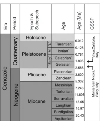
In the continuous annals of changing Arctic bio- cenoses, the interval 2.595–2.554 Ma occupies a special place. This interval corresponds to stages 103–102 of the marine oxygen-isotope (MIS) scale (Lisiecki, Raymo, 2005) and includes a key chronos- tratigraphic marker in the Gauss-Matuyama bound- ary (2.588 Ma), which occurs within MIS 103. Per- haps most importantly, this isotope stage also en- compasses the transition from the Neogene to the Quaternary period. The placement of the Pliocene- Pleistocene boundary has been debated since 1948, in part because initial global cooling that ultimate- ly led to the build up of continental scale glaciers which are the hall mark of the Pleistocene, began in the late Tertiary ~ 2.8–2.4 Ma ago (Gibbard et al., 2010). Consequently, many Quaternary scientists favored an earlier age for this boundary, whereas Neogene stratigraphers argued for the retention of
the original definition. In 1982 at an INQUA meet- ing in Moscow, the Vrica site in Calabria, southern Italy, was suggested as the stratotype for the low- er boundary of the Pleistocene. In 1996, the Execu- tive Committee of the International Union of Geo- logical Sciences (IUGS) approved a new division for the Pliocene named the Gelasian age, whose Glob- al Stratotype Section and Point (GSSP) was located at Vrica. Finally, in 2009 the IUGS approved a pro- posal by the International Commission on Stratigra- phy to lower the basal age of the Gelasian using new data from Monte San Nicola, Sicily. Here the GSSP lies 1 m above the Gauss-Matuyama paleomagnetic boundary (Rio et al., 1998; Lourens, 2008). The as- tronomically tuned age of 2.588 Ma has been round- ed to 2.58 Ma and is now considered as the correct Pliocene – Pleistocene boundary (Fig. 1).
Even after six decades of debate, the Pliocene- Pleistocene boundary remains important for strati- graphic questions and paleoenvironmental recon- structions, especially for understanding the changes
GEOGRAPHY
VEGETATION OF THE EASTERN ARCTIC BETWEEN 2.595–2.554 Mа (Data from Lake El’gygytgyn, North-East Russia)
A. V. Lozhkin1, A. A. Andreev2,4, P. M. Anderson3, Yu. A. Korzun1, E. Yu. Nedorubova1
1North-East Interdisciplinary Scientific Research Institute n. a. N. A. Shilo, FEB RAS, Magadan
2Alfred Wegener Institute Helmholtz Center for Polar and Marine Research, Telegrafenberg A43, 14473 Potsdam, Germany
3Quaternary Research Center, University of Washington, Seattle WA, USA
4Institute of Geology and Petroleum Technologies, Kasan Fedеral University, 420008 Kasan, Russia
E-mail: lozhkin@neisri.ru, korzunjulie@mail.ru, super.exidia@yandex.ru, aandreev@uni-koeln.de, pata@uw.edu
The Pliocene-Pleistocene boundary, set at 2.588 Ma or the base of the Gelasian age, represents a shift in global climates from those of the comparatively warm Pliocene to the cooler condi- tions of the Pleistocene. Lake El’gygytgyn (Chukotka) provides one of the few continuous ter- restrial records that permits a close examination of this important transition in Earth’s climate states. The MIS 102-MIS 103 portion of the El’gygytgyn palynological record indicates that, during the earliest Pleistocene, this area of the Arctic was vegetated by closed Larix-Betula- Alnus forest. Such vegetation contrasts to that of the latest Pliocene, when Larix forest-tundra dominated, and differs from the herb and shrub tundra found today in northern Chukotka. This earliest period of the Gelasian represents the climatic optimum for MIS 103. Even under the most severe conditions during MIS 102, Larix forest-tundra persisted, which differs greatly from the herb tundra that characterized many glacial intervals in the Arctic during the Late and Middle Pleistocene.
Keywords: Gelasia, Pleistocene, Pliocene, pollen analysis, paleovegetation.
DOI: 10.34078/1814-0998-2019-4-38-46
Fig. 1. Late Quaternary stratigraphic scheme from the International Union of Geological Sciences (IUGS).
Arrows mark the ages of key sites used in determining the Pliocene-Pleistocene boundary
Рис. 1. Позднечетвертичная стратиграфическая схема от Международного союза геологических наук (IUGS). Стрелками отмечен возраст ключевых участ- ков, использованных при определении границы плио- цена и плейстоцена
in global climate systems that resulted in an ice-age Earth. In that regard, the need remains to improve understanding of ecosystem responses to cool- ing conditions through the addition of terrestrial records, particularly in sensitive regions like the Arctic. Such a unique chronicle exists in the con- tinuous sediment record from El’gygytgyn Lake.
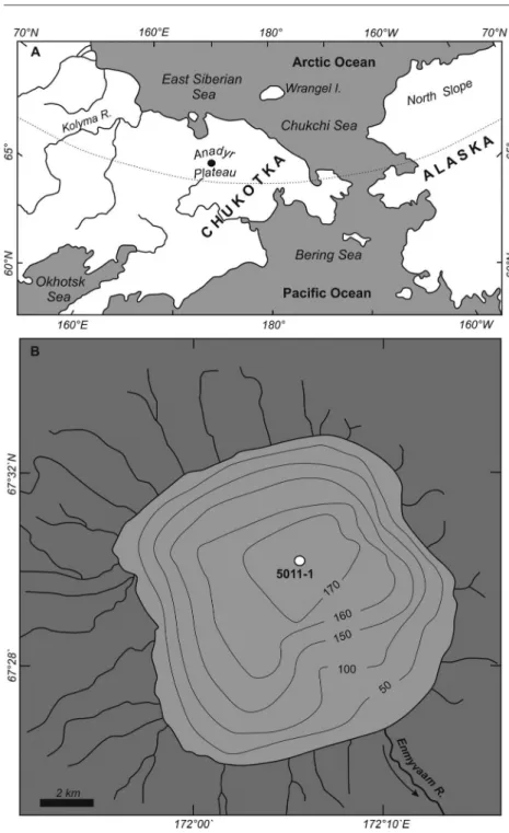
The lake formed ~ 3.6 Ma ago following a mete- orite fall beyond the Arctic Circle in Chukotka at 67º 30’N, 172º05’ (Fig. 2). El’gygytgyn Lake pro- vides the longest continuous record of changes in arctic environments, a record that spans the late Neogene and the Quaternary (Melles et al., 2012;
Brigham-Grette et al., 2013; Wennrich et al., 2016).
In 2009, the “El’gygytgyn Drilling Project” raised several cores (site 5011-1), which combined to in- clude the total 317-meter thickness of sediments (Melles et al., 2012). An age model was established for the composite core (D1), built in part on mag- netic events recorded in the sediments including the Gauss-Matuyama boundary; an age of ~ 3.6 Ma was estimated for core D1 (see Wennrich et al., 2016 for more details).
Andreev et al. (2014, 2016) examined the changes in vegetation as earth’s climate systems shifted from the Pliocene to the Pleistocene with a particular fo-
cus on the 2.7–2.5 Ma interval. They concluded that climate deteriorated at the start of the Pleistocene as indicated by the establishment of steppe and tundra- like communities. However, this climate change was not linear with warmer conditions occurring at sev- eral times during the Early Pleistocene. While em- ploying both qualitative and quantitative interpre- tive techniques, the paleovegetation reconstructions relied heavily on a biomization approach (Prentice et al., 1992; Tarasov et al., 1998). In this method, pollen types are assigned to major vegetation forma- tions or biomes according to modern ecology, bio- climatic characteristics of plants, and spatial patterns of modern pollen distribution. Thus, biomization fo- cuses on broad-scale vegetation characteristics, par- ticularly vegetation structure (e. g., conifer forest, shrub tundra, steppe) as modified by climate type (e. g., cool, dry). Smaller scale variations and char- acteristics of the vegetation are not the primary focus of this approach.
New samples from MIS 102 and MIS 103 have been added to those reported by Andreev et al.
(2016) to fill in some levels where palynological data previously were unavailable. In particular, we have added a sample (sample number 04337, depth 123.552 m, age 2.588041 Ma), which according to the El’gygytgyn age model corresponds precisely to the 2.588 Ma Pliocene-Pleistocene boundary. The spore-pollen spectrum is very close in composition to the spectra of samples taken above the Pliocene- Pleistocene boundary described by Andreev et al.
The assemblage from the 2.588 Ma sample is dom- inated by pollen from trees and shrubs, including Betula (39%), Alnus (43%), Larix (3%), and Sa- lix (1%). Herbaceous plants are represented mainly by Poaceae (8%) and Cyperaceae (2%). Sphagnum (20%) and Polypodiaceae (7%) are the most com- mon spores.
In this paper, we re-examine the vegetation histo- ry during this important stratigraphic transition with a focus on the vegetation communities within the El’gygytgyn crater and the surrounding Anadyr Pla- teau. As described by Andreev et al. (2016), biome models used in reconstructing the paleovegetation of Siberia and the Russian Far East are not without their innate biases (e. g., the Bigelow et al., 2003 model tends to under-represent cold deciduous for- est, whereas the model applied to the El’gygytgyn data (Tarasov et al., 2013) uses fewer tundra classi- fications, resulting in preferential assignment of cer- tain herb assemblages to steppe as opposed to dry tundra). Consequently, we decided on using a more qualitative approach. The paleovegetational inter- pretations presented here are based on knowledge of modern ecology, comparison of fossil to modern pollen spectra, and an understanding of modern pol- len-vegetation-climate relationships at northern high latitudes and in the Russian Far East.
Era Period Epoch & Subepoch Age Age (Ma) GSSP
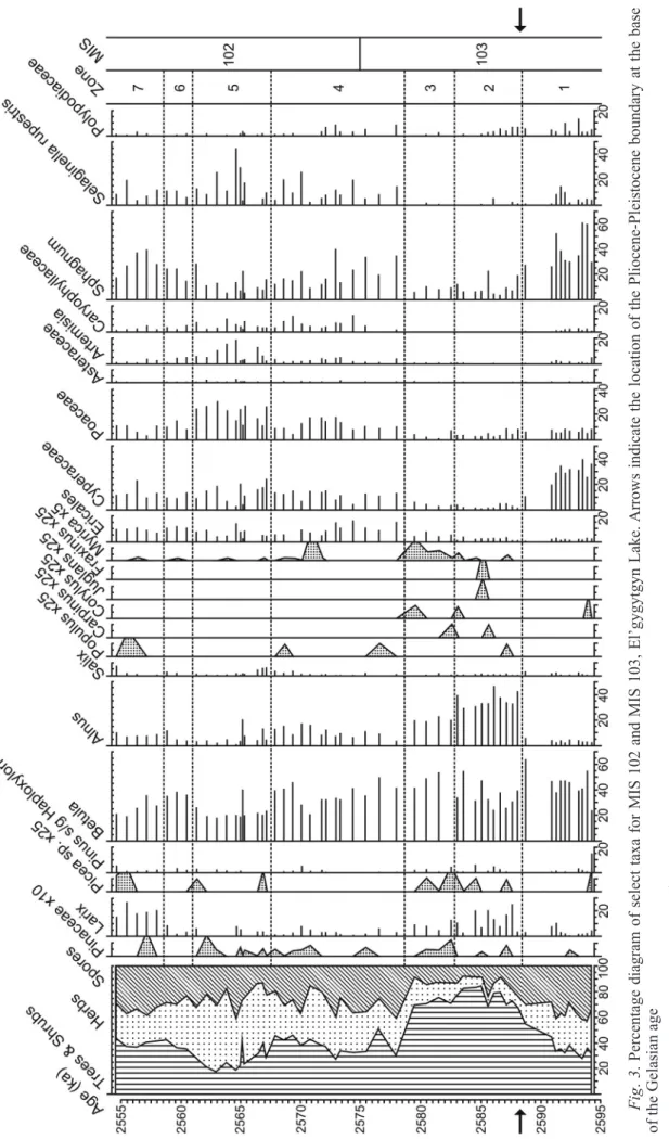
The pollen diagram has been divided into 7 zones based on changes in percentages of the major pol- len taxa (Fig. 3). Percentages of individual taxa are based on a sum of arboreal, nonarboreal, and un- known pollen. Spores are expressed as percent of the pollen sum. Subsum percentages (Trees and Shrubs, Herbs, and Spores) are based on the sum of all pol- len and spores. Zone 1 is from the Late Placenzian age of the Pliocene epoch. Zone 2 through zone 7 en- compass the lower Gelasian age (MIS 102 and MIS 103) with the Pliocene-Pleistocene boundary occur-
ring in mid-MIS 103. The current herb-dominated tundra within the El’gygytgyn crater differs from the shrub tundra of the surround- ing Anadyr Plateau. However, study of modern pollen samples from lacustrine sediments indi- cates that the large lake, not sur- prisingly, captures much wind- blown pollen and thus reflects more the regional than local vege- tation (Lozhkin et al., 2007; Mat- rosova, 2009). Therefore, the fol- lowing descriptions unless oth- erwise noted reflect the broader scale vegetation.
The persistent occurrence of Larix and high percentages of Betula pollen in zone 1 (2595–
2588.4 ka) indicate the presence of Larix forest-tundra both with- in the crater and likely across the Anadyr Plateau. Larix is a large pollen grain which preserves po- orly. Thus, its appearance, even in trace amounts, is strong indica- tion of the tree’s presence on the landscape. High percentages of Betula pollen (> 20%) in modern samples from northeastern Sibe- ria generally are associated with the presence of shrub Betula, sug- gesting its growth in the understo- ry of Larix stands and as an im- portant component of shrub tun- dra in interfluvial areas, perhaps occurring as dense thickets (ye- rniki) on gentle slopes (Ander- son et al., 2002а,b; Lozhkin et al., 2002). However, the presence of tree Betula can not be discounted.
For example, Betula platyphylla, B. lanata, and B. ermanii occur within the modern light conifer- ous forest in coastal areas of the Magadan region. Alnus pollen is
< 5% in zone 1, indicating that it was rare on the landscape. Pinus subg. Haploxylon pollen (likely from the shrub Pinus pumila) registers above presence/absence threshold levels (Anderson et al., 2002а,b) in only the basal sample, suggest- ing that the conifer played a limited role in the veg- etation during early MIS 103 with subsequent input of Pinus pollen during zone 1 representing long-dis- tance wind transport. Both local and regional tundra likely was characterized by graminoid dominated communities, especially as indicated by high Cyper- aceae pollen percentages.
Fig. 2. Maps showing: A – location of El’gygytgyn Lake (black circle), B – bathymetry of the lake. Depths are in meters
Рис. 2. Карты, показывающие местоположение оз. Эльгыгытгын (чер- ный круг) – А и батиметрию озера – В. Глубинa в метрах
Fig. 3. Percentage diagram of select taxa for MIS 102 and MIS 103, El’gygytgyn Lake. Arrows indicate the location of the Pliocene-Pleistocene boundary at the base of the Gelasian age Рис. 3. Диаграмма процента избранных таксонов для MIS 102 и MIS 103, оз. Эльгыгытгын. Стрелками показано расположение плиоцен-плейстоценовой гра- ницы у основания гелазского яруса
Cyperaceae grows across a wide range of ecolo- gies, but often are associated with mesic to boggy areas, the presence of the latter clearly suggested by high percentages of Sphagnum spores. However, the moderate presence of Selaginella rupestris spores suggest disturbed areas on slopes, most likely within the crater.
Zone 2 (2588.4–2582.7 ka) represents the cli- matic optimum for the interval ~ 2.595–2.554 Ma.
The vegetation is characterized by Larix-Betula for- est, which grew within valleys and rolling upland of the plateau and within the crater. The extremely high percentages of Larix pollen in most samples suggest a closed forest (e. g., today in areas of the Kolyma valley with dense Larix forests, modern pollen sam- ples typically contain < 2% Larix and in some sam- ples the pollen is absent (Anderson et al., 2002а,b).
Additionally, dense gallery forests with Larix, tree Betula, tree Alnus (e. g., Alnus hirsuta), Populus, and perhaps tree Salix dominated the valley bot- toms. Chosenia arbutifolia is common today in gal- lery forests in southern areas of northeast Siberia.
This species may also have been present in zone 2, but its pollen is indistinguishable from Salix. The high percentages of Alnus pollen (> 30%) perhaps indicate that these streamside forests were especially rich in tree Alnus, although thickets of shrub Alnus also were present. Similar gallery forests are found today in southern areas of northeast Siberia. Larix cajanderi is the dominant modern species, but Larix sibirica characterized the forests of northeast Sibe- ria before MIS5 (Vas’kovsky, 1959). Trace amounts of Picea pollen appear in several levels, perhaps in- dicative of the limited establishment of this ever- green conifer. However, it is more likely that the grains represent long-distance transport. Pinus per- haps is present in small numbers, but < 10% Pinus subg. Haploxylon pollen suggests that like Picea, the grains are from a population to the south and/
or west of El’gygytgyn (Lozhkin et al., 2002). The minor and sporadic presence of pollen from Carpi- nus, Corylus, Juglans, and Fraxinus in zone 2 sup- ports the “exotic” nature of the conifer pollen, be- cause it is unlikely that these more temperate broa- dleaf trees grew in the region at this time. However, their appearance, albeit in trace amounts, does im- ply a northward movement of a more temperate for- est boundary. The reduction of Cyperaceae and to a lesser extent Poaceae pollen to generally < 10% is a further indication of the extensive establishment of closed forest. However, variable but moderate per- centages of Sphagnum spores and consistent appear- ance of ericaceous pollen suggest the presence of wetter substrates and heath communities. Such asso- ciations are common within present-day open Larix forest. However, given the overall character of the pollen assemblage it seems more probable that these taxa reflect the presence of heaths within the crater.
Myrica, which appears for the first time in the dia- gram, also grows in peaty areas, but the taxon also is found along lake shores, in the forest understory, and wet meadows.
Zone 3 (2582.7–2578.6 ka) is marked by decli- nes in Larix and Alnus pollen but with no change in Betula pollen percentages. The shift in the zone 2- zone 3 assemblages suggests an opening of the Larix- Betula forests and/or a more limited extent of forest, particularly on the plateau. With this shift to cool- er and perhaps drier conditions, shrub Betula may have become a more common landscape element, for example as yerniki or as a member of the for- est understory. Alnus probably continued to occur in both tree and shrub forms, although its presence on the landscape decreased as compared to the ear- lier zone. Ericales pollen, while variable, shows in- creased percentages, indicating an expansion of lo- cal heath communities. A slight increase in Myrica pollen, while still remaining a minor taxon, indicates the persistence or perhaps some expansion of mesic peats and meadows. However, graminoid pollen is generally < 10% suggesting a restricted presence of lakeside meadows and/or the continued regional im- portance of forest.
Trends in the pollen data that began in zone 3 (e. g., decreases in Alnus and Larix pollen, increase in pollen of Ericales) continue in zone 4 (2578.6–
2567.5 ka), indicating further climatic deterioration and reduction of forest on the landscape. The zones also are differentiated by increases in graminoid and ericaceous pollen and Sphagnum and Selaginella ru- pestris spores in zone 4. Caryophyllaceae pollen, ab- sent since zone 1, again is present reaching relative- ly high percentages (~ 5–10%) by mid-zone 4. The change in the palynological assemblage indicates the establishment of Larix forest-tundra on the plateau.
Tree and shrub Betula remained key members of both forest and tundra communities, although low- er pollen percentages suggest that during mid-zone their importance decreased. The lowered percent- ages of Alnus pollen (generally < 10%) indicate its continued decline. By zone 4, tree Alnus may have been absent or occurred rarely, with the pollen repre- senting shrubs that perhaps were restricted primarily to streamside thickets and to mesic soils of hillside draws. The increase in herb pollen suggests an addi- tional opening of the landscape, which began in zo- ne 3. Higher percentages of ericales pollen and Sphagnum spores argue for the continued expansion of heaths and boggy terrain, certainly within the cra- ter and likely across the plateau. However, the in- crease in Selaginella rupestris spores and a lesser increase in Artemisia pollen suggest that disturbed and/or xeric habitats were a greater element of slope vegetation than previously. This change may re- flect primarily a habitat shift within the crater, but the continued increase in percentages of these taxa
in zone 5 may point towards a more regional, cli- mate related trend. High percentages of Caryophyl- laceae pollen is a characteristic of glacial intervals in the El’gygytgyn record and has been associated with an increased importance of meadows near the lake (e. g., Lozhkin et al., 2007). Higher Caryophyl- laceae pollen percentages may also reflect local ex- pansion of meadows, but species within this cosmo- politan family are also associated with shrub thickets and disturbed, well-drained soils of streamsides.
The highest herb pollen percentages, particular- ly Artemisia and Poaceae, occur in zone 5 (2567.5–
2560.9 ka), and percentages of Selaginella rupestris spores reach their maximum. Betula pollen percent- ages are at their lowest in the diagram, and Alnus pollen with the exception of 2 samples remains be- low the modern threshold (> 20%) for the taxon’s presence (Anderson et al., 2002а,b; Lozhkin et al., 2002). Larix pollen occurs in all of the samples in the zone, although often in trace amounts. The pa- lynological assemblage thus indicates the continued loss of forested areas with the dominant vegetation on the plateau being Betula-Salix shrub tundra. Lar- ix was probably restricted to valley bottoms, form- ing a sparser gallery forest as compared to previous zones, and to isolated stands in protected sites away from valleys. Alnus, if present, was not common and occurred only in shrub form. The increase in herb pollen implies an open regional landscape. Addition- ally, increased percentages of Artemisia and Sela- ginella rupestris suggest greater habitats with xe- ric soils and/or disturbed areas most likely on slopes and streamsides. However, percentages of ericales pollen and Sphagnum spores indicate the continued importance of heath communities and boggy terrain.
Graminoid-forb meadows may have been more com- mon locally and across the plateau.
Zone 6 (2560.9–2558.5 ka) is marked by increased Betula, decreased Poaceae, and the continued decline in Artemisia pollen percentages. These changes sug- gest improved climates and expansion of Larix forest- tundra. Betula was the most common shrub in the tun- dra. The mosaic nature of the vegetation, indicating a mix of mesic to xeric and stable to disturbed settings, continues as described in the previous zones.
The dramatic increase in Larix pollen in zone 7 (2558.5–2554 ka) marks the second episode when Larix forest was widespread. In contrast to zone 2, herb pollen percentages are greater, particularly for the graminoids, whereas Betula pollen percentag- es, especially in upper zone 7, are less than in zone 2. These differences in the pollen assemblages sug- gest that while Larix was common in zone 7, the for- ests probably were more open than those established during the earlier climatic optimum. The relatively low percentages of Betula pollen may indicate that the taxon played a more restricted role in the veg- etation as compared to the zone 2 forest. However,
modern lacustrine samples from the Magadan re- gion where Betula occurs as both trees and shrubs indicate presence/absence thresholds of ~ 15%, with most samples having ≥ 20% Betula pollen (Ander- son et al., 2002а,b). Thus, it seems likely that Betula was found within the shrub understory as well as in tree form. Alnus pollen percentages also are signifi- cantly lower in zone 7, suggesting a limited local or regional presence (e. g., < 10% in the fossil spec- tra is below the ~ 20% presence/absence threshold in modern samples). Furthermore, tree Alnus most likely was absent, given the low values in the fossil spectra and its inferred occurrence in shrub form in zones 4–6. Populus and perhaps tree Salix / Chose- nia were members of the gallery forest, with Alnus, Salix and Betula forming streamside thickets. The high percentages of ericales pollen and Sphagnum spores indicate the persistence of heaths and boggy habitats. This landscape may be reminiscent of that found today along the northern coast of the Okhotsk Sea, where a mix of open Larix forest and peatland is common. Low to modest percentages of xeric and/
or disturbed ground indicators, such as Selaginella rupestris and Artemisia, suggest these settings were not common on the landscape. As is the case for the other zones, Pinus subg. Haploxylon pollen occurs in minor amounts indicating the absence of the co- nifer in the El’gygytgyn region. If this pollen type is from Pinus pumila, closed forest, certainly pres- ent in zone 2 and perhaps in zone 7, would not fa- vor the establishment of this coniferous shrub as it requires an open canopy. However, this factor is not relevant for the other zones with more open land- scapes. In these settings the absence of Pinus pumila would suggest that dry winter conditions (i. e., in- sufficient snow cover to protect the evergreen shrub from winter dessication) rather than cool summers (Pinus pumila and Larix share similar summer tem- perature requirements) prevented its establishment in the crater or on the plateau.
The palynological data from the 2.595–2.554 Ma interval from the Lake El’gygytgyn record traces changes in arctic biocenoses across a key climato- stratigraphic boundary between the Piacenzen and the Gelasian ages. This boundary separates the rela- tively warm global conditions of the Pliocene from the increasingly cool “ice-age” climates of the Pleis- tocene. The vegetation during the earliest Pleisto- cene is closed Larix-Betula-Alnus forest and rep- resents the climatic optimum for MIS 102 and MIS 103, the latter stage spanning the above bound- ary. This vegetation contrasts to that of the latest Pliocene, when Larix forest-tundra established un- der conditions that were cooler and drier than dur- ing the Early Pleistocene. A steady deterioration of climate following the optimum is indicated by the continued decrease in forest and increase in tundra until ~ 2560.9 ka. At that time, forest communities
become more widespread, although forest-tundra re- mained as the regional vegetation. By ~ 2558.5, for- est again was common in the El’gygytgyn region.
However, this forest was dominated by Larix and Betula and contrary to the earlier forested period was associated with wetter landscapes. Even during the coolest conditions, the palynological data from MIS 102 indicate the persistence of forest-tundra. These communities differ significantly from herb-dominat- ed tundra, which characterize glacial stages follow- ing the build-up of continental-scale ice sheets in the Northern Hemisphere. As noted by Andreev et al.
(2016), the 2.58 Ma boundary separating the Plio- cene and Pleistocene does not mark an abrupt cli- mate change from a “warm” to “cold” Arctic. As fur- ther remarked by Head and Gibbard (2015), the on- set of glacial conditions during the Pleistocene were the result of complex interactions between global- scale forcing mechanisms (e. g., orbital parameters) with feedbacks among the atmosphere, biosphere, and oceans.
This research was funded by the Russian Fund for Ba- sic Research (Research project No. 19-05-00477). Cor- ing operations were supported by the ICDP, the Far East Branch of the Russian Academy of Sciences, the Russian Foundation for Basic Research, the U. S. National Sci- ence Foundation, the German Federal Ministry of Educa- tion and Research, the Alfred Wegener Institute and Helm- holtz Centre Potsdam, and the Austrian Federal Ministry of Science and Research. We thank L. N. Kotova for help in palynological analysis.
REFERENCES
Anderson, P. M.; Lozhkin, A. V.; Belaya, B. V.;
Stetsenko, T. V., 2002a, Modern Spore-Pollen Spectra from the Mountain Regions of the Kolyma and Indigirka Rivers from Lacustrine Sediments, Quaternary Paleogeography of Beringia, Ed. K. V. Simakov, Magadan, NEISRI FEB RAS, 28–39 [In Russian].
Anderson, P. M.; Lozhkin, A. V.; Belaya, B. V.;
Stetsenko, T. V., 2002b, Modern Spore-Pollen Spectra of Northern Priokhotye from Lacustrine Sediments, Ibid., 51–61 [In Russian].
Andreev, A. A.; Tarasov, P. E.; Wennrich, V.; Raschke, E.; Herzschuh, U.; Nowaczyk, N. R.; Brigham-Grette, J.;
Melles, M., 2014, Late Pliocene and Early Pleistocene Vegetation History of Northeastern Russian Arctic Inferred from the Lake El’gygytgyn Pollen Record, Climate of the Past, 10, 1017–1039.
Andreev, A. A.; Tarasov, P. E.; Wennrich, V.; Melles, M., 2016, Millennial-Scale Vegetation Changes in the North-Eastern Russian Arctic during the Pliocene/
Pleistocene Transition (2.7–2.5 Ma) Inferred from the Pollen Record of Lake El’gygytgyn, Quaternary Science Reviews, 147, 245–256.
Bigelow, N. H.; Brubaker, L. B.; Edwards, M. E.;
Harrison, S. P.; Prentice, I. C.; Anderson, P. M.; Andreev, A. A.; Bartlein, P. J.; Christiansen, T. R.; Cramer, W.;
Kaplan, J. O.; Lozhkin, A. V.; Matveyeva, N. V.; Murray, D. F.; McGuire, A. D.; Razzhivin, V. Y.; Ritchie, J. C.;
Smith, B.; Walker, D. A.; Clayden, S. L.; Ebel, T.;
Gajewski, K.; Hahne, J.; Holmqvist, B. H.; Igarashi, Y.;
Jordan, J. W.; Kremenetski, K. V.; Melles, M.; Oswald, W. W.; Paus, A.; Pisaric, M. F. J.; Shilova, G. N.; Seigert, C.; Volkova, V. S.; Wolf, V. G., 2003, Climate Сhange and Arctic Ecosystems: 1. Vegetation Changes North of 55° N between the Last Glacial Maximum, Mid-Holocene, and Present, Journal of Geophysical Research, 108 (D19), 1870, Alt11-1 – Alt11-25.
Brigham-Grette, J.; Melles, M.; Minyuk, P.; Andre- ev, A.; Tarasov, P.; Deconto, R.; Konig, S.; Nowaczyk, N.;
Wennrich, V.; Rosen, P.; Haltia, E.; Cook, T.; Gebhardt, C.; Meyer-Jacob, C.; Synder, J.; Herzschuh, U., 2013, Pliocene Warmth, Polar Amplification, and Stepped Pleistocene Cooling Recorded in NE Arctic Russia, Science, 340, 1421–1427.
Gibbard, P. L.; Head, M. J.; Walker, M. J. C. and the Subcommission on Quaternary Stratigraphy, 2010, Formal Ratification of the Quaternary System/Period and the Pleistocene Series/Epoch with a Base at 2.58 Ma, Journal of Quaternary Science, 25 (2), 96–102.
Head, M. J.; Gibbard, P. I., 2015, Early-Middle Pleistocene Transitions, Linking Terrestrial and Marine Realms, Quaternary International, 389, 7–46.
Lisiecki, L. E.; Raymo, M. E., 2005, A Pliocene- Pleistocene Stack of 57 Globally Distributed Benthic δ18O Records, Paleoceanography, 20, PA10003.
Lourens, L. J., 2008, On the Neogene – Quaternary Debate, Episodes, 31, 239–242.
Lozhkin, A. V.; Anderson, P. M.; Belaya, B. V.;
Stetsenko, T. V., 2002, Reflections on Modern Pollen Rain of Chukotka from Bottom Lake Sediments, Ed.
K. V. Simakov, Quaternary Paleogeography of Beringia, 40–50, NEISRI FEB RAS, Magadan [In Russian].
Lozhkin, A. V.; Anderson, P. M.; Matrosova, T. V.;
Minyuk, P. S., 2007, The Pollen Record from El’gygytgyn Lake: Implications for Vegetation and Climate Histories of Northern Chukotka Since the Late Middle Pleistocene, Journal of Paleolimnology, 37, 135–153.
Matrosova, T. V., 2009, Change of Vegetation and Climate of Northern Chukotka in the Last 350 Thousand Years (from Palynological Data from Lake El’gygytgyn Sediments), Vestnik NESC FEB RAS, 2, 23–30 [In Russian].
Melles, M.; Brigham-Grette, J.; Minyuk, P. S.; Nowa- czyk, N. R.; Wennrich, V.; DeConto, R. M.; Anderson, P. M.;
Andreev, A. A.; Coletti, A.; Cook, T. L.; Haltia-Hovi, E.;
Ukkonen, M.; Lozhkin, A. V.; Rosйn, P.; Tarasov, P.;
Vogel, H.; Wagner, B., 2012, 2.8 Million Years of Arctic Climate Change from Lake El’gygytgyn, NE Russia, Science, 337, 315–320.
Prentice, I. C.; Cramer, W.; Harrison, S. P.; Leemans, R.; Monserund, R. A.; Solomon, A. M., 1992, A Global Biome Model Based on Plant Physiology and Dominance, Soil Pproperties, and Climate, Journal of Biogeography, 19, 117–134.
Rio, D.; Sprovieri, R.; Castradori, D.; Di Stefa- no, E., 1998, The Gelasian Stage (Upper Pliocene):
a New Unit of the Global Chronostratigraphic Scale, Episodes, 21, 82–87.
Tarasov, P. E.; Andreev, A. A.; Anderson, P. M.; Lozhkin, A. V.; Haltia, E.; Nowaczyk, N. R .; Wennrich, V.; Brigham- Grette, J.; Melles, M., 2013, The biome Reconstruction Approach as a Tool for interpretation of Past Vegetation
and Climate Changes: Application to Modern and Fossil Pollen data from Lake El’gygytgyn, Far East Russian Arctic, Climate of the Past Discussion, 9, 3449–3487.
Tarasov, P. E.; Webb III, T.; Andreev, A. A.; Afanas’eva, N. B.; Berezina, N. A.; Bezusko, L. G.; Blyakharchuk, T. A.; Bolikhovskaya, N. S.; Cheddadi, R.; Chernavskaya, M. M.; Chernova, G. M.; Dorofeyuk, N. I.; Dirksen, V. G.;
Elina, G. A.; Filimonova, L. V.; Glebov, F. Z.; Guiot, J.;
Gunova, V. S.; Harrison, S. P.; Jolly, D.; Khomutova, V. I.; Kvavadze, E. V.; Osipova, I. M.; Panova, N. K.;
Prentice, I. C.; Saarse, L.; Sevastyanov, D. V.; Volko- va, V. S.; Zernitskaya, V. P., 1998, Present-Day and Mid-Holocene Biomes Rreconstructed from Pollen and Plant Macrofossil Data from the Former Soviet Union and Mongolia, Journal of Biogeography, 25, 1029–
1053.
Received 15.04.2019
Received after revision 22.04.2019
РАСТИТЕЛЬНОСТЬ ВОСТОЧНОЙ АРКТИКИ 2.595–2.554 млн лет назад (данные по оз. Эльгыгытгын, Северо-Восток России)
А. В. Ложкин1, A. A. Aндреев2,4, П. М. Андерсон3, Ю. А. Корзун1, E. Ю. Недорубова1
1ФГБУН Северо-Восточный комплексный научно-исследовательский институт им. Н. А. Шило ДВО РАН, г. Магадан
2Институт Альфреда Вегенера Гельмгольца центр полярных и морских исследований, г. Потсдам, Германия
3Вашингтонский университет, факультет наук о Земле и Космосе, центр четвертичных исследований, г. Сиэтл, США
4Институт геологии и нефтегазовых технологий, Казанский федеральный университет, г. Казань, Россия
Граница плиоцена и плейстоцена, установленная на уровне 2.588 млн л. н. (основание гелазия), характеризует изменение глобального климата от климата сравнительно теплого в плиоцене к более холодным условиям плейстоцена. Одну из немногих непрерывных наземных записей изменений климата дают осадки оз. Эльгыгытгын (северная Чукотка). Эта запись позволяет изучить важный переход в климатической истории Земли. Палинологические данные изотопных стадий MIS 102 и MIS 103 в летописи оз. Эльгыгытгын указывают на то, что в самом раннем плейстоцене в этой области Арктики господствовали леса, образованные лиственницей, березой, ольхой. Такая растительность раннего плейстоцена резко отличается от растительности конца плиоцена, когда доминировали лиственничная лесотундра и травянисто-кустарниковая тундра, встречающаяся сегодня на севере Чукотки. Самый ранний период гелазия является климатическим оптимумом для MIS 103. Даже в суровых условиях во время MIS 102 сохранилась лиственничная лесотундра, резко отличающаяся от травянистой тундры, характеризовавшей многие ледниковые интервалы в Арктике во время среднего и позднего плейстоцена.
Ключевые слова: гелазий, плейстоцен, плиоцен, спорово-пыльцевой анализ, палеорасти- тельность.
ЛИТЕРАТУРА Андерсон П. М., Ложкин А. В., Белая Б. В., Сте-
ценко Т. В. Современные спорово-пыльцевые спектры горных районов рек Колыма и Индигирка по данным озерных осадков // Четвертичная палеогеография Бе- рингии / под ред. К. В. Симакова. Магадан : СВКНИИ ДВО РАН, 2002а. С. 28–39.
Андерсон П. М., Ложкин А. В., Белая Б. В., Сте- ценко Т. В. Современные спорово-пыльцевые спек-
Vas’kovsky, A. P., 1959, Brief Sketch of the Vegeta- tion, Climate, and Chronology of the Quaternary Period in the Upper Reaches of the Kolyma and Indigirka Rivers and on the Northern Coast of the Sea of Okhotsk, Ed.
K. K. Markov, Ice Age in the European Part of the USSR and Siberia, Moscow, Lomonosov Moscow State University, 510–545 [In Russian].
Wennrich, V.; Andreev, A.; Tarasov, P.; Fedorov, G.;
Zhao, W.; Gerhardt, C.; Meyer-Jacob, C.; Synder, J.;
Nowaczyk, N.; Schwamborn, G.; Chaplin, B.; Anderson, P. M.; Lozhkin, A. V.; Minyuk, P. S.; Koeberl, C.; Melles, M., 2016, Impact Processes, Permafrost Dynamics, and Climate and Environmental Variability in the Terrestrial Arctic as Inferred from the Unique 3.6 Myr Record of Lake El’gygytgyn, Far East Russia – a Review, Quater- nary Science Reviews, 147, 221–244.
тры Северного Приохотья по данным озерных осад- ков // Там же. Магадан : СВКНИИ ДВО РАН, 2002б.
С. 51–61.
Васьковский А. П. Краткий очерк растительности, климата и хронологии четвертичного периода в вер- ховьях рек Колымы, Индигирки и на северном по- бережье Охотского моря // Ледниковый период на территории европейской части СССР и Сибири / под
ред. К. К. Маркова. М. : Изд-во МГУ, 1959. С. 510–
545.
Ложкин А. В., Андерсон П. М., Белая Б. В., Сте- ценко Т. В. Отражение современного пыльцевого дож- дя Чукотки в донных осадках озер // Четвертичная па- леогеография Берингии / под ред. К. В. Симакова. Ма- гадан : СВКНИИ ДВО РАН, 2002. С. 40–50.
Матросова Т. В. Изменение растительности и климата северной Чукотки за последние 350 тыс. лет (по палинологическим данным осадков оз. Эль- гыгытгын) // Вестник СВНЦ ДВО РАН. 2009. № 2.
С. 23–30.
Andreev A. A., Tarasov P. E., Wennrich V., et al.
Late Pliocene and early Pleistocene vegetation history of northeastern Russian Arctic inferred from the Lake El’gygytgyn pollen record // Climate of the Past. 2014.
Vol. 10. P. 1017–1039.
Andreev A. A., Tarasov P. E., Wennrich V., Melles M.
Millennial-scale vegetation changes in the north-eastern Russian Arctic during the Pliocene/Pleistocene transi- tion (2.7–2.5 Ma) inferred from the pollen record of Lake El’gygytgyn // Quaternary Science Reviews. 2016.
Vol. 147. P. 245–256.
Bigelow N. H., Brubaker L. B., Edwards M. E., et al. Climate change and Arctic ecosystems: 1. Vege- tation changes north of 55°N between the last glacial maximum, mid-Holocene, and present // Journal of Geophysical Research, 108 (D19), 1870, Alt11-1 – Alt11-25. 2003.
Brigham-Grette J., Melles M., Minyuk P., et al. Plio- cene warmth, polar amplification and stepped Pleistocene cooling recorded in NE Arctic Russia // Science. 2013.
Vol. 340. P. 1421–1427.
Gibbard P. L., Head M. J., Walker M. J. C. And the Subcommission on Quaternary Stratigraphy. For- mal ratification of the Quaternary system/period and the Pleistocene series/epoch with a base at 2.58 Ma // Journal of Quaternary Science. 2010. Vol. 25 (2).
P. 96–102.
Head M. J., Gibbard P. I. Early-Middle Pleisto- cene Transitions: Linking Terrestrial and Marine
Realms / Quaternary International. 2015. Vol. 389.
P. 7–46.
Lisiecki L. E., Raymo M. E. A Pliocene-Pleistocene stack of 57 globally distributed benthic δ18O records // Pa- leoceanography. 2005. Vol. 20, PA10003.
Lourens L. J. On the Neogene – Quaternary debate //
Episodes. 2008. Vol. 31. P. 239–242.
Lozhkin A. V., Anderson P. M., Matrosova T. V., Minyuk P. S. The pollen record from El’gygytgyn Lake:
implications for vegetation and climate histories of northern Chukotka since the late middle Pleistocene //
Journal of Paleolimnology. 2007. Vol. 37. P. 135–153.
Melles M., Brigham-Grette J., Minyuk P. S., et al.
2.8 Million Years of Arctic Climate Change from Lake El’gygytgyn, NE Russia // Science. 2012. Vol. 337.
P. 315–320.
Prentice I. C., Cramer W., Harrison S. P., et al. A global biome model based on plant physiology and domi- nance, soil properties and climate // Journal of Biogeogra- phy. 1992. Vol. 19. 117–134.
Rio D., Sprovieri R., Castradori D., Di Stefano E. The Gelasian Stage (Upper Pliocene): a new unit of the glob- al chronostratigraphic scale // Episodes. 1998. Vol. 21.
P. 82–87.
Tarasov P. E., Webb III, T., Andreev A. A., et al. Pres- ent-day and mid-Holocene biomes reconstructed from pollen and plant macrofossil data from the former Soviet Union and Mongolia // Journal of Biogeography. 1998.
Vol. 25. P. 1029–1053.
Tarasov P. E., Andreev A. A., Anderson P. M., et al.
The biome reconstruction approach as a tool for interpre- tation of past vegetation and climate changes: Application to modern and fossil pollen data from Lake El’gygytgyn, Far East Russian Arctic // Climate of the Past Discussion.
2013. Vol. 9. P. 3449–3487.
Wennrich V., Andreev A., Tarasov P., et al. Impact processes, permafrost dynamics, and climate and environ- mental variability in the terrestrial Arctic as inferred from the unique 3.6 myr record of Lake El’gygytgyn, Far East Russia – a review // Quaternary Science Reviews. 2016.
Vol. 147. P. 221–244.