GEOMAR REPORT
Results from the BMBF funded project UDEMM
“Umweltmonitoring für die Delaboration von Munition im Meer”
Version 1.1
Berichte aus dem GEOMAR
Helmholtz-Zentrum für Ozeanforschung Kiel
for Environmental Monitoring of Conventional Munitions
in the Seas
Results from the BMBF funded project UDEMM
“Umweltmonitoring für die Delaboration von Munition im Meer”
Version 1.1
Berichte aus dem GEOMAR
Helmholtz-Zentrum für Ozeanforschung Kiel
for Environmental Monitoring of Conventional Munitions
in the Seas
Das GEOMAR Helmholtz-Zentrum für Ozeanforschung Kiel ist Mitglied der Helmholtz-Gemeinschaft
Deutscher Forschungszentren e.V.
Herausgeber / Editor:
Jens Greinert GEOMAR Report
ISSN Nr.. 2193-8113, DOI 10.3289/GEOMAR_REP_NS_54_2019
Helmholtz-Zentrum für Ozeanforschung Kiel / Helmholtz Centre for Ocean Research Kiel GEOMAR
Dienstgebäude Westufer / West Shore Building Düsternbrooker Weg 20
D-24105 Kiel Germany
Helmholtz-Zentrum für Ozeanforschung Kiel / Helmholtz Centre for Ocean Research Kiel GEOMAR
Dienstgebäude Ostufer / East Shore Building Wischhofstr. 1-3
D-24148 Kiel Germany
Tel.: +49 431 600-0 Fax: +49 431 600-2805 www.geomar.de
The GEOMAR Helmholtz Centre for Ocean Research Kiel is a member of the Helmholtz Association of
German Research Centres
Environmental Monitoring of Conventional Munitions in the Seas
Results from the BMBF funded project UDEMM
“Umweltmonitoring für die Delaboration von Munition im Meer“
Version 1.1
Version / Date Contribution Contributor
26 April 2019 First outline draft UDEMM partners; GEOMAR, CAU, IOW
5 September 2019 First distributed draft V1.1 UDEMM partners; GEOMAR, CAU, IOW,
BLANO, EGEOS
16 September 2019 Added: Biota analyses in section 2.3 GEOMAR
5 November 2019 Added knowledge gaps chapter GEOMAR
5 December 2019 Final editing for Version 1.1 GEOMAR
Editor: Jens Greinert - GEOMAR
With contributions from: Daniel Appel, Aaron Beck, Anja Eggert, Ulf Gräwe, Mareike Kampmeier, Hans-Jörg Martin, Edmund Maser, Christian Schlosser, Yifan Song, Jennifer Strehse, Eefke van der Lee, Rahel Vortmeyer-Kley, Uwe Wichert, Torsten Frey
Financial support was given by: BMBF project UDEMM (grants 03F0747A, B, C); at GEOMAR additionally through in-house funds; at CAU additionally through MATEP as part of the Cluster of Excellence ‘Future Ocean’; WT.SH funding 123 16 006-UKSH and support from MELUND.
UDEMM Practical Guide for Environmental Monitoring
of Conventional Munition in the Seas V1.1 December 2019
Contents
Preface ... 2
1. Conventional munitions in the sea: Threats and problems ... 4
1.1 What are the threats? ... 4
1.2 What are the methodological tasks and problems? ... 7
1.3 Further information and related regulations ... 12
2. Case study Kolberger Heide and western German Baltic Sea ... 15
2.1 History of the study area Kolberger Heide ... 16
2.2 Hydro-acoustic and visual mapping results ... 18
2.3 Munitions compounds in water, sediment and biota ... 20
2.4 Bio-Monitoring ... 32
2.5 Oceanographic field measurements ... 38
2.6 Coupled TNT-GETM model... 40
2.7 Conclusion, knowledge gaps and recommendations ... 46
2.7.1 In Conclusion ... 46
2.7.2 Knowledge gaps ... 47
2.7.3 Recommendation ... 49
3. Practical guidence for sampling and monitoring ... 51
3.1 Scientifically “best” monitoring ... 51
3.2 Baseline Study ... 52
3.3 Long-term monitoring ... 56
3.4 Monitoring during clearance activities ... 60
4. Methodologies ... 62
4.0 Historical Analysis ... 62
4.1 Acoustic mapping and monitoring ... 63
4.2 Visual observations and mapping ... 68
4.3 Field sampling of sediment and biota ... 72
4.4 Habitat mapping ... 72
4.5 Oceanographic monitoring ... 73
4.6 Modelling of currents, TNT distribution including its bio-degradation ... 74
4.7 Water sampling ... 77
4.8 Bio-Monitoring with mussels ... 79
4.9 Chemical analyses of water, sediment and organic matter... 81
4.9.1 Sample preparation ... 81
4.9.2 Analysis ... 82
5. Appendix ... 84
5.1 Analysis of nitroaromatic compounds in mussel tissue (blue mussels) ... 84
Preface
This “Practical Guide for Environmental Monitoring of Conventional Munitions in the Sea” has been developed as part of the joint scientific project UDEMM (March 2016 - June 2019) funded by the Federal Ministry of Education and Research Germany with partners from GEOMAR Helmholtz-Centre for Ocean Research Kiel (GEOMAR), the Christian-Albrechts University in Kiel (CAU) and the Baltic Sea Research Institute in Warnemünde (IOW). Four research groups combined their expertise to test and develop new methodologies, develop a monitoring strategy and investigate the current environmental state of a munitions dumping ground. The detailed objectives were to:
• better understand the current state of munitions contamination in the munitions dumping ground at Kolberger Heide
• apply or newly develop state-of-the-art monitoring technologies for:
a) highly detailed mapping of munitions on the seafloor with hydroacoustic and optical means
b) the chemical analyses of munitions contaminants in water and sediments
c) the uptake of munitions contaminants into organisms and the establishment of toxic thresholds
• setup and advance an existing oceanographic model of the Baltic Sea to extrapolate the distribution of munitions contamination
• verify the validity of assumptions and modelling during sampling campaigns in Kiel Bay and the entire German Baltic Sea
Four research groups worked on these objectives. The group of Prof. Greinert (GEOMAR) applied multibeam mapping technologies, visual investigations by towed camera, autonomous underwater vehicles (AUV) and divers as well as sediment sampling to map and classify munition and the specific habitat within the different study areas. These maps served as base information to guide water sampling and in-situ experiments for TNT dissolution rates that were undertaken by the group of Prof.
Achterberg (GEOMAR). A second focus of Achterberg’s group was to establish a workflow and analytical technologies for measuring munitions compounds (MC) in water samples with very low detection limits on the order of fg/L (10-15g/L). In parallel the group of Prof. Maser (CAU) aimed at using mussels for biomonitoring of munitions contaminants Analytical advancements and toxicological interpretation of data were part of the group’s work. Finally the group of Dr. Graewe (IOW) used the existing Baltic Sea Model (GETM; General Estuarine Transport Model) and implemented chemical and biological modules for the dissolution and turnover of explosive compounds in dependence of seasonally changing current and temperature conditions.
For logistic reasons, the area marked as explosives dumping ground (disused) located in the marine area Kolberger Heide, just off Schönberg (Plön County, Schleswig-Holstein (SH)) was selected as the main study area. This shallow area (7-19m water depth), only 12 nautical miles (nmi) from Kiel, was the ideal location for such scientific studies, easy to reach with GEOMAR vessels and shallow enough for divers and with reasonably good visibility due to the sandy sediment. From the very beginning it was clear that
UDEMM Practical Guide for Environmental Monitoring
of Conventional Munition in the Seas V1.1 December 2019
an integrated approach of geologists/geophysicists, chemists, toxicologists and physical oceanographers was needed to acquire and generate scientifically valid data to fulfil the objectives mentioned above.
The aim of this Practical Guide is to summarize the results of the UDEMM project, give an evaluation of the state of contamination in the Kolberger Heide, introduce the use of commonly available and newly developed technologies and present a blueprint for monitoring efforts with regards to the
“Environmental Monitoring of Conventional Munitions in the Sea”. Some, but not all of the presented results have been published in peer reviewed scientific journals. Several assumptions are presented although a final and scientifically sound proof cannot be given; this is because long-term monitoring still needs to be performed before conclusions can be drawn.
This guide is a living document, which we aim to update in the coming years as part of new projects and in-house investigations. Thus it should not be seen as a final product but rather as a work in progress.
Nevertheless, we believe that substantial progress has been made in developing a monitoring strategy and the necessary technologies, and that these are now accessible to scientists, governmental bodies, NGOs, and companies who are asked to implement such monitoring activities.
1. Conventional munitions in the sea: Threats and problems
1.1 What are the threats?
Several threats exist with regards to munitions in the sea. The most important one today in Germany – and many other countries – is the risk of explosions during underwater construction work. In Germany the establishment of offshore wind-parks for power generation brought the problem of munitions in the sea again to the attention of politicians and the public. Secondly, findings of munitions along beaches and related accidents with munitions washed onshore, including findings of white phosphorous, highlight that munitions dumped after WWI and WWII are not ‘safely stored away’ but constitutes a constant threat that impacts beach visitors. Other threats exist, which are presented in Table 1; the risk levels assigned to these threats are how the UDEMM consortium sees them without claiming that scientifically valid data have been acquired as a basis of this assessment. Our assessment is mainly based on own experience and measurements in the field, through discussions with colleagues from other countries, as well as with authorities in Germany as there are: Ministry of Energy, Agriculture, the Environment, Nature and Digitalization in SH (MELUND), and the German Navy, the Kampfmittelräumdienst – Explosive Ordnance Disposal (EOD) service in SH, the German Federal Maritime and Hydrographic Agency (BSH). A thorough risk assessment was not possible as methods and workflows to generate the necessary data were not available at the beginning of the UDEMM project.
Only after thorough monitoring efforts have been conducted, a reliable risk assessment can be made.
This Practical Guide shows how we, the UDEMM consortium, think such monitoring can/should be done.
Table 1: Current threats as seen by the UDEMM consortium; see more details here1. Threats Risks in the Baltic Sea (regional to
coastal scale)
Risks in Kiel Bay (local scale)
Marine Traffic
Ships run on ground
Low: No reports of such instances;
state of technology and safety features in ships is high.
Low: No reports of such instances; state of technology and safety features in ships is high.
Construction
General construction
Medium: Offshore wind parks are installed in the Baltic and other Seas.
Thorough mapping and clearance of construction sites needs to be done prior constructions.
Low: Currently no large constructions planned in Kiel Bay, however thorough mapping and clearance of local construction sites needs to be done prior constructions.
Dredging
Medium: Most of the area.
Very high: Spatially threats increase, thorough mapping, clearance or other precautionary measures strongly recommended.
Low: With the exceptions of central Hohwachter Bucht and some other restricted areas indicated in official sea charts.
Coastal protection
Medium: Most of the area.
Very high: Spatially threats increase, thorough mapping, clearance or other
Low: With exceptions of small sections of beaches known to be contaminated with warfare material.
1 Only in German: https://www.schleswig-holstein.de/DE/UXO/Berichte/PDF/Berichte/aa_blmp_langbericht.pdf
UDEMM Practical Guide for Environmental Monitoring
of Conventional Munition in the Seas V1.1 December 2019
precautionary measures strongly recommended.
Public & recreational activities
Public awareness
Medium: Concerns are growing that seafood might be contaminated, continuous information is needed.
High: Concerns are growing that seafood might be contaminated, Kolberger Heide is in the news and people want to know if seafood is edible and the water quality is still good. Less concerns about the environment.
Tourism; explosives washed on shore
Medium: Encounters of warfare material and accidents with white phosphorous are reported annually along German Baltic Sea beaches.
Especially white phosphorous mistaken for amber or chunks of explosives washed onshore containing TNT and hexyl brings humans in unintentional contact with hazardous material.
High: White phosphorous has been encountered in Laboe, Hohenfelde and Heiligenhafen; propellants and cartridges on beaches of the inner Kiel Fjord and chunks of explosives north and south of its mouth (Danish Wahld, Probstei).
Scuba diving
Medium: Recreational diving is generally of low risk, if certain areas are avoided. Due to unintentional
relocation of military objects by bottom trawls, safe areas might change their status.
High: Inside and around the ports of Kiel, Lübeck and Neustadt/H., the restricted areas off
Schönberger Strand (BKB04L), off Falshöft (BKB01L) and the central Hohwachter Bucht might as well be heavily contaminated with warfare material as their immediate vicinity is.
Environment and food
Environmental pollution
Medium: UDEMM studies show that TNT contamination of is virtually
‘everywhere’ along the German Baltic Sea; concentrations are in pM to nM levels.
High: At certain hot spots like Kolberger Heide open explosives are in direct contact with sea water.
Uptake of toxic substances into fauna
Medium: Uptake of TNT in organisms has been proven at hot spots such as Kolberger Heide, but less uptake has been observed farther away.
Medium: Uptake of TNT into organisms has been proven, spatial extent of TNT uptake is greatest directly adjacent to munitions (meter scale).
Pelagic fishing Low: Only traces of MCs measured in the water column.
Low: With exceptions of the immediate vicinity of restricted area off Schönberger Strand (BKB04L), the impact area of former firing range training north of Stoller Grund (BKB07L) and Falshöft triangle (BKB01L).
Benthic fishing
Low: Benthic fishing is generally of low risk, if certain areas are avoided carefully. Note: Due to unintentional relocation of military objects by ground trawls areas that are usually recognized as safe might change their status.
Very high: Inside and around restricted area off Schönberger Strand (BKB04L), the impact area of former firing range training north of Stoller Grund (BKB07L) and Falshöft triangle (BKB01L).
Others
Terrorism (collection of Explosives/TNT)
High: Due to proximity to shore, lack of surveillance of dumping grounds and the easy recovery of munitions and explosive chunks.
High: Due to proximity to shore, lack of surveillance of dumping grounds and the easy recovery.
Kolberger Heide is a hot spot!
Wrong risk assessment due to insufficient data and knowledge
Very high: Due to the lack of knowledge about the current state of the munitions integrity/corrosion, a detailed inventory of munitions occurrence, contamination of the environment, uptake by flora and fauna, distribution patterns of dissolved and particulate contaminants due to normal currents and storm events and no knowledge about temporal changes, detailed and reliable assessments are not possible.
Risk scale
Low Known occurrences/incidents are very rare or do not exist, it is very unlikely that circumstances change so that incidences become more likely.
Medium Incidents can and have occurred and pollution was measurable. Good and scientifically correct media information is needed.
High
The threat is real, proximity to shore makes access easy; uninformed information and media-driven worst-case scenarios will heat up the discussion, human threats are seen as more important than environmental damage.
Very high Incidents or threats are imminent; misinformation due to a lack of reliable and accurate data and understanding will lead to wrong decisions.
We identified that delaying the implemention of sustained monitoring programms is the largest threat. Started through the Bund-Länder Ausschuss (since 2018: Bund-Länder Arbeitsgemeinschaft) Nord- und Ostsee, Expertenkreis Munition im Meer (BLANO-Munition), the cooperation between the Federal Republic of Germany and its Federal States of Lower Saxony, Hamburg, Bremen, Schleswig- Holstein and Mecklenburg-Vorpommern needs to continue and should be intensified with one state taking a clear lead, like Schleswig-Holstein does since 2009. Resources for sample collection, analyses, and interpretation (including oceanographic modelling) need to be allocated. Further, an open cooperation between federal and state governmental bodies (BSH, Federal Waterways and Shipping Administration (Wasserstraßen- und Schifffahrtsverwaltung (WSV)), Ministries of Environment, Marine Protection, Economy and the Interior; the German Navy, cross-administration working groups like the BLANO2 and research institutes/centres and universities (Thünen Institute, IOW, GEOMAR, AWI, CAU, …) is essential for establishing a strategy for monitoring munitions in the seas, to constantly improve technologies and to provide updates on risk assessments. A fundamental prerequisite is to accept the threat of environmental pollution from underwater munitions. Starting establishing one joint federated database portal, where data from all stakeholders can be accessed, needs to be part of a successful monitoring strategy. Data security with some of the data being very sensitive needs to be guaranteed and access rights need to be given accordingly. Without joint data management and data exploration capabilities, a comprehensive, correct and thus informed assessments cannot be made and subsequent decisions and actions might not be as effective as anticipated or even cause additional environmental damage.
NOT overcoming data sharing restrictions will make a conclusive environmental assessment impossible.
Doing nothing is NOT an option if a responsible evaluation of this international problem of munitions in the seas is the aim; Germany could take a leading role.
Reporting about munitions in the seas is a threat in itself, when thinking about misusing this data in one or the other way. Transparency towards the general public about the threats, results of investigation and monitoring progresses including potential consequences to food safety and human health issues is
2 https://www.meeresschutz.info/blano.html
UDEMM Practical Guide for Environmental Monitoring
of Conventional Munition in the Seas V1.1 December 2019
important as this will show that the problem of munitions in the seas is taken seriously. However, to a certain extend some information needs to be disclosed from the public; this is particularly true for presenting exact locations of ammunition objects, exact numbers and state of corrosion. Because of this, all detailed maps in this report do not show coordinates. Exact sample locations should not be given in public documents, including scientific publications. UDEMM members, together with partners at the German Navy, the BLANO and Kampfmittelräumdienst Schleswig-Holstein, agreed on publishing coordinates with an accuracy of less than ~180 m (one digit for minute values of coordinates, e.g.
DDD°MM.m’).
1.2 What are the methodological tasks and problems?
Even after overcoming financial, time, data management and responsibility issues, methodological tasks and related problems remain, which need to be considered for a scientifically sound monitoring. Three major tasks exist:
A. how to monitor munitions dumping grounds B. how to define toxicity levels
C. how to evaluate the risks
This guide focuses on the first task of “how to monitor munitions dumping grounds” and gives insights into the definition of toxicity levels. Defining risks or developing decision workflows for evaluating the risks of munitions in the seas was not topic of UDEMM. The parallel running project DIAMON3 focused on this task and presented a first version of a Decision Support Tool. This tool strongly depends on reliable and conclusive data. How to acquire such data was the goal of UDEMM and to focus efforts of such a complex task, one dumping ground type was studied in detail. Within the area of Kolberger Heide, large ammunition objects and chunks of explosives are distributed on the seafloor surface in relatively shallow water. For such and other scenarios the monitoring can be sorted according to five overarching topics:
A. the occurrence/distribution of ammunition objects and their redistribution/ migration over time B. the dissolution flux of contaminants from solid explosives into the water, and the mechanisms
and timescales of conversion into non-toxic substances
C. the spatial and temporal distribution of dissolved and particulate contaminants in the water column
D. the uptake and accumulation of contaminants by organisms and the occurrence within the food web
E. the consequences of munition-related contamination for specific habitats and the environment in general
3 https://www.daimonproject.com/
This guide deals with topics A to D and the respective results gained through the UDEMM project;
ongoing studies will continue to advance knowledge for all topics. The involved processes are shown schematically in Figure 1. Schematic view of the pathways and effects of munitions in the marine environment, and the linkages between monitoring outputs and management outcomes. These processes have been identified and evaluated on different spatial and temporal scales within the Kolberger Heide study site. Work in UDEMM focused on contamination derived from the main charge (mainly Schießwolle 39/gun cotton 39) comprising especially the toxic (e.g., carcinogenic) compound TNT and its metabolites. Inorganic contaminants such as mercury and lead are potentially present in fuses, and are likely also subject to many of the processes shown in Figure 1.
Figure 1. Schematic view of the pathways and effects of munitions in the marine environment, and the linkages between monitoring outputs and management outcomes.
Generally, the contamination and its spread into the environment occurs in dissolved and particulate phase from rusting ammunition objects such as mines, bombs, torpedoes, grenades, etc. In Kolberger Heide one location also shows chunks of open explosives of several decimetres in size and of different colour and texture. Depending on the explosive composition, dissolution rates are controlled by the surface area of the explosive material in contact with water (this will change through time and progressing dissolution), the water temperature and salinity and most likely the turbulence at the explosive surface. This means that dissolution rates are likely to vary seasonally due to temperature changes or increased bottom currents (e.g. storm events) and thus cannot be assumed to be constant.
Dissolved explosive compounds (e.g. TNT, TNT metabolites, RDX) will be transported by water currents and will be subject to biogenic (microbial transformation or uptake by organisms) and abiogenic (e.g.
photolytic) conversion and final degradation or sequestration (Beck et al., 2018). Particulate or surface- adsorbed explosives will be transported with the sediment, buried in sediment, or even washed onshore. The extent to which small particulate explosives are taken up by biota and accumulate into
UDEMM Practical Guide for Environmental Monitoring
of Conventional Munition in the Seas V1.1 December 2019
their tissue is still largely unknown. Rapid dissolution in the water column is likely to limit the redistribution and impact of intact explosive particles.
Dissolved explosive compounds are transported by currents and are substantially diluted during mixing. Knowing type, distance and source strength of the releasing location is of great importance to adequately interpret measured concentration values on different spatial scales. To illustrate the complexity of the problem, Figure 2Error! Reference source not found. shows three different spatial scales, the feature, local, and regional to coastal scale.
We define the feature scale (< 100 m) as the scale where individual ammunition objects or parts of explosives determine the observation/sampling methodology and interpretation. Positioning of sampling needs to be accurate in the centimetre range for e.g. determining dissolution rates of explosive material. Bio-monitoring experiments need to be positioned with at least decimetre accuracy near individual ammunition objects or within meter accuracy with respect to larger clusters of ammunition objects such as piles of sea mines, clusters of depth charges or boxes of munitions.
The local scale (100 - 3000 m) represents entire munitions dumping grounds, which typically show several clusters of dense munitions features. Within Kolberger Heide several feature hot spots were found with sizes ranging between 10 m and 40 m and distances between them are on the order of from 70 m to 500 m. On such scale, the location of individual ammunition objects within a cluster is less important, but the size and integrated source strength of the different clusters will determine the distribution of contaminants. On this scale the overall release strength of a dumping ground needs to be established. Habitat mapping exercises should be performed on such a spatial scale and are ideally compared to similar but uncontaminated areas in the vicinity. The local scale should be large enough to hold several cells of a regional ocean and TNT distribution model to allow for model verifications.
The regional to coastal scale relates to areas covering e.g. the entire exclusive economic zone (EEZ) of the German Baltic Sea with several munitions dumping grounds. Individual ammunition objects are of limited importance on this scale; larger clusters of objects and dump areas will influence the integrated TNT concentrations over several 100 to 1000 m distances (equivalent to a few grid cells of a coastal ocean model).
Figure 2: Overview of the different spatial scales that need to be considered during munitions studies. A) Shows the bathymetry of an area with explosion crates and dumped munitions (ground mines and torpedo heads) in the Kolberger Heide. B) Shows the bathymetry of the Kolberger Heide with ammunition objects marked with grey dots (total 1,136). C) Germany Baltic Sea with points indicating water sampling stations during POS530 (October 2018) and munitions dumping grounds (red), munitions occurrence areas (red pattern) and munitions suspected areas (red polygons).
Table 2 shows the typical studies and applications at different scales as they have been performed during the UDEMM project. Other methodologies and technical devices can be added to the portfolio of a monitoring strategy.
UDEMM Practical Guide for Environmental Monitoring
of Conventional Munition in the Seas V1.1 December 2019
Table 2: Overview of different scales that need to be considered with their typical studies, methods and related problems.
Scale Typical studies and methods Problems
Feature scale single objects or clusters of objects spatial size:
< 100 m temporal scale:
minutes – months
Hydro-acoustic investigations aiming at object detection and inventory assessments; repeated surveys can investigate object migration and burrowing.
Optical investigations aim at resolving objects with a resolution of only one to few pixel/mm. Repeated measurements can be used to detect changes over time. Date acquisition can be done by divers (e.g. small 3D photomosaic reconstructions), remotely operated underwater vehicles (ROVs) or AUVs (larger
photomosaics).
Electromagnetic investigations with towed or ROV/AUV deployed systems aiming at verifying ferro- magnetic objects.
Visual inspection by divers aims at verifying ammunition type and degradation stage.
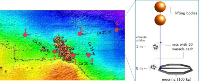
Bio-monitoring experiments by placing mussels in bags on a weight in a certain distance from the target;
making transects and having bags in different height above the seafloor (short mooring) helps to evaluate the spatial impact of contaminates. Passive samples can be placed in the same way. For both, divers are needed in the proximity to ammunition objects, at greater distance > 30 m moorings can be placed from the boat
Sampling of water, sediment, and fauna to establish the extent of contaminant release at source, and to evaluate the extent of ecological exposure at the top high risk location.
Dissolution rate measurements using syringe sampling or chambers. Accurate positioning is needed and due to the proximity to explosives this needs to be performed by divers.
Diver orientation and the weather dependence of diver operations are a typical problem.
Generally accurate underwater localization and navigation is a challenging problem, even with USBL systems.
Visual investigations suffer from turbid water. Different seasons and weather conditions need to be considered.
Hydro-acoustic and electromagnetic measurements need highest position accuracy (RTK support for GNSS).
Environmental samples collected near munitions require diver support due to the explosive hazard.
Local Scale Dump site areas spatial size:
100 - 3000 m temporal scale:
minutes – years
Hydro-acoustic investigations aiming at mapping entire areas but keeping the same high resolution as for feature detection purposes. Data from multibeam systems (bathymetry, backscatter, snippets) or side- scans are further used for habitat mapping and seafloor classification purposes. With increasing depth AUV-based or deep-towed mapping has to replace ship-based investigation due to the decrease of resolution.
Optical investigations with towed or AUV-based camera systems are used for habitat mapping and sediment classification purposes.
Electromagnetic investigations on local scale aim detecting buried munitions that cannot be seen otherwise.
Oceanographic measurements as moored ADCPs
Hydro-acoustic and electromagnetic measurements need highest position accuracy (RTK support for GNSS) and ships navigation (ideally dynamic positioning).
Visual investigations suffer from turbid water. Different seasons and weather conditions need to be considered.
Water sampling by pumps can be slow, so ship positioning is important for accurate spatial sampling on small scales. Rapid water collection with Niskin bottles
(Acoustic Doppler Current Profiler) or CTDs (Conductivity Temperature Depth) record the local variability of physical parameters over longer time (months - years) in high temporal resolution. Such data are used to validate oceanographic model results and as input parameters e.g. in dissolution models.
Sampling of water helps indicate the integrated local source strength, and the extent to which released contaminants are spread away from the source.
Sample depths need to be adjusted to the actual stratification of the water column. Transects across and away from the dumping grounds should be considered, sample spacing can be linked to the model cell size.
Sampling of sediment is needed to ground truth sediment classification (needed for munitions burial estimates), as well as for analyses of explosive compounds (evaluating the extent to which contaminants are accumulated in sediments).
Biota sampling is necessary to determine the extent of ecological exposure outside the immediate
contamination source, yet within the zone of elevated concentrations.
is preferred.
Regional Scale Coastal areas spatial size:
> 3000 m temporal scale:
days to decades
Sampling of water aims at quantifying the spread of contaminants outside of known dumping grounds.
Changing distribution patterns with a focus towards sensitive areas (fishing grounds, tourist areas) will be analysed. Sample depths need to be adjusted to the actual stratification of the water column.
Bio-monitoring at specific locations outside of dumping grounds will support the evaluation of contamination spread and uptake into the food web.
Oceanographic modelling is to determine the integrated source strength of an area and predict spreading over time (warning system).
“Large” amount of water analyses accompanied by physical
measurements are needed for gathering a comprehensive data set. With increasing knowledge and duration of monitoring, the amount of samples can most likely be reduced.
Oceanographic modelling with combined ‘TNT’ dissolution and degradation modules is needed (high performance computing).
1.3 Further information and related regulations
The above short introduction does not claim to be complete in its methods, it is so far the first compilation of munitions monitoring recommendations publically available in Germany and, to our knowledge, in Europe. Ongoing research and monitoring results will contribute to this ‘Best Practices Guide’ and will constantly extend and improve it.
Yearly meetings of researchers, authorities and subcontractors, who execute the monitoring, shall lead to a yearly updated version of this document, results and progress of monitoring should be introduced and maintained under the Monitoring Handbook of BLMP4.
This is the continuation of the work and discussions, which made sure, that the topic of sea-dumped munitions finally reached political levels. First efforts for Northern Europe started in 1974, when the Helsinki Convention introduced first guidelines for the protection of the marine environment of the
4 https://mhb.meeresschutz.info/de/start
UDEMM Practical Guide for Environmental Monitoring
of Conventional Munition in the Seas V1.1 December 2019
Baltic Sea area (Carton and Jagusiewicz, 2009). This led to the federation of the bordering states and the European Economic Community, and the ratification of the HELCOM convention (‘Baltic Marine Environment Protection Commission - Helsinki Commission’) (Carton and Jagusiewicz, 2009). With signing the convention the parties agreed to prohibit sea-dumping of waste, including chemical and conventional munitions (Carton and Jagusiewicz, 2009; HELCOM, 2014). Equivalently, the OSPAR (‘Oslo- Paris Convention for the Protection of the Marine Environment of the Northeast-Atlantic’) convention applies for the North Sea area (OSPAR Commission, 2007). In addition, the European initiative of the Marine Strategy Framework Directive (MSFD) aims for establishing a good environmental status of European waters by 2020. Within the directive’s descriptor 8, munitions disposal sites are explicitly named as a source for contamination and pollution (Law et al., 20105).
To comply with the MSFD, Germany e.g. has established a monitoring program called BLMP (Bund/Länder Messprogramm). This programme has released a public report on Munitions in German Marine Waters - Stocktaking and Recommendations, concluding that the status of munitions within German waters remains unknown to a large extent (Böttcher et al., 2011). Even though the report is updated yearly, the situation in general remains the same, while an effective monitoring procedure has not yet been established. About 300,000 metric tons of conventional munitions and 5,000 metric tons of chemical warfare (CW) material have been brought into German waters of the Baltic Sea. The North Sea contains around 1,300,000 metric tons of conventional and 9,000 metric tons of chemical munitions (Böttcher et al., 2011). In addition of unexploded ordnance from combat and bombing (UXO), all kinds of munitions from onshore munitions depots have been dumped after World War II (WWII) in dedicated nearshore areas. Instead of shipping the munitions to the official dumping grounds, it was common practice to start dumping along the way to the designated areas – also known as ‘on-route-dumping’
(Böttcher et al., 2011; 2015). This and the dislocations of ordnance and initial relocations by fishery activities, make it difficult to estimate exact numbers of munitions inside those areas (Beddington and Kinloch, 2005; Böttcher et al., 2011; 2015; 2016). If not blown in place, defused munitions have been taken out of the water to a large extend (95 % of 21,000 objects reported since 2013) and has been disposed on land. A small fraction though could not be taken out (i.e. British ground mines) but where relocated by the Kampfmittelräumdienst (or EOD service – explosive ordnance disposal service) to a marine dumping ground instead. This is also done because WWII explosives, having rested underwater for seventy years by now, become increasingly unstable and the risk of a spontaneous detonation during transport, particularly onshore, has strongly increased (Pfeiffer, 2012). Due to this necessary time- consuming and costly practice, the number of ammunition objects in the sea is effectively not decreasing so far. Nautical charts indicate certain areas of the seafloor according to IMO-Standards for electronic nautical charts (ENS) as:
• Explosives dumping ground, individual mine or explosive (No. 23.1)
• Explosives dumping ground (disused), Foul (explosives) (No. 23.2) or
• Dumping ground for Chemical waste [including chemical waste from sea dumped chemical munitions] (No. 24).
5 https://mcc.jrc.ec.europa.eu/documents/201801085655.pdf
Despite this, their precise boundary, actual amount of munitions and the extent of munitions just outside the dumping grounds is barely known (Beddington and Kinloch, 2005; Böttcher et al, 2011 - 2018; United Nations Mine Action Service, 2014). Therefor the map published by Böttcher et al. 2011 indicated
• 15 munitions dumping grounds (dedicated areas)
• 56 munitions-contaminated areas (e.g. routes from operational ports to dumping grounds
• 21 munitions suspected areas in German territorial waters.
Due to their proximity to shore and thus densely populated areas as well as marine shipping routes, it is urgent to gain a better picture of the state of the different munitions under water. As the problem will not disappear but rather spread, it is necessary to establish monitoring procedures for long-term observations and risk assessments of those dumping grounds. Here, we present results of the German BMBF-funded project UDEMM (‘environmental monitoring for the delaboration of munitions in the sea’). For implementing the HELCOM guidelines from 2013 (HELCOM, 2013) and the MSFD, a monitoring workflow is developed, presenting a current state-of-the-art approach for mapping conventional munitions dumping grounds, including chemical, biological and toxicological investigations.
UDEMM Practical Guide for Environmental Monitoring
of Conventional Munition in the Seas V1.1 December 2019
2. Case study Kolberger Heide and western German Baltic Sea
For the UDEMM project the Kolberger Heide was the main study area for about 20 cruises with different research vessels of GEOMAR and the Federal Ministry for Environment (see also UDEMM webpage6).
The area served as test location to develop new methods and workflows which are described above and detailed further below. In this section, we give an overview of what has been done and what the first results of these studies showed.
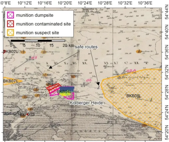
Figure 3: Section of a nautical chart of the western Baltic Sea, showing Kiel Bay and its munitions dumping grounds (munitions dumping grounds (pink); munitions-contaminated sites (red) and munitions suspected areas (orange)). The dumping ground Kolberger Heide (BKB04L) was mapped with multibeam during UDEMM surveys. The underlying map originates from 1923 and was used during WWII for navigation purposes. Last changes were made in 1945. The yellow dots indicate positions of navigation marks and light ships (Library of Mürwik Naval School; EGEOS, AmuCad).
6 https://udemm.geomar.de/home
In October 2018, the UDEMM consortium went on an additional cruise along the German Baltic coast with RV POSEIDON (cruise POS530 – MineMoni) and acquired a substantial set of water samples, dropped bio-monitoring moorings and used a high-resolution ship-based multibeam system and AUV- based camera observations to map selected areas in very high detail (Fehmarnsund and Bay of Lübeck;
Figure 3).
The sequence of the next subsections is organized in such a way as we believe a monitoring of a new, largely unknown area should be done. During UDEMM itself, we did not follow the best methodology structure, as the respective approaches still needed to be developed. At a late stage of the project, we further got in contact with Uwe Wichert (Consultant BLANO, MELUND and HELCOM SUBMERGED) who is an expert in WWI and WWII maritime war activities doing research in various archives in Germany and the UK. Through his expertise we realized that an in depth historical survey of the type of ammunition and their amounts that are/might be present in an area is of great importance for a better interpretation of results. It also allows for a better informed comparison between different areas and their joint impact on the environment.
2.1 History of the study area Kolberger Heide
Responsible institute: BLANO & GEOMAR Kampmeier et al. (in review) just recently presented an overview of the Kolberger Heide including its historical analyses. Documents of the provincial and federal archives in Schleswig and Freiburg (Germany) and the National Archive in Kew (UK) provide detailed information on the usage of the Kolberger Heide area in the past. With regards to war activities, the Kolberger Heide was firstly mentioned in the sea battle on 1 July 1644 during the Swedish-Danish war (1643-1645 CE). Before and during WWI, it was only used for commercial fishing, as it was too shallow for the German fleet to enter (Sections of nautical sea charts of the German Kriegsmarine, last changes in May 1945, Fachbibliothek Marineschule Mürwik). It is possible that 28 cm training grenades (steel housing without explosives) were introduced to the area during training exercises of the gun battery in Laboe. Apart from that, there are no records of additional munitions entering the area until WWII.
The first records from this period report the introduction of munitions in 1940, when the British Royal Air Force started bombing Kiel. Failed bombings, emergency overboard disposal and targeted attacks on vessels and watch units occurred along the Marine Traffic Route 1. This traffic route extended from Kiel to the eastern parts of the Baltic Sea (Figure 3) and was constantly surveyed and cleared by the German Kriegsmarine by mine clearing vessels and airborne mine clearing systems. It was the only ‘safe’ path vessels could use during times of war and was therefore an important target for the British Air Force.
However, the route was protected by German forces with onshore and vessel-based 12.8 cm anti- aircraft guns. A number of these shells ended up as unexploded ordnance (UXO) in Kiel Bay and also in the Kolberger Heide area. To obstruct vessel traffic, the British mined the Traffic Route 1, with as many as 3,896 British mines, also targeting the Kolberger Heide (British Mining Operations 1939 - 1945).
Because of the high number of mines and resulting losses, commercial fishing was prohibited in Kolberger Heide in 1942 (Bundesarchiv Militärarchiv Kriegstagebuch Sperrkommandant westliche Ostsee). Bombing and mining activities continued until the end of the war in May 1945. After the war,
UDEMM Practical Guide for Environmental Monitoring
of Conventional Munition in the Seas V1.1 December 2019
enormous quantities of captured arms and munitions were dumped into the sea, this was seen as the fastest and at that time safest method to secure and dispose of the weapons. The dumping grounds in German waters (North Sea and Baltic Sea) were chosen and approved on 29th July 1945, with Kolberger Heide mentioned as the first dumping ground (documents from the national archive of the UK in Kew).
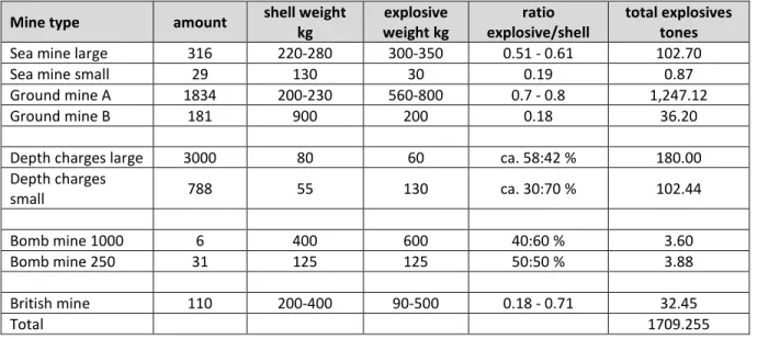
Following this decision, continuous sea-dumping of munitions occurred at Kolberger Heide. This included torpedo heads and mines from the torpedo arsenals in Schleswig-Holstein. Documents from the federal state of Schleswig-Holstein describe the dumping of about 24,000 metric tons of all kinds of munitions in Kolberger Heide. Adding torpedo heads and mines, about 30,000 t of munitions have to be assumed to be present at the site (Landesarchiv SL Akten des Kampfmittelräumdienstes). This includes an array of ammunition types ranging from gun and pistol cartridges, artillery projectiles consisting of grenades and propulsion cartridges, as well as anti-aircraft ammunition of 2 cm up to 40.6 cm calibre. In addition, the Kolberger Heide site most likely contains explosive charges such as anti-tank and anti- personnel mines, rifle grenades or bursting and hollow charges. Furthermore, bombs ranging from 1 kg up to 500 and 1.000 kg in weight, rockets with diameters of up to 32 cm, as well as marine munitions such as moored and ground mines, torpedo heads, whole torpedoes, and depth charges are present.
Some torpedoes that were formerly dumped in the area of Jägersberger Bridge were relocated to Kolberger Heide and re-dumped. Also, a barge loaded with 500 tons of chemical munitions (grenades of 10.5 and 15 cm calibre) were sunk in the Little Belt. According to records, it was recovered and re-sunk in the area of Kolberger Heide. In 1959, boxes with propellant charge powder stored on the upper deck of the barge were salvaged, until the chemical munitions were discovered. After that the chemical grenades were partially removed and the remainder relocated together with the barge to Geltinger Birk, where everything was encased in concrete and finally sunk in the North Atlantic (Landesarchiv SL Akten des Kampmittelräumdienstes).
As often when dealing with WWI and WWII dumped munition, the exact number and type of ammunition (and manufacturer) is unknown and therefore all common explosives and propellant charge powders used in WWII have to be assumed to be present at the Kolberger Heide site. This includes all sorts of filling powder, amatol, ammonite, ammonal, grenade filling 88 and marine explosives such as gun cotton (e.g. Schießwolle 36 and 39), special and testing explosives.
Since the munitions were manufactured from different kinds of material, it is not possible to predict the precise state of the munitions housings. Thin-walled moored mines and cartridges may already be heavily corroded, exposing explosive material to sea water; thick-walled artillery shells, bombs and ground mines may yet still be intact.
After WWII, the Allies intended to only dump defused munition; however it cannot be taken for granted that this was true for all dumped objects. Accidents including personal injuries and death occurred during the dumping work, and thus it needs to be assumed that at least some of the handled munitions were still armed. This is especially true for long-period delay detonators, mines with lead fuses or pendulum impact ignition.
Additional regions similar to Kolberger Heide were chosen as munitions dumping grounds by the Allies;
these include areas offshore Schönhagen and Falshöft in the Bay of Lübeck/Bay of Neustadt. It is also known that light-weight munitions like grenades were thrown overboard in Friedrichsort, Stollergrund, Strande Bay, and en route to these dumping grounds. These actions are indicated by findings of
fishermen and the EOD service (BLMP Bericht 2011 and Akten des Landesarchivs SL) and demonstrate the wide spread disposal of munitions in the south-western Baltic Sea that is now Germany territory.
Following WWII, Kolberger Heide was not used as a military training area anymore and is therefore not affected by contamination with further munitions. However, munitions that were subsequently found along marine traffic routes in Kiel Bay was defused and relocated to Kolberger Heide by the EOD service;
this practice is still ongoing and its results have been noticed during the UDEMM project by comparing multibeam maps acquired at different times.
Table 3 Amunition type and explosive weights for dumped munitions in Kolberger Heide.
Mine type amount shell weight kg
explosive weight kg
ratio explosive/shell
total explosives tones
Sea mine large 316 220-280 300-350 0.51 - 0.61 102.70
Sea mine small 29 130 30 0.19 0.87
Ground mine A 1834 200-230 560-800 0.7 - 0.8 1,247.12
Ground mine B 181 900 200 0.18 36.20
Depth charges large 3000 80 60 ca. 58:42 % 180.00
Depth charges
small 788 55 130 ca. 30:70 % 102.44
Bomb mine 1000 6 400 600 40:60 % 3.60
Bomb mine 250 31 125 125 50:50 % 3.88
British mine 110 200-400 90-500 0.18 - 0.71 32.45
Total 1709.255
2.2 Hydro-acoustic and visual mapping results
Responsible institute: GEOMAR As part of the scientific work in UDEMM, we tested two different kinds of state-of-the-art multibeam systems, a NORBIT iWBMS and a RESON T50. Both systems performed well with respect to their capacity, but most of the mapping finally occurred with the T50, which has a higher resolution (0.5°
along- and 1° across track). For high quality survey results, it was essential to properly reference all sensors to each other and use undisturbed RTK correction for the navigation. The presented results below have recently been submitted by Kampmeier et al. (in review).
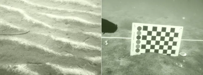
For the compilation of the entire Kolberger Heide area 20 d of surveying were needed (Figure 3), that were performed between 2016 and 2018. Repeating surveys in Nov. 2015, Feb. 2018 and June 2018 aimed at identifying potential migration of objects. The restricted dumping ground is located in the south of the area in 5 - 14 m water depth on a shallow platform, which towards the north develops into a more horizontal plain in 19 - 20 m water depth. Patches of algae, covering the seafloor with varying density could be observed in underwater video profiles and show seasonal variability in their spatial distribution. Small scale ripples of 5 cm height and 20 cm width indicate sediment transport on the seafloor. Their crests are generally N-S oriented and thus perpendicular to the bottom current direction (Figure 4).
UDEMM Practical Guide for Environmental Monitoring
of Conventional Munition in the Seas V1.1 December 2019
Figure 4 Left: a ripple field in Kolberger Heide. Right: Measuring the ripple height via a checker board.
The black and white squares are of 2 cm size each. The observed ripples are ca 5 cm high and up to 20 cm wide. Their symmetric shape rather point to wave induced ripples, rather than formed by currents.
In 19 m water depth in the outer area of the dumping ground, otter trawling marks are clearly visible inside the soft sediments and indicate significant fishing activities. This fishing method uses two boards that are dragged across the seafloor to keep the trawling net open. Since 2004, the trawling is prohibited in the Baltic Sea for areas more shallow than 20 m water depth or within 3 miles to the coastline. Despite the ban, 10 - 100 h of otter board trawling were noted within this area in 2006 (Sell et al., 2011). Even though Kolberger Heide is not one of the main fishing grounds in Kiel Bay, bottom trawling seems to occur close to the official dumping ground and thus can potentially lead to object displacement.
On local scale the bathymetry is characterized by a shallow platform, which extends from the shore and declines with a slope of less than 1° towards the north. It builds a plain in 19 m water depth. Patches that show increased rugosity (height differences of 2 - 4 cm) and ripple-like structures are present in the feature-scale morphology. Those areas produce high backscatter intensities and contain increased amounts of rocks. As the underwater environment of Kolberger Heide is strongly affected by anthropogenic use, artificial objects and remnants of activities are present on local and feature-scale.
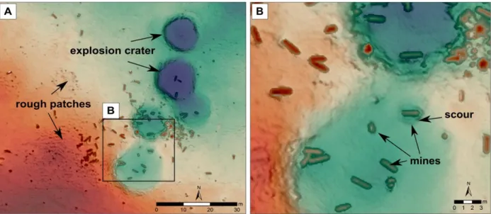
There are explosion craters with average diameters of 20 m and depths of 1.5 m, which can be observed as clusters or isolated craters across the entire study area. Craters were formed by in-situ destructions that partially acted as tests for bubble curtain experiments. Bubble curtains significantly decrease the sound energy of detonations and thus particularly protect marine mammals (Würsig et al., 2000).
Remnants of these bubble curtains in form of hoses and anchor stones were left on the seafloor; they can be reactivated if needed. Other types of feature-scale objects are all kind of UXO and dumped munitions in high numbers. Depending on the ammunition type, accurate identification is challenging to a varying degree. Three hot spot areas have been detected. The first area is composed of ~70 defused moored mines, piled up to a mound-like structure of 30 m length and 15 m width. Its height above the surrounding seafloor is about 1.5 m. The second highly contaminated area is located at a cluster of detonation craters (Figure 5). At this location around 90 munition objects of different types ranging from German and English ground mines over torpedo heads, water bombs to moored mines can be found.
Some of these objects have been brought to the dumping ground after being defused by the EOD service. The third area of around 150 m2 in size shows ca. 100 objects of 1 m by 0.6 m.
Initial validation dives identified these objects as aerial bombs, possibly fused. A high number of additional suspicious objects can be found all over the research area. Moored mines occur as spherical shaped objects with ca 1.2 m diameter all over the existing bathymetric data set. Due to their size and elongated shape, ground mines and torpedoes can be identified rather easily. Smaller objects such as bombs and torpedo heads are not as easily identified and require validation by divers or underwater video. Joint observation of derivatives with bathymetric data, can greatly enhance the speed of detecting and identifying munition objects. Slope, surface area and curvature highlight distinct objects as rocks and munitions on the seafloor very clearly (Figure 5).
Figure 5 A) The high resolution bathymetry reveals morphological features like five explosion craters of around 25 m diameter. Furthermore, differences in the seafloor texture like patches of increased rugosity are visible. B) Close-up of ground mines in and around explosion craters (feature scale).
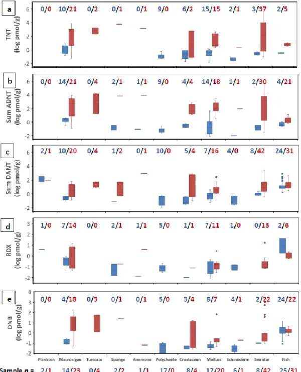
2.3 Munitions compounds in water, sediment and biota
Responsible institute: GEOMAR Dissolved MC in the water column: Dissolved MCs were detectible in nearly all water column samples collected during the UDEMM project. Concentrations showed a range nearly exceeding nine orders-of- magnitude (Figure 6), most likely due to rapid mixing and dilution. Most of the samples showed TNT concentrations on the order of 1-10 pM, highlighting the critical need to use ultra-sensitive detection methods such as those developed during UDEMM. Previous results showed that MC distributions in the water column were highly variable in both space and time and that high resolution sampling is required to adequately monitor the regional magnitude and extent of contaminant plumes from underwater munitions dumping grounds. As a result, the sample collection and processing method that had been developed earlier during UDEMM (and published in Gledhill et al., 2019) were modified to reduce processing time and facilitate higher frequency sampling (see Section 4.7).
UDEMM Practical Guide for Environmental Monitoring
of Conventional Munition in the Seas V1.1 December 2019
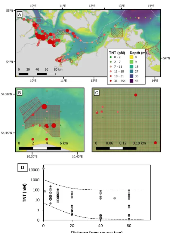
Figure 6: A) Regional-scale distribution of dissolved TNT in bottom waters throughout the south-western German Baltic Sea. B) Wide-local scale of dissolved TNT in bottom waters at Kolberger Heide. C) Narrow- local scale view of the cluster of overlapping points at centre in B. D) Feature-scale gradients within 1 m of munitions surfaces. Symbol colour and size in A-C) indicate concentration. Shading and marker line colour in D) distinguishes among 17 individual sample sets. Data shown in A-C) includes samples collected in October 2017 and 2018. Data in D) are redrawn from Beck et al. (2019) and include March, June, and October 2017. Additional data in D) are from October 2018. Note that the units in D) are on a log-scale and are 1000-fold higher than in A-C).
At the regional scale (Figure 6A), clear gradients were evident in TNT concentration. Areas with munitions dumping ground (e.g., Kolberger Heide; Bay of Lübeck) or known munitions contamination tended to show the highest concentrations (up to 354 pM for TNT). Nonetheless, there were marked differences among dumping ground, illustrated by the nearly order-of-magnitude difference between maximum concentrations observed in October 2018 in Kolberger Heide (354 pM) compared with the Bay of Lübeck (43 pM). This is the case, despite estimates that the Bay of Lübeck contains about double the amount present in Kolberger Heide (Böttcher et al., 2011). TNT concentrations were lowest in the Arkona Basin and the Mecklenburg Bight, likely as a result of their deeper water column and greater distance from munitions sites. Water exchange through the central channel and Belt Sea (north and northeast of Fehmarn) dilutes contamination originating close to coastlines, although samples collected north and northeast of Fehmarn showed substantial TNT enrichment.
The widespread presence of munitions on the Baltic seafloor make it challenging to link specific MC sources to plumes of dissolved MCs in the water column. Elevated concentrations oberved in the far western basin, and the wide dispersion of MCs on wide local scales (Figure 6B) imply long-range transport of MCs. This must occur on relatively short time scales, before loss by microbial or abiotic degradation or sorption and sedimentation with particles occur.
Loss of MCs through mechanisms such as degradation or sorption is likely to depend on site-specific characteristics such as temperature and salinity. Evaluating the impact of MC release on ecological systems requires constraint of potential long-range transport and chemical residence times. A number of simple experiements were conducted during UDEMM (see below) to provide an approximation of these controls and a quantitative constraint for modelling purposes.
On the local scale (0.05 - 5 km) in Kolberger Heide, water column TNT distributions show some indication of gradients around known munitions hotspots (Figure 6 and Figure 7). A general east-west increase in concentration cross the entire Kolberger Heide site may reflect enrichment of water traveling along the predominant current direction (Figure 7B. However, on the small local scale (10s to 100s of meters), gradients seem to be smoothed out by water mixing. For example, nine samples collected within 200 m around a pile of some 70 - 90 sea mines show no clear gradient in dissolved TNT (Figure 7c, Figure 8). This suggests that on such spatial scales, mixing is rapid relative to both input from the munitions source as well as removal mechanisms such as degradation.
A variety of explosive compounds in an even more extensive array of explosive mixtures exist, with more than 500 formulations manufactures (Haas and Thieme, 1996). Most organic explosives also undergo degradation or transformation to daughter compounds. Many of these daughter compounds are equally or more toxic than the parent, or toxicity is unknown. Such alteration can occur on a time scale of hours to days. It may thus be possible to have high influx, but low water column inventories of the parent MC.
Monitoring only the parent MCs would underestimate the total chemical release. This emphasises the importance of multi-compound chemical analyses for evaluating chemical emission from underwater munitions.
The method developed during UDEMM (Gledhill et al., 2019) targets 17 compounds, including both a variety of explosives as well as several daughter product compounds. This was important, to elucidate chemical release trends across all spatial scales.
UDEMM Practical Guide for Environmental Monitoring
of Conventional Munition in the Seas V1.1 December 2019
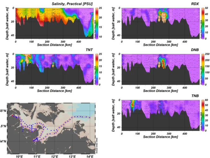
Figure 7. Sections showing the regional MC distribution with depth along the nearshore cruise track of POS530 highlighted in red (October 2018). The Kolberger Heide (located at ~75 km) and the Bay of Lübeck (at ~250 km) are particular focal points of the MC load. Black dots show the positions of the individual samples used for contouring. TNT = Trinitrotoluene, RDX = Hexogen, DNB = Dinitrobenzene, TNB = Trinitrobenzene.
At the regional scale, major differences were observed in the abundance of different explosive compounds. One of the most obvious difference was evident between Kolberger Heide and the Bay of Lübeck. The Bay of Lübeck is posited to have nearly double the quantity of munitions compared with Kolberger Heide (Böttcher et al., 2011). Dissolved TNT concentrations were nonetheless eight-fold lower in the Bay of Lübeck (43 vs. 354 pM; Figure 7). In contrast, the explosive compounds RDX and DNB were more than 30-fold higher in the Bay of Lübeck compared to Kolberger Heide. This suggests a major difference in the type of explosives dumped at the two sites. Whereas TNT inventories indicate lower MC contamination in the Bay of Lübeck, DNB and RDX suggest a contrary situation. Monitoring that targets only individual compounds can lead to vastly differing conclusions on the extent of explosives contamination.
At the feature scale, in situ benthic chamber incubations of individual exposed explosive solids at Kolberger Heide revealed clear compositional differences. The ratio of TNT, RDX and DNB released from three separate solids showed order-of-magnitude differences (Figure 8). This suggests that there is