)RUVFKXQJVVFKLII
0(7(25
5HLVHQ1U0±0
±
0HWDOODEODJHUXQJHQXQG5RKVWRIISRWHQWLDODPODQJVDPVSUHL]HQGHQ7$*
6HJPHQW10$5±%OXH0LQLQJ#6HD
'LH(QWVWHKXQJXQG(QWZLFNOXQJR]HDQLVFKHU3ODWHDXVDP%HLVSLHOGHU
$]RUHQ3RUWXJDO±$]RUHQ3ODWHDX
'LH5ROOHGHU%DQFG¶$UJXLQXQGGHU6LQH6DORXPDOV
6HGLPHQWDWLRQVEHFNHQXQG4XHOOHIUGLH3URGXNWLYLWlWLPVGOLFKHQ .DQDUHQVWURP±%$66
+HUDXVJHEHU
,QVWLWXWIU0HHUHVNXQGH8QLYHUVLWlW+DPEXUJ /HLWVWHOOH'HXWVFKH)RUVFKXQJVVFKLIIH
KWWSZZZOGIXQLKDPEXUJGH
*HI|UGHUWGXUFK
'HXWVFKH)RUVFKXQJVJHPHLQVFKDIW')*
%XQGHVPLQLVWHULXPIU%LOGXQJXQG)RUVFKXQJ%0%)
,661
)RUVFKXQJVVFKLII5HVHDUFK9HVVHO
0(7(25
5HLVHQ1U0±0&UXLVHV1R0±0
±
0HWDOODEODJHUXQJHQXQG5RKVWRIISRWHQWLDODPODQJVDPVSUHL]HQGHQ7$*6HJPHQW
10$5
0HWDOIOX[HVDQGUHVRXUFHSRWHQWLDODWWKHVORZVSUHDGLQJ7$*PLGRFHDQULGJHVHJPHQW
10$5±%OXH0LQLQJ#6HD
'LH(QWVWHKXQJXQG(QWZLFNOXQJR]HDQLVFKHU3ODWHDXVDP%HLVSLHOGHU$]RUHQ 3RUWXJDO
7KHIRUPDWLRQDQGHYROXWLRQRIRFHDQLFSODWHDXVDFDVHVWXG\IURPWKH$]RUHV3RUWXJDO±
$]RUHV3ODWHDX
'LH5ROOHGHU%DQFG¶$UJXLQXQGGHU6LQH6DORXPDOV6HGLPHQWDWLRQVEHFNHQXQG 4XHOOHIUGLH3URGXNWLYLWlWLPVGOLFKHQ.DQDUHQVWURP
7KHUROHRIWKH%DQFG¶$UJXLQDQG6LQH6DORXPDVVLQNIRUPDWWHUIOX[HVDQGVRXUFHIRU SURGXFWLYLW\RIWKHVRXWKHUQ&DQDU\&XUUHQWV\VWHP±%$66
+HUDXVJHEHU(GLWRU
,QVWLWXWIU0HHUHVNXQGH8QLYHUVLWlW+DPEXUJ /HLWVWHOOH'HXWVFKH)RUVFKXQJVVFKLIIH
KWWSZZZOGIXQLKDPEXUJGH
*HI|UGHUWGXUFK6SRQVRUHGE\
'HXWVFKH)RUVFKXQJVJHPHLQVFKDIW')*
%XQGHVPLQLVWHULXPIU%LOGXQJXQG)RUVFKXQJ%0%)
,661
Anschriften / Addresses
Dr. Sven Petersen Telefon: +49-431-600-2110 Helmholtz-Zentrum für Ozeanforschung Kiel Telefax: +49-431-600-2924
Ostufer e-mail: spetersen@geomar.de
Wischhofstr. 1-3 24148 Kiel / Germany
PD. Dr. Christoph Beier Telefon: +49 9131 85-26064 GeoZentrum Nordbayern Telefax: +49 9131 85-29295 Universität Erlangen-Nürnberg e-mail: christoph.beier@fau.de Schloßgarten 5
91054 Erlangen / Germany
Dr. Werner Ekau Telefon: +49 421 2380023
Leibniz-Zentrum für Marine Tropenökologie Telefax: +49 421 2380030
Fahrenheitstr. 6 e-mail: werner.ekau@leibniz-zmt.de
28359 Bremen
Leitstelle Deutsche Forschungsschiffe Telefon: +49-40-428-38-3640 Institut für Meereskunde Telefax: +49-40-428-38-4644
Universität Hamburg e-mail: leitstelle@ifm.uni-hamburg.de Bundesstraße 53 http: www.ldf.uni-hamburg.de D-20146 Hamburg
Reederei
Briese Schiffahrts GmbH & Co. KG Telefon: +49 491 92520 160 Abt. Forschungsschifffahrt Telefax +49 491 92520 169 Hafenstrasse 6d (Haus Singapore) e-mail: research@briese.de
26789 Leer http: www.briese.de
Senatskommission für Ozeanographie Telefon: +49-421-218-65500 der Deutschen Forschungsgemeinschaft Telefax: +49-421-218-65505 Vorsitzender: Prof. Dr. Michael Schulz e-mail: SeKom.Ozean@marum.de MARUM, Universität Bremen
Leobener Strasse 28359 Bremen
3
Forschungsschiff / Research Vessel METEOR
Vessel’s general email address meteor@meteor.briese-research.de Crew’s direct email address n.name@meteor.briese-research.de
Scientific general email address chiefscientist@meteor.briese-research.de Scientific direct email address n.name@meteor.briese-research.de
Each cruise participant will receive an e-mail address composed of the first letter of his first name and the full last name.
Günther Tietjen, for example, will receive the address:
g.tietjen@meteor.briese-research.de Notation on VSAT service availability will be done by ship’s management team / system operator.
• Data exchange ship/shore : on VSAT continuously / none VSAT every 15 minutes
• Maximum attachment size: on VSAT no limits / none VSAT 50 kB, extendable on request
• The system operator on board is responsible for the administration of all email addresses
Phone Bridge (Iridium Open Port) +881 677 701 858
(VSAT) +49 421 98504370
Phone Chief Scientist (Iridium Open Port) +881 677 701 859 (VSAT) +49 421 985 04372
4
METEOR Reisen / METEOR Cruises M127 – M129
25. 05. 2016 – 22. 08. 2016
Metallablagerungen und Rohstoffpotential am langsam spreizenden TAG Segment (26°N, MAR
Metal fluxes and resource potential at the slow-spreading TAG mid-ocean ridge segment (26°N, MAR) – Blue Mining @ Sea
Die Entstehung und Entwicklung ozeanischer Plateaus am Beispiel der Azoren, Portugal
The formation and evolution of oceanic plateaus, a case study from the Azores, Portugal – Azores Plateau
Die Rolle der Banc d’Arguin und der Sine Saloum als Sedimentations-becken und Quelle für die Produktivität im südlichen Kanarenstrom
The role of the Banc d’Arguin and Sine Saloum as sink for matter fluxes and source for productivity of the southern Canary Current system – BASS
Fahrt / Cruise M127 25.05.2016 – 28.06.2016
Bridgetown (Barbados) – Ponta Delgada (Azoren) Fahrtleiter / Chief Scientist: Dr. Sven Petersen
Fahrt / Cruise M128 02.07.2016 – 24.07.2016
Ponta Delgada (Azoren) – Ponta Delgada (Azoren) Fahrtleiter / Chief Scientist: PD. Dr. Christoph Beier
Fahrt / Cruise M129 27.07.2016 – 22.08.2016
Ponta Delgada (Azoren) – Mindelo (Kapverden) Fahrtleiter / Chief Scientist: Dr. Werner Ekau
Koordination / Coordination Leitstelle Deutsche Forschungsschiffe
Kapitän / Master METEOR M127: Rainer Hammacher M128-129: Michael Schneider
5
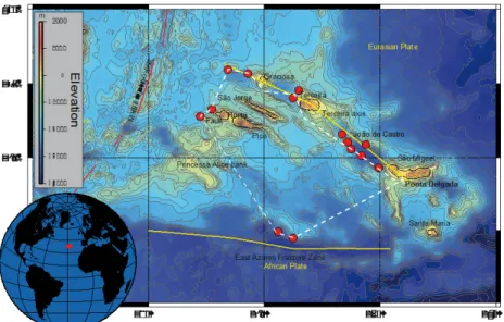
Abb. 1 Geplante Fahrtrouten und Arbeitsgebiete der METEOR Expeditionen M127 – M129.
Fig. 1 Planned cruise tracks and working areas of METEOR cruises M127 – M129.
M127
M128
M129
6
Wissenschaftliches Programm
Scientific Programme Fahrt / Cruise M127 – M129
Übersicht Fahrt M127
Marine Massivsulfide gelten gemeinhin als ein möglicher Baustein in einer zukünftigen sicheren globalen Rohstoffversorgung. Die Abschätzung des Rohstoffpotentials ist aber ohne die Beantwortung einiger fundamenta- ler Fragen kaum möglich. So liegen derzeit mehrere Größenordnungen in den Mengen- abschätzungen, die auf Beobachtungen am Meeresboden beruhen und theoretischen Überlegungen. Um die Diskrepanz aufzulö- sen, müssen wir verstehen, wieviel von dem Metall, das durch hydrothermale Konvekti- on am mittelozeanischen Rücken freigesetzt wird, über geologische Zeiträume als Sulfid abgesetzt wird. Zudem zielen derzeitige Ex- plorationsmethoden meist nur auf aktive, junge Hydrothermalsysteme.
Es wird vermutet, dass 10 mal mehr Metall in inaktiven Vorkommen enthalten ist, für dessen Suche aber bis vor kurzem die nöti- gen Technologien fehlten. Im Rahmen des EU-FP7 Projektes „Blue Mining“ werden solche Verfahren entwickelt. Durch die Nut- zung dieser neuen Technologien während M127 können wir zum ersten Mal das wahre Rohstoffpotential eines langsam-spreizenden mittelozeanischen Rückensegmentes be- stimmen. Aufgrund des Auftretens von akti- ven wie auch inaktiven Sulfidhügeln sowie Hinweisen auf weitere Vorkommen in der Umgebung ist das TAG Segment (26°N) für die Untersuchung bestens geeignet.
Fahrt M128
Die Entstehung ozeanischer Plateaus und ihre strukturelle, petrologische und geoche- mische Entwicklung sind bisher nur unzu- reichend verstanden. Im Zuge der Fahrt M128 und in Kombination mit den geophy- sikalischen Daten der Ausfahrt M113 soll die Entstehung und Entwicklung des Azoren
Synopsis Cruise M127
Submarine massive sulfide deposits are of- ten seen as a possible future contribution to a secure metal supply for global human needs. Resource estimates, however, are lacking several of the fundamental answers that need to be addressed. There are cur- rently several orders of magnitude between resources estimates based on observations at the seafloor and those based on metal fluxes. We need to understand how much of the metal that is released by high- temperature fluid convection over a given length of a ridge axis and over a specific geological time frame is actually deposited as massive sulfides. Additionally, explora- tion is currently only targeting active depos- its.
It is assumed that 10 times more inactive massive sulfides are occurring within the neovolcanic zone, but until recently the technology to identify those deposits was lacking thereby underestimating the global resource potential. Within the framework of the EU-FP7 project “Blue Mining” some of these limitations are addressed and this pro- vides us with the tools to address, for the first time, the full metal potential and fluxes of a slow-spreading mid-ocean ridge. Inves- tigations will be targeted at the TAG seg- ment (26°N, Mid-Atlantic Ridge) where ac- tive and a few inactive massive sulfide de- posits are known, but the majority of the segment has never been investigated.
Cruise M128
The Formation of oceanic plateaus and their structural, petrological and geo-chemical evolution remain poorly constrained. Dur- ing Cruise M128 we will investigate the formation and evolution of the Azores Plat- eau by means of rock sampling and com- bined these with geophysical data and tec- 7
Plateaus untersucht werden. Ziel dieser Fahrt ist es, die älteren, tieferen Bereiche des submarinen Plateaus und die jüngeren, aktiven submarinen Vulkane im Norden des Plateaus mittels ROV MARUM-Quest, TV- Greifer und Vulkanitstoßrohr zu beproben.
Diese Daten werden einen wesentlichen Beitrag zum Verständnis der Entwicklung dieses submarinen Plateaus, von seinem frühesten Bildungsstadium bis zu den jüngs- ten, aktiven Vulkanen leisten. Der junge, hydrothermal aktive Seamount João de Cast- ro zwischen den beiden Inseln São Miguel und Terceira wird zudem Gegenstand um- fangreicher biologischer und hydrothermaler Beprobung sein, um detaillierte Informatio- nen über die Zusammensetzung des hydro- thermalen Systems und die damit assoziier- ten biologischen Lebensgemeinschaften zu bekommen. Zusätzlich werden die jüngeren Vulkane westlich ausgewählter Azorenin- seln auf das Vorkommen weiterer, unbe- kannter Hydrothermalquellen untersucht werden. Die Ergebnisse dieser Fahrt, kom- biniert mit den geophysikalischen Daten und tektonischen Modellen der Fahrt M113, werden erstmals ein umfassendes Bild der strukturellen und geologischen Entwicklung des Azoren Plateaus geben.
Fahrt M129
Das marine Ökosystem auf dem Schelf im Auftriebsgebiet vor Mauretanien und Sene- gal ist wissenschaftlich wie ökonomisch von großem Interesse.
(1) Es ist als am stärksten eutrophiertes re- gionales tropisches Ökosystem, das zudem von CO2-reichen Auftriebswasser beein- flusst wird, ein Beispiel mit Lehrbuchcha- rakter für natürliche Eutrophierung und Ozeanversauerung und ein herausragendes Vorhersageszenario für erwartete zukünftige Veränderungen der Meere.
(2) Es ist eines der produktivsten Fischerei- gebiete unserer Erde, das gleichzeitig exem- plarisch die dramatischen Folgen von Über- fischung zeigt.
(3) Es deckt einen ozeanographischen Über- gangsbereich ab, der erlaubt, die Einflüsse der verschiedenen Parameter zu entschlüs- seln. Die hier vorgeschlagene ökologisch-
tonic models from Cruise M113. The main aim of this cruise is the sampling of the old- er, deeper sections of the submarine Plateau and the younger, active submarine volca- noes by ROV MARUM-Quest, TV-Grab and wax corer.
The combined data will allow to better con- strain the evolution of the submarine Plat- eaus from its earliest formation stages to the youngest, active volcanoes. In addition, we will intensely sample the young, hydrother- mally active seamount João de Castro, lo- cated between the islands São Miguel and Terceira, for hydrothermal and biological samples to increase our information on the composition of the hydrothermal system and the associated biological vent communities.
The results from this cruise along with the geophysical data and tectonic models from cruise M113 will, for the first time, provide a comprehensive structural and geological picture of the evolution of the Azores Plat- eau.
Cruise M129
The marine ecosystem on the shelf in the upwelling off Mauritania and Senegal is scientifically as well as economically of great interest:
(1) As the most highly eutrophic regional tropical ecosystem worldwide, which additionally is strongly affected by the CO2- enriched upwelled waters, it represents a textbook example of natural eutrophication and acidification; it is a future scenario for the changes expected for the future seas.
(2) It is one of the most productive fisheries grounds of the earth that at the same time shows severe consequences of overfishing.
(3)The proposed ecological-biological expedition will focus on biogeochemical processes, trophic networks, and productivity and the interaction between 8
biologische Expedition soll biogeochemi- sche Prozesse, trophische Netze und Produk- tivität entschlüsseln. Der Austausch zwi- schen Flachwasser, Schelf und offenem Ozean steht im Zentrum der hier vorge- schlagenen Untersuchungen.
shallow waters, the shelf, and the open ocean.
9
Von /From Bridgetown – Nach /To Pt. Delgada Fahrt / Cruise M127
Wissenschaftliches Programm
An dem langsam spreizenden Mittelozeani- schen Rücken bilden sich oft relativ große, submarine Massivsulfidablagerungen. Das TAG Segment bei 26°N auf dem langsam- spreizenden Mittelatlantischen Rücken (MAR) besteht z.B. aus einem aktiven sowie mehreren inaktiven Sulfid-Ablagerungen, wobei der Großteil des Segments bisher noch nicht untersucht wurde. Detaillierte, hochauflösende Kartierungen eines großen Teils des Rückensegmentes mit einem auto- nomen Unterwasserfahrzeug (AUV), seis- mische Untersuchungen mit Streamern und Ozeanbodenseismometern (OBS) sowie Un- tersuchungen an Sedimentkernen erlauben uns nun erstmalig, folgende Fragestellungen zu beantworten:
1) Mit welcher Rate akkumulieren Massiv- sulfide am langsam spreizenden Rücken und wie verändert sich diese Rate mit der Zeit?
2) Welche räumlichen regionalen und lokalen Faktoren beeinflussen die Lage dieser großen Hydrothermalfelder?
3) Wie ist das Mengenverhältnis zwischen aktiven und inaktiven Ablagerungen am langsam spreizenden Rücken?
4) Wie weit außerhalb der Rückenachse (bzw. zurück in der Zeit) können wir hy- drothermale Aktivität mit geophysika- lischen- und chemischen Methoden (AUV-basierte Studien plus Sediment- chemie) nachweisen?
In Bezug zum übergeordneten EU-FP7- Projekt „Blue Mining: Breakthrough Solu- tions for the Sustainable Deep Sea Mining Value Chain“ wird sich die Ausfahrt M127 darüber hinaus mit folgenden technischen Neuentwicklungen beschäftigen:
1) Erprobung AUV-basierter Eigenpo- tentialsensoren für die Exploration inaktiver Ablagerungen (eSMS).
Scientific Programme
Slow-spreading mid-ocean ridges are known to host accumulations of large submarine massive sulfide (SMS) deposits. The TAG Hydrothermal field at 26°N on the Mid- Atlantic Ridge, for instance, is characterized by a large active black smoker complex and by several similar-sized inactive (eSMS) sites, despite the fact that only small areas of this ridge segment were ever investigated.
Detailed high-resolution AUV-based map- ping on a segment scale combined with 2D- 3D seismic observations and the investiga- tion of surface sediments will allow us, for the first time, to address the following scien- tific questions:
1) What is the accumulation rate of sul- phide formation at a slow-spreading ridge and how does it change over time?
2) What are the regional and local spatial controls of these large hydrothermal fields?
3) What is the proportion between active and inactive deposits at a slow- spreading ridge?
4) How far out (back in time) can we trace hydrothermal activity using geo- physical and geochemical instrumenta- tion (AUV-based surveys plus sediment geochemistry)?
Addressing the EU-FP7-project ‘Blue Min- ing: Breakthrough Solutions for the Sustain- able Deep Sea Mining Value Chain’, cruise M127 aims at the following specific objec- tives regarding recent technological devel- opments:
1) Test of AUV-based self-potential sensor package for use in explora- tion of inactive sulphide occurrences (eSMS).
10
2) Erstellung regionaler, hochauflösender Karten, die die geochemischen Unter- suchungen von oberflächennahen Se- dimenten (Deckschicht) zur Identi- fizierung von verborgener Sulfidmine- ralisation unterstützen.
3) Bereitstellung hochauflösender geo- physikalischer Querschnitte (2D / 3D- Seismik und Sedimentecholot) von charakteristischen eSMS-Beispielen.
4) Erstellen hochauflösender Fotomosa- ik-Karten zur Einschätzung der Bereiche, die durch mögliche Abbau- aktivitäten beeinflusst werden könnten (in Kooperation mit dem EU-FP7- Projekt “MIDAS“).
Arbeitsprogramm
Im Laufe der Ausfahrt M127 werden insge- samt 11 AUV Tauchgänge um den aktiven TAG Hügel sowie den zwei inaktiven Fel- dern der Alvin und Mir Zone durchgeführt, wobei Bathymetrie, Magnetik und elektro- chemische Sensoren genutzt werden, um inaktive Sulfidablagerungen zu identifizie- ren.
Das AUV Abyss (GEOMAR), ausgestattet mit einem RESON 7125 Fächerecholot, sammelt topographische und Rückstreudaten im sub-Meter Bereich, die zudem Rück- schlüsse auf Sedimentbedeckung und relati- ves Alter von Lavaströmen zulassen.
Zeitgleich mit dem Fächerecholot, misst ein 3-achsiges APL 1540 Fluxgate Magnetome- ter magnetische Anomalien, wobei negative Werte auf Spuren hydrothermaler Alteration hindeuten.
Ein elektrochemischer (Eigenpotential) Sen- sor, der im Rahmen des Blue Mining Projek- tes entwickelt wurde, soll geochemische Anomalien aufzeigen, die aufgrund von Oxidationsprozessen auf inaktive SMS Ab- lagerungen hinweisen.
Ein zusätzlicher AUV Tauchgang erstellt ein Fotomosaik, das für Habitatkartierungen und Identifikation hydrothermaler Einflussradien benutzt wird.
Das Sedimentecholot wird in einem weite- ren Tauchgang auf seine Fähigkeit, verdeck- te SMS Ablagerungen zu detektieren, getes- tet.
2) Produce regional, high-resolution maps to aid a geochemical study of surface sediments (cover rocks) to identify concealed sulfide minerali- zation.
3) Provide high-resolution geophysical sections (2D / 3D-seismic and sub- bottom profiling) across type exam- ples of eSMS.
4) Provide high-resolution photomosa- ics of SMS to aid recognition of are- as of potential marine mining impact (in cooperation with the EU-FP7- project “MIDAS”).
Work Programme
During M127, 11 AUV dives will be con- ducted around the TAG active mound, and the two fossil mounds of the Alvin and Mir Zone using bathymetry, magnetics and elec- trochemical sensors to identify inactive sul- fide deposits.
The AUV Abyss (GEOMAR) is equipped with a RESON 7125 multi-beam system, acquiring topographic and backscatter data in sub-meter resolution, which also provides additional bottom information as sediment cover and relative ages of lava flows.
An APL 1540 3-axis fluxgate magnetometer is deployed during multibeam surveys on an outrigger, and is used to identify areas of past hydrothermal alteration (magnetic lows).
An electrochemical (self-potential) sensor that is developed within the Blue Mining Project and will be tested during M127, rec- ords geochemical anomalies related to oxi- dation of inactive SMS deposits.
One additional AUV dive is devoted to a photogrammetric survey for habitat map- ping and identifying hydrothermal halos around (e)SMS deposits.
The sub-bottom profiler sensor is used in another dive to test its capability to detect massive sulfides under sediment cover.
11
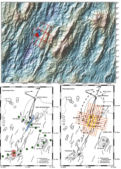
Abb. 2 Oben: Bathymetrie des Arbeitsgebietes bei 26°N (MAR) mit aktivem TAG Hydrother- malfeld (roter Punkt) und inaktiven Ablagerungen der fossilen Alvin und Mir Zonen (blaue Punkte). Die roten Rechtecke markieren Gebiete für insgesamt 11 AUV-Tauchgänge. Quelle:
GeoMapApp. Unten links: Geplante Foto-Tauchfahrt (roten Linien) und Sedimentecholotprofile (blaue Linien), sowie Schwerelotstationen (grüne Punkte) im Zentralbereich des Arbeitsgebie- tes. Unten rechts: Geplante OBS Anordnung (gelbe Punkte) und Fahrtrouten für tief geschlepp- te Multichannel Streamer Seismik (rote Linien).
Fig. 2 Top: Bathymetry of the working area at 26°N (MAR) with location of the active TAG mound (red dot) and inactive SMS of the relict Alvin and Mir Zones (blue dots). Red boxes denote 11 planned AUV dive areas. Source: GeoMapApp. Bottom left: planned location of pho- to-survey (red lines) and sub-bottom profiler survey (blue lines), while green dots denote grav- ity coring stations in the central part of the working area. Bottom right: planned OBS loca- tions (yellow dots) and deep towed multichannel streamer survey (red lines).
Die seismischen Untersuchungen zielen auf eine Interpretation der OBS Daten in 3D für die eSMS und ihre nahe Umgebung. Das Netzwerk umfasst ca. 25 OBS Stationen, die basierend auf den hochauflösenden AUV
The seismic survey will be designed to enable an interpretation of the OBS data in 3D of the eSMS deposits and its surroundings. The network of approx. 25 OBS stations will be positioned based on high-resolution AUV 12
Karten geplant werden und mit dem fernge- steuerten HyBIS RUV ausgebracht werden.
Abweichungen der Positionen und Messun- gen werden überwacht durch Videoaufnah- men während des Aussetzens, USBL Posido- nia, sowie durch Ersteinsätze von Luftkano- nenschüssen. Das geplante Luftkanonen Pro- fil sowie der tief geschleppte multichannel Streamer werden entsprechend der OBS Netzwerkegeometrie angepasst. Neben den OBS-Stationen werden 6 elektromagnetische Stationen (OBEM) im Vorfeld der For- schungsfahrt JC138 mit RV James Cook aus- gesetzt (Juli-August 2016).
Zusätzlich werden ca. 24 Schwerelotstatio- nen, angeordnet in zwei Traversen über zwei bekannte eSMS Strukturen, jeweils die ersten 1-3 m Sedimentbedeckung (abhängig von der Sedimentmächtigkeit) beprobt. An Bord werden mineralogische und geochemische Schnellverfahren (z.B. PIMA, tragbare Ra- man, tragbare XRF) auf ihre Tauglichkeit zur schnellen Exploration – ein Hauptziel des EU-FP7-Projektes Blue Mining – getestet.
Diese Messungen sollen, in Kombination mit den AUV Karten, eine schnellere Einordnung von Explorationskriterien und im Idealfall die Definition von Gebieten mit hohen Er- folgsaussichten auf die Entdeckung von eSMS Ablagerungen erlauben (schon wäh- rend der Ausfahrt). Sedimente und Poren- wässer werden zudem für zusätzliche Mes- sungen an Land vorbereitet, wie z.B. Mes- sung der chemischen Zusammensetzung der Minerale sowie ihre Isotopensignatur, um die Variabilität des Metalleintrags über die Zeit zu bestimmen.
Revierfahrten werden zur Kartierung mit dem Schiffsfächerecholot EM122 genutzt.
bathymetry, and actively deployed using the remotely controlled HyBIS RUV deployment frame. Instrument offsets and seafloor posi- tion can be checked by video footage during deployment, USBL records, and through first arrival of airgun shots. The layout of the air- gun profiles and deep towed multichannel streamer will be adapted to accommodate the final OBS network geometry. Next to the OBS-stations 6 passive electromagnetic (OBEM) stations will be deployed for the immidiately following cruise JC138 with RV James Cook (July – August, 2016).
Additionally, a total of 24 gravity core sta- tions are planned that will sample the first 1- 3 m of sediment cover (depending on the sed- iment thickness) along two traverses, each across known eSMS. On-board mineralogical and geochemical analysis will test the use of certain instruments (e.g. PIMA, portable Raman, portable XRF) for rapid exploration – a major goal of the EU-FP7-Project Blue Mining. Those measurements, in combination with AUV maps, will allow a fast ranking of exploration criteria, ideally providing maps indicating sectors with a high success rate of finding eSMS already during the cruise. Sed- iments and pore waters are prepared for ad- ditional shore-based investigations, such as the chemical compositions of minerals and their isotope signature, to assess the variabil- ity of metal input over time.
Transit times between stations will be used to acquire multibeam data with the EM122.
13
Zeitplan / Schedule Fahrt / Cruise M127
Tage/days Auslaufen von Bridgetown (Barbados) am 25.05.2016
Departure from Bridgetown (Barbados) 25.05.2016
Transit zum Arbeitsgebiet / Transit to working area (mit/with EM122) 5 Bathymetrische AUV-Kartierung, Profile (5 Tauchgänge á 24 Std., plus Ladevorgang) 8 Bathymetric AUV-mapping, main transects (5 dives @ 24 hours, plus charging)
AUV Foto-Tauchfahrt, Hauptfeld (1 Tauchgang) 1
AUV Foto survey, main field (1 dive)
DTMCS, Alvin Zone, 3500 m Tiefe / DTMCS, Alvin zone, 3500 m depth 5 (6 km wire @ 0.5 m/s = 3.5 hrs; sail @ 3 kn, turn 3.5 hrs; 16 profiles, 10 nm = 110 hrs) Bathymetrische AUV-Kartierung, Außenbereich (6 Tauchgänge, plus Ladevorgang) 9 Bathymetric AUV-mapping, outer zone (5 dives @ 24 hours, plus charging)
AUV Sedimentecholot, Alvin Zone (1 Tauchgang) 1
Near-bottom sub-bottom profiler survey, Alvin Zone (1 dive)
Transit zum Hafen Ponta Delgada / Transit to port Ponta Delgada (mit/with EM122) 5 Total 34 Einlaufen in Ponta Delgada (Azoren) am 28.06.2016
Arrival in Ponta Delgada (Azores) 28.06.2016
Während AUV Tauchgängen (ohne zusätzliche Schiffszeit) / during AUV dives (no additional shiptime needed):
OBS Aussetzen, Alvin Zone (20 Stück, während ersten AUV Tauchgängen) 3 OBS deployment, Alvine zone (20 stations, during first few AUV dives)
Schwerelot (24 Stationen á 2 * 3500 m @ 0,7 m/s = 3 Std.) 3 Gravity coring (24 stations; 2 * 3500 m @ 0.7 m/s = 3 hrs)
OBS Einholen (während der letzten AUV Tauchgänge; 25 Stück á 40 min Aufstieg und
30 min Aufnahme) 1
OBS recovery (during last AUV dives; 25 stations @ 40 min rise, 30 min pickup)
14
Von /From Ponta Delgada – Nach /To Ponta Delgada Fahrt / Cruise M128 Wissenschaftliches Programm
Das Arbeitsprogramm der Ausfahrt M128 wird sich aus einer Kombination von geo- physikalischen (Multibeam, parametrische Sedimentecholot-Messung), geologischen (ROV MARUM-Quest, TV-Greifer, Vulka- nitstoßrohr, MAPR) und biologischen (ROV MARUM-Quest, CTD) Methoden zusam- mensetzen. Das Arbeitsprogramm ist darauf ausgelegt, die folgenden Arbeitshypothesen zu bearbeiten:
• Die älteren Laven des Azoren Plateaus setzen sich aus verarmten, tholeiit- schen Schmelzen zusammen, die durch hohe Aufschmelzgrade in der Frühphase des Azorenplumes entstan- den sind.
• Das Alter der submarinen Laven wird Aufschluss darüber geben, ob es sich beim Azoren Plateau um eine „large igneous province“ handelt.
• Der Vergleich der älteren und jünge- ren Laven wird zeigen, ob sich die Schmelzgrade im Zuge ihrer Entwick- lung verändert haben.
• Die hohen Volatilgehalte der Azoren- schmelzen beeinflussen die chemische Zusammensetzung der hydrothermalen Quellen auf dem Plateau.
• Die bathymetrische Anomalie des Azorenplateaus stellt eine biologische Schwelle dar, in der sich ein einmali- ges biologisches Flach- und Tiefwas- serhabitat bilden kann.
• Hochauflösende biologische Beobach- tungen in ausgewählten bathyalen Zo- nen werden Aufschluss darüber geben, wie die Verteilung und Dichte der Ha- bitat bildenden Organismen ist. Das Verständnis dieser Verteilung ist wichtig, um menschliche Einflüsse auf das Ökosystem besser quantifizieren zu können.
Scientific Programme
The working program of cruise M128 con- sists of a combination of geophysical (multibeam, parametric sediment echo- sounding), geological (ROV MARUM- Quest, TV-grab, wax corer, MAPR) and biological (ROV MARUM-Quest, CTD) sampling techniques. The program is de- signed to address the following working hypotheses in more detail:
• The older lavas of the Azores Plateau mainly consist of depleted, tholeiitic melts, resulting from higher degrees of partial melting during the earlier stages of the Azores plume.
• The ages of the submarine lavas will pro- vide evidence as to whether the Azores Plateau may be treated as a large igne- ous province.
• By comparing the older and younger la- vas we will be able to investigate to what extent the degrees of partial melting have changed during the evolution of the Plat- eau.
• The elevated volatile contents of the Azores melts influence the geochemical composition of the hydrothermal vents at the Plateau.
• The bathymetric high of the Azores Plat- eau provides a unique biological swell in which a unique biological shallow and deep water environment forms.
• High-resolution biological surveys in selected bathyal areas will provide addi- tion information about the distribution and density of habitat building species in order to provide a better understanding of the quantity of human impacts on the ecosystem.
15
Abb. 3 Geplante Probenlokalitäten (rote Punkte) im Zuge der Fahrt M128.
Fig. 3 Sample localities (red dots) planned during cruise M128.
Arbeitsprogramm
Im Zuge der Ausfahrt werden die fest im Schiff verbauten hydroakustischen Systeme des Fächersonars EM122 und des para- metrischen Sedimentecholots Parasound verwendet werden. Biologische und geologische Proben werden mittels ROV MARUM-Quest, TV-Greifer, Vulkanitstoß- rohr und CTD genommen. Das Arbeits- programm sieht zunächst vor, die jungen, aktiven Vulkane entlang der nördlich gelegenen Terceira Achse zu beproben und die Bereiche westlich der Inseln Terceira, Graciosa und Faial und im Bereich des sub- marinen Vulkans João de Castro während der geologischen Probennahmen mit Hilfe der MAPR nach möglichen Vorkommen von hydrothermalen Quellen zu untersu- chen.
Bereiche, die im Zuge der Ausfahrt M113 nicht kartiert wurden, werden im Rahmen dieser Ausfahrt mittels Fächersonar ergänzt.
Des weiteren sieht das Arbeitsprogramm vor, den südlichen und südwestlichen Teil des Azorenplateaus (Princessa Alice Bank und entlang der East Azores Fracture Zone) mittels ROV Marum-Quest stratigraphisch zu beproben und das an ausgewählten Loka- litäten TV Greifer Proben genommen wer- den. Detailstudien und Probenlokalitäten werden auch in Abhängigkeit von den wei- teren Befunden während der Fahrt geplant werden.
Work Programme
The hull-mounted EM122 echosounder and the parametric sediment subbottom profiler system Parasound will be used continuously during the cruise. Biological and geological samples will be taken by means of ROV MARUM-Quest, TV-Grab, wax corer and CTD. The working program is aimed at the young, active volcanic systems along the Terceira axis in the north of the Azores Plateau. Areas west of the islands of Tercei- ra, Graciosa, and Faial and in the vicinity of the submarine João de Castro seamount will be sampled and the MAPRs will be used during the sampling to determine potential hydrothermal plumes.
Areas for which bathymetric data were not obtained during cruise M113 will be mapped using the swath echosounder. The further working program will then target the southern and southwestern areas of the Azores Plateau (Princessa Alice Bank and along the East Azores Fracture Zone) where we will sample stratigraphically by means of ROV Marum-Quest and selected localities will also be sampled by TV-Grab. Detailed studies and additional sample localities will be selected based on results obtained during the cruise.
16
Zeitplan / Schedule Fahrt / Cruise M128
Tage/Days Auslaufen von Ponta Delgada (Portugal/Azoren) am 02.07.2016
Departure from Ponta Delgada (Portugal/Azores) on 02.07.2016 Transit zum Arbeitsgebiet
Transit to working area 1
Hydroakustik 2
Hydroacoustics
Probennahme mittels TV-Greifer und Vulkanitstossrohr 9 Sampling by means of TV-grab and wax corer
Geologische und biologische Beprobung mittels ROV 9
Biological and geological ROV sampling Transit zum Hafen
Transit to port 1
Total 22
Einlaufen in Ponta Delgada (Portugal/Azoren) am 24.07.2016 Arrival in Ponta Delgada (Portugal/Azores) on 24.07.2016
17
Von/From Ponta Delgada – Nach/To Mindelo Fahrt / Cruise M129 Wissenschaftliches Programm
Vier übergreifende Forschungsthemen sollen während der Reise bearbeitet werden:
A. Das eutrophe, niedrig-pH Ökosystem vor Mauretanien und Senegal
Das Seegebiet vor Mauretanien und Senegal ist ein Übergangsgebiet von kalten Kanaren- stromwassermassen im Norden und tropi- schen Guineastromwassermassen im Süden.
Die Grenze variiert saisonal zwischen Cap Blanc (nördliche Begrenzung der Banc d’Arguin) und der Region von Cap Vert bis Cabo Roxo.
B. Nahrungsnetze im Auftriebsökosystem Allgemein wurde angenommen, dass große einzellige Algen (Diatomeen, Dinofla- gellaten und Coccolithoperiden) haupt- sächlich von Copepoden beweidet werden und diese dann von planktonfressenden Fi- schen. Neuere Untersuchungen zeigen, dass Ciliaten und heterotrophe Dinoflagellaten einen größeren Weideeffekt auf die Cope- poden haben. Wenn die Primärproduktion erst von Protisten und erst dann von Cope- poden abgeweidet wird, dann wird mehr Kohlenstoff veratmet und weniger an höhere trophische Ebenen (Benthos oder Fisch) weitergegeben als in einer direkten Algen- Copepoden Verbindung. Um diese Mecha- nismen im Kohlenstofffluss auf dem Mauretanischen Schelf zu verstehen, müssen wir wissen, wie Phytoplankton-Protisten und Copepoden-Protisten interagieren.
C. Fischereibiologie
Das Auftriebsgebiet des Kanarenstroms vor Nordwestafrika ist eines der produktivsten weltweit (2 Mill. t Jahresfischereiertrag).
Die Fänge werden dominiert von kleinen pelagischen Arten, wie der Sardine (Sardina pilchardus), mehreren Sardinella-Arten (Sardinella spp.), und Sardellen (Engraulis encrasicolus), die seit Jahrzenten intensiv
Scientific Programme
Four major topics of research will be cov- ered during this cruise:
A. The eutrophic, low-pH ecosystem off- shore Mauritania to Senegal
The sea off Mauritania and Senegal repre- sents a transition zone between the relatively cool water masses of the Canary Current upwelling system coming from the North and the outreaches of the warm tropical waters of the Guinea Current from the South. The boundary between these water masses varies seasonally between the Cap Blanc (northern edge of Banc d’Arguin) and the region Cap Vert to Cabo Roxo.
B. Trophic networks in the upwelling eco- system
Traditionally, the main autotrophs, includ- ing large unicellular algae (diatoms, dino- flagellates and cocccolithophores) have been thought to be mainly grazed by cope- pods, which are themselves grazed by plank- tivorous fish. However, ciliates and hetero- trophic dinoflagellates often have a larger grazing impact on autotrophs than do cope- pods. If primary production is first grazed by protists and then protists by copepods, more carbon will be respired and less ex- ported (to benthos or fish) than in a direct algae-copepod trophic flow. Understanding the mechansims underlying the carbon flux of the Mauritanian continental shelf re- quires better knowledge of the phytoplank- ton-protist and copepod-protist links.
C. Fisheries biology
The upwelling area of the Canary Current off Northwest Africa is the second most pro- ductive upwelling system of the world ocean (2 Mill. mt). Catches are dominated by pe- lagic species such as sardine (Sardina pil- chardus), several sardinellas (Sardinella spp.), and anchovy (Engraulis encrasicolus), that are being exploited excessively for sev- 18
befischt werden. Ebenfalls wichtig als Ressource für die lokale Küstenfischerei ist die Art Bonga Shad (Ethmalosa fimbriata), die besonders im südlichen Teil des Kana- renstroms vor Senegal von Bedeutung ist. Es ist bisher unklar, welche Rolle Flachwasser- gebiete, wie die Banc d’Arguin oder Ästuare, wie die Sine Saloum für die Reproduktion von Küstenfischarten haben und wieweit diese Systeme auf den Schelf hinaus Einfluss nehmen.
D. Der Flachwasser-Bioreaktor
Die meso- bis hoch eutrophen Bedingungen auf dem mauretanischen Schelf verursachen eine starke Dominanz von heterotrophen Benthosorganismen auf der Banc d’Arguin.
Solch eine heterotroph dominierte Artenge- meinschaft ist atypisch für tropische Flach- wassersysteme und wird vornehmlich durch die extrem niedrige Transparenz des eutro- phen Wassers erklärt, die über atmos- phärischen Staubeintrag und hohe Mikro- ben- und Planktonkonzentrationen verur- sacht wird.
eral decades. In addition, the bonga shad (Ethmalosa fimbriata), is a main resource for the coastal fisheries especially along the southern part of the Canary Current system from Senegal to the south.
It is unclear what is the role of the Banc D’Arguin for the recruitment of commercial- ly interesting species and the outreach of this highly productive system to adjacent waters. It is further planned to investigate the outreach of the Sine Saloum estuary in central Senegal to the shelf waters.
D. The shallow-water “bioreactor”
The mesotrophic to highly eutrophic condi- tions of the Mauritanian shallow waters are reflected in the strong dominance of hetero- zoan benthos on the Banc d’Arguin. This heterotrophic-dominated biotic composition is atypical for tropical shallow-water sys- tems and is explained by the extremely low transparency of the eutrophic waters that are loaded by eolian dust and high concen- trations of as yet unstudied microbes and plankton.
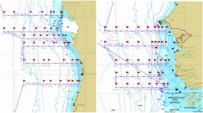
Abb. 4 Das Arbeitsgebiet der Reise M129 vor Mauretanien (links) und Senegal (rechts) Fig. 4 The working area of cruise M129 off Mauretania (left) and Senegal (right)
19
Arbeitsprogramm
Umfangreiche Stationsarbeiten sind geplant, um repräsentative Daten- und Proben für biogeochemische, mikrobiologische, Zoo- und Ichthyoplankton-Untersuchungen zu sammeln sowie Analysen zu Wassermassen, -strömungen, Benthos und Sedimentstruktur auf dem Schelf durchführen zu können.
Kohlen- und Nährstoffkreisläufe
CTD-Transekte vom flachen Schelf bis in den offenen Ozean werden sowohl vor Mau- retanien als auch Senegal durchgeführt. Der
„underway carbon dioxide analyzer“
SUNDANS wird zur kontinuierlichen Messung des pCO2 im Oberflächenwasser und der Atmosphäre eingesetzt. pH-Mes- sungen werden mit einer Ferrybox über eine pH-Elektrode und photometrisch mit einem SUNBURST AFT pH-Sensor durchgeführt.
Für kontinuierliche Messungen der Alka- linität kommt das VINDTA 2c zum Einsatz, DIC und TA werden aus diskreten Wasser- proben aus der Rosette mit VINDTA 3c ermittelt.
Mikrobiologie
Die Gemeinschaft der frei lebenden und an Partikel gebundenen Mikroben wird mit Hilfe von DNA Fingerprinting-Methoden sowie Tag-Sequenzierungen von ausgesuch- ten Proben untersucht werden. Der zweite Teil beinhaltet eine detaillierte Analyse der mikrobiellen Gemeinschaften verschiedener Wassermassen und Wassertiefen, die rele- vant für die Partikelbildung und den Parti- kelabbau sind. Inkubationsexperimente in Durchfluss-Rolltanks an Bord des Schiffes erlauben die Untersuchung der Rolle von Bakterien in der Partikelbildung und dem Abbau sowie den Wachstumsraten der Mik- roben unter quasi in situ Bedingungen.
Plankton
Für die Untersuchung der Kohlen- und Nährstoffflüsse vom Phytoplankton in höhe- re trophische Ebenen werden Wachstums- und Fressraten experimentell an Phytoplank- ton, Protisten und Copepoden bestimmt. Die
Work Programme
A comprehensive program has been de- signed to collect representative data and samples for biogeochemical and microbio- logical approaches, samples for ichtyo- plankton and zooplankton studies, water properties, and benthos and sediment on the shelf. We will routinely record the sea-floor morphology (parasound).
Carbon and nutrient cycles
CTD transects from the shallow shelf to the open ocean are required in the working are- as off Mauritania and Senegal. The „under- way carbon dioxide analyzer“ SUNDANS will be used to measure continuously the pCO2 in the surface water and the atmos- phere. The pH will be determined within a ferry box by a pH-electrode, and photomet- rically with a SUNBURST AFT pH sensor.
Furthermore, total alkalinity will be meas- ured continuously with VINDTA 2c , DIC and TA will be assessed through discrete samples from the Niskin bottles attached the CTD (VINDTA 3C) to allow us to compare pCO2 calculations and measurements.
Microbiology
The microbial community will be analysed by fingerprinting methods and additional tag-sequencing of selected samples of the free-living and the particle-attached frac- tion. The second part comprises a detailed analysis of microbial communities relevant in particle formation and degradation of particles collected from the different water masses and depth. Circumventing the bottle effect by using recently developed flow through rolling tanks, on-board incubation experiments with collected particles and natural microbial communities will allow the analyses of bacterial formation and deg- radation of particles and microbial growth rates.
Plankton
Examination of carbon and nutrient fluxes from phytoplankton to higher trophic levels will be done by growth and grazing rate experiments of phytoplankton, protists and 20
Experimente werden in 2,2 L Gefäßen durchgeführt, die an Deck über 24 h in ei- nem Durchflusssystem inkubiert werden.
Die durch unterschiedliche Produktivität und Artenzusammensetzung verursachte Varia- bilität wird durch Verwendung von Inkuba- tionswasser von küstennahen und –fernen Stationen abgeschätzt. Außerdem werden Proben fixiert, um Biomasse und Artenzu- sammensetzung von Protisten und Phyto- plankton zu bestimmen.
Ichthyoplankton
Um das Potential der fischereilichen Rekrutierung zu erfassen, konzentrieren sich die Arbeiten auf Abundanz, Verbreitung und Zusammensetzung der Ichthyoplankton- fauna. Vor Mauretanien sollen sechs küsten- senkrechte Schnitte mit jeweils 7-8 Sta- tionen bearbeitet werden. Verschiedene Netze sollen eingesetzt werden: Multinetze, Bongo, GULF, RMT und Neustonnetze.
Die Probennahmen auf der Banc d’Arguin und vor Sine Saloum werden in Kooperation mit der sedimentologischen Arbeitsgruppe durchgeführt.
Biosedimentology
Oberflächenproben von Sediment und Benthos werden auf die faunistische Artenzusammensetzung und Skelettstruktu- ren von Karbonat abscheidenden Organis- men hin untersucht. Geochemische Untersu- chungen der Skelette dienen als Indikatoren für Umgebungstemperatur, Nährstoffange- bot und pH. Sedimentproben werden mit Van Veen Greifer und Kastengreifer genom- men und an Bord gesiebt und vorbearbeitet.
Lebendflora und –fauna von der Sediment- oberfläche wird in Alkohol für spätere Ana- lysen konserviert.
copepods. The experiments will be conduct- ed in 2.2 L polycarbonate bottles, incubated for 24 h on deck in flow-through basins and conducted with water from both onshore and offshore stations to obtain an estimate of variability due to both differences in produc- tivity and in species composition. Simulta- neous with water sampling for experiments, samples will be taken and fixed to determine protist and phytoplankton biomass and spe- cies composition.
Ichthyoplankton
The fish studies focus on the abundance, distribution and composition of the ichthy- oplankton fauna in order to better under- stand the recruitment potential in the area.
Off Mauretania six transects perpendicular to the coast are planned with 7-8 stations each. Different nets will be used (multinet, Bongo, RMT and neuston nets).
The sampling in the Banc d’Arguin and Sine Saloum for the investigation of species com- position, growth and nutrition of commer- cially important species is planned in coop- eration with the sedimentoglogical work.
Biosedimentology
Surface samples of sediment and benthos will be taken in order to investigate the faunistic composition and the skeletal struc- ture of carbonate-secreting organisms (ef- fect of elevated CO2) as well as geochemical analyses of the skeletons as proxies for tem- perature, nutrient levels, and pH. The sedi- ment samples taken with a van veen grab and a giant box corer will be subsampled and sieved on board the vessel. Live fauna and flora from the sediment surface will be preserved in alcohol for further analysis.
21
Zeitplan / Schedule Fahrt / Cruise M129
Tage/days Auslaufen von Ponta Delgada (Portugal) am 27.07.2016
Departure from Ponta Delgada (Portugal) 27.07.2016
Transit zum Arbeitsgebiet / Transit to working area 3,5
Arbeiten vor Mauretanien 14
Station work in Mauretanian waters
Arbeiten vor Senegal 6,5
Station work in Senegalese waters
Transit zum Hafen Mindelo 2
Transit to port Mindelo
Total 26 Einlaufen in Mindelo (Kap Verdische Inseln) am 22.08.2016
Arrival in Mindelo (Cape Verde Islands) 22.08.2016
22
Bordwetterwarte / Ship's meteorological Station
Operationelles Programm
Die Bordwetterwarte ist mit einem Meteoro- logen und einem Wetterfunktechniker des Deutschen Wetterdienstes (DWD Hamburg) besetzt.
Aufgaben 1. Beratungen.
Meteorologische Beratung von Fahrt- und Schiffsleitung sowie der wissenschaftlichen Gruppen und Fahrtteilnehmer. Auf Anforde- rung auch Berichte für andere Fahrzeuge, insbesondere im Rahmen internationaler Zusammenarbeit.
2. Meteorologische Beobachtungen und Messungen.
Kontinuierliche Messung, Aufbereitung und Archivierung meteorologischer Daten und Bereitstellung für die Fahrtteilnehmer.
Aufnahme, Auswertung und Archivierung von meteorologischen Satellitenbildern.
Täglich sechs bis acht Wetterbeobachtungen zu den synoptischen Terminen und deren Weitergabe in das internationale Datennetz der Weltorganisation für Meteorologie (GTS, Global Telekommunication System).
Durchführung von Radiosondenaufstiegen zur Bestimmung der vertikalen Profile von Temperatur, Feuchte und Wind bis zu etwa 25 km Höhe. Im Rahmen des internationalen Programms ASAP (Automated Shipborne Aerological ) werden die ausgewerteten Da- ten über Satellit in das GTS eingesteuert.
Operational Program
The ships meteorological station is staffed by a meteorologist and a meteorological radio operator of the Deutscher Wetter- dienst (DWD Hamburg).
Duties:
1. Weather consultation.
Issuing daily weather forecasts for scientific and nautical management and for scientific groups. On request weather forecasts to other research craft, especially in the frame of international cooperation.
2. Meteorological observations and mea- surements.
Continuous measuring, processing, and ar- chiving of meteorological data to make them available to participants of the cruise. Re- cording, processing, and storing of pictures from meteorological satellites.
Six to eight synoptic weather observations daily. Feeding these into the GTS (Global Telecommunication System) of the WMO (World Meteorological Organization) via satellite.
Rawinsonde soundings of the atmosphere up to about 25 km height. The processed data are inserted into the GTS via satellite within the frame of the international programme ASAP (Automated Shipborne Aerological Programme).
23
Beteiligte Institutionen / Participating Institutions
DWD Deutscher Wetterdienst Seeschifffahrtsberatung Bernhard-Nocht-Straße 76 20359 Hamburg / Germany Internet: www.dwd.de FFCUL
Faculdade de Farmácia da Universidade de Lisboa Avenida Professor Gama Pinto
1649-003 Lisboa / Portugal Internet: www.ff.ul.pt GEOMAR
Helmholtz-Zentrum für Ozeanforschung Kiel Wischhofstr. 1-3
24148 Kiel / Germany Internet: www.geomar.de GeoZentrum Nordbayern Universität Erlangen-Nürnberg Schloßgarten 5
91054 Erlangen / Germany Internet: www.gzn.fau.de IFREMER
Centre Ifremer Bretagne.
Pointe du Diable
CS 10070. 29280 Plouzane / France Internet: wwz.ifremer.fr
IMROP
Institut Mauritanien de Recherches Océanographiques et des Pêches BP. 22, Nouadhibou / Mauritania
Internet: www.imrop.mr/
LMU Ludwig-Maximilians-Universität München Department für Geo- und Umweltwissenschaften Sektion Mineralogie, Petrologie und Geochemie Theresienstr. 41
80333 München / Germany
Internet: www.mineralogie.geowissenschaften.uni-muenchen.de
24
Memorial University
Memorial University of Newfoundland Department of Earth Sciences
Prince Philip Drive 300
St. John’s, NL A1B 3X5 / Canada Internet: www.mun.ca
NOC National Oceanography Centre
University of Southampton Waterfront Campus European Way
Southampton, SO14 3ZH / United Kingdom Internet: www.noc.ac.uk
SIOSOA
State Oceanic Administration – Second Institute of Oceanography No. 36 Baochubei Rd.
310012 Hang Zhou / China Internet: www.sio.org.cn
TI Thünen-Institute of Sea Fisheries Palmaille 9
D-22767 Hamburg / Germany Internet: www.ti.bund.de UCAD
Institut Fondamental d'Afrique Noire Université Cheikh Anta Diop B.P. 206, Dakar / Sénégal
Internet: www. ifan.ucad.sn/
University of Azores
Departmento de Oceanografia e Pescas Universidade dos Açores
Rua Prof. Dr. Frederico Machado 9901-862 Horta / Portugal
Internet: www.horta.uac.pt Universität Bremen
Fachbereich Geowissenschaften der Universität Bremen Klagenfurter Straße
28359 Bremen / Germany Internet: www.marum.de UHB University Bremen Postfach 33 04 40
28334 Bremen / Germany Internet: www.uni-bremen.de/
25
UHH University Hamburg
Institute of Geology / Institut für Geophysik Bundesstraße 55 (Geomatikum)
20146 Hamburg / Germany
Internet: www.geo.uni-hamburg.de University of Lisbon
LNEG – Laboratório Nacional de Energia e Geologia Estrada da Portea – Bairro do Zambujal
2721-866 Alfragide / Portugal Internet: www.lneg.pt
Universität Münster Institut für Mineralogie Corrensstraße 24
48149 Münster / Germany Internet: www.uni-muenster.de USBG University of Salzburg Dept. of Ecology and Evolution Hellbrunnerstr. 34
5020 Salzburg / Austria Internet: www.uni-salzburg.at
ZMT Leibniz-Zentrum für Marine Tropenökologie (ZMT) GmbH Fahrenheitstr. 6
28359 Bremen / Germany Internet: www.leibniz-zmt.de
26
Teilnehmerliste/ Participants Fahrt / Cruise M127
Name / Name Task Institut/Institute
1. Dr. Sven Petersen Chiefscientist GEOMAR
2. Dr. Jörg Bialas Co-chief scientist,
DTMCS GEOMAR
3. Dr. Alba Gil OBS NOC
4. Iain Stobbs geology/GIS NOC
5. Dr. Anke Dannowski OBS GEOMAR
6. Dr. Nico Augustin AUV bathymetry GEOMAR
7. Dr. Isobel Yeo AUV bathymetry, sidescan GEOMAR
8. Dr. Florent Szitkar self-potential, magnetics GEOMAR 9. Dr. John Jamieson Mineral resources Memorial University 10. Prof. Fernando J.A.S.
Barriga Mineral resources,
GC sediments FFCUL Lisbon
11. Sofia Martins GC sediments FFCUL Lisbon
12. Jelena Milinovic GC sediments FFCUL Lisbon
13. Dr. Kai Zhang Mineral resources SIOSOA
14. Dr. Honglin Li Mineral resources SIOSOA
15. Adeline Dutrieux GC porewater chemistry NOC
16. Dr. Anna Lichtschlag GC porewater chemistry NOC
17. Marcel Rothenbeck AUV GEOMAR
18. Lars Triebe AUV GEOMAR
19. Emanuel Wenzlaff AUV GEOMAR
20. Henning Schröder DTMCS GEOMAR
21. Tammy Jacobsen-Bialas DTMCS GEOMAR
22. Torge Matthiessen Technician GEOMAR
23. Gero Wetzel Electronic engineer GEOMAR
24. Meike Klischies Structural geology GEOMAR
25. Sebastian Graber Structural geology GEOMAR
26. N.N. / French observer Geology IFREMER
27. Holger Jens Meteorology DWD
28. Andreas Raeke Meteorology DWD
29. Laura Raeke Meteorology DWD
27
Teilnehmerliste/ Participants Fahrt / Cruise M128
Name / Name Task Institut/Institute
1. PD Dr. Christoph Beier Chiefscientist GeoZentrum Nordbayern 2. Prof. Dr. Karsten Haase Petrology, Geochemistry GeoZentrum Nordbayern 3. Dr. Felix Genske Petrology, Geochemistry Universität Münster 4. Dr. Stefan Krumm Petrology, Geochemistry GeoZentrum Nordbayern 5. Fabian Kemner, M.Sc. Petrology, Geochemistry GeoZentrum Nordbayern 6. René Romer, M.Sc. student Petrology, Geochemistry GeoZentrum Nordbayern 7. Bettina Storch, B.Sc. Petrology, Geochemistry GeoZentrum Nordbayern 8. Bernd Schleifer TV Grab Technician GeoZentrum Nordbayern 9. Prof. Dr. Wolfgang Bach Hydrothermal precipitates Universität Bremen 10. Dr. Andreas Klügel Hydrothermal precipitates Universität Bremen 11. Tom Skabraks Hydrothermal precipitates Universität Bremen 12. Íris Raquel Ferreira
Sampaio da Costa Biology Univ. of Azores, Horta
13. Maria Teresa Cerqueira Biology Univ. of Azores, Horta 14. Dr. Pedro Ferreira Petrology, Geochemistry Univ. of Lisbon, Lisboa
15. Dr. Ulrich Küppers Volcanology LMU
16. Marie Blum Seismics UHH
17. Franziska Petry Seismics UHH
18. Dr. Volker Ratmeyer ROV personell Universität Bremen 19. Prof. Dr. Gerold Wefer ROV personell Universität Bremen
20. Tom Leyman ROV personell Universität Bremen
21. Vincent Vittori ROV personell Universität Bremen
22. Anh Mai ROV personell Universität Bremen
23. Marcel Zarrouk ROV personell Universität Bremen
24. Tobias Schade ROV personell Universität Bremen
25. Arne Kausche ROV personell Universität Bremen
26. Harald Rentsch Meteorology DWD
27. Andreas Raeke Meteorology DWD
28
Teilnehmerliste/ Participants Fahrt / Cruise M129
Name / Name Task Institut/Institute
1. Dr. Werner Ekau Fahrtleiter / Chiefscientist ZMT
2. Prof. Dr. Hildegard Westphal Carbonate sediment ZMT
3. Peter Müller Carbonate sediment ZMT
4. Claire Reymond Carbonate sediment ZMT
5. Thilo Klenz CTD GEOMAR
6. Wiebke Martens CTD GEOMAR
7. Saliou Faye CTD UCAD-Dakar
8. Dr. Tim Rixen Biogeochemistry ZMT
9. Enno Bahlmann Biogeochemistry UHH
10. Jennifer Bachmann Microbiology ZMT
11. N.N. Microbiology ZMT
12. Prof. Stephen Wickham Microplankton USBG
13. Philipp Wenta Microplankton USBG
14. Maik Tiedemann Ichthyoplankton TI
15. N.N. Ichthyoplankton TI
16. Hans Sloterdijk Ichthyoplankton ZMT
17. N.N. Ichthyoplankton ZMT
18. Stephanie Bröhl Plankton ZMT
19. Bocar Balde Fisheries Biology IFAN
20. Marco Taviani Molluscs UHB
21. N.N. Plankton IFAN
22. N.N. Plankton IFAN/IMROP
23. Sebastian Flotow Boxcorer &Dust collection ZMT
24. N.N. Acoustics UHB
25. N.N. Acoustics UHB
26. Kees Camphuysen Macrofauna IMROP
27. Abdoul Dia Macrofauna IMROP
28. N.N. Beobachter/Observer Senegal
29. N.N. Beobachter/Observer Mauretania
30. Christian Rohleder Bordwetterwarte DWD
29
Besatzung / Crew Fahrt / Cruise M127
Dienstgrad / Rank Name, Vorname / Name, first name
Master Hammacher, Rainer
Chief Officer Volland, Helge
1st Officer Reinstädler, Marco
2nd Officer Apetz, Derk-Ude
Chief Engineer Hartig, Volker
2nd Engineer Heitzer, Ralf
2nd Engineer Brandt, Björn
Electrical Engineer Starke, Wolfgang Chief Electronics Voigt-Wentzel, Heinz
Electronics Schulz, Harry
System-Operator Bagyura, Bernhard
Motorman Schröder, Manfred
Motorman Kudraß, Klaus
Motorman Rademacher, Hermann
Fitter Lange, Gerhard
Bosun Hadamek, Peter
Ship's Mechanic Behlke, Hans Joachim
Ship's Mechanic de Moliner, Ralf
Ship's Mechanic Doliwa, Jannik
Ship's Mechanic Kruszona, Torsten
Ship's Mechanic Bußmann, Piotr-Marek
Ship's Mechanic Weiß, Eberhard
Ship's Mechanic NN
Chief Cook Wernitz, Peter
Cook's Ass. Fröhlich, Mike
Chief Steward Wege, Andreas
2nd Steward Parlow, Jan
2nd Steward Jürgens, Monika
Laundryman Chen, Xiyong
Trainee Mock, Benjamin
Trainee NN
Trainee NN
Trainee NN
Ship's Doctor Rathnow, Klaus-Peter
30
Besatzung / Crew Fahrt / Cruise M128
Dienstgrad / Rank Name, Vorname / Name, first name
Master Schneider, Michael
Chief Officer Volland, Helge
1st Officer Reinstädler, Marco
2nd Officer Apetz, Derk-Ude
Chief Engineer Hartig, Volker
2nd Engineer Heitzer, Ralf
2nd Engineer Brandt, Björn
Electrical Engineer Starke, Wolfgang
Chief Electronics Willms, Olaf
Electronics Schulz, Harry
System-Operator Seidel, Stefan
Motorman Krüger, Frank
Motorman Kudraß, Klaus
Motorman Rademacher, Hermann
Fitter Sebastian, Frank
Bosun Hadamek, Peter
Ship's Mechanic Hildebrandt, Hubert
Ship's Mechanic de Moliner, Ralf
Ship's Mechanic Doliwa, Jannik
Ship's Mechanic Kruszona, Torsten
Ship's Mechanic NN
Ship's Mechanic NN
Ship's Mechanic NN
Chief Cook Wernitz, Peter
Cook's Ass. Fröhlich, Mike
Chief Steward Wege, Andreas
2nd Steward Parlow, Jan
2nd Steward Zimmermann, Petra
Laundryman Chen, Xiyong
Trainee Mock, Benjamin
Trainee Erdmann, Ole
Trainee NN
Trainee NN
Ship's Doctor Hinz, Michael
31
Besatzung / Crew Fahrt / Cruise M129
Dienstgrad / Rank Name, Vorname / Name, first name
Master Schneider, Michael
Chief Officer Volland, Helge
1st Officer NN
2nd Officer Werner, Lena
Chief Engineer Hartig, Volker
2nd Engineer Heitzer, Ralf
2nd Engineer Neumann, Peter
Electrical Engineer Freitag, Rudolf
Chief Electronics Willms, Olaf
Electronics Schulz, Harry
System-Operator Seidel, Stefan
Motorman Krüger, Frank
Motorman Kudraß, Klaus
Motorman Rademacher, Hermann
Fitter Sebastian, Frank
Bosun Hadamek, Peter
Ship's Mechanic Hildebrandt, Hubert
Ship's Mechanic de Moliner, Ralf
Ship's Mechanic Doliwa, Jannik
Ship's Mechanic Zeigert, Michael
Ship's Mechanic NN
Ship's Mechanic NN
Ship's Mechanic NN
Chief Cook Götze, Rainer
Cook's Ass. Fröhlich, Mike
Chief Steward Wege, Andreas
2nd Steward Kaiser, Bettina
2nd Steward Zimmermann, Petra
Laundryman Chen, Xiyong
Trainee Schmid, Sebastian
Trainee Erdmann, Ole
Trainee NN
Trainee NN
Ship's Doctor Hinz, Michael
32
Das Forschungsschiff / Research Vessel METEOR
Das Forschungsschiff METEOR dient der weltweiten grundlagenbezogenen deutschen Hochsee-Forschung und der Zusammen- arbeit mit anderen Staaten auf diesem Ge- biet.
FS METEOR ist Eigentum der Bundes- republik Deutschland, vertreten durch den Bundesminister für Bildung und Forschung (BMBF), der auch den Bau des Schiffes finanziert hat.
Das Schiff wird als 'Hilfseinrichtung der Forschung' von der Deutschen Forschungs- gemeinschaft (DFG) betrieben. Dabei wird sie von einem Beirat unterstützt.
Das Schiff wird zu 70% von der DFG und zu 30% vom BMBF finanziert.
Der Senatskommission der DFG für Ozea- nographie obliegt die wissenschaftliche Be- gutachtung der Fahrtvorschläge, sie benennt die Fahrtleiter.
Die Leitstelle Deutsche Forschungsschiffe der Universität Hamburg ist für die wissen- schaftlich-technische, logistische und finan- zielle Vorbereitung, Abwicklung und Be- treuung des Schiffsbetriebes verantwortlich.
Sie arbeitet einerseits mit den Fahrtleitern partnerschaftlich zusammen, andererseits ist sie Partner der Briese Schiffahrts GmbH &
Co. KG.
The research vessel METEOR is used for German basic ocean research world-wide and for cooperation with other nations in this field.
The vessel is owned by the Federal Republic of Germany represented by the Ministry of Education and Research (BMBF), which also financed the construction of the vessel.
The vessel is operated as an 'Auxiliary Re- search Facility' by the German Research Foundation (DFG). The DFG is assisted by an Advisory Board.
The vessel is financed to 70% by the DFG and to 30% by the BMBF.
The Senate Commission for Oceanography of the DFG evaluates the scientific pro- posals and appoints the chief scientists.
The Operations Control Office for German Research Vessels at the University of Ham- burg is responsible for the scientific, tech- nical, logistical and financial preparation and administration of the research vessel as well as for supervising the operation of the vessel. On one hand, it cooperates with the chief scientists on a partner-like basis and on the other hand it is the direct partner of the managing owners Briese Schiffahrts GmbH & Co. KG.
33
5HVHDUFK9HVVHO
0(7(25
&UXLVHV1R0±0
±
0HWDOIOX[HVDQGUHVRXUFHSRWHQWLDODWWKHVORZVSUHDGLQJ7$*PLGRFHDQ ULGJHVHJPHQW10$5±%OXH0LQLQJ#6HD
7KHIRUPDWLRQDQGHYROXWLRQRIRFHDQLFSODWHDXVDFDVHVWXG\IURPWKH
$]RUHV3RUWXJDO±$]RUHV3ODWHDX
7KHUROHRIWKH%DQFG¶$UJXLQDQG6LQH6DORXPDVVLQNIRUPDWWHUIOX[HVDQG VRXUFHIRUSURGXFWLYLW\RIWKHVRXWKHUQ&DQDU\&XUUHQWV\VWHP±%$66
(GLWRU
,QVWLWXWIU0HHUHVNXQGH8QLYHUVLWlW+DPEXUJ /HLWVWHOOH'HXWVFKH)RUVFKXQJVVFKLIIH
KWWSZZZOGIXQLKDPEXUJGH
6SRQVRUHGE\
'HXWVFKH)RUVFKXQJVJHPHLQVFKDIW')*
%XQGHVPLQLVWHULXPIU%LOGXQJXQG)RUVFKXQJ%0%)
,661