A semantic e-Science infrastructure for an interdisciplinary research centre
Inaugural-Dissertation
zur
Erlangung des Doktorgrades
der Mathematisch-Naturwissenschaftlichen Fakultät
der Universität zu Köln
vorgelegt von
Christian Willmes
aus Köln
Köln 2016
Prof. Dr. Ulrich Lang
Tag der mündlichen Prüfung: 24. Mai 2016
Abstract 7
Zusammenfassung 9
Abbreviations & Acronyms 11
I Introduction 15
1 Aim, subject and outline of the thesis 17
1.1 Geography, the science of integration . . . 19
1.2 Collaborative Research Centre 806 . . . 20
1.3 Research objectives . . . 23
1.4 Outline of the thesis . . . 24
2 Related work and theoretical background 27 2.1 On data, information, and knowledge . . . 27
2.2 Data modeling, knowledge representation, and metadata . . . 33
2.3 On Networks, the Internet and interoperability . . . 50
2.4 Research Data Management . . . 56
2.5 e-Science . . . 66
2.6 Geographical Information Systems . . . 74
II Design, Methods and Technology 81 3 Demands and Design 83 3.1 Demands for e-Science infrastructure . . . 83
3.2 Research Data Management . . . 89
3.3 System architecture . . . 94
3.4 System integration and interoperability . . . 98
3.5 Copyright and licensing . . . .102
4 Development Methods 107 4.1 Web development . . . .107
4.2 System administration . . . .110
4.3 Top-down vs. bottom-up development approach . . . .111
4.4 Data model development . . . .113
4.5 Prototyping . . . .114
4.6 Linked Data . . . .116
5 Technology 119
5.1 Server infrastructure and technology . . . .119
5.2 Software infrastructure and technology . . . .122
III Implementation 137 6 CRC806-RDM Infrastructure 139 6.1 Data catalog . . . .142
6.2 Publications . . . .157
6.3 Members directory . . . .163
6.4 News & Blog . . . .165
6.5 Integrated Search . . . .166
6.6 Continuous integration and testing . . . .167
7 Spatial Data Infrastructure 169 7.1 GeoNode . . . .170
7.2 MapServer and MapProxy . . . .175
7.3 Typo3 Extension . . . .178
8 Knowledge base 181 8.1 Data model development . . . .181
8.2 Form based data entry . . . .188
8.3 Data import . . . .189
8.4 Data queries and display . . . .193
8.5 Data export . . . .196
IV Results 201 9 CRC806-RDM 203 9.1 Frontpage, news and blog . . . .204
9.2 Data catalog . . . .206
9.3 Publications DB . . . .211
9.4 Members directory . . . .214
9.5 Integrated search . . . .215
9.6 Data metrics and visitor statistics . . . .216
9.7 API endpoints . . . .219
9.8 Administration console . . . .220
10 CRC806-SDI 223 10.1 Maps . . . .223
10.2 OWS Interfaces . . . .228
10.3 Backend and data management . . . .231
11 CRC806-KB 233 11.1 Paleoenvironment GIS data collection . . . .233
11.2 Domain Knowledgebases . . . .238
11.3 Integration . . . .242
V Synthesis 245
12 Discussion 247
12.1 The CRC806-Database semantic e-Science infrastructure . . . .247
12.2 Discussion and evaluation of the demands . . . .253
12.3 Licensing and data policy . . . .259
12.4 CRC 806 Repository lifecycle . . . .260
12.5 Open Science . . . .262
12.6 Data metrics . . . .270
12.7 Cooperation with related Infrastructures . . . .272
13 Conclusion 275 13.1 Development and adaption of the CRC806-Database . . . .275
13.2 Data sharing and data reuse . . . .276
13.3 Open Science . . . .278
13.4 Semantic e-Science . . . .279
14 Outlook 281 14.1 Data preservation . . . .282
14.2 Post-Project phase and availability of the systems . . . .282
VI References 285
Bibliography 287
Tables 303
Figures 304
Listings 307
Danke 307
Erklärung 310
Well designed information infrastructure improves the conduct of research, and can connect re- searchers and projects across disciplines to facilitate collaboration. The topic of this thesis is the design and development of an information infrastructure for a large interdisciplinary research project, the DFG-funded Collaborative Research Centre 806 (CRC 806).
Under the name CRC806-Database the presented infrastructure was developed in the frame of the subproject "Z2: Data Management and Data Services", a so-called INF project, which is responsible for the research data management within a DFG funded CRC.
During the design, development and implementation of the CRC806-Database, the complex requirements for sound data management in the context of a large interdisciplinary research project were considered theoretically, as well as practically during the implementation. The pre- sented infrastructure design is mainly based on the requirements for research data management in CRC’s, that is mainly the secure storage of primary research data for at least ten years, as well as on the further recommendations, that are about support and improvement of research and facilitation of Web-based collaboration, for information infrastructure by the DFG.
The CRC806-Database semantic e-Science infrastructure consists of three main components, i.) the CRC806-RDM component that implements the research data management, including a data catalog and a publication database, ii.) the CRC806-SDI component that provides a Spa- tial Data Infrastructure (SDI) for Web-based management of spatial data, and additionally, iii.) the CRC806-KB component that implements a collaborative virtual research environment and knowledgebase.
From a technical perspective, the infrastructure is based on the application of existing Open Source Software (OSS) solutions, that were customized to adapt to the specific requirements were necessary. The main OSS products that were applied for the development of the CRC806- Database are; Typo3, CKAN, GeoNode and Semantic MediaWiki. As integrative technical and theoretical basis of the infrastructure, the concept of Semantic e-Science was implemented. The term e-Science refers to a scientific paradigm that describes computationally intensive science carried out in networked environments. The prefix "Semantic" extends this concept with the ap- plication of Semantic Web technologies. A further applied conceptual basis for the development of CRC806-Database, is known under the name "Open Science", that includes the concepts of
"Open Access", "Open Data" and "Open Methodology". These concepts have been implemented
for the CRC806-Database semantic e-Science infrastructure, as described in the course of this
thesis.
Die vorliegende Dissertation behandelt die Konzeption und Entwicklung einer Informationsin- frastruktur für ein großes interdisziplinäres Forschungsprojekt, den DFG geförderten Sonder- forschungsbereich 806 (SFB 806). Unter dem Namen CRC806-Database wurde die vorgestellte Infrastruktur im Rahmen des Teilprojekt "Z2: Data Management and Data Services", einem so genannten INF Projekt entwickelt, das für dass Forschungsdatenmanagement innerhalb eines SFB zuständig ist.
Während der Konzeption, Entwicklung und Umsetzung der Infrastruktur wurde auf die kom- plexen Anforderungen für das Datenmanagement im Rahmen eines interdisziplinären Forsch- ungsprojekt sowohl theoretisch, als dann auch mit der praktischen Umsetzung eingegangen.
Ziel der Arbeit ist die Beschreibung und Dokumentation aller Komponenten der Infrastruktur, inklusive ihrer Entwicklung und den dieser Entwicklung zugrunde liegenden Forschungen. Die Konzeption der Infrastruktur basiert auf den Anforderungen der DFG für das Forschungsdaten- management in SFB’s, sowie den erweiterten Empfehlungen zur Umsetzung der Forschungsin- frastruktur. Des Weiteren wurden die speziellen Anforderungen der im Projekt beteiligten wis- senschaftlichen Disziplinen, als auch auf den Wünschen der am SFB beteiligten Teilprojekte und Wissenschaftler berücksichtigt. Die CRC806-Database besteht aus drei Hauptkomponenten, i.) der CRC806-RDM Komponente, die das Forschungsdatenmanagement, inklusive Datenkatalog und Publikationsdatenbank implementiert, ii.) der CRC806-SDI Komponente, die eine Spatial Data Infrastructure (SDI) zur Web-basierten Verwaltung von Geodaten zur Verfügung stellt, und schließlich iii.) die CRC806-KB Komponente, die eine kollaborative virtuelle Forschungsumge- bung umsetzt. Aus technischer Perspektive, wurden für die Entwicklung der Anwendungen ex- istierende Open Source Software Lösungen den spezifischen Anforderung, z.B. durch die En- twicklung von eigenen Komponenten angepasst und eingesetzt. Die wichtigsten eingesetzten Open Source Software Produkte sind, Typo3, CKAN, GeoNode und Semantic Mediawiki.
Als integratives technisches und theoretisches Konzept der Infrastruktur wurde Semantic e- Science umgesetzt. Unter e-Science ("enhanced Science") versteht man ein Wissenschaftliches Paradigma, dass kollaborative Anwendungen auf der Basis von digitalen Infrastrukturen um- fasst. Durch den Präfix "Semantic" wird dieses Konzept um die Anwendung von Semantic Web Technologien zur Umsetzung der digitalen Infrastruktur erweitert. Eine weitere wichtige konzeptionelle Grundlage für die Entwicklung der CRC806-Database, sind die unter dem Namen
"Open Science" bekannten Konzepte zu "Open Access", "Open Data" und "Open Methodology".
Diese Konzepte wurden, soweit möglich umgesetzt und angewendet, wie im Verlauf dieser Arbeit
beschrieben.
AI Artificial Intelligence
ALM Application Lifecycle Management AFS Andrew File System
AMH Anatomically Modern Human AP Application Profile
API Application Programming Interface
BDD Behaviour Driven Development BSCW Basic Support for Cooperative
Work
CAA Computer Applications &
Quantitative Methods in Archaeology
CC Creative Commons
CERN Conseil Européen pour la Recherche Nucléaire CI CyberInfrastructure
CKAN Comprehensive Knowledge Archive Network
CLI Command Line Interpreter CMS Content Management System CNRI Corporation for National Research
Initiatives
CRC Collaborative Research Centre CSS Cascading Style Sheets
CSW Catalog Service for the Web CSV Character-Separated Values
DB Data Base
DBMS Data Base Managment System DCAT Data Catalog Vocabulary DCC Digital Curation Centre
DCMI Dublin Core Metadata Initiative DDD Domain Driven Design
DEM Digital Elevation Model DFG German Research Foundation DIN Deutsches Institut für Normung DL Digital Library
DMP Data Management Plan DNS Domain Name Service DOI Digital Object Identifier DRY Don’t repeat yourself
EU European Union
FOSS4G Free and Open Source Software for Geospatial
FTP File Transfer Protocol
GFZ Deutsches
GeoForschungsZentrum GI Geographic Infromation
GIS Geographical Information System GIScience Geographical Information Science GML Geography Markup Language GPS Global Positioning System GRDDL Gleaning Resource Descriptions
from Dialects of Languages HTML HyperText Markup Language HTTP Hyper Text Transfer Protocol IBM International Business Machines
Corporation
ICANN Internet Corporation for Assigned Names and Numbers
IETF Internet Engineering Task Force INSPIRE Infrastructure for Spatial
Information in the European Community
IoT Internet of Things
IP Internet Protocol
IRTG Integrated Research Training Group
IS Information System
ISBN International Standard Book Number
ISDM Information System Development Methodology
ISO International Standardisation Organization
ISSN International Standard Serial Number
IT Information Technology JRC Joint Research Centre JSON JavaScript Object Notation
KB Knowledge Base
KM Knowledge Management
KML Keyhole Markup Language KMS Knowledge Managment System KR Knowledge Representation LBS Location Based Services LAMP Linux, Apache, MySQL, PHP
server
LGM Last Glacial Maximum MDE Model-Driven Engineering MIS Marine Isotope Stage
MOOC Massive Open Online Course MVC Model View Controller
MW MediaWiki
NGO Non-Governmental Organization NISO National Information Standards
Organization
OA Open Access
OCLC Online Computer Library Center OGC Open Geospatial Consortium OKFN Open Knowledge Foundation OOP Object Oriented Programming OS Operating System
OSGeo Open Source Geospatial Foundation
OSI Open Source Initiative
OSM Open Street Map OSS Open Source Software OWL Ontology Web Language OWS OpenGIS Web Services PDF Portable Document Format PMIP Paleoclimate Modelling
Intercomparison Project PURL Persistent Uniform Resource
Locator
RAID Redundant Array of Independent Disks
REST REpresentational State Transfer RDBMS Relational database management
system
RDF Resource Description Framework RDFa RDF in Attributes
RDFS RDF Schema
RDL Research Data Lifecycle RDM Research Data Management RHEL RedHat Enterprise Linux RIF Rule Interchange Format RLC Repository Life Cycle RPC Remote Procedure Call
RRZK Regionales RechenZentrum Köln RSS Rich Site Summary
SAN Storage Area Network SDD Schema-Driven Development SDI Spatial Data Infrastructure
SF Semantic Forms
SFTP SSH File Transfer Protocol SKOS Simple Knowledge Organization
System
SLD Styled Layer Descriptor SMTP Simple Mail Transfer Protocol SMW Semantic MediaWiki
SOA Service Oriented Architecture SPARQL SPARQL Protocol And RDF Query
Language
SRF Semantic Result Formats
SSH Secure Shell
SWT Semantic Web Technology SQL Structured Query Language TER Typo3 Extension Repository TCP Transmission Control Protocol TMS Tiled Map Serice
UDP User Datagram Protocol UI User Interface
UKLAN Universität zu Köln LAN UN-GGIM United Nations Committee of
Experts on Global Geospatial Information Management UoC University of Cologne UoD Universe of Discourse URI Uniform Resource Identifier URL Uniform Resource Locator URM User Rights Management
VCS Version Control System VM Virtual Machine
VPN Virtual Private Network VRE Virtual Research Environment W3C World Wide Web Consortium WCS Web Coverage Service WebGIS Web-based GIS
WFP World Food Programme WFS Web Feature Service WHO World Health Organization WMS Web Map Service
WMTS Web Map Tile Service WWW World Wide Web
XML eXtensible Markup Language
YAML Yet Another Markup Language
Introduction
Semantic e-Science infrastructure for an interdisciplinary research project about Culture-Envi- ronment Interaction and Human Mobility in the Late Quaternary
1is the topic of this study. It includes the design, development, implementation as well as the management, organization, ad- ministration and maintenance of a considerably complex Information Technology (IT) infrastruc- ture. The here presented CRC806-Database is an innovative semantic e-Science infrastructure implementation. As described and discussed in detail in the following of this thesis, it offers a wide range of solutions for an even wider range of demands and requirements. These include technological, policy, and financial constraints and possibilities, as well as discipline specific considerations. The research approach, applied for this study, combines basic Computer Science and software development methodologies and technologies with concepts of Geoinformatics – including GIS and WebGIS –, GIScience and Geography – including models of space and time –, as well as basic concepts of the further Collaborative Research Centre (CRC) 806 participating disciplines of Archaeology, Geosciences (Geology, Meteorology) and Anthropology.
As the main theoretical background for the implementation of the CRC806-Database is the concept of Semantic e-Science (Hey et al. 2005; Fox et al. 2009; Ma et al. 2015). The term e-Science, first defined informally as "where IT meets scientists", was coined by Jim Gary, an US American computer scientist, in the late 1990’ies as Hey et al. (2009) described it in the book The Fourth Paradigm (Hey et al. 2009). In this book, which is a scholarly collection of chapters about the application of computational methods for data intensive science (i.e. e-Science), Hey et al. (2009) founded the basis for this new field of research, or maybe even a new research discipline.
The fourth paradigm is understood as the next or current scientific paradigm in the succession from the first paradigm, the empirical sciences, describing natural phenomena from observa- tions, which has been common to humans for at least the last thousand years. The second paradigm, that is understood as the theoretical branch of science in which models, mathematics, and formalizations revolutionized science, at least since Newton. The third paradigm is known as the computational branch that facilitates simulations of complex phenomena, which started dur- ing World War II. Now, in the early 21st century, we are at the beginning of the fourth paradigm, understood as data-intensive or data-exploring science. This work aims to facilitate technology for the application and conduct of the fourth paradigm within the CRC 806 project, and for the wider community.
The term semantic before e-Science in Semantic e-Science stems from the application of
1http://www.sfb806.de, accessed: 2016-03-26.
Semantic Web Technology (SWT) in the context of e-Science. Semantic e-Science concerns state- of-the-art technologies in knowledge representation, data interoperability, vocabulary and data services, and data processing (Fox et al. 2009; Ma et al. 2015). It is the next evolutionary step, to improve data interoperability and, thus, sharing and reuse of data. Like for the architecture of the World Wide Web (WWW), the link is the basic and most important concept of this work. Be it linking of Open Source Software technologies, or data, or infrastructures. This concept of the link will be one central theme of this study. This approach is also advocated by renowned institu- tions, for example by the United Nations Committee of Experts on Global Geospatial Information Management (UN-GGIM):
Most significant changes in the geospatial realm will come not through a single tech- nology, but rather from linking multiple technologies and policies (Norris 2015).
In this regard, the preferred application and implementation of networks instead of hierarchi- cal models, support the emergence of new or additional information and knowledge, from its intrinsic structure of linked annotations. This feature is the main argument for the application of SWT in context of the CRC806-Database.
The practical aim of this study is the creation of a Semantic e-Science infrastructure for the interdisciplinary research project CRC 806. That allows the management, including storage, organization and publication of research data, and to support and facilitate collaborative re- search within the project. This includes the design, architecture, implementation, and ongoing improvement of systems to support these goals, and also to communicate these with the scien- tific community and the interested public. The need for infrastructures like the here presented CRC806-Database for the management of data, to enable data reuse by the scientific community, for education, and for the wider public is increasingly acknowledged and appreciated nowadays.
Another important aim of this work is to contribute to implement the concepts of Open Science.
Open Science combines the concepts of Open Access and Open Data with approaches to Open Peer-review and Open Methodology with the application of Open Source Software . These con- cepts are applied and offered were possible throughout the CRC806-Database infrastructure. As further will be shown in the course of this study, there exists an enormous wealth of information in traditionally published research, in literature, in data collections published on the Internet, and in almost all domains of interest. The domains of concern to the CRC 806 are no exception to this. Consequently, the problem is not primarily the creation of new data; rather, it is to locate relevant existing data, integrate those with existing and new research questions and, thus, reuse the data for the creation of additional information, meaning, and — most important — knowl- edge. The work delivered for this thesis aims to contribute to a better solution for locating and reusing data to contribute to the solving of this matter.
However, a major problem for data sharing and publication is not of technical nature. Rather,
it is of cultural, or sociological or even of political nature. Because of these heterogeneous
obstacles and problems, it is still common behavior not to publish the primary data of research
analyses and its results (Nelson 2009). An additional main problem is the lack of incentive
for the publication of data. For many scientists, the publication of the raw research data has more disadvantages then advantages. Having the data in the public means that there are more possibilities to find errors in the applied methods and computations, thus exposing a potentially vulnerable surface that is simply prevented by not granting access to the data, where it is not asked for in the first place. By providing and advertising the benefits of the concepts, methods and technology known under the term Open Science, it is another major aim of this work to help improve the situation according to data sharing and data reuse.
It is commonly agreed that this problems need to be addressed and solved in the near future for the common good and to guarantee progress. Thus, the development of an Research Data Management (RDM) infrastructure implementing a list of basic functionality is demanded by the funding agency, the German Research Foundation (DFG), for Collaborative Research Centers like the CRC 806. The RDM infrastructure facilitates the storage, archiving, organization, and publication of research data created in the CRC 806, and implements these basic functionalities.
Additionally to the design and implementation of the RDM infrastructure, an Spatial Data Infras- tructure (SDI) for managing geospatial data, as well as a Knowledge Base (KB) system consisting of a collaborative Research Data Base supporting the collection, sharing, and analysis of the ac- tual research data of the project, was implemented. The integration of these three applications, including interfaces for the researchers to build data collections and to discover what data are available, is understood as the Semantic e-Science infrastructure.
1.1. Geography, the science of integration
As this thesis is apparently a thesis in Geography, but from the title and a superficial view on the contents, it seems more like a thesis in Information Science or even Computer Science, some considerations about why this thesis is a thesis in Geography are due.
You may ask, "How is Building e-Science infrastructure for an interdisciplinary research project
Geography?". Basically this work creates an IT infrastructure for the handling of data, informa-
tion, and knowledge about past environments and past human cultures and their migrations,
expansion, and dispersal over time. Creating a data model, and an according infrastructure, is
nothing else than describing some domain — in technical rigor, of course — and thus describ-
ing a subset of the earth. The earth is the subject of the discipline of Geography, as de Geer
(1923) defined the discipline more than 90 years ago: "the science and art of describing planet
earth ". Additionally, Geography is a most Newtonian discipline, rigidly framed in space and time
(Goodchild 2013: 1072). And this rigid Newtonian frame of space and time has a most important
role in the design, implementation and application of the here presented CRC806-Database in-
frastructure, as explained in detail in the following of this work. Furthermore, this research can
be considered part of Geographical Information Science (GIScience), and Geoinformatics, which
is how the discipline is usually called in Germany, because the handling of spatio-temporal geo-
graphic data and the application of Geographical Information System (GIS) concepts is of most
importance at the core of this study.
Geography also stakes a claim to the title of “integrating discipline” or an “integrated science,”
because of its concern with both social and environmental phenomena and processes (Goodchild 2013; Gebhardt et al. 2011). If one takes into account that the research of CRC 806! (CRC 806!) also has both aspects — the (paleo) environmental and the anthropological (social) phenomena, as well as processes of migration — the research in the project and thus the infrastructure to support this endeavor is of a geographic nature. Also, because the problem of integrating data from quite heterogeneous sources is a key topic of this thesis, the notion of Goodchild (2013: 1073) that "geography can be seen as the science of integration rather than integrating sciences", and the assertion that "[...] it seems clear that the most useful role that geography and GIScience can play is in exploring a science of integration,"(Goodchild 2013: 1076) supports the claim, that the research presented is geography.
Additionally, the research carried out in this dissertation is essentially about providing meth- ods and technology for describing planet earth better and thus contributes to the advances of geography and GIScience.
Integration requires the ability to represent the variation of context, in the form of structured geographic databases; to represent processes in the algorithms of soft- ware; to couple these representations using identical discretization of space and time;
and to analyze the impacts of uncertainties in the representations. None of these forms of generic expertise and knowledge are traditionally recognized as elements of either economics or ecology, but they are all fundamental to geography and GIScience (Goodchild 2013: 1073).
And finally, in times of the fourth paradigm all research disciplines are subject of a digital transformation in terms of how research is conducted. Finding out what kind of infrastructure and technology answers certain demands and questions of a given scientific discipline, is basic research for this discipline.
1.2. Collaborative Research Centre 806
The overall framework setting the constraints and the domain of this study is the CRC 806, a large DFG-funded, interdisciplinary and inter-institutional research project. From the universi- ties of Cologne, Bonn, and Aachen, about 80 researchers from the disciplines of Geosciences and Geography, Archaeology, and Anthropology are working together. DFG Collaborative Research Centers are funded in four-year phases, which are evaluated after the third year of each phase for a decision about further funding. A CRC can have up to three phases, which results in a maximum runtime of 12 years.
The CRC 806 is designed to capture the complex nature of chronology, regional structure, cli-
matic, environmental, and socio-cultural contexts of major intercontinental and transcontinental
events of dispersal of Anatomically Modern Human (AMH) from Africa to Western Eurasia, and
particularly to Europe (Richter et al. 2012a). Furthermore, the project concentrates on the time
span between the dispersal of AMH from Africa and the permanent establishment of man in Cen- tral Europe (Richter et al. 2012b; Schuck et al. 2009). This time span covers the last 190,000 years, including the last two glacials, from Marine Isotope Stage (MIS) 6 during the according inter-glacial period of MIS 5 to MIS 2 until the Holocene MIS 1 (Haidle et al. 2012; Schuck et al.
2009).
Geographically, the region of interest is North Africa and Western Eurasia (the Levante region and Europe), with a western corridor of dispersal along the southern Mediterranean coast over the Straight of Gibralta or the Lampedus route from today’s Tunisia to today’s Italy, and an eastern route along the Levant region into the Balkans or even east of the Black Sea through the Caucasus (see Fig. 1.1).
1.2.1. Research Scope of CRC 806
The research within the CRC 806 is mainly based on the "Out of Africa II" Theory (Mellars et al.
1989; Stringer et al. 1994; Richter 1996), which assumes that the Homo Sapiens Sapiens, also known as AMH, originated from East Africa around 190,000 years ago (Richter et al. 2012a) even though, it shall not be concealed, that this theory is highly debated within the paleoanthropolog- ical community (Richter 1996; Templeton 2002; Dennell et al. 2005; Richter et al. 2012b).
The CRC 806 focuses on three major research themes:
1. The climatic, environmental, and cultural context, 2. Secondary occurrences of expansion and retreat,
3. Population changes, mobility, and migration in coupled cultural and environmental systems.
The first theme tests the eastern and western corridors of dispersal from East Africa to Europe (see Fig. 1.1). The research and excavation sites along these corridors gather data to help the detection of climatic and environmental history in order to discover the impact on the dispersal of AMH to Europe.
The second theme looks into secondary occurrences of expansion and retreat of AMH, induced by environmental or cultural changes, which is about occupation, extinction, and re-occupation of focus areas by AMH over time.
The third theme concerns population changes, mobility and migration in cultural-environment systems. Particular interest is paid to the impact of human agency on the environment and internal mobility among sedentary prehistoric societies (Schuck et al. 2013: 13).
1.2.2. Structure of the CRC 806
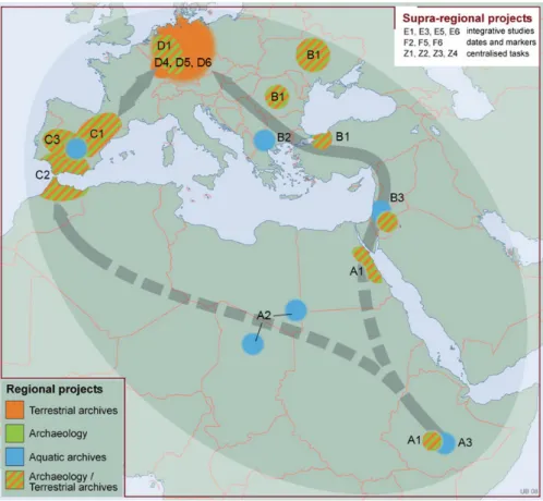
The CRC 806 consists of 21 research projects organized in seven research clusters in its second
funding phase (2013-2017). Those projects are led by 30 Principal Investigators from the Geo-
sciences and humanities at the Universities of Cologne, Bonn and the RWTH Aachen University
(Schuck et al. 2013: 11). The 21 research programmes are organized in four regional clusters
Figure 1.1.: Our Way. Source: (Richter et al. 2012a).
(A, B, C, D, see Fig. 1.2), two research clusters (E, F) dedicated to supra-regional questions and one cluster (Z) providing the centralized tasks and services of the CRC.
Project Z2: Data Management and Data Services
Within the context of the centralized tasks and services cluster Z, the Z2 project facilitates the research within the CRC 806 by providing data management infrastructure and services (Bareth et al. 2013). In the CRC 806 second-phase funding proposal project Z2 is introduced as follows:
The main purpose of an Information Infrastructure Project in a Collaborative Research Centre is the management of relevant data collected by the CRC with the aim of enabling systematic and long-term use of such data. Within the CRC 806, project Z2, headed by Georg Bareth and Olaf Bubenzer, is the main and centralized Information Infrastructure Project (Schuck et al. 2013: 24).
Thus the following aims of the project are identified:
1. Long-term archival of research data sets.
2. Collection of relevant data.
3. Enabling systematic use of data.
Figure 1.2.: Geographical focus regions of the second CRC 806 funding phase 2013 - 2017 (Schuck et al. 2013: 12).
4. Central information infrastructure of the CRC 806.
To implement these aims, the CRC806-Database
2was developed by project Z2, and further described in all detail in the following of this thesis. According to the DFG proposal guideline 60.06, it is expected that a CRC/TRR has a project section focusing on sustainable data storage and management (Bareth et al. 2013). Additionally, Z2 consults and provides GIS- and remote sensing analyses and the acquisition and preparation of different high- and low-resolution satel- lite data for the CRC 806 projects. Furthermore, using Terrestrial Laser Scanning (TLS), the creation of high-resolution point clouds and surface models for different aims could be carried out (Bareth et al. 2013).
1.3. Research objectives
To begin with a clear statement for the main objective, of improving the situation of data sharing and data reuse, a quote form the UN-GGIM report "Future trends in geospatial information management: the five to ten year vision" (Norris 2015) is cited here:
Our ability to create data is still, on the whole, ahead of our ability to solve complex
2http://crc806db.uni-koeln.de
problems by using the data. There remains no doubt that there is a huge amount of value still to be gained from the information contained within the data generated. The growth in the amount of data collected brings with it not only a growing requirement to be able to find the right information at the right time, but also challenges of how to store, maintain and use the data that is created (Norris 2015).
The quote shares the observation, that data is in general abundantly available, but access and reuse constraints for the data by the scientific community is part of the problem. And the last sentence, about "how to store, maintain and use the data" of the above quote is at the central concern of this work, applied for the demands and requirements of the CRC 806.
In this regard, the research objective is to deliver infrastructure and tools that help to support and facilitate the research of the CRC 806. This includes the four goals, as identified in the CRC 806 project proposal of Z2 (Bareth et al. 2013):
• Long-term archiving of research data,
• Collection of relevant data,
• Enabling systematic use of data, and
• Central information infrastructure of the CRC 806.
A further objective of this study is to improve the handling of spatio-temporal research data.
Thus, combining models and knowledge from the geography and Archaeology domians that are the core disciplines of the framing research project, are applied for designing and implementing the presented infrastrucutre. Consequently, it is also an important focus of this thesis to develop tools and data models, that improve the integration of data and research across the different disciplines involved in the CRC 806.
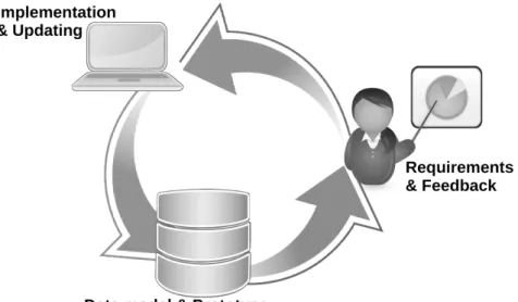
Another important research objective of this thesis is to contribute to the question of how innovative data management and e-Science infrastructure such as collaborative KB applications can be implemented to facilitate and improve the conduct of research in a large interdisciplinary research project.
1.4. Outline of the thesis
This thesis is structured in five parts and 14 chapters. The first part (Introduction) has two chap- ters, the first chapter, "Aim and subject of Study," explains the basic aims, objectives, and ideas of this thesis and introduces the overall academic and institutional and setting of the research project.
In the remainder of this thesis, the theoretical background and related work will be discussed
first in chapter 2 "Related work and theorethical backgropund." The related work covers a wide
ground: from the basics about data (2.1.1, p. 29), information (2.1.2, p. 29), and knowledge
(2.1.3, p. 31), to the essentials of data modelling (2.2, p. 33), metadata (2.2.1, p. 34), standards
(2.2.1), and interoperability (2.3). There follows an introduction to Semantic Web concepts and
SWT (2.2.4, p. 42), including the concept of Linked Data (2.2.4, p. 45). This leads to an overview of the basics of networks (2.3.1, p. 50) and the Internet (2.3.2, p. 54). Based on these grounds, the central concepts of RDM (2.4, p. 56) and e-Science (2.5, p. 66) are introduced. The related work is then concluded with an introduction to the concepts of web based spatial data handling and GIS in section 2.6.
Part II, "Design, Methods and Technology," is divided into three chapters. Chapter 3 "Demands and Design," gathers the demands that build the basis to implement the presented infrastrucu- ture. First, overall demands for e-Science Infrastrucutre are outlined (3.1), including funders demands (3.1.2), demands from the project partners (3.1.3), and basic requirements for building a KB (3.1.4). Then, the design of the applied RDM approach is given in section 3.2, followed by the technological overall system architecture of the CRC806-Database infrastructure in section 3.3. Section 3.4 provides a layout of how the subsystems of the presented infrastrucutre are integrated, and which technologies are provided to enable interoperability for access from third party infrastructures. This chapter is concluded with the copyright and licensing policy imple- mented in the presented system (3.5). Chapter 4, "Development Methods," explains the methods applied to implement the CRC806-Database infrastrucuture. Because the CRC806-Database is a web-based system, the first method explained is "Web development" (4.1). The second most important technology for building and maintaining a web based infrastructure is condensed in the term "System administration", as explained in section 4.2. The methods applied to develop the data models applied in the system are described in section 4.4, followed by an overview, in section 4.4.1, of the most important datasets used to build the basic data model and KB. In chapter 5, the technology stack applied for creating the infrastructure components is introduced.
The chapter is devided into a section about the physical server infrastructure (5.1) and a section about the software infrastructure (5.2).
Part III "Implementation," concernes the mainly technical implementation deatils. This part is strucutured in three chapters, each about one of the three main building blocks of the CRC806- Database. Chapter 6 describes the implementation of the CRC806-RDM infrastructure, contain- ing details about the data catalog (6.1), the publications database (6.2), the user management (6.3), the "News & Blogs" application (6.4), the integrated search and browse interface (6.5), and the Application Programming Interface (API) of the RDM infrastructure. In chapter 7, the implementation of the CRC806-SDI is explained. Section 7.1 describes the setup of the GeoN- ode backend. The setup of the additional SDI components of MapServer and MapProxy are described in section 7.2. The integration of the SDI compionents into the Typo3 based web ap- plication is described in section 7.3 . The implementation of the Semantic MediaWiki (SMW) based CRC806-KB is described in section 8. Section 8.1 describes how the data model and data schema are implemented in SMW, followed by the description of how the automated data import into the KB is facilitated (see section 8.3). The implementaion of web based User Interface (UI) to enter data manually is described in section 8.2.
Part IV "Results," presents the result of this thesis, that is the overall CRC806-Database se-
mantic e-Science infrastructure application. At first the result and features of the CRC806-RDM
infrastructure are presented in chapter 9. In chapter 10, the CRC806-SDI application is pre- sented, including its interfaces and features for geospatial data management. The resulting CRC806-KB system is presented in chapter 11.
Part V "Synthesis" is again structured in three chapters, "Disscussion of the Results" in chap-
ter 12, the "Conclusions" drawn from this work in chapter 13, and an outlook for the further
development and future of the CRC806-Database in chapter 14.
This chapter will give an introduction to the two basic concepts, of RDM, in particular to knowl- edge and data management and to the field of Semantic e-Science, fundamental to this work. To introduce these more general and complex topics, first the basics of data modelling, information technology and web technology, are introduced. Additionally, an overview of and introduction to GIS and SDI concepts are given because the capabilities in spatial data handling are a key feature of the presented infrastructure.
First, we take a look at how data, information and knowledge are defined and how they relate to each other in section 2.1. The emphasis of this section is on the investigation of the nature of data and aspects of emergence of information and knowledge from linking and contextualisation of data. This is followed by an introduction to data modeling, metadata, knowledge representation, and knowledge management in section 2.2. Because this thesis is about web-based infrastructure to facilitate research, basic concepts of networks, the Internet, the WWW and interoperability, including an introduction to semantic web technology, are given in section 2.3. After introducing these basic concepts, the field of RDM is detailed in section 2.4, followed by an introduction to e-Science and, in particular, Semantic e-Science and the consequences of the fourth paradigm, in section 2.5. The related work and theoretical background concludes with an overview of GIS and SDI technologies in section 2.6.
2.1. On data, information, and knowledge
Because this thesis is basically about handling data, information and knowledge, some thoughts about and definitions of these terms are given in this section. Data, information and knowledge are closely related terms, but each has its own role in relation to the other. This relation is formalized in a concept called the Knowledge Pyramid (Ackoff 1989) (see figure 2.1), to repre- sent the structural and functional relationship between data, information, and knowledge. Some models of the Knowledge Pyramid are extended to include the concept of wisdom above the con- cept of data, in this case it is called the DIKW Pyramid, for Data, Information, Knowledge, and Wisdom.
The inference from figure 2.1 is that data begets information begets knowledge begets wis-
dom. An additional inference is that there is more data than information, more information than
knowledge, and more knowledge than wisdom (Jennex 2009). A different formalization of that
same concept would be to express these relations in summations, of the form:
Figure 2.1.: The wisdom hierarchy (Rowley 2007), or the DIKW pyramid (Jennex 2009; Frické 2009) based on the Knowledge Pyramid (Ackoff 1989).
I = X (D)
K = X (I) = X X (D)
W = X (K) = X X (I) = X X X (D)
With: W =Wisdom, K =Knowledge, I =Information, D =Data.
One important purpose of the Knowledge Pyramid concept is to reflect that the level of abstrac- tion increases from data upwards to wisdom. Thus, the concept puts the relationship between data, information and knowledge into a hierarchical arrangement based on the level of abstrac- tion.
This concept has been part of the common canon for information science for many years, but it is not clear who came up with it first (Wallace 2007). However, the concept is not undisputed.
Jennex (2009) criticizes the concept as too basic and fails to represent reality and she presents
a revised knowledge pyramid in which knowledge management , as an extraction of reality with
a focus on organizational learning, is added to the concept. Frické (2009) has a strong critique
of the model and even demands that the Knowledge Pyramid should be abandoned in the canon
of Information Science because he doubts that it is "a useful and intellectually desirable concept
to introduce." In the next paragraph, however, he also admits that "disregarding DIKW would
leave an intellectual and theoretical vacuum over the nature of data, information, knowledge,
and wisdom" (Frické 2009: 132).
2.1.1. Data
The word "data" is the plural of "datum," the past participe of the Latin term "dare," which means "to give," hence datum means "something given" (Checkland et al. 1998: 86). Data can be described as the lowest level of abstraction or order (Elmasri et al. 2011: 2). A common general definition of data is:
"Basic, discrete, objective facts such as who, what, when, where, about something."
(Jennex 2009)
In a computer science and IT context, data is understood as machine readable and processable digital representations of infromation. Data is, in this context, always bound to a format specific to the kind of information or the software used to create or collect this data. The following, definition has more emphasis on this IT point of view:
"Data is factual information (as measurements or statistics) used as a basis for rea- soning, discussion, or calculation." (Longley et al. 2005).
With ease, the following definition by the ancient greek philosopher Plato emphasizes the purity of data:
"Data has no meaning or value because it is without context and interpretation." (Plato 400 BC), as cited in (Rowley 2007)
According to the many existing definitions of data, Rowley (2007: 171) interestingly asserts, that "[...] these definitions are largely in terms of what data lacks; data lacks meaning or value, is unorganized and unprocessed. They lay the foundations for defining information in terms of data."
To conclude, data are plain facts. When data are processed, organized, structured or presented in a given context so as to make them useful, they are called information. Data in themselves are fairly useless. However, when these data are interpreted and processed to determine their true meaning, they become useful and can be called information. Data is the computer’s language.
Information is our translation of this language.
2.1.2. Information
The word information is derived from Latin informare, which means "give form to" (Sveiby 1994).
In this sense, information can be understood as formatted data and as a representation of reality (Jessup et al. 2005: 7). The way the word information is used can refer to both "facts" in them- selves and the transmission of the facts (Sveiby 1994). The anthropologist and ecologist Gregory Bateson, defined the term infromation in a briliantly simple sentence as:
"Information is a difference that makes a difference." (Bateson 1987: 123)
According to that definition by Bateson (1987), the concept of data can be interpreted as the first difference in that definition of information. Emphasis here is on the difference in the semantic sense, by adding meaning to data, for example, through formatting, annotating, or contextualisation. This is also expressed in the following wider definition:
"Data that are related to each other through a context such that they provide a useful story, as an example, the linking of who, what, when, where data to describe a specific person at a specific time." (Jennex 2009)
In this definition, the term linking is used to define information. Semantically (meaningfully), purposeful and/or structured linking of data with other data creates information. Jashapara (2005: 16) formulates this same thought as follows: "Meaning in data often occurs through some form of association with experience or relationships with other data." Here, it is worthy to note that association and relationship are forms of linking.
A crucial point about the difference between information and data is that the human receiver determines whether a message or signal is data or information (Rowley 2007: 172). Here, infor- mation is defined in terms of data and is seen to be organized or structured data. The difference between data and information is elaborated in the following assertion:
"Information is differentiated from data by implying some degree of selection, orga- nization, and preparation for particular purposes – information is data serving some purpose or data that have been given some degree of interpretation." (Longley et al.
2005)
According to Bartelme (2005: 13), we speak of information as in the Geographic Infromation (GI) sense, if we receive an answer to a specific question, that increases our knowledge and helps to reach a goal behind the question. Bartelme (2005: 13) further emphasizes three important aspects of information:
• structural and syntactic (form) aspect,
• semantic (content) aspect,
• and the pragmatic (applied) aspect.
Bartelme (2005) illustrates these aspects in context of a letter. If you receive a letter in a foreign language that you are not educated in, you can understand the structure and syntax (address, sections, greetings, sentences, words, etc.), but you cannot understand the sense of the written text. On the other hand, if you receive a letter in English, where you can understand the content, but the content is irrelevant because it is an advertisement for example, it maybe qualifies as entertainment but not as information in the above-defined sense.
In the context of the knowledge pyramid, information is not regarded in the pure syntactic
sense of encoding but in the semantic sense of meaning and truth (Frické 2009: 139). It is
to note that this is dependent on the level of abstraction within the model of the knowledge
pyramid itself. Concepts of syntactic informations — such as, binary codes, Huffman trees, or Hamming codes known from computer science — also carry semantic information that is intrinsically linked to the definitions of these syntactic encodings and, through this linking to other data and information, in this sense the encoding definition, is also information in the sense discussed here.
2.1.3. Knowledge
Naturally, the definition of the concept of knowledge is much more complex than the definitions of data and information. It is also important to note, that we speak here of explicit knowledge (know what) that can be clearly formulated and recorded, and not of tacit knowledge (know how), that cannot be recorded since it is part of the human mind (Rowley 2007: 172). Knowledge is codifiable if it can be written down and transferred relatively easily to others. Tacit knowledge is often slow to acquire and much more difficult to transfer (Longley et al. 2005). The following definition gives an understanding of the complexity of the concept of knowledge:
"Knowledge is information that has been culturally understood such that it explains the how and the why about something or provides insight and understanding into something." (Jennex 2009)
Thus, knowledge is the understanding, awareness, or familiarity with some information, data, fact, or skill that is acquired through experience or education. Knowledge is also a network of information (Seemann 2014: 18); according to this idea, knowledge consists of information that is linked or related to other information. The information is thus embedded in a net of related and linked information or knowledge; this concept is also known as context and is included in the following definition:
"Knowledge is the ability to interpret data in context and thereby gain information."
(Dengel 2012: 5)
This definition also brings the human subject as an interpreter into the game. According to Bartelme (2005: 14), knowledge is the ability to use a number of single informations, to solve a given problem by a combination of these informations. He further emphasizes, that knowledge is also the ability to compare informations along defined criteria and to learn from them. This last aspects sounds very much like pure tacit knowledge, but it is the core area of interest for the Artificial Intelligence (AI) community, that works on building systems to deliver this kind of knowledge in a computerized manner. On the other hand, Boddy et al. (2005)[14] asserts that
"the amount of human contribution increases along the continuum from data to information to knowledge." This is also very well expressed in the following definition:
"Knowledge is the synthesis of multiple sources of information over time." (Rowley
2007: 173)
Concluding the pattern that linking entities of lower abstraction yield abstractions of higher order, as seen for linking data with data yields information, and linking information with infor- mation yields knowledge seems to make sense and points again to the importance of the concept of linking and networks for Information System (IS) and infrastructures.
Also, maybe even the concept of tacit knowledge could be described as an effect of emergence or synthesis, from connecting and relating informations and networks of information into new knowledge. But it is still noteworthy, that tacit knowledge is also highly subjective and depends on the personality, skills, technique, education, common sense, and experience of the individual.
2.1.4. Wisdom
To complete the introduction of the knowledge pyramid concept, we take a brief look at the concept of wisdom here. Data may present very little processing, in which, for example, obser- vations are directly recorded from a science experiment; information may involve an analysis of data; knowledge may represent an integration of different pieces of information and a conclu- sion; and wisdom may represent a reflection on this conclusion, in the light of other conclusions and experience (Hider 2012: 2).
"Wisdom is placing knowledge into a framework or nomological net that allows the knowledge to be applied to different and not necessarily intuitive situations." (Jennex 2009)
If knowledge has already a significant part of the interpreters role in its concept, then wisdom is an even more subjective concept. Jashapara (2005) states that "wisdom is a very elusive concept. It perhaps has more to do with human intuition, understanding, interpretation, and actions than with systems." Almost invariably, wisdom is highly individualized rather than being easy to create and share within a group. It is, in a sense, the top level of a hierarchy of decision- making infrastructure (Longley et al. 2005). Longley et al. (2005) further asserts that wisdom cannot be shared formally.
Because this thesis is manly about developing systems, we do not bother any further with the concept of wisdom in a technical sense here. The author leaves it to the reader to create wisdom from the concepts and systems described here.
In summary of this section on data, information and knowledge, data is the manifestation or
discretization (materialization) of measurements or observations. Data is created by assigning
observations to a system of assigning values according to the objects and concepts that are
central to the problem under study (Boslaugh et al. 2008). Thus, data depicts differences; data
is everything that can be expressed in ones and zeros (Seemann 2014: 18). According to this
insight, information consists of data. Now, where does this data make a difference according to
the definition of Bateson (1987)? It makes a differnce in the sense of the second difference in the
Bateson (1987) definition, in the concept known as knowledge. Data is information if it makes a
Table 2.1.: A ranking of the support infrastructure for decision making (Longley et al. 2005).
Decision making sup- port infrastructure
Ease of sharing with every- one
GIS example Wisdom
↑
Impossible Policies developed and accepted by stakeholders
Knowledge
↑
Difficult, especially tacit knowledge
Personal knowledge about places and issues
Evidence
↑
Often not easy Results of GIS analysis of several datasets and scenarios
Information
↑
Easy Contents of a database assembled
from raw facts
Data Easy Raw (geographic) facts