International Ocean Discovery Program Expedition 353 Preliminary Report
Indian Monsoon Rainfall
29 November 2014–29 January 2015
Steven C. Clemens, Wolfgang Kuhnt, Leah J. LeVay, and the Expedition 353 Scientists
April 2015
Publisher’s notes
Core samples and the wider set of data from the science program covered in this report are under moratorium and accessible only to Science Party members until 29 January 2016.
This publication was prepared by the International Ocean Discovery Program JOIDES Resolution Science Operator (IODP JRSO) as an account of work performed under the International Ocean Discovery Program. Funding for the program is provided by the following implementing organiza- tions and international partners:
National Science Foundation (NSF), United States
Ministry of Education, Culture, Sports, Science and Technology (MEXT), Japan European Consortium for Ocean Research Drilling (ECORD)
Ministry of Science and Technology (MOST), People’s Republic of China Korea Institute of Geoscience and Mineral Resources (KIGAM)
Australian-New Zealand IODP Consortium (ANZIC) Ministry of Earth Sciences (MoES), India
Coordination for Improvement of Higher Education Personnel, Brazil (CAPES)
Portions of this work may have been published in whole or in part in other International Ocean Discovery Program documents or publications.
Disclaimer
Any opinions, findings, and conclusions or recommendations expressed in this publication are those of the author(s) and do not necessarily reflect the views of the participating agencies, Texas A&M University, or Texas A&M Research Foundation.
Copyright
Except where otherwise noted, this work is licensed under a Creative Commons Attribution License. Unrestricted use, distribution, and reproduction is permitted, provided the original author and source are credited.
Citation
Clemens, S.C., Kuhnt, W., LeVay, L.J., and the Expedition 353 Scientists, 2015. Indian monsoon rainfall. International Ocean Discovery Program Preliminary Report, 353. http://dx.doi.org/10.14379/iodp.pr.353.2015
ISSN
World Wide Web: 2372-9562
Expedition 353 participants
Expedition 353 scientists
Steven C. Clemens Co-Chief Scientist
Department of Geological Sciences Brown University
324 Brooks Street Providence RI 02912-1846 USA
steven_clemens@brown.edu Wolfgang Kuhnt
Co-Chief Scientist
Institut für Geowissenschaften Christian-Albrechts-Universität zu Kiel Olshausenstrasse 40
24118 Kiel Germany
wk@gpi.uni-kiel.de Leah J. LeVay
Expedition Project Manager/Staff Scientist
International Ocean Discovery Program
1000 Discovery Drive College Station TX 77845 USA
levay@iodp.tamu.edu Pallavi Anand
Physical Properties Specialist Department of Earth Sciences The Open University Milton Keyes MK7 6AA United Kingdom
pallavi.anand@open.ac.uk Takuto Ando
Sedimentologist Hokkaido University
Department of Natural History Sciences
N10W8 Kita-ku Sapporo 060-0810 Japan
tact@mail.sci.hokudai.ac.jp Milos Bartol
Paleontologist (nannofossils) Institute of Earth Sciences Uppsala University Villavagen 16 752036 Uppsala Sweden
Milos.Bartol@geo.uu.se
Clara T. Bolton
Paleontologist (nannofossils)
Bioindicators and Paleoenvironmental Tracers Research Group
CEREGE, Europole de l’Arbois Europole Mediterranaen de l‘Arbois
Avenue BP 80 13545
Aix en Provence Cedex 4 France
bolton@cerege.fr Xuan Ding
Paleontologist (foraminifers) Department of Marine Science and
Engineering
China University of Geosciences 29 Xue Yuan Road
Haidian District Beijing
China
dingx@cugb.edu.cn Karen Gariboldi Paleontologist (diatoms)
Dipartimento di Scienze della Terra Università degli Studi di Pisa Via Santa Maria 53
56126 Pisa Italy
karen.gariboldi@for.unipi.it Liviu Giosan
Stratigraphic Correlator
Department of Geology and Geophysics Woods Hole Oceanographic Institution 266 Woods Hole Road, MS 22
Woods Hole MA 02543 USA
lgiosan@whoi.edu Edmund C. Hathorne Inorganic Geochemist
GEOMAR, Research Center for Marine Geosciences
Wischhofstrasse 1-3 24148 Kiel
Germany
ehathorne@geomar.de Yongsong Huang
Organic Geochemist
Department of Geological Sciences Brown University
324 Brook Street Providence RI 02806 USA
yongsong_huang@brown.edu
Priyank Jaiswal
Downhole Tools Specialist/Physical Properties Specialist
Boone Pickens School of Geology Oklahoma State University 105 Noble Research Center Stillwater OK 74075 USA
priyank.jaiswal@okstate.edu Sunghan Kim
Sedimentologist
Busan National University Department of Oceanography Busan 609-735
Republic of Korea delongksh@pusan.ac.kr John B. Kirkpatrick Inorganic Geochemist
Graduate School of Oceanography University of Rhode Island 215 South Ferry Road Narragansett RI 02882 USA
jbk@gso.uri.edu Kate Littler Sedimentologist
Camborne School of Mines University of Exeter Penryn Campus Cornwall TR10 9FE United Kingdom k.littler@exeter.ac.uk Gianluca Marino Stratigraphic Correlator
Research School of Earth Sciences The Australian National University Building 124 Mills Road
Canberra ACT 2601 Australia
gianluca.marino@anu.edu.au Philippe Martinez
Sedimentologist
University of Bordeaux UMR CNRS 5805 EPOC Allee Geoffroy de Saint Hilaire 33615 Pessac
France
philippe.martinez@u-bordeaux.fr
Dinesh Naik (boarded 30 December 2014)
Sedimentologist
Geological Oceanography Division National Institute of Oceanography Dona Paula
Goa 403 004 India
dnaik@nio.org
Aditya Peketi (boarded 30 December 2014)
Inorganic Geochemist
Geological Oceanography Division National Institute of Oceanography Dona Paula
Goa 403 004 India
aditya@nio.org Stephen C. Phillips Sedimentologist
Department of Earth Sciences University of New Hampshire 214 James Hall
56 College Road Durham NH 03824 USA
phillips.stephen.c@gmail.com Marci M. Robinson
Paleontologist (foraminifers) Eastern Earth Surface Processes United States Geological Survey 926A National Center
12201 Sunrise Valley Drive Reston VA 20192
USA
mmrobinson@usgs.gov Oscar E. Romero
Paleontologist (diatoms) MARUM
University of Bremen Leobenerstrasse 28359 Bremen Germany
oromero@uni-bremen.de
Netramani Sagar (boarded 30 December 2014)
Inorganic Geochemist Geochemistry Division National Geophysical Research
Institute (NGRI) Uppal Road Hyderabad Andhra Pradesh 500 007 India
n.sagar@ngri.res.in Katie B. Taladay
Downhole Tools Specialist/Physical Properties Specialist
Department of Geology and Geophysics SOEST
University of Hawaii at Manoa POST Building, Room 813 1680 East-West Road Honolulu HI 96822 USA
taladay@hawaii.edu Samuel N. Taylor Paleomagnetist
Laboratoire de Paleomagnetisme Institut de Physique du Globe de Paris 1 Rue Jussieu
75005 Paris France taylor@ipgp.fr Kaustubh Thirumalai Sedimentologist
Institute for Geophysics University of Texas at Austin J.J. Pickle Research Campus Building 196
10100 Burnet Road Austin TX 78758-4445 USA
kau@ig.utexas.edu
Goichiro Uramoto Sedimentologist
Kochi Institute for Core Sample Research
Japan Agency for Marine-Earth Science and Technology
B200 Monobe, Nankoku City Kochi 783-8502
Japan
uramotog@jamstec.go.jp Yoichi Usui
Paleomagnetist
Institute for Research on Earth Evolution
Japan Agency for Marine-Earth Science and Technology
2-15 Natsushima-cho Yokosuka 237-0061 Japan
yoichi@jamstec.go.jp Jiasheng Wang
Physical Properties Specialist Faculty of Earth Sciences China University of Geosciences Lumo Rodd 388
Wuhan Hubei Province China
js-wang@cug.edu.cn Masanobu Yamamoto Organic Geochemist
Hokkaido University
Faculty of Environmental Earth Science Kita-10, Nishi-5, Kita-ku
Sapporo 060-0810 Japan
myama@ees.hokudai.ac.jp Liping Zhou
Sedimentologist
Centre for Ocean Research Peking University
Yiheyuan Road Number 5 Beijing 100871
China
lpzhou@pku.edu.cn
Education and outreach
Juliet Crowell Education Officer
Smithsonian Science Education Center 901 D Street, SW, Suite 704-B
Washington DC 20024 USA
belize67@aol.com
Markus Fingerle Education Officer
Peutinger Gymnasium (High School) Peutinger Strasse 16
73479 Ellwangen/Jagst Germany
markus.fingerle@gmx.de
Siem Offshore AS officials
Terry Skinner
Master of the Drilling Vessel
Sam McLelland
Offshore Installation Manager
Technical support
Heather Barnes
Assistant Laboratory Officer Susan Boehm
X-Ray Laboratory Adam Bogus
Marine Laboratory Specialist (temporary) Chad Broyles
Curatorial Specialist Michael Cannon
Marine Computer Specialist Colin Carney
Marine Laboratory Specialist (temporary) Etienne Claassen
Marine Instrumentation Specialist William Crawford
Senior Imaging Specialist
Aaron de Loach
Marine Laboratory Specialist (temporary) Edwin Garrett
Petrophysics Laboratory Kevin Grigar
Operations Superintendent Margaret Hastedt Core Laboratory Jon Howell
Applications Developer Brad Julson
Laboratory Officer Jan Jurie Kotze
Marine Instrumentation Specialist Aaron Mechler
Marine Laboratory Specialist (temporary)
Erik Moortgat Chemistry Laboratory Algie Morgan Applications Developer Chieh Peng
Assistant Laboratory Officer Vincent Percuoco
Chemistry Laboratory Alyssa Stephens Publications Specialist Kerry Swain
Schlumberger Engineer Steven Thomas
Marine Computer Specialist Kevin Werts
Underway Geophysics Laboratory
Abstract
International Ocean Discovery Program (IODP) Expedition 353 (29 November 2014–29 January 2015) drilled six sites in the Bay of Bengal, recovering 4280 m of sediments during 32.9 days of on-site drilling. Recovery averaged 97%, including coring with the ad- vanced piston corer, half-length advanced piston corer, and ex- tended core barrel systems. The primary objective of Expedition 353 is to reconstruct changes in Indian monsoon circulation since the Miocene at tectonic to centennial timescales. Analysis of the sediment sections recovered will improve our understanding of how monsoonal climates respond to changes in forcing external to the Earth’s climate system (i.e., insolation) and changes in forcing inter- nal to the Earth’s climate system, including changes in continental ice volume, greenhouse gases, sea level, and the ocean-atmosphere exchange of energy and moisture. All of these mechanisms play crit- ical roles in current and future climate change in monsoonal re- gions.
The primary signal targeted is the exceptionally low salinity sur- face waters that result, in roughly equal measure, from both direct summer monsoon precipitation to the Bay of Bengal and runoff from the numerous large river basins that drain into the Bay of Ben- gal. Changes in rainfall and surface ocean salinity are captured and preserved in a number of chemical, physical, isotopic, and biological components of sediments deposited in the Bay of Bengal. Expedi- tion 353 sites are strategically located in key regions where these signals are the strongest and best preserved. Salinity changes at IODP Sites U1445 and U1446 (northeast Indian margin) result from direct precipitation as well as runoff from the Ganges-Brahmaputra river complex and the many river basins of peninsular India. Salinity changes at IODP Sites U1447 and U1448 (Andaman Sea) result from direct precipitation and runoff from the Irrawaddy and Sal- ween river basins. IODP Site U1443 (Ninetyeast Ridge) is an open- ocean site with a modern surface water salinity very near the global mean but is documented to have recorded changes in monsoonal circulation over orbital to tectonic timescales. This site serves as an anchor for establishing the extent to which the north to south (19°N to 5°N) salinity gradient changes over time.
Introduction
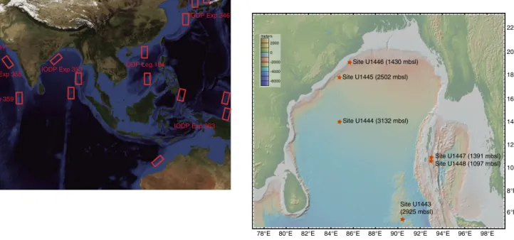
The R/V JOIDES Resolution has conducted scientific ocean drilling in many of the marginal basins surrounding monsoon-influ- enced regions of India and Asia including the Arabian Sea (Ocean Drilling Program [ODP] Leg 117), the South China Sea (ODP Leg 184), the East China Sea (Integrated Ocean Drilling Program Expe- dition 346), and the marginal sea bordered by the Eurasian conti- nent, the Korean Peninsula, and the Japanese Islands (Expedition 346). Sediments recovered have been used to reconstruct changes in summer monsoon upwelling and eolian transport (Leg 117), summer and winter monsoon surface and intermediate water dy- namics in the northern and southern regions of the South China Sea (Leg 184), the influence of the westerlies on monsoonal circulation in the marginal sea bordered by the Eurasian continent, the Korean Peninsula, and the Japanese Islands (Expedition 346), and the influ- ence of Yangtze River runoff on the surface waters of the East China Sea (Expedition 346). These records will be complemented by fu- ture drilling during scheduled International Ocean Discovery Pro- gram (IODP) expeditions in the Eastern Arabian Sea (Expedition 355), the Maldives (Expedition 359), and the Timor Sea (Expedition 363) (Figure F1). Prior to Expedition 353, however, no scientific
drilling has occurred in the core convective region of the Indo- Asian monsoon system, the northern Bay of Bengal. Scientific drill- ing last occurred in the Bay of Bengal in 1972 (Deep Sea Drilling Project Leg 22) when the D/V Glomar Challenger drilled Sites 217 and 218 in the southernmost Bay of Bengal (8°N to 9°N). However, scientific studies performed on India’s National Gas Hydrate Pro- gram Expedition 1 cores collected aboard the JOIDES Resolution in 2006 (Collett et al., 2008; Ramana et al., 2014), which provided the foundation for selecting most of the sites for Expedition 353, indi- cate the excellent potential for paleoclimatic and paleoceanographic reconstructions in the region (i.e., Ponton et al., 2012; Cawthern et al., 2014; Flores et al., 2014; Johnson et al., 2014; Phillips et al., 2014a, 2014b; Ali et al., in press). Expedition 353 fills this scien- tific/geographic gap by drilling targets in the Bay of Bengal that span 5°N to 20°N (Figure F2). Analysis of these sediments will help to address the scientific objectives outlined below.
Objectives
Pliocene–Pleistocene objectives
•Establish the sensitivity and timing of changes in monsoon cir- culation relative to insolation forcing, latent heat export from the Southern Hemisphere, global ice volume extent, and green- house gas concentrations;
•Determine the extent to which Indian and East Asian monsoon winds and precipitation are coupled and at what temporal and geographic scales;
•Better separate the effects of climate change and tectonics on erosion and runoff; and
•Provide verification targets for climate models, including the rapidly evolving water isotope–enabled, time-dependent mod- els.
Campanian–Miocene objectives
•Understand the timing and conditions under which monsoonal circulation initiated and reconstruct the variability of the Indian monsoon at orbital timescales;
•Understand the relationship between Indian monsoon variabil- ity and major past global climatic events such as the Oligo- cene/Miocene cooling (Zachos et al., 1997), the onset of the mid-Miocene climatic optimum (Holbourn et al., 2007, 2014;
Zachos et al., 2001), mid-Miocene cooling and Antarctic cryo- sphere expansion (Holbourn et al., 2013), and the Pliocene–
Pleistocene enhancement of Northern Hemisphere glaciation (Lisiecki and Raymo, 2005, 2007);
•Establish a complete Oligocene–present astronomically tuned timescale based on high-resolution benthic and planktonic iso- tope reference curves for the Indian Ocean; and
•Integrate high-resolution distribution studies of well-preserved Oligocene–recent calcareous and siliceous microfossils from the Indian Ocean into global compilation studies of paleoclimatic and biotic evolution.
Background
Motivation for drilling in the Bay of Bengal
Pliocene–Pleistocene
The three regions chosen for drilling during Expedition 353 (Mahanadi Basin, Andaman Islands, and northern Ninetyeast Ridge) delineate a north–south transect designed to capture past
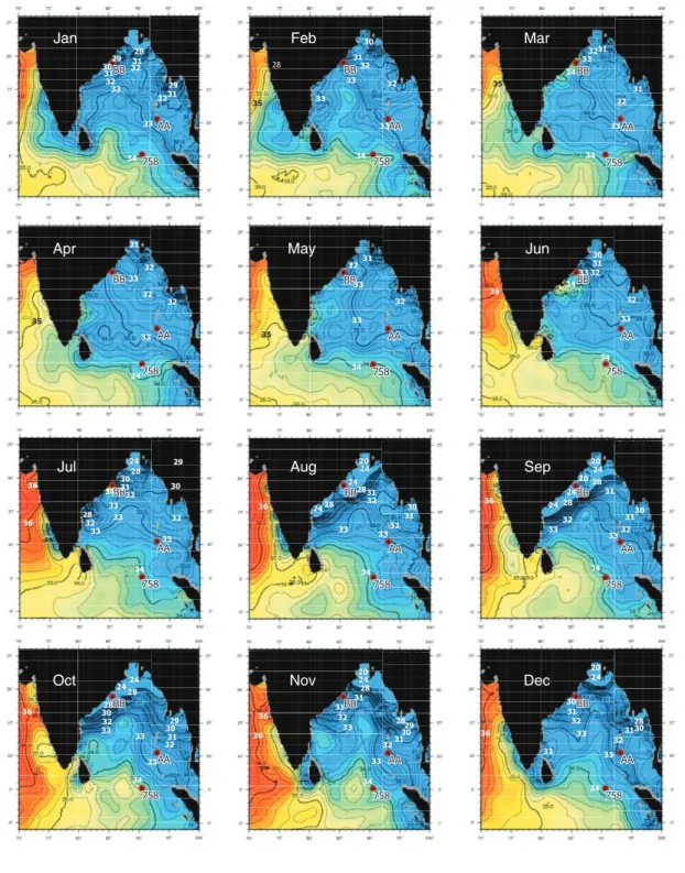
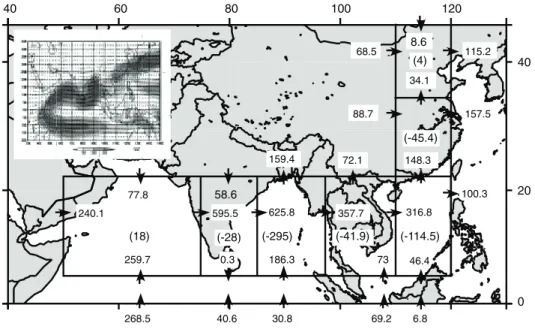
changes in the exceptionally strong salinity gradient observed in the modern Bay of Bengal (19°N to 5°N). A threefold motivation exists for targeting this precipitation/salinity signal. First, the Bay of Ben- gal/Andaman Sea and surrounding catchments are within the Earth’s strongest hydrological regime (Figure F3), impacting billions of people; a solid understanding of the physics behind monsoonal climate change is of significant societal relevance (Nicholls et al., 2007). The net annual surface water exchange (precipitation plus runoff minus evaporation) within the Bay of Bengal and Andaman Sea during the summer monsoon is 184 × 1010 m3, dominating the winter signal of −32 × 1010 m3 for an annual average of 152 × 1010 m3 (Varkey et al., 1996). The effects of this budget are clearly evident in the surface salinity climatology (Figure F4) (Antonov et al., 2010), indicating a well-defined, strong signal that can be used to monitor changes in monsoonal precipitation via chemical, physical, and iso- topic indicators for changes in precipitation, salinity, and terrestrial erosion/runoff. The extent of the low-salinity surface waters is suffi- cient to mute (via stratification) what would otherwise yield strong summer season productivity in response to wind-driven upwelling along the eastern Indian margin, similar to that seen in the Arabian Sea (Guptha et al., 1997; Kumar et al., 2002; Phillips et al., 2014b).
Hence, the Bay of Bengal is optimal for isolating and recording the summer monsoon precipitation signal in that the vast majority of precipitation, sourced from the Southern Hemisphere Indian Ocean, occurs during boreal summer (Figure F5).
Second, recent studies have called into question the extent to which basin-scale monsoon winds and continental precipitation are coupled over a range of timescales and space scales (Clemens et al., 2010; Clemens and Prell, 2007; Liu et al., 2006; Molnar, 2005; Ruddi- man, 2006; Wang et al., 2008; Ziegler et al., 2010). Nearly all proxy records indicate strong coupling between summer monsoon winds and precipitation across the Indo-Asian monsoon subsystems at the millennial scale (Altabet et al., 2002; Cai et al., 2006; Clemens, 2005;
Schulz et al., 1998; Sun et al., 2011; Wang et al., 2001); this tight cou- pling is likely attributed to the strong role of the winter westerlies in coupling high- and low-latitude climate change. However, the phys- ical mechanisms behind these links are not fully understood; this was a primary goal of recent Expedition 346. Progress is also being made in understanding winter monsoon and summer monsoon linkages at the millennial timescale. For example, recent work off- shore Goa, western India, shows synchronous breakdown in sum- mer and winter monsoon airflow over the Arabian Sea during Heinrich events (Singh et al., 2011), which is in contrast to the East Asian Monsoon system that shows an asynchronous relationship between summer and winter monsoon strength at the millennial scale (Yancheva et al., 2007).
Consensus does not yet exist on the extent of the coupling or the ultimate forcing of monsoon winds and precipitation at the orbital and longer timescales (An et al., 2011; Caley et al., 2011a, 2011b, 2011c; Cheng et al., 2009; Clemens and Prell, 2007; Clemens et al., 1996, 1991, 2008; Clift et al., 2008; Ruddiman, 2006; Wang et al., 2008; Ziegler et al., 2010). Some argue for a close coupling between changes in Indian and East Asian summer monsoon winds and pre- cipitation across the entire region spanning the Arabian Sea (Leg 117), the South China Sea (Leg 184), and terrestrial records from the Loess Plateau. In this case, changes in the strength of summer monsoon circulation across these regions are thought to be sensi- tive to Northern Hemisphere sensible heating (insolation), the tim- ing of energy release from the Southern Hemisphere Indian Ocean, and the timing of global ice volume minima (An et al., 2011; Caley et al., 2011b, 2011c; Clemens and Prell, 2003, 2007; Clemens et al.,
1996, 2008). In contrast, others interpret the timing of summer monsoon circulation, on the basis of speleothem records from southeast China, as forced directly by external insolation with little or no influence from internal boundary conditions such as ice vol- ume or Southern Hemisphere ocean–atmosphere latent heat ex- change (Cheng et al., 2009; Ruddiman, 2006; Wang et al., 2008).
Caballero-Gill et al. (2012) demonstrate that these contrasting in- terpretations are not attributable to differences in terrestrial and marine chronologies. Therefore, this lack of consensus points either to a strong deficit in our understanding of monsoon sensitivity to changes in the fundamental boundary conditions including insola- tion, ocean/atmosphere energy exchange, ice volume, and atmo- spheric greenhouse gas concentrations or to the confounding influence of seasonality on interpretation of proxy records (Figure F5).
Lack of consensus also extends to the tectonic scale, where the timing of monsoon intensification to modern strength is debated.
Some proxy records suggest initial intensification occurred at ~7–
8 Ma (e.g., Kroon et al., 1991; Prell et al., 1992), whereas others sug- gest a considerably earlier intensification, perhaps as early as early Miocene (~22 Ma) (Clift et al., 2008; Guo et al., 2002; Sun and Wang, 2005) or even late Eocene (~45 Ma) (Licht et al., 2014).
Emergence and expansion of arid-adapted C4 flora in South Asia argues for reduced precipitation since ~8 Ma (e.g., Cerling et al., 1997; Huang et al., 2007; Quade and Cerling, 1995), whereas proxies dedicated to reconstructing seasonality suggest, instead, little vari- ability in the monsoon over the last 10 My (Dettman et al., 2001).
Clift and Plumb (2008), Molnar et al. (2010), and the report from the Detailed Planning Group “Asian Monsoon and Cenozoic Tectonic History” (www.iodp.org/doc_download/2336-mmdp- greport) provide comprehensive overviews of these issues. More recently, Rodriguez et al. (2014) suggested that the ~8 Ma intensifi- cation inferred on the basis of increased Globigerina bulloides con- centrations is an artifact of increased preservation related to uplift of the Owen Ridge at this time, resulting in enhanced preservation.
Third, recent work suggests that interpretation of the oxygen minimum zone (OMZ) signal in the northern Arabian Sea (Leg 117) may be complicated by changing oxygen content of southern-source intermediate waters (Anand et al., 2008; Caley et al., 2011c; Schmit- tner et al., 2007; Ziegler et al., 2010). This presents a potential com- plication in the interpretation of the OMZ signal as a direct response to atmospheric circulation in the core region of summer monsoon winds (i.e., oxygen drawdown in response to decay of up- welling-produced organic carbon). Precipitation, salinity, and run- off indicators are not influenced by the chemistry of externally sourced intermediate and deep water masses, offering the potential to disentangle the influences of these factors in interpreting mon- soon proxy records.
The Expedition 353 drilling effort, targeting the core geographic region of summer monsoon precipitation, directly addressed these outstanding issues. Resolving these questions using the geological archive is important to providing verification targets for climate models, especially given that the majority of current Atmosphere- Ocean General Circulation Models (AOGCMs) used in the Inter- governmental Panel on Climate Change (IPCC) reports do not ac- curately simulate the spatial or intraseasonal variability of monsoon precipitation (Randall et al., 2007; Sharmila et al., 2015).
Deep time
Benthic foraminiferal diversity and assemblage composition, in conjunction with geochemical proxies of carbon flux, indicate a
stepwise increase in primary production and carbon flux and an ex- pansion of the intermediate water OMZ in the northeastern Indian Ocean since the late Oligocene (Gupta et al., 2013). The main in- creases in productivity started at 14 Ma (Gupta et al., 2013) or 10 Ma (Gupta et al., 2004) and reached levels associated with present Indian monsoon conditions around 2.3 Ma. This late Miocene to Pliocene “biogenic bloom” (Farrell et al., 1995) implies important changes in nutrient cycling in the Indian Ocean and probably on a global scale, which in particular affected the silica and phosphate cycles (Dickens and Owen, 1999). The productivity increase be- tween 10 and 8 Ma in the eastern equatorial Indian Ocean (onset of the biogenic bloom) may have been linked either to global cooling and the expansion of Antarctic ice sheets leading to a major change in deep ocean circulation and nutrient cycling, to the initiation of the Indian monsoons, or to a combination of both (Gupta et al., 2004).
Deep-sea benthic foraminiferal diversity in the Indian Ocean further decreased between 8 and 6 Ma and is associated with a neg- ative δ13C shift at 3.2–2.3 and 1.6–0.9 Ma, coinciding with an in- creased abundance of species indicative of increased organic carbon flux (Singh and Gupta, 2005). Since ~2.8 Ma, roughly coeval with the onset of Northern Hemisphere glaciation, benthic foraminiferal species that are well adapted to seasonally strong fluctuating carbon flux dominate the assemblages. This has been related to increased duration and strength of the northeast (winter) monsoon, which is accompanied by relatively low primary production in the eastern equatorial Indian Ocean (Gupta and Thomas, 2003). Expedition 353 will provide new Neogene intermediate water benthic foramin- iferal δ18O and δ13C records along a meridional transect to better understand the relative contribution of monsoon-induced changes in carbon flux and changes in intermediate water circulation linked to high-latitude climatic events such as fluctuations in the extension of the East Antarctic ice sheet. Analysis of Bay of Bengal surface sediments indicates that the foraminiferal lysocline, the depth de- limiting well preserved from noticeably dissolved assemblages, shoals significantly from south to north. The foraminiferal lysocline rises from 3800 to 3300 m between 0°N and 7°N (about Site U1443) then systematically shoals to ~2000 m at ~20°N (Indian margin sites) (Cullen and Prell, 1984), indicating enhanced carbon flux to the deep sea in the northern part of the Bay of Bengal.
The Expedition 353 meridional transect provides a unique op- portunity to investigate the nature and timing of variations in deep- water radiogenic isotope composition in response to restriction of the deepwater connection between the Pacific and Indian Oceans through the Indonesian Gateway since the mid-Miocene, to disen- tangle climatic variability from direct tectonic influences using non- Himalayan sedimentary sequences on the Indian continental mar- gin, and to evaluate the influence of enhanced Himalayan erosion since the late Oligocene at sites affected by a Himalayan signal in the Andaman Sea and Ninetyeast Ridge. The broad Oligocene passage between the Indian and Pacific Oceans must have enabled signifi- cant surface and intermediate water exchange and the possibility of deepwater flow from the Indian Ocean to the Pacific Ocean (Thomas et al., 2003). The progressive closure of the Indonesian Gateway caused by the northward movement of Australia (Hall, 2002; Hall et al., 2011; Kuhnt et al., 2004) induced changes in deep- water and intermediate water circulation through the Indonesian Gateway, which may have resulted in a significant change in the Eastern Indian Ocean Nd isotope composition during the middle Miocene (Frank et al., 2006; Gourlan et al., 2008). A second shift in Eastern Indian Ocean Nd isotopes may have been related to a shift
in the source area of the Indonesian Throughflow toward the North Pacific around 3.5 Ma (Cane and Molnar, 2001; Gourlan et al., 2008).
Geological setting
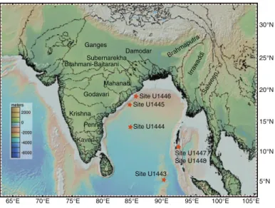
The eastern continental margin of India is the result of the sepa- ration of India and the Australia/Antarctica portion of Gondwana- land during the Early Cretaceous at ~130 Ma (Powell et al., 1988;
Scotese et al., 1988). The 2000 m isobaths of the northeast Indian continental margin and Lambert Graben of East Antarctica (Prydz Bay) are closely matched, supporting the inferred alignment of India and Antarctica prior to rifting (Subrahmanyam et al., 2008). The major Indian peninsular rivers draining into the Bay of Bengal (Fig- ure F6) are thought to be associated with graben features resulting from the rifting of India from Antarctica as well as subsequent In- dian plate motion. The Mahanadi Graben, for example, appears to have a continuation in Prydz Bay, Antarctica, known as Lambert Graben (Federov et al., 1982). Combined, the major river systems draining into the Bay of Bengal (Figure F6) discharge ~1630 km3/y (Achyuthan et al., 2013), accounting for ~50% of the total freshwater input, the remaining being from direct precipitation (Akhil et al., 2014).
Ninetyeast Ridge (NER) is an aseismic volcanic ridge spanning
~31°S to ~10°N, where it is buried beneath Bengal Fan sediments.
The NER is thought to have formed by age-progressive hotspot vol- canism from plume sources currently beneath the Kerguelen Pla- teau (Royer et al., 1991; Sager et al., 2010). The ridge top rises to a height of ~3.5 km above the surrounding abyssal plain with depths as shallow as ~2000 meters below sea level (mbsl). Site U1443 is lo- cated at ~5°N at 2925 mbsl. This location provides good preserva- tion of carbonate microfossils given that the foraminiferal lysocline in this region is close to 3300 m (Cullen and Prell, 1984).
The Andaman Sea is situated between the Andaman Islands and the Malaya Peninsula (Figure F2). The Andaman-Sumatra island arc system results from oblique subduction of the Indo-Australian plate beneath the Eurasian plate (Singh et al., 2013). Stretching and rifting of the overriding plate in the early Miocene (~25 Ma) has resulted in two distinct plates (Sunda and Burma) separated by an active spreading center (Curray, 1991) located in the deepest portion of the Andaman Sea. An accretionary wedge complex, which scraped off the subducting slab, lies west of the spreading center, forming a series of shallower basins associated with backthrust faulting within the accreted sediments (Figure F7). The Andaman Sea drilling sites are within the Nicobar-Andaman Basin, bounded on either side by the Diligent and Eastern margin faults. Terrigenous sediment sup- ply to the Andaman Sea originates dominantly from the Irrawaddy and Salween Rivers (Colin et al., 1998). Analysis of Andaman Sea surface sediments indicates that foraminifers are abundant and well preserved shallower than ~1800 mbsl (>100,000 individuals/gram) and decrease to <100 individuals/gram deeper than 3000 mbsl (Frerichs, 1971).
Modern atmospheric and oceanographic circulation
The Indian summer monsoon is characterized by low atmo- spheric pressure over the Indo-Asian continent (Indo-Asian Low) relative to high atmospheric pressure over the southern subtropical Indian Ocean (Mascarene High). The resulting pressure gradient leads to large-scale displacement of the Intertropical Convergence Zone and cross-equatorial flow of low-level winds carrying mois-
ture that is ultimately released over South Asia, the Bay of Bengal, and southeast China (Hastenrath and Greischar, 1993; Liu et al., 1994; Loschnigg and Webster, 2000; Webster, 1987a, 1987b, 1994;
Webster et al., 1998). Modern meteorological observations and moisture transport budgets (Figure F8) quantitatively show that the Southern Hemisphere Indian Ocean is the dominant source of moisture (latent heat) to the Indian and East Asian summer mon- soons during June, July, and August (JJA) (Bosilovich and Schubert, 2002; Ding and Chan, 2005; Ding et al., 2004; Emile-Geay et al., 2003; Liu and Tang, 2004, 2005; Park et al., 2007; Simmonds et al., 1999; Wajsowicz and Schopf, 2001; Xie and Arkin, 1997; Zhu and Newell, 1998). The Arabian Sea is a very minor moisture source (evaporation > precipitation), whereas the Bay of Bengal/Andaman Sea, India, the South China Sea, and southeast China are all mois- ture sinks (precipitation > evaporation) (Figure F8).
A total of 12 major rivers feed the Bay of Bengal/Andaman Sea (Ganges, Brahmaputra, Meghna, Damodar, Mahanadi, Godavari, Krishna, Irrawaddy, Salween, Penner, Kavery, and Mahaweli Rivers), discharging in total 943 × 109 m3 of water during the summer mon- soon months (JJA) (Varkey et al., 1996). Annual rainfall within and surrounding the Bay of Bengal is dominated by precipitation during JJA with the exception of the Madras Basin in southernmost penin- sular India, where rainfall peaks in November (Figure F9). The dominance of the JJA precipitation signal is reflected in the Bay of Bengal surface salinity patterns (Figure F4), spanning salinities of 20–34 over both seasonal (summer–winter) and spatial (north–
south) scales, with lowest values in August and September.
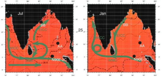
Primary surface ocean currents (Schott and McCreary, 2001;
Schott et al., 2009) reflect the seasonal wind forcing in both the eastern Arabian Sea and the Bay of Bengal (Figure F10). The West Indian Coastal Current (WICC) flows south during the summer monsoon, connecting with the Southwest Monsoon Current (SMC) that carries high-salinity waters eastward around the tip of India and Sri Lanka into the southern Bay of Bengal at a rate of 8.4 Sver- drup (Sv =106 m3/s). This influx of high-salinity water is reflected in the southern Bay of Bengal July, August, and September salinity pat- terns (Figure F4) and is successfully modeled as a passive tracer in mixed-layer ocean models (Jensen, 2001, 2003). Southwest summer monsoon winds in the Bay of Bengal also drive the northward-flow- ing East Indian Coastal Current (EICC). During the winter mon- soon, northeast winds drive all these surface currents in the opposite directions, transporting 11 Sv of water toward the eastern Arabian Sea.
Salinity on the Indian margin, northwest Bay of Bengal, reaches a minimum of ~22 in September (Figure F4); this is a lagged re- sponse to JJA rainfall over the Bay of Bengal and the surrounding drainage basins. Salinity at this location reaches a maximum of 34 during the spring months. The Andaman Sea sites, situated be- tween the modern 32 and 33 annual average isohalines, monitor drainage from the Irrawaddy and Salween Rivers. Salinity in the southern Bay of Bengal (Site U1443) is closely pinned to the 34 iso- haline year round, anchoring the southern end of the modern salin- ity gradient at near open-ocean values. Although this site does not currently experience significant seasonal salinity variability, it does record large-scale changes in precipitation and runoff at the millen- nial, orbital, glacial–interglacial, and tectonic scales as discussed be- low. The full meridional transect (spanning the Indian margin, Andaman Sea, and northern NER) has a modern salinity range of 12.
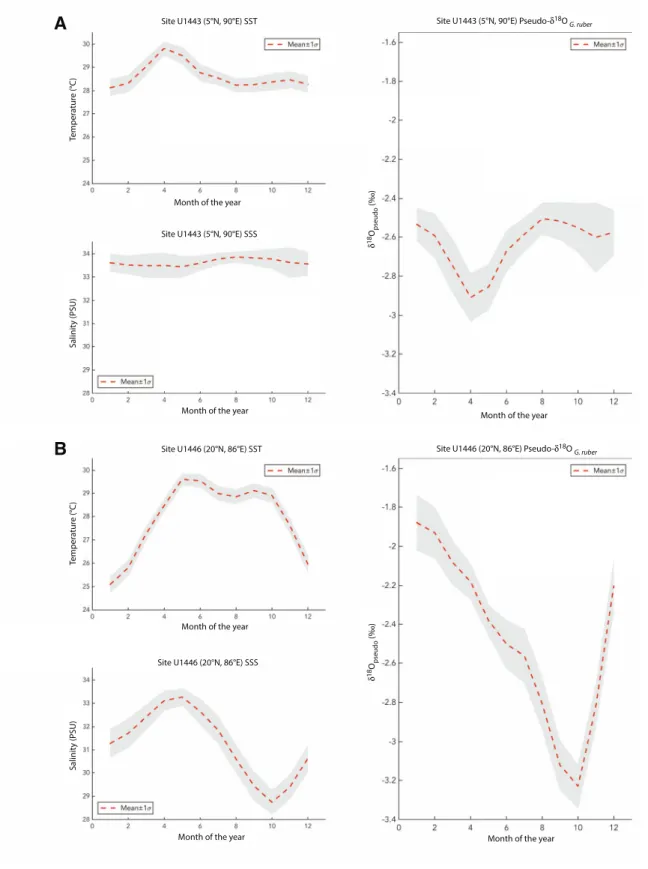
Estimates for expected δ18OG.ruber values can be calculated by combining climatologies for monthly temperature and salinity with
regional δ18Oseawater-salinity equations (Figure F11). Northern (20°N) values range between −1.9‰ for January and −3.3‰ for Oc- tober with strong sensitivity to the salinity seasonality. Estimates for 5°N range from −2.5‰ (August–December) to −2.9‰ (April) with strong sensitivity to the temperature seasonality.
Terrestrial runoff products are also of significant utility in as- sessing linkages between monsoon circulation, chemical weather- ing, and transport at timescales from millennial to tectonic (Clift and Plumb, 2008; Wang et al., 2005). Changes in monsoon strength are well documented at ~23, 15, 8–7, and 2.75 Ma (Clift and Plumb, 2008). The Expedition 353 targets will allow measurement of the consequent impact on weathering rates and transport of particulate materials to the ocean basins in a variety of settings both proximal and distal relative to river inputs.
Water masses and deep circulation
Comprehensive descriptions of eastern Indian Ocean regional oceanography are provided in Wyrtki (1971), Mantyla and Reid (1995), Tomczak and Godfrey (2003), and Schott et al. (2009), from which we briefly summarize descriptions of water masses and circu- lation patterns relevant for Bay of Bengal drilling in the depth range between 1100 and 3000 m targeted for Expedition 353.
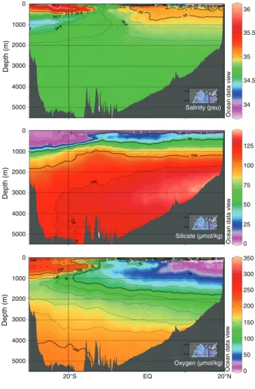
Indian Deep Water (IDW) occupies the depth range from 3800 to ~1500 m within the equatorial and northern Indian Ocean (Fig- ure F12). IDW in the eastern Indian Ocean is characterized by high salinities, reaching maxima of 34.8 in the southwestern Indian Ocean and 34.75 in the southeastern Indian Ocean, where the IDW upper limit rises to 500 m (Tomczak and Godfrey, 2003). IDW tem- perature, salinity, and oxygen properties in the high-salinity core are virtually identical with those of North Atlantic Deep Water (NADW) in the Atlantic sector of the Southern Ocean, indicating that IDW is mainly of NADW origin and not originally formed in the Southern Ocean, as is the Antarctic Bottom Water (AABW) that occupies the Indian Ocean deeper than 3800 m (Tomczak and Godfrey, 2003). The flow of IDW is northward and concentrated along the African margin and the NER as indicated by the World Ocean Circulation Experiment (WOCE) 95°E oxygen, silicate, and temperature profiles (Figure F13). IDW further penetrates north- ward into the Northern Hemisphere, is modified by mixing with thermocline water from above and upwelling of AABW from below, and spreads into the Arabian Sea and the Bay of Bengal.
Two water masses occupy the thermocline of the Indian Ocean, Indian Central Water (ICW) and Indonesian Throughflow Water (ITW) or Australasian Mediterranean Water (Figure F14). ICW originates from downwelling in the subtropical convergence south of 30°S, and ITW is derived from North Pacific Intermediate Water, strongly modified during its passage through the Indonesian archi- pelago. There is no formation of thermocline water in the Bay of Bengal, and its thermocline water masses to 1500 m water depth are derived from ICW and ITW. Transfer of ICW to the northern In- dian Ocean is accompanied by a rapid decrease in oxygen content, indicating aging along the path. The lowest oxygen values occur in the Bay of Bengal, which contains the oldest ICW. The strong oxy- gen decrease in the northern Indian Ocean can be explained by re- duction of the transfer of ICW during the southwest monsoon season, resulting in a small annual net transfer rate. ITW also con- tributes to the renewal of thermocline water in the northern Indian Ocean, resulting in significant freshening of the ICW along its path into the Bay of Bengal. Further freshening is observed in the Bay of Bengal near 90°E, resulting from ITW advection directly from its outflow area into the tropical eastern Indian Ocean. Variability and
evolution of thermocline circulation in the Bay of Bengal are strongly dependent on monsoonal forcing; however, the present ex- tremely low oxygen levels indicate a very low renewal rate for the thermocline waters of the Bay of Bengal.
The uppermost 100 m of the eastern Indian Ocean in the Bay of Bengal consists of a low-salinity water mass derived from river run- off from India and Indochina, the Bay of Bengal Water (BBW), with surface salinity strongly fluctuating with seasons but remaining be- low 33 throughout the year. The lower boundary to the ICW is characterized by a strong halocline. The southward extension of the BBW surface water mass is highest during October–December when it reaches the area along the western Indian coast and is low- est during April–June before the summer monsoon leads to a new expansion of the BBW.
Site summaries Site U1443
Background and objectives
The NER represents the trace of the Kerguelen/Ninetyeast hotspot prior to middle Eocene rifting (Peirce, Weissel, et al., 1989).
As a result of northward movement, Site U1443 moved from tem- perate southern latitudes during the Campanian to ~5°S near the Oligocene/Miocene boundary and to its present 5°N present loca- tion in the southernmost Bay of Bengal. The site has been within 10°
of the Equator for the past 35 My (Shipboard Scientific Party, 1989).
The ridge-top location (2935 mbsl) has prevented the deposition of sedimentary sequences typically associated with fan transport pro- cesses and is thus a useful location for recovery of open-ocean pe- lagic sediments.
Site U1443 is located ~100 m southeast of ODP Site 758 on the crest of the NER and is a redrill of Site 758 (Figure F2). Previous drilling at this site included overlapping holes (758A and 758B) only for the uppermost 92 m of the total 527 m of sediments drilled. This limited the resulting composite record to the past 7.3 My (Farrell and Janecek, 1991).
In spite of these limitations, the IODP sample database shows that more than 16,000 sediment samples have been taken from Site 758 cores in the last 10 y. Parts of the uppermost sections are almost entirely depleted, and sampling has moved to the archive half. Re- cent research using Site 758 sediments include high-resolution (suborbital) late Pleistocene reconstruction of changes in upper wa- ter column structure based on multispecies planktonic foraminifer records (Bolton et al., 2013), reconstruction of the Li isotope com- position of seawater over the past 70 My (Misra and Froelich, 2012), Late Cretaceous to early Eocene reconstruction of seawater neo- dymium (Le Houedec et al., 2012), and glacial–interglacial scale re- construction of Os isotopic composition of seawater (Burton et al., 2010). Drilling Site U1443 had the following main objectives:
•Establish a composite section for the entire Miocene–Oligocene sedimentary succession at the NER, which would be the base for establishing a first orbitally tuned Indian Ocean isotope strati- graphy for this time interval.
•Recover a more complete record of the Cretaceous/Paleogene boundary interval, which was only incompletely retrieved at the base of the core catcher of Core 121-758A-31X.
•Correlate the onset of increased terrigenous clay component and sedimentation rates in the late Miocene to orbitally tuned isotope and magnetic reversal stratigraphy.
•Precisely determine the timing of intensifications of the Indian monsoon, as evident from increased freshwater input to the Bay
of Bengal and northern end of the NER using salinity proxies based on Mg/Ca-temperature estimates and δ18O of surface- dwelling planktonic foraminifers.
• Investigate variability and possible influence of orbital forcing on fluxes of terrigenous material to the northern NER since the middle Miocene. In particular, relate terrigenous pulses at ~7.0–
5.6 and ~3.9–2.0 Ma, which were interpreted to represent varia- tions in the fluvial flux resulting from the uplift and erosion of the Himalaya (Hovan and Rea, 1992), to the variability of the In- dian monsoon.
• Extend the Pliocene–Pleistocene stable isotope record for Site 758, which is the only “high-resolution” record across the initia- tion of Northern Hemisphere glaciation in the Indian Ocean (Hoogakker et al., 2006; Mudelsee and Raymo, 2005), into the Miocene and Oligocene.
• Use the Nd isotope composition of NER sediments to extend re- constructions of the relative contribution of discharge from the Ganges-Brahmaputra, Irrawaddy, Arakan, and Indian peninsu- lar rivers as indicators of glacial–interglacial variability in mon- soon strength into the Miocene (Burton and Vance, 2000; Stoll et al., 2007; Gourlan et al., 2008, 2010). A complete Neogene sediment archive at Site U1443 opens the possibility to obtain- ing proxy records for river discharge in sufficient time resolu- tion to document the relation between global climate and the Indian monsoon throughout the Neogene.
Lithostratigraphy
Sediments recovered from Site U1443 reveal a range of pelagic and hemipelagic sediments of Late Pleistocene to Campanian age, comprising four distinct lithologic units (I–IV):
•Unit I (0–107.8 m core depth below seafloor [CSF-A]) is com- posed of Late Pleistocene–late Miocene light–dark gray nanno- fossil oozes with varying proportions of foraminifers, clay, and volcanic ash.
•Unit II (107.8–242.36 m CSF-A) is composed of pale yellow to white nannofossil oozes and chalks with varying amounts of au- thigenic carbonate and foraminifers that are late Miocene to early Oligocene in age.
•Unit III (242.36–308.68 m CSF-A) is late Paleocene to late Cam- panian in age and comprises a 66 m thick package of pale yellow and brown nannofossil chalks with varying proportions of authi- genic carbonate and occasional chert and porcellanite nodules and thin beds.
•In Unit IV, a total of 31 m (308.68–341.35 m CSF-A), compris- ing a succession of greenish gray marlstones with glauconite of late Campanian age, was recovered before Hole U1443A was terminated at 344 m drilling depth below seafloor (DSF).
Lithostratigraphic units are defined by changes in lithology (as identified by visual core description and smear slide observations), physical properties, and color reflectance (L*, a*, and b*). The ob- served lithologic differences between the units are primarily the re- sult of varying abundances of nannofossils, clay, and authigenic carbonate, with glauconite influencing the color and magnetic sus- ceptibility (MS) properties in Unit IV. Lithologic descriptions are based primarily on sediments recovered from Hole U1443A, sup- plemented with observations from Holes U1443B–U1443D.
Biostratigraphy
Calcareous nannofossils are abundant throughout the section in Hole U1443A, which is Late Pleistocene (<0.29 Ma) to Campanian (>72.1 Ma) in age, with a large unconformity that spans most of the
Eocene and the latest Paleocene. Nannofossil assemblages are typi- cally tropical to subtropical and are well preserved in the Pleisto- cene to the upper Miocene sections (~110 m CSF-A, lithologic Unit I). Below this interval, evidence of diagenetic overgrowth becomes apparent. Scanning electron microscope (SEM) analyses revealed that Emiliania huxleyi (<0.29 Ma) is present in intervals 353- U1443A-1H-1, 0–50 cm, and 353-U1443B-1H-1, 0–10 cm. Creta- ceous sediments contain abundant moderately to poorly preserved calcareous nannofossils. The Cretaceous/Paleogene (K/Pg) bound- ary was identified in Core 353-U1443A-39X but is highly biotur- bated and appears to be incomplete.
Planktonic foraminifers are dominant to abundant in Samples 353-U1443A-1H-CC through 43X-CC, which are Pleistocene to Late Cretaceous in age. Abundance decreases from common to few in Samples 44X-CC through 48X-CC. Preservation is good to mod- erate throughout the Cenozoic with a few exceptions in the late Miocene (Sample 13H-CC) and the Oligocene to Paleocene (Sam- ples 33X-CC and 34X-CC), where preservation is poor. Preserva- tion in the Cretaceous (Samples 39X-CC to 48X-CC) is moderate to poor.
At Site U1443, diatoms are most abundant from 0 to 28 m CSFA, whereas their occurrence becomes sporadic downsection until 192 m CSFA. The diatom community in the uppermost 28 m of Site U1443 is diverse and mainly consists of Pleistocene to Holocene species, mostly typical of warm to temperate low-latitude ocean wa- ters, and includes species indicating transport of coastal waters to Site U1443.
The age-depth relationship for Hole U1443A is based on the biostratigraphy of the three fossil groups studied (diatoms, plank- tonic foraminifers, and calcareous nannofossils) and paleomagnetic stratigraphy. Age datums of the fossil groups and paleomagnetism show good agreement for the Pleistocene. Calcareous nannofossils and planktonic foraminifers show consistent age-depth relation- ships throughout the Cenozoic and Late Cretaceous, with no major outliers. The combined biostratigraphic and paleomagnetic age model indicates a mean sedimentation rate of 1.20 cm/ky in the up- per part of lithologic Unit I (0–80 m CSF-A, Pleistocene to late Mio- cene). The mean sedimentation rate decreases to 0.41 cm/ky between 100 and 130 m CSF-A (the upper part of lithologic Subunit IIa, late Miocene to middle Miocene). Sedimentation rates between 135 and 200 m CSF-A (the lower half of lithologic Subunit IIa) aver- age 0.81 cm/ky (early Miocene to Oligocene). Finally, following a hi- atus that spans the late Oligocene to late Paleocene, the mean sedimentation rate in the late Paleocene and Late Cretaceous (litho- logic Units III and IV) is 0.36 cm/ky. These sedimentation rate and age estimates broadly agree with those published for Site 758.
Geochemistry
The composition of the interstitial water (IW) and bulk sedi- ment samples reflects the variation in sediment composition and reactions that occurred since deposition. Overall, the sediments have high carbonate content (>80 wt% throughout most of the sec- tion) and low total organic carbon (<0.3 wt%). IW major and minor element concentrations vary downhole. The depositional environ- ment changed as the site migrated from the Southern Hemisphere to the current location, as the collision of India with Asia delivered more and more terrigenous material to the location. In the upper sediments, ash deposition from the nearby Indonesian arc plays an important role. In general, the data from Site U1443 agree well with data from Site 758, but the new data provide a better resolution in the sections recovered by advanced piston corer (APC)/half-length
advanced piston corer (HLAPC) coring compared to the extended core barrel (XCB) coring at Site 758.
Paleomagnetism
Paleomagnetic measurements were conducted on all of the ar- chive half sections and 127 discrete samples taken from Holes U1443A–U1443C. Some of the discrete samples were also sub- jected to rock magnetic analyses. Magnetic polarity patterns were recovered for most of the APC and HLAPC cores but not for the XCB cores. The resulting magnetostratigraphy was produced for two time periods: 0–6 Ma (Holes U1443A and U1443C) and 18–25 Ma (Hole U1443A). The age-depth model from paleomagnetic measurements agrees well with the biostratigraphic ages. Between these age intervals, patterns based on pass-through magnetic mea- surements were inconclusive because of a decrease in natural rema- nent magnetization (NRM) intensity. A lithologic change to higher carbonate content and a decrease in the concentration of fine- grained ferrimagnetic minerals explains the poor signal. Prelimi- nary rock magnetic experiments suggest changes in bulk magnetic properties are primarily controlled by variations in the concentra- tion of fine-grained magnetite/maghemite.
Physical properties
Downhole variations in physical property measurements at Site U1443 reflect changes in lithology, condensed sections associated with depositional hiatuses, and diagenetic processes. The overall suite of physical property data is divided into three broad units with two subunits occurring within Unit II. These subunits mark import- ant anomalous events in the depositional history of this site. The general porosity trend decreases with depth with a few excursions correlating with the three subunits. In Unit I, high variability in MS, natural gamma radiation (NGR), P-wave velocity, and color reflec- tance reflect numerous ash layers intercalated within clayey nanno- fossil ooze. MS peaks are likely the result of higher iron content in the ash layers, and the color reflectance data display changes be- tween darker ash and lighter nannofossil ooze as well as changes in the clay content of the nannofossil ooze. Unit II is defined by a jump to an overall lighter color, with relatively uniform low NGR and low P-wave velocity trends. The sedimentologists identified this unit to be composed of chalk. From the physical property data, two anom- alous intervals were identified within Unit II. These intervals show a marked change to increased density, P-wave velocity, and NGR with no corresponding change in color reflectance. Thus, these changes in physical properties were undetectable by visual analysis of the core. The physical property anomalies were used to assist in direct- ing sampling for smear slide and SEM analysis, which together pro- vided evidence that the anomalous intervals reflected high authentic overgrowth and carbonate cementation correlating with strong, positive seismic reflections and biostratigraphically defined depositional hiatuses. Unit III data display an abrupt change to a darker color with higher NGR, MS, and P-wave values, suggesting a transition to a stronger, more lithified material with an increase in magnetic minerals and clays that are likely the result of an increase in terrigenous sediments. Overall, our physical properties results were generally found to be in good agreement with the lithostratig- raphy at this site.
Stratigraphic correlation
A composite section and splice to establish a continuous sedi- ment sequence was created using Holes U1443A–U1443D. Correla- tion and splicing was based on MS, NGR, and reflectance spectroscopy b* data. The MS data proved particularly useful for
correlation in the upper ~63 m core composite depth below seafloor (CCSF-A) because several tephra layers coincided with positive MS peaks. NGR and reflectance spectroscopy b* data were used throughout the rest of the records. A continuous splice was created spanning the upper 180 m, approximately tripling the length of time over which a continuous record was achieved for Site 758. This is mostly due to the use of the HLAPC, which greatly extended the length of piston-cored section.
Highlights
Pliocene–Pleistocene tephrochronology
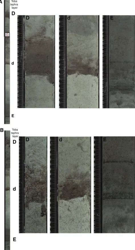
The Pliocene to Holocene tephra layers of the northern NER provide a unique record of explosive volcanism derived from the In- donesian island of Sumatra, the northernmost part of the Sunda arc, and the nearest volcanically active region (Dehn et al., 1991). Recov- ery of a complete succession of tephra layers within a complete splice with a high-resolution orbitally tuned isotope stratigraphy and the possibility of correlation of individual tephra layers between three holes make Site U1443 a unique observatory of volcanic activ- ity in this region over the last 5 My (Figure F15, F16, F17). The vol- canic tephra layers form excellent tools for lithostratigraphic correlation of the marine sediment successions within the five dif- ferent holes on the northern NER. Detailed studies of the tephra layers will contribute to the understanding of the magmatic evolu- tion in the source region and allow determination and precise dat- ing of eruptive cycles. In particular, the eruption history of the Toba Caldera in northern Sumatra is well documented on the northern NER (Ninkovich, 1979; Ninkovich et al., 1978; Dehn et al., 1991), and individual tephra layers at Site U1443 can be tentatively cor- related to the main eruptions of the Toba Caldera complex at 75,
~450, ~840, and ~1200 ka (Chesner and Rose, 1991; Dehn et al., 1991; Farrell and Janecek, 1991). The possibility of 40Ar/39Ar dating of these ash layers and correlation to a robust paleomagnetic rever- sal scheme at Site U1443 in combination with high-resolution stable isotope records will further contribute to intercalibrating Pliocene–
Pleistocene geomagnetic reversal and δ18O chronostratigraphy (Hall and Farrell, 1993, 1995).
Transitional Cretaceous/Paleogene boundary
The sedimentary record of the Cretaceous/Paleogene (K/Pg) boundary transition was difficult to assess at Site 758 because this interval was only recovered in Hole 758A. The transition occurs at the base of the core catcher of Core 121-758A-31X (295.6 meters below seafloor [mbsf ]) and is potentially incomplete because of the nearby coring gap between Cores 121-758A-31X and 32X. The Site U1443 K/Pg boundary (66.04 Ma) was identified between Samples 353-U1443A-39X-4W, 40 cm, and 39X-5W, 60 cm (Figure F18).
Sediments in this interval are heavily bioturbated (containing bur- rows, blebs, patches, color banding, and mottles), and most samples studied within this interval contain a mixture of Cretaceous and Pa- leocene nannoplankton species. In particular, Zoophycos spreite burrows are common in the K/Pg boundary succession and are a prominent feature in upper Maastrichtian sediments of Holes U1443A and U1443B. The interval below Section 353-U1443A- 39X-5W contains moderately to poorly preserved Cretaceous nan- nofossil assemblages. No latest Maastrichtian marker events were found, possibly a result of a minor hiatus.
First complete spliced record of Neogene deepwater sediments in the Indian Ocean
The continuous pelagic sediment record of Site U1443 with well-preserved benthic and planktonic foraminifers will allow ex- tension of existing Pliocene–Pleistocene isotope records from Site 758 to the base of the Neogene and tracking of deepwater and sur- face water isotopic signals in the eastern equatorial Indian Ocean over the last 25 My. Sedimentation rates >0.41 cm/ky will still allow analyses of stable isotopes and geochemical records in a resolution sufficient to resolve orbital-scale climate variability and to correlate these records to existing Atlantic and Pacific orbitally tuned isotope curves.
Late Oligocene to middle Miocene paleomagnetic record
The high-quality paleomagnetic record of Site 758 was limited to the uppermost 100 m, which was retrieved by APC coring. Below this level, biscuiting of the cored sediment by XCB coring prohib- ited high-quality magnetic measurements. At Site U1443, it was possible to use the APC and HLAPC core barrels to deeper than 200 m CSF-A, which opened up a new window for obtaining paleomag- netic records for the lower part of the Miocene and upper Oligo- cene. In particular, the record between 130 and 200 m CSF-A is characterized by high-quality paleomagnetic data that allow estab- lishment of a complete paleomagnetic reversal scale that covers the entire lower Miocene and upper Oligocene, including the Oligo- cene/Miocene stage boundary.
Recovery of expanded Campanian–Maastrichtian sediment succession
The Campanian to Maastrichtian part of the succession at Site U1443 is characterized by moderate to high recovery of indurated yellowish brown nannoplankton chalk, which grades downcore into greenish glauconite-rich chalk with intervals of abundant Inocera- mus shell fragments (Figure F19). The lower part of this interval in- cludes several centimeter-thick indurated chert nodules and nodular layers, which caused a significant decrease in drilling prog- ress and recovery in the lowermost two cores of Hole U1443A (Cores 353-U1443A-47X and 48X). The recovery of Upper Creta- ceous sediments above these Campanian siliceous layers was good in both Holes U1443A and U1443B, resulting in a complete strati- graphic record of this interval, which was characterized by only fragments recovered at Site 758. The low degree of diagenesis and the complete recovery may allow construction of a spliced bulk car- bonate carbon isotope record that covers the entire Maastrichtian to the middle/late Campanian including the Campanian/Maastrich- tian boundary.
A note on the Hole U1443A CSF-A depth scale
Stratigraphic and visual correlation indicates that ~5.4 m of sed- iment was lost from the bottom of Core 353-U1443A-1H (Figure F20). This is not surprising in light of the fact that four APC core barrels were bent or broke during attempts to establish the various holes at Site U1443. In this case, it is useful to know that one should add ~5.4 m to the CSF-A depth of all cores below Core 1H to make the CSF-A depths more consistent with those in Holes U1443B–
U1443D.
Site U1444
Background and objectives
The main scientific objective of Expedition 353 is to analyze the variability of the salinity gradient in the Bay of Bengal on suborbital to orbital timescales. To achieve this objective, site locations were selected according to the likelihood of continuous sedimentation and proximity to the main sources of freshwater feeding the North- ern Bay of Bengal, including the Mahanadi River and the Ganges- Brahmaputra river complex, and the Andaman Sea, including the Irrawaddy and Salween river systems.
Within one month prior to the start of the expedition, an alter- nate drilling plan was requested, one that included only sites in in- ternational waters. To accommodate this, we utilized existing site survey data acquired by the University of Bremen in 1997 and 2006 to locate drilling targets in the central Bengal Fan, following a latitu- dinal transect approach. This alternate plan included sets of sites at three different latitudes in international waters at 11°N, 14°N, and 17°/18°N.
Sediments at these alternative sites do not meet the paleocli- matic time-series oriented scientific objectives of Expedition 353 because the sedimentary archive of the Bengal Fan includes abun- dant coarse-grained turbidite sequences that do not have the strati- graphic integrity required for high-resolution reconstruction of climate change. However, the alternate sites on the Bengal Fan are complementary to the objectives of IODP Expedition 354 (France- Lanord et al., 2014). One of the crucial issues for Expedition 354 is the continuity of the terrigenous flux from the Himalayan source to the ~8°N drilling targets. Channel migration may, at times, decou- ple the middle fan from the supply. The addition of sites north of the 8°N Expedition 354 transect sites may help to evaluate these pro- cesses and provide additional material for the understanding of ter- rigenous flux into the Bengal Fan, one of the main objectives of the Expedition 354 drilling proposal.
Site U1444 (14°N, 84°49.74′E; 3143 mbsl) is located at common midpoint (CMP) 1302 on seismic Line GeoB97-041 (Schwenk and Spieß, 2009) (Figure F21A). The site is located in the western part of the lower Bengal Fan, close to the westernmost abandoned channel that fed the western part of the lower fan (Emmel and Curray, 1984).
Seismics (Figure F21B–F21C) suggest that these sediments are composed of a series of buried channel-levee sequences incised into hemipelagic sediments atop the underlying 85°E ridge. Schwenk and Spieß (2009) identified two prominent unconformities (Uc and Ud) bounding a more transparent hemipelagic unit between 4.32 and 4.20 s two-way traveltime (TWT), corresponding to ~105 to 185 mbsf. These unconformities can be traced for several hundred kilometers to the east along Line GeoB97-041 (Schwenk and Spieß, 2009). Similar regional-scale unconformities in the lower fan have been correlated to Site 218 and dated as earliest Pliocene (~4.8 Ma) and middle Pleistocene (~0.65 Ma) in age (von der Borch, Sclater, et al., 1974; Schwenk and Spieß, 2009). Unconformities Uc and Ud were inferred to be Pleistocene and Pliocene in age as well, but prior to drilling Site U1444, they had not been dated. A primary objective of this site was to determine the lithologic changes associated with seismic Reflectors (Unconformities) Uc and Ud and to date these reflectors in an effort to assess the degree to which turbidite and in- tercalated hemipelagic sequences are continuous from the upper to lower fan regions.
Coring summary
At Site U1444, Holes U1444A and U1444B were drilled to total depths of 330.6 and 128.6 m DSF, respectively. In Holes U1444A and
U1444B, the full-length (9.7 m long) APC system and the XCB sys- tem were primarily used. The HLAPC (4.7 m long) was used only for Core 353-U1444A-24F. For Holes U1444A and U1444B, the APC system was used to refusal followed by the XCB. A total of 46 cores were recovered at Site U1444. The APC cored interval was 160.0 m with a recovery of 156.21 m (98% recovery). The HLAPC cored interval was 4.8 m with a recovery of 3.94 m of core (82%).
The XCB cored interval was 246.9 m with a recovery of 140.06 m of core (57%). Hole U1444B contained a drilled interval from 47.5 to 95.0 m DSF. The overall recovery for Site U1444 was 73%.
Lithostratigraphy
Sediments recovered from Holes U1444A and U1444B can be divided into four lithostratigraphic units based on visual descrip- tion, smear slide analysis, and physical property measurements. The recovered lithologies are siliciclastic and are composed of turbidites with intercalated hemipelagic intervals.
•Unit I (0–95.01 m CSF-A) is composed of silty sand and silty clay with numerous turbidites.
•Unit II (95.01–168.91 m CSF-A) is primarily nannofossil-rich clay with silt and foraminifers. Turbidites in Unit II are less abundant, thinner, and finer than in Unit I.
• Unit III (176.1–255.6 m CSF-A) is characterized by very poor re- covery and is dominated by silty fine to medium sand.
• Unit IV (255.6–323.3 m CSF-A) is composed primarily of nan- nofossil-rich clay and clayey silt interbedded with sand and silt turbidites.
Turbidites at this site show typical erosional bases and normal (fining-upward) grading but rarely show structures typical of classic Bouma or Stow sequences (e.g., parallel, wavy, or lenticular lami- nae). Structureless turbidites suggest very rapid sedimentation and/or disturbance of the water-saturated sands during drilling and recovery. Turbidites were classified visually by their maximum grain size as either silt or sand. At Site U1444, turbidites can be classified compositionally from visual and smear slide descriptions as mica rich, well sorted quartz dominant, organic debris rich, or glauconite rich. The overall lithologic differences between units and variation in turbidite grain size and thickness are consistent with fluctuations in the proximity of active turbidity current channels on the Bengal Fan.
Biostratigraphy
The biostratigraphic age model for Site U1444 was established by combining nannofossil and planktonic foraminifer datums from Hole U1444A. Age-depth relationships for the two fossil groups show good agreement. All samples were nearly or completely bar- ren of diatoms. Calcareous microfossils (nannofossils, planktonic foraminifers, and benthic foraminifers) at Site U1444 were rare or absent in turbidite-rich sequences and common to abundant in hemipelagic sediment sequences. Where calcareous microfossils were present, preservation was good to moderate and rarely poor.
Foraminifers ranged in preservation from poor to good in the sam- ples in which they occur.
Nannofossil assemblages were of Pleistocene to late Miocene age and tropical/subtropical in character. Most Pleistocene, Plio- cene, and late Miocene calcareous nannofossil bioevents used to de- fine the biostratigraphic zones were present. This enabled us to assign all samples from hemipelagic sediment sequences and many samples from turbidite-rich sequences to a single biozone. Emil- iania huxleyi is present in Sample 353-U1444A-9H-CC near the