DISS. ETH NO. 27042
C OLLABORATIVE V ISUAL -I NERTIAL
S TATE AND S CENE E STIMATION
A thesis submitted to attain the degree of DOCTOR OF SCIENCES of ETH ZURICH
(Dr. sc. ETH Zurich)
presented by
M
ARCOK
ARRER MSc ETH in Mechanical Engineeringborn on October 18, 1988 citizen of Röschenz BL, Switzerland
accepted on the recommendation of Prof. Dr. Margarita Chli, Examiner Prof. Dr. Giorgio Grisetti, Co-examiner
Prof. Dr. Marc Pollefeys, Co-examiner
2020
Department of Mechanical and Process Engineering ETH Zurich
Switzerland
c
2020 Marco Karrer. All rights reserved.
Abstract
The capability of a robot to create a map of its workspace on the fly, while constantly updating it and continuously estimating its motion in it, constitutes one of the central research problems in mobile robotics and is referred to as Simultaneous Localization And Mapping (SLAM) in the literature. Relying solely on the sensor-suite onboard the robot,SLAMis a core building block in enabling the navigational autonomy necessary to facilitate the general use of mobile robots and has been the subject of booming research interest spanning over three decades. With the largest body of related literature addressing the challenge of single-agentSLAM, it is only very recently, with the relative maturity of this field that approaches tackling collaborativeSLAM with multiple agents have started appearing. The potential of collaborative multi-agentSLAM is great; not only promising to boost the efficiency of robotic missions by splitting the task at hand to more agents but also to improve the overall robustness and accuracy by boosting the amount of data that each agent’s estimation process has access to.
WhileSLAMcan be performed using a variety of different sensors, this thesis is focused on the fusion of visual and inertial cues, as one of the most common combinations of sensing modalities in robotics today. The information richness captured by cameras, along with the high-frequency and metric information provided by Inertial Measurement Units (IMUs) in com- bination with the low weight and power consumption offered by a visual-inertial sensor suite render this setup ideal for a wide variety of applications and robotic platforms, in particular to resource-constrained platforms such as Unmanned Aerial Vehicles (UAVs). The majority of the state-of-the-art visual-inertial estimators are designed as odometry algorithms, providing only estimates consistent within a limited time-horizon. This lack in global consistency of estimates, however, poses a major hurdle in an effective fusion of data from multiple agents and the practi- cal definition of a common reference frame, which is imperative before collaborative effort can be coordinated. In this spirit, this thesis investigates the potential of global optimization, based on a central access point (server) as a first approach, demonstrating global consistency using only monocular-inertial data. Fusing data from multiple agents, not only consistency can be maintained, but also the accuracy is shown to improve at times, revealing the great potential of collaborativeSLAM. Aiming at improving the computational efficiency, in a second approach a more efficient system architecture is employed, allowing a more suitable distribution of the computational load amongst the agents and the server. Furthermore, the architecture imple- ments a two-way communication enabling a tighter collaboration between the agents as they become capable of re-using information captured by other agents through communication with the server, enabling improvements of their onboard pose tracking online, during the mission.
In addition to general collaborativeSLAMwithout specific assumptions on the agents’ relative pose configuration, we investigate the potential of a configuration with two agents, carrying one camera each with overlapping fields of view, essentially forming a virtual stereo camera.
With the ability of each robotic agent to move independently, the potential to control the stereo
i
Abstract
baseline according to the scene depth is very promising, for example at high altitudes where all scene points are far away and, therefore, only provide weak constraints on the metric scale in a standard single-agent system. To this end, an approach to estimate the time-varying stereo transformation formed between two agents is proposed, by fusing the egomotion estimates of the individual agents along with the image measurements extracted from the view-overlap in a tightly coupled fashion. Taking this virtual stereo camera idea a step further, a novel collabo- ration framework is presented, utilizing the view-overlap along with relative distance measure- ments across the two agents (e.g. obtained via Ultra-Wide Band (UWB) modules), in order to successfully perform state estimation at high altitudes where state-of-the-art single-agent meth- ods fail. In the interest of low-latency pose estimation, each agent holds its own estimate of the map, while consistency between the agents is achieved using a novel consensus-based sliding window bundle adjustment. Despite that in this work, experiments are shown in a two-agent setup, the proposed distributed bundle adjustment scheme holds great potential for scaling up to larger problems with multiple agents, due to the asynchronicity of the proposed estimation process and the high level of parallelism it permits.
The majority of the developed approaches in this thesis rely on sparse feature maps in order to allow for efficient and timely pose estimation, however, this translates to reduced awareness of the spatial structure of a robot’s workspace, which can be insufficient for tasks requiring careful scene interaction and manipulation of objects. Equipping a typical visual-inertial sensor suite with an RGB-D camera, an add-on framework is presented that enables the efficient fusion of naturally noisy depth information into an accurate, local, dense map of the scene, providing sufficient information for an agent to plan contact with a surface.
With the focus on collaborativeSLAMusing visual-inertial data, the approaches and sys- tems presented in this thesis contribute towards achieving collaborative Visual-Inertial SLAM (VI-SLAM) deployable in challenging real-world scenarios, where the participating agents’ ex- periences get fused and processed at a central access point. On the other side, it is shown that taking advantage of specific configurations can push the collaboration amongst the agents to- wards achieving greater general robustness and accuracy of scene and egomotion estimates in scenarios, where state-of-the-art single-agent systems are otherwise unsuccessful, paving the way towards intelligent robot collaboration.
Zusammenfassung
Die Fähigkeit eines Roboters eine Umgebungskarte zu erstellen, diese kontinuierlich zu aktual- isieren und seine Eigenbewegung innerhalb dieser Karte abzuschätzen bildet eine der zentralen Forschungsfragen in der mobilen Robotik und wird als Simultaneous Localization And Map- ping (SLAM) bezeichnet. Da hierzu lediglich die im Roboter intergrierten Sensoren benötigt werden, stelltSLAMein Kernbaustein zur Ermöglichung autonomer Navigation, und somit dem praktischen Einsatz von mobilen Robotern, dar und ist eines der florierenden Forschungsinter- essen der letzten drei Dekaden. Während sich der Grossteil der Literatur mitSLAMfür einzelne Agenten befasst, wurde erst vor kurzem damit begonnen die Zusammenarbeit mehrerer Agen- ten fürSLAMzu untersuchen. Das Potential für kollaborativen Multi-AgentenSLAMist gross, einerseits ermöglicht das Aufteilen einer Aufgabe auf mehrere Agenten eine Mission effizien- ter zu erledigen, andererseits kann aufgrund der umfassenderen Datenmenge auf welche jeder Agent Zugang hat die Robustheit und Genauigkeit gefördert werden.
WährendSLAMprinizipiell mit einer Vielzahl von Sensoren möglich ist, lag der Fokus dieser Dissertation auf der Kombination von visuellen und inertialen Sensoren. Die Information- sreichhaltigkeit von Kameras zusammen mit der hochfrequenten, metrischen Information von Beschleunigungssensoren in Kombination mit dem tiefen Gewicht und dem geringen Energie- verbrauch des Set-ups sind ideale Vorraussetzungen um dieses auf einer vielzahl von Robotern einzusetzen, im Speziellen auf Plattformen mit eingeschränkten Ressourcen wie zum Beispiel Drohnen. Ein Grossteil der visuell-inertialen Algorithmen kann lediglich lokal konsistente Ergebnisse erzielen. Die fehlende globale Kohärenz der Schätzung, erweist sich jedoch als problematisch bei der Definition eines globalen Bezugsystems, welches allerdings unerlässlich für die Koordination von mehreren Agenten ist. Aus diesem Grund untersucht diese Disser- tation als einen ersten Ansatz das Potential von globaler Optimierung, basierend auf einem zentralen Zugangspunkt (Server) und zeigt mögliche Ansätze zur global konsistenten Trajek- torienschätzung mittels visuell-inertialen Daten auf. Das Potential von kollaborativem-SLAM wurde mittels Zusammenführung der Daten mehrerer Agenten aufgezeigt. Die Robustheit der Schätzung wurde hierbei erhalten, während die Genauigkeit verbessert werden konnte. In einem zweiten Ansatz wurde eine effizientere Server Architektur gewählt, welche eine verbesserte Bal- ance der erforderlichen Rechenarbeit zwischen Server und Agenten ermöglicht. Nebst einer Ef- fizienzsteigerung können aufgrund der implementierten wechselseitigen Kommunikation eben- falls Daten anderer Agenten zur verbesserten Schätzung verwendet werden, was zur erhöhten Genauigkeit der Positionsschätzungen der einzelnen Agenten im Verlauf einer Mission beiträgt.
Zusätzlich zur generischen Betrachtung des kollaborativen-SLAMProblems, welches keine Annahmen bezüglich der relativen Positionierung der Agenten macht, wurde spezifisch die Konfiguration zweier Agenten, jeweils ausgestattet mit einer monokularen Kamera, betrachtet, bei welchen eine Ansichtsüberlappung existiert. Durch die Fähigkeit der Agenten sich unab- hängig voneinander zu positionieren, kann die Stereo-Basisweite zwischen den beiden Agen-
iii
Zusammenfassung
ten dynamisch an die Szenentiefe angepasst werden. Dieser Ansatz erweist sich von grossem Nutzen in Flughöhen, in welchen Systeme, bestehend aus einzelnen Agenten, die metrische Skalierung der Trajektorie nur schlecht abschätzen können. Als erster Ansatz zur Schätzung der zeitlich variierenden Stereo-Transformation zwischen den zwei Agenten, wurden die indi- viduellen Schätzungen der Eigenbewegungen unter Einbezug der Ansichstüberlappung zusam- mengeführt. Um diese Idee einer virtuellen Stereokamera noch einen Schritt weiter zu führen wurde ein neuartiges System vorgestellt, welches zusätzlich zu den Bildbeobachtungen aus den Ansichtsüberlappungen ebenfalls relative Entfernungsmessungen zwischen den Agenten in die Zustandsschätzung miteinbezieht. Hierdurch werden erfolgreiche Schätzungen in Flughöhen möglich, in welchen, nach dem aktuellen Stand der Technik, konventionelle Systeme mit einzel- nen Agenten scheitern. Um eine geringe Latenz für die Positionsschätzung zu erzielen, errech- nen beide Agenten ihre eigene Schätzungen der Umgebungskarte, während die Kohärenz der Schätzungen zwischen den beiden Agenten durch ein neuartiges konsensus-basiertes Bundle Adjustment erreicht wird. Aufgrund des hohen Grades an möglicher Parallelisierung und der asynchronen Natur des Algorithmus, ist das vorgeschlagene konsensus-basierte Bundle Adjust- ment in Bezug auf die Skalierbarkeit hinzu grösseren System äusserst vielversprechend.
Die Mehrheit der vorgestellten Algorithmen befasst sich mit der zentralen Frage einer effizien- ten Positionsschätzung anhand von spärlichen 3D Merkmalen. Für manche Tätigkeiten, wie beispielsweise das Interagieren mit der Umgebung, oder das Manipulieren von Objekten, er- weist sich die Abwesenheit an Information zwischen den spärlichen 3D Merkmalen als prob- lematisch. Um dies anzugehen, wurde ein Erweiterungsframework präsentiert, welches durch die Augmentierung eines typischen visuell-inertialen Systems durch eine RGB-D Kamera eine akkurate, lokale, dicht besetzte Umgebungskarte erstellen kann. Mit Hilfe dieser Erweiterung wird das Planen von Interaktionen mit der Umgebung ermöglicht.
In dieser Dissertation wurden verschiedene mögliche Ansätze zur zentralen Informationsver- arbeitung von mehreren Agenten aufgezeigt. Der Fokus lag hierbei auf der Betrachtung von visuell-inertialen Systemen und hatte zum Ziel kollaborativenSLAMeinen Schritt näher an realistische Anwendungsfälle heranzubringen. Andererseits wurde auch demonstriert wie die Nutzung spezifischer Konfiguration zur verbesserten Zusammenarbeit zwischen einzelnen Agen- ten beitragen kann. Dies führt unmittelbar dazu, dass robuste und akkurate Positionsschätzun- gen in Situation erzielt werden können, wo dies bis anhin mit vergleichbaren Algorithmen für einzelne Agenten nicht möglich war.
Acknowledgements
This doctoral thesis would not have been possible without the help and support of numerous people. First and foremost I would like to express my gratitude to Prof. Dr. Margarita Chli, di- rector of the Vision for Robotics Lab at ETH Zurich, who granted me the opportunity to conduct my doctoral studies within her lab. Thank you for continuous support, the trust in my work and for sparking my inspiration. I am especially grateful for the freedom to bring in my own ideas in the process and for your honest and constructive guidance throughout the years. I would also like to thank Prof. Dr. Giorgio Grisetti and Prof. Dr. Marc Pollefeys for putting in their time and effort to co-examine this doctoral thesis. I highly appreciate the detailed feedback and the insightful discussions regarding my work.
I also want to thank the whole team at the Vision for Robotics Lab, who contributed to this the- sis with many fruitful discussions as well as the help to conduct experiments numerous times.
It was a great pleasure to work with such an open-minded and kind group of people Besides the remarkable friendly and pleasant work environment, I highly appreciate the good times we had together outside of work. I want to express special thanks to Dr. Lucas Teixeira for helping me out countless times with both hardware and software, to Ignacio Alzugaray for the frequent and open-minded spontaneous discussions over the years. Also special thank goes to Dr. Pa- trik Schmuck for the close collaboration and discussion on multi-agent research as well as the collaboration in preparing and carrying out various live demos of our systems. Furthermore, I would like to thank the team of the Autonomous Systems Lab as well as the Robotic Systems Lab at ETH Zurich. Thank you for your support and the valuable discussions over the years.
Lastly, I would like to express my deepest gratitude to my family and friends. I want to espe- cially thank my mother, Brigitta, and my father, Philippe, for their unconditional love and for the continuous support they provided to me throughout all the years. Also thanks to my brother, David, for the good times and the fun we had together. A big thanks also goes to all my friends outside of academia for helping me to clear my head and keep a reasonable work-life balance.
Special thank goes to Peter and Lukas with whom I could talk freely about anything and have a careless time. Further, I would like to thank my dear friend Seline for her continuous motivation and encouragement, and for transforming commuting to work into a pleasant experience.
September 10, 2020 Marco Karrer
v
Contents
Abstract i
Zusammenfassung iii
Acknowledgements v
Preface 1
List of Acronyms 3
1 Introduction 5
1.1 Motivation . . . 7
1.2 Background . . . 9
2 Contribution 15 2.1 Research Contribution . . . 15
2.2 List of Supervised Students. . . 23
3 Conclusion and Outlook 27 Paper I: Real-time Dense Surface Reconstruction for Aerial Manipulation 31 1 Introduction . . . 32
2 Method. . . 34
3 Experimental Results. . . 39
4 Conclusions and Future Work . . . 47
Paper II: Towards Globally Consistent Visual-Inertial Collaborative SLAM 49 1 Introduction . . . 50
2 Preliminaries . . . 51
3 Method. . . 52
4 Experimental Results. . . 60
5 Conclusion . . . 63
Paper III: CVI-SLAM – Collaborative Visual-Inertial SLAM 65 1 Introduction . . . 66
2 Related Work. . . 67
3 Preliminaries . . . 68
vii
Contents
4 Methodology . . . 69
5 Experimental Results. . . 75
6 Conclusion . . . 80
Paper IV: Collaborative 6DoF Relative Pose Estimation for Two UAVs with Overlapping Fields of View 83 1 Introduction . . . 84
2 Problem Setup . . . 86
3 Relative Pose Filter Setup . . . 86
4 System Design . . . 90
5 Experimental Results. . . 92
6 Conclusion . . . 95
Paper V: Distributed Variable-Baseline Stereo SLAM from two UAVs 97 1 Introduction . . . 98
2 Related Work. . . 100
3 Preliminaries . . . 101
4 Method. . . 106
5 Experimental Evaluation . . . 115
6 Conclusion . . . 125
7 Appendix. . . 126
Bibliography 130
Curriculum Vitae 141
Preface
Chapter 1 of this thesis introduces the central problems tackled in this work. As a cumulative doctoral thesis, Chapter 2 summarizes the context and the contributions of each paper comprised in this thesis. The interrelations between the papers are also detailed. Chapter 3 presents the overall achievements and suggestions of new ways to improve this work. All relevant papers forming the contributions of this thesis are attached at the end of the thesis.
1
List of Acronyms
ADMM Alternating Direction Method of Multipliers AR Augmented Reality
CPU Central Process Unit DoF Degrees of Freedom EKF Extended Kalman Filter FoV Field of View
GPS Global Positioning System GPU Graphics Processing Unit IMU Inertial Measurement Unit KF Keyframe
LIDAR LIght Detection And Ranging MP Map Point
MPC Model Predictive Control
MSCKF Multi-State Constraint Kalman Filter RMSE Root Mean Squared Error
SaR Search and Rescue SDF Signed Distance Function SfM Structure from Motion
SLAM Simultaneous Localization And Mapping ToF Time of Flight
3
0 List of Acronyms
UAV Unmanned Aerial Vehicle UWB Ultra-Wide Band VR Virtual Reality VI Visual-Inertial
VI-SLAM Visual-Inertial SLAM VIO Visual Inertial Odometry
Chapter 1
Introduction
The great potential of mobile robots to assist humans in a variety of tasks from healthcare to infrastructure inspection and maintenance, and post-disaster damage assessment has been a key driving force for research into the automation of robot missions over the past couple of decades. While tele-operated robots, for example remotely controlled small Unmanned Aerial Vehicles (UAVs), are already being deployed in applications such as the visual inspection of bridges or power lines, the use of tele-operation severely limits the applicability and the scala- bility of such approaches as the constant attention of expert operators is imperative.
In order to achieve the level of navigation autonomy that will enable the wider deployments of robots without expert surpervision, a robot needs to be able to constantly keep estimating its mo- tion and its workspace in order to plan the actions required to complete the task at hand while avoiding any collisions. The use of Global Positioning System (GPS) measurements, which provide position estimates in a global reference frame offers tremendous help to robot position estimation and today, is widely employed, for example in commercial drones for photography.
However, the quality of theGPSmeasurements drastically decays close to large structures such as tall buildings, and reception is completely unavailable indoors, which is the intended use-case for many robotic applications. Therefore, in order to enable reliable autonomous navigation of robots across different environments, it is key to equip them with the capability of estimating the map of their surroundings while estimating their ego-motion within this map in real time. This is commonly referred to as Simultaneous Localization And Mapping (SLAM) and it constitutes a core research problem in mobile robotics.
While early approaches toSLAMmainly utilized Sonar sensors [78,79,113], contemporary SLAMalgorithms are dominated to a large extent by LIght Detection And Ranging (LIDAR) and vision-based techniques. AsLIDARsensors are capable to directly measure the scene depth of the sample points to distances of up to 300m, they are able to provide rich and accurate 3D information of the environment almost instantaneously. WhileLIDARsensors available in the market have been getting less bulky than they used to be, their weight, size, cost and power consumption are still prohibiting their deployment on resource-constrained platforms such as
5
1 Introduction
smallUAVs, smartphones or Virtual Reality (VR) headsets. On the other hand, cameras are lightweight and low-power while providing rich information about the scene and due to their inexpensive nature, they are ubiquitous. The popularity of cameras has triggered big research interest in camera-basedSLAMgiving rise to a wealth of methods capable of accurately estimat- ing the motion of a single camera in real-time [38,44,96]. However, due to the high information content of images and the resulting data volume as well as the physical limitations of cameras (e.g. its exposure depending on the illumination of the scene), the frame-rate at which vision data can be processed in real-time is limited, rendering vision-onlySLAMeffectively blind in between two camera frames. Incorporating Inertial Measurement Unit (IMU) measurements in addition to the visual data enables inference of the motion of the sensor-suite (and thus, the moving body carrying it) during these blind intervals between camera images. As a result, the fusion of visual and inertial cues improves the robustness of the estimation process against sud- den motions and crucially, enables the estimation of the metric scale [10] of the trajectory, which is otherwise impossible with purely monocularSLAM, albeit imperative for autonomous nav- igation. Due to the low weight and power consumption, a sensor-suite combining inertial and visual data has quickly become one of the most popular choices for the motion estimation and control ofUAVs. However, in contrast to vision-only approaches, where it is well-established to detect loops in the robot’s trajectory enabling corrections for accumulated drift and map re-use ([96]), state of the art visual-inertial methods mostly perform Visual Inertial Odometry (VIO).
So instead of running fullSLAM, detecting and correcting for such loop closures,VIOperform mostly exploratory estimation essentially forgetting faster past experiences, so they inevitably result in unbounded drift. Even though in [98] the concept of map re-use and the associated ben- efits such as bounding of the estimation drift could be demonstrated, the introduced dependency on time caused by theIMUmeasurement results in the system’s complexity to scale with time rather than with the spatial extent as it is the case in the visual-only case. With VI-ORB-SLAM [98] being the first and so far, the only real-time, complete Visual-Inertial SLAM (VI-SLAM) system in the literature (while it is also closed-source to date, restricting any possibility for test- ing on other data and benchmarking), effective visual-inertial fusion in a global map remains an open problem subject to research.
With increasing robustness and maturity of single-robot perception, extensions to multi-robot (multi-agent) systems have been increasingly attracting research attention as they promise a va- riety of different advantages over single-agent systems, such as the tolerance to robot failures and potential reduction of the execution time for a given mission. However, despite the grow- ing interest in multi-agent applications, the level maturity of multi-agent vision-basedSLAM systems is significantly lower than for the single-agent case. In multi-agentSLAM, often un- realistic assumptions are made, such as the instant availability of data from different agents, unrestricted communication bandwidth or known initial configurations. These severely limit the practical deployment of such systems. The potential, however, of performingSLAMwith multiple agents and fusing their experiences live promises a multitude of potential advantages over single-agentSLAM. The most obvious advantage is the capability to cover larger areas of interest within a given time-frame as the space can be divided amongst the agents, which is especially valuable in time-critical applications such as in Search and Rescue (SaR), where a faster response can make the difference between life and death. Besides this promise for faster exploration and coverage, collaborativeSLAMalso holds the potential to improve the consis-
1.1 Motivation
tency and accuracy of the scene and egomotion estimates not only by combining the estimates at the end of the mission but even more so during the mission itself. For example, consider- ing loop-closures detected across the trajectories of different agents operating in the same area clearly reduces the overall drift in the estimation processes in comparison to considering the single agents’ estimates alone. While this advantage is present also in multi-session or methods performing post-processing, a tight collaboration between the agents, where map-information from different agents is shared and re-used live, offers the possibility to improve the estimation quality and robustness of the individual agents online during a mission. Furthermore, when the agents are operating simultaneously additional measurements across the agents, such as vi- sual observations of other agents during rendezvous or distance measurements, can be included adding further constraints on theSLAMgraph and therefore boosting the accuracy and reliabil- ity of the estimation.
1.1 Motivation
The work conducted over the course of this thesis is motivated by a variety of different fields, but in particular by three main applications, namely aerial manipulation, robotic collaboration and Augmented Reality (AR)/VR. While these applications require a wide range of different capabilities in order to realize them, the core capability of scene perception and accurate local- ization within this scene is a common, key requirement across all of them. Additionally, these tasks require a timely and low-latency estimation on platforms with potentially limited compu- tational resources, hence the algorithms should reflect this. In the remaining part of this section, the three applications will be introduced with their corresponding challenges and the potential impact.
Aerial Manipulation
Figure 1.1:Robotic arm with a gripper [54]
Figure 1.2:Delta manipulator with a grinding tool [61]
In industrial production factories robotic arms and manipulators are widely used to relief factory workers of tedious and dangerous tasks and in order to boost productivity. On the other hand, in other fields, such as inspection and maintenance of power or transportation infrastructure,
7
1 Introduction
most tasks today are performed manually. However, with such environments most often posing limited and dangerous accessibility for humans, prohibitive amounts of security measures need to be undertaken in order to protect the workers from the potential safety hazards. Inspired by the need to eliminate such costly and cumbersome procedures, recent research has been aiming to equipUAVs with manipulators in order to allow the aerial robots to interact with the environment, as for example shown in Fig. 1.1, to perform tasks at places which are hard to reach otherwise. While for some tasks such as the cleaning of a surface as in Fig. 1.2it is possible to perform the interaction blindly, for example by modeling the contact forces to get an idea of the contact [30] instead of employing vision-based perception, for other tasks such as certain non-destructive measurements with sensitive tools this could lead to the damage of the measurement equipment. In such cases having an accurate 3D model of the environment, where the contact should be performed can provide the necessary information to plan and execute the contact at the desired location and orientation. Furthermore, having a reconstruction of the environment available enables tasks where no direct contact is required but a defined distance and angle to the surface needs to be maintained, for example, optical testing methods [60].
Robotic Collaboration
Tasks requiring large areas to be covered as in applications, such as agriculture andSaR, us- ing multiple robots can bring a significant speedup for doing so. Especially inSaRtasks, the time it takes to explore an unknown area and identify potential threats, such as fires, is crucial and needs to be held as low as possible, rendering multi-robot systems particularly impactful in such scenarios (e.g. [89]). Moreover, collaboration can enable robots to perform tasks, which a single robot is physically unable to achieve, for instance, the transportation of heavy or bulky objects, which cannot be lifted by a single robot [133,140] as illustrated in Fig. 1.3. Other applications, as illustrated in Fig.1.4envision the use of multipleUAVs to quickly build up a mobile communication network that can be used forSaRteams to communicate between dif- ferent units without the need to set up an infrastructure beforehand. However, at the core of every coordination effort between multiple robots is the requirement to know the relative posi- tions of the other robots or their positions in a common reference frame, respectively. While external measurements, such asGPSsensing, trivially allow the establishment of such a com- mon reference frame, as introduced before, the availability and accuracy of such measurements is not always given and therefore, can compromise the reliability and deployability of such an approach. Aside to overcoming such physical limitations, collaboration among multiple robots also has the potential to enable successful joint estimation in situations, where single-agent estimation fails or is severely degraded.
1.2 Background
Figure 1.3:Collaborative transportation of an object [133]
Figure 1.4:EmployingUAVs as wireless relays [40]
Augmented and Virtual Reality
Besides applications in mobile roboticsVI-SLAMis a driving factor behind the development of VRandARapplications and products. As humans have shown to be extremely sensitive to any inaccuracies in the state-estimation, e.g. resulting in motion sickness, large extents of research work and engineering have been dedicated to the development of smooth and artifact-free state- estimation, specifically to be employed onAR/VRdevices. As the maturity of the devices and applications grew with time and first products are already commercially available, the industry’s interest in multi-user applications has also been growing. The use-cases for multi-userAR/VR, ranging all the way from multi-player games toVR-aided inspection and virtual lectures on human anatomy, are extremely diverse and promising. However, in order for the user to have a truly immersive experience and to be able to recognize other users or to see the actions they perform on the virtual objects, theAR/VRgoggles (and hand controls often coming with the set [2]) must be able to accurately localize themselves within a common map and transmit the information to other participants in a timely manner. One of the first commercially available systems enabling multi-user experiences ([1]), is based on creating spatial anchors, which are user-selected points of interest that other devices are capable to recognize and localize against in order to display content. Although such an approach is sufficient to share 3D content, it does not leverage the full potential of collaborativeSLAMin the map-building and co-localization process in real-time. However, with modernAR/VRgoggles being typically equipped with onboard cameras, computation units and network communication capabilities, they have all necessary hardware to perform collaborativeSLAM, potentially boosting the effectiveness of multi-user applications.
1.2 Background
Global Visual-Inertial Mapping
As introduced before, the combination of visual information from a camera along with the in- formation obtained from anIMUbuild a very effective and compact sensor setup to perform SLAM. While early approaches were dominated by Extended Kalman Filter (EKF) [110,130]
9
1 Introduction
and it’s variant the Multi-State Constraint Kalman Filter (MSCKF) [85,95] based approaches, with the development of efficient and real-time capable non-linear solvers [6,76] along with the on-manifoldIMU-preintegration technique [42], keyframe-based sliding window batch ap- proaches to theVI-SLAMproblem using non-linear least squares [82,83,139] started to be- come standard. Even though further progress led to improved performance and robustness for these approaches, their inherent design choice of limiting the keyframes entering the opti- mization at any time using a sliding window to achieve a constant computational complexity, inevitably results in a lack of global consistency of the map and the robot’s trajectory. While there exist offline Structure from Motion (SfM)-like frameworks achieving globally consistent maps from visual-inertial data (e.g. [122]), however, due to their exhaustive run-time, these approaches are mainly limited to re-localization tasks [12,87]. However, the capability of ob- taining globally consistent maps within a reasonable time-frame is a crucial building block for collaborativeSLAMin order to ensure consistency when fusing different agents’ experiences.
Due to the incremental nature ofSLAMalgorithms and the absence of corrections from global measurements, accumulated errors in theSLAMgraph can only be corrected by detecting loops in the graph. For vision-based systems, such loops can be detected using the technique of place recognition. With the development of efficient and fast methods for place recognition [25,26,51], the incorporation of loop-closure detection in real-time systems has become tangi- ble. Carefully designing a system using state-of-the-art components, the work in [96] was the first to present a complete monocularSLAMsystem with online global corrections and map- reuse. Using a survival of the fittest approach and removal of redundant keyframes, this work ([96]) was able to achieve a bounded complexity for a given area. With only a handful of works on online global visual-inertialSLAM/mapping available, one approach to this problem is the combination of aVIOwith a pose graph back-end for the global optimization as proposed in [67] and later on in [111]. However, while this allows for relatively fast optimization of the poses even for larger problems, the resulting accuracy of the estimate is limited, depending highly on the quality of theVIO, while systematic errors remain largely unaddressed, such as persistent errors in the scale of the estimates. Inspired by these shortcomings and similarly to [98], inPaper II(i.e. [64], one of the contributions of this thesis) we explored the potential of global optimization using full bundle adjustment along with on-manifoldIMU-preintegration [42]. Additionally,Paper IIinvestigated the fusion of visual-inertial data from two agents into a global map in order to evaluate the potential of this method in improving the accuracy and the consistency of the estimates. The obtained results demonstrated that the chosen optimiza- tion approach achieves both a high level of accuracy while retaining consistent estimates also in the multi-agent case, where metric constraints are absent across the agents. However, due to the absence of parallelization in the implementation, in the multi-agent case real-time esti- mation could not be achieved. While some works are aiming at reducing the complexity of the SLAMgraph by summarizing nodes [15,74] or removing redundant nodes [121], these methods are tailored to a pose graph optimization structure and result in a significant amount of book- keeping when applied toVI-SLAM([15,74]), or the resulting runtime prohibits the application for real-timeSLAM([121]). On the other hand, the recent work in [136] achieves a significant reduction of the optimization complexity by introducing a non-linear factor to summarize the IMUmeasurements in gravity direction and relative pose constraints.
1.2 Background
Collaborative SLAM
When it comes to collaborativeSLAM, two main architectural paradigms are present in the literature: centralized and distributed. While centralized approaches employ a central entity (i.e. a server) connected to all participants coordinating the data management across all partic- ipating agents, in distributed approaches, the agents exchange information directly with their peers (usually their neighbors) and perform all the handling of the information (i.e. exchange and fusion) individually and onboard, eliminating the need for any central entity to orchestrate data sharing and management. As a result, conceptually, distributed systems offer the advantage that data does not need to pass through a single point in the system and that the computational load is distributed across all participants, therefore distributed collaborative architecture is ex- pected to scale better with the number of participants. However, due to the absence of a central coordinator to maintain data consistency, for example by avoiding double-counting of informa- tion, is extremely challenging leading to complex strategies for data sharing and fusion [28].
Many works focus on optimizing a specific aspect of the multi-agent system for a distributed setup, such as place recognition [22], robustness [146], or efficient data exchange [21]. Other approaches propose to use distributed optimization to perform pose graph optimization [18] in a collaborative fashion and for example to use semantic information to establish connections between the agents [20].
On the other hand, due to the simpler architecture and data handling, centralized systems are more mature in the literature. Utilizing the central server unit as an additional computation resource, the approaches proposed in [93,114], reduce the computational load for the agents to a minimum by performing all the computationally expensive tasks, such as mapping, map- merging and global optimization on the server. However, such a strong reliance on the server reduces the applicability of the systems and the autonomy of the agents significantly, as any loss of connections to the server leads to a failure on the agent. The system architecture pre- sented in [119], overcomes this limitation by still performing the most crucial operations on the agents, outsourcing only the heavy computations, such as map-merging and global optimization to the server. Building on top of this architecture, the work in [120] demonstrated collaborative SLAMwith multiple agents on live data. However, this approach was designed for collabo- ration amongst agents running monocular odometry, rendering it prone to limitations, such as the scale ambiguity and the sensitivity to abrupt motions. As with single-agent systems, the inclusion ofIMUmeasurements can be used to overcome these issues. InPaper III(i.e. [66]), the global optimization techniques used inPaper IIwere transferred into the server system of [120], while the odometry system on the agents’ side was completely re-designed to include IMU-measurements, enabling the successful demonstration of it in real-time performance with up to four agents, using a standard laptop as a server.
Peer to peer collaboration
Observing the same scene from multiple view-points is a very powerful concept as, provided that the transformation between these viewpoints is known, the perception of the depth of the scene becomes possible, in the same way as in multi-view stereo reconstruction [49]. The most basic multi-view configuration is given by two views with overlap, the stereo setup. While the concept of stereo cameras has been used extensively in the literature both forSLAM[39,97]
11
1 Introduction
Figure 1.5:Illustration taken from [5], showing the idea of using twoUAVs, equipped both with monocular cameras to form a variable baseline stereo camera.
as well as reconstruction [106,132] and obstacle avoidance [52,103] , it is also clear that the choice of the baseline of the stereo setup is a crucial parameter and to a large extent, determines the properties of the setup. As analyzed in [50], different baselines and/or image resolutions lead to different uncertainties and possible occlusion of objects. The work in [5], first proposed the idea of using twoUAVs with monocular cameras onboard as a virtual stereo camera with a variable baseline as illustrated in Fig.1.5, estimating the stereo transformation using theIMU measurements and the view-overlap across the monocular images captured by the twoUAVs.
While the observability of the estimation processes was successfully demonstrated, real appli- cability was left an open question as all visual measurements had been entirely simulated using ground-truth. Inspired by the potential of such a setup, instead of using theIMUmeasurements of the agents directly, inPaper IV([63]), we proposed to use each agent’s ownVIOestimates and fuse them with the image observations obtained through the view overlap across the agents in a tightly coupled approach, which was successfully demonstrated on the EuRoC dataset [11].
More recently, a similar approach in [137] showed the benefits of fusing the data from such a virtual stereo setup in order to increase the accuracy achieved by the individual agents. How- ever, for scenes which mainly contain objects far away from the camera, such as in high altitude UAVflights, these approaches start to become unreliable, due to the fact the single-agent esti- mation becomes unreliable, thus indirectly, having a big effect on the collaborative estimate as well. One possible fix for this is to use stereoSLAMfor each agent’s motion estimation while maximizing the stereo baseline. In [57,58] this was achieved for a fixed-wing airplane by plac- ing the cameras at the tips of the wings estimating the stereo baseline actively to correct for the wing deformations during flight. While this approach is suitable for fixed-wing airplanes, which generally have a large wingspan and therefore, allow large stereo baselines, in other cases, such as small multicopters, this approach is not suited as the maximum stereo baseline is rather lim- ited. InPaper V(submitted), this limitation was addressed by building on the variable baseline stereo idea using twoUAVs. However, in addition to fusing the agents’ visual andIMUdata, relative distance measurements, for example as obtained using Ultra-Wide Band (UWB) mod- ules onboard each agent, are fused as well in order to keep the scale well constrained even at high altitudes. Utilizing a distributed optimization scheme, this system was shown to be capable of reliable collaborativeSLAMestimation with network delays, without introducing additional latency in the pose estimation.
1.2 Background
Scene Estimation
Figure 1.6:Illustration of the same scene using a sparse representation (left) and a dense repre- sentation of the environment (right)
Knowing the 3D structure of the environment is crucial before a robot can autonomously navigate through it without collisions or perform any type of autonomous manipulation (e.g.
grasping of an object or touching a surface at a certain angle). Accurate localization and pose estimation within a sparse map is well established, however, the lack of information in between the sparse points hinders safe motion or contact planning significantly. In Fig.1.6, a comparison between a sparse and a dense map of the same scene is illustrated. Furthermore, accurate 3D knowledge of the environment is a crucial element forARin order to enable realistic blending of the rendered objects with the environment. While dense reconstruction from image data has been subject to research for quite some time and some impressive results [123] already appear in the literature, one of the first real-time capable dense visualSLAMmethods was proposed in [100]. However, with the emergence of Time of Flight (ToF) and structured light sensors, of- fering noisy, but dense scene measurements, a new type of algorithms, labeled RGB-DSLAM started to emerge, essentially starting with the seminal work of KinectFusion [99] demonstrat- ing real-time dense reconstruction of small workspaces for the first time. As KinectFusion was designed for small workspaces, several extensions addressing the spatial scalability were pro- posed [142,145] later on, as well as methods for loop-closure detection and corrections for dense frameworks [144]. While the results of these systems are impressive, in order to achieve this performance, heavy Graphics Processing Unit (GPU) computation is required prohibiting the deployment of such approaches on resource-constrained platforms, such as smallUAVs.
Leaving out the pose tracking, [127] proposed a multi-scale dense mapping approach based on the octrees [91] capable of fusing an RGB-D datastream in real-time on a Central Process Unit (CPU). While [127] used ground-truth poses, inPaper I([65]) the mapping approach was transformed into a local method and evaluated usingVIO. Even though, both visual-inertial [11] as well as RGB-D [131] datasets are largely available and common, a combination of both was lacking from the literature at the time, triggering the need for a new dataset, which was presented inPaper I, containing both information along with scene- and pose ground-truth for benchmarking, but also allowing the evaluation of the proposed algorithm using real sensor in- put. Later on, with the development of Voxblox ([104]), a new framework for dense mapping specifically tailored for path-planning was proposed, which was extended to a submap-based approach allowing to include pose corrections after loop-closures [92]. Recently, the submap-
13
1 Introduction
ping approach in [92] was extended using the submaps to create loop-closure constraints in a global pose graph to enableCPUonly, global consistent dense mapping [112].
Chapter 2
Contribution
This chapter summarizes the core contributions of the research conducted during this doctoral thesis. In Section2.1for every publication, the overall context relating the work to the state of the art in Section1.2is provided. For the individual works, a summary of the research contributions as well as the interrelations between the publications are provided. Section2.2 provides a list of all student projects supervised in the course of the doctoral studies.
2.1 Research Contribution
Paper I: Real-time Dense Surface Reconstruction for Aerial Manipulation
M. Karrer, M. Kamel, R. Siegwart, and M. Chli. Real-time Dense Surface Reconstruction for Aerial Manipulation. InProceedings of the IEEE/RSJ Conference on Intelligent Robots and Systems (IROS), pages 1601–1608, 2016
Context
As motivated in Section1.1, performing manipulation tasks using lightweight manipulators borne by smallUAVs offers appealing advantages, both from an economical as well as from a work-safety perspective. Driven by this, research has been conducted to investigate how to controlUAVs equipped with manipulators [69,73], but also how to design manipulators to maximize the accessible space while minimizing the moving mass [61]. While interaction with the environment is possible without structural knowledge of the environment using Model Predictive Control (MPC) and force feedback [30], the availability of accurate 3D information of the environment opens up the possibility to plan and optimize the physical interaction with a structure. Using RGB-D cameras or 2DToFs sensors, detailed but noisy 3D scene information can be obtained, leading to a variety of denseSLAMand reconstruction methods. Starting from
15
2 Contribution
Figure 2.1:Dense reconstruction using anUAVcomputed onboard in real-time.
the seminal KinectFusion [99] designed for small workspaces, several variations [37,143,145]
exist, even systems capable of closing loops in a dense scene representation [144]. However, all of these methods heavily rely onGPUcomputation to process a large amount of information in real-time, rendering the methods unsuitable to run onboard aUAVwith limited computational resources. Using the efficient Octree data structure proposed by [126], the framework in [127]
demonstrated that it is possible to fuse the RGB-D data captured from known camera poses in real-time using onlyCPUcomputation. Using the framework of [127] as a basis, the work in Paper Iaims at investigating the reconstruction accuracy that can be achieved usingVIOfor estimating the camera poses on-the-fly, as opposed to acquiring them from an external tracking system, for example. Closing the gap between RGB-D [131] and high-quality visual-inertial datasets [11] existing at the time,Paper Iproposed a new dataset containing not only ground- truth camera poses but also accurate scene ground truth enabling quantitative evaluation of the reconstruction accuracy on real-data for the first time.
Contribution
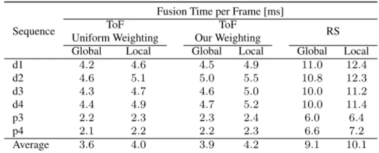
Building on the assumption thatVIOtypically runs onboard a smallUAVfor frame-to-frame egomotion estimation and that any interaction of a robotic manipulator with the environment is to be performed within the Field of View (FoV) of the onboard sensors, this paper proposes to utilize aCPU-capable dense reconstruction framework. To this end, besides running the VIO, theUAVis assumed to be equipped with a depth camera (i.e. experiments are presented with both an RGB-D and aToFcamera). AsVIOis generally prone to drift, an adjustable time-horizon∆twas introduced, which controls the removal of possibly outdated parts of the reconstruction. This permits the viewpoint of the sensor to fluctuate slightly, e.g. due to wind gusts, without loosing the gathered information about the scene structure, while resetting any volumetric blocks of the dense scene representation when they do not receive an update within
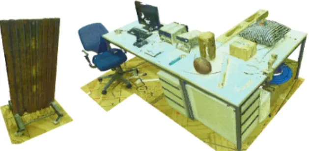
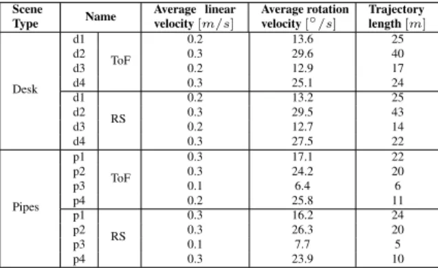
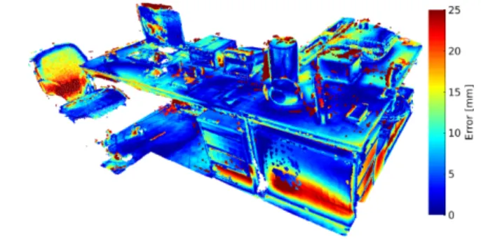
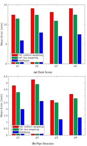
∆tin the past. This helps to avoid artifacts arising from drift in the pose estimation when revisiting parts of the scene following longer exploratory motions. In order to allow the incor- poration of uncertainty information in the depth measurements, a computationally lightweight weighting scheme was introduced, which resulted in an average decrease of the reconstruction error of 10% on real data using aToFcamera. Due to the lack of real-world datasets containing
2.1 Research Contribution
high-quality visual-inertial data, depth data as well as pose and scene ground-truth, a dedicated dataset was created and made publicly available to the community1. The dataset consists of two different scenes and contains hand-held sequences with a sensor-rig equipped with a Visual- Inertial sensor [101] for high-quality visual-inertial data and either the Intel RealSense R200 or the CamBoard pico flexx from PMD for depth perception (only one depth sensor was mounted at a time to avoid inferences between them). The scene ground truth was captured using a high precision laser measuring system along with the pose ground truth from a motion capturing system, thus enabling quantitative evaluation of the algorithm on real data.
Interrelations
Although the method presented inPaper Iis developed on a single-agent basis, as the required inputs are the sensor poses in six Degrees of Freedom (DoF) along with a noisy point cloud to represent the scene, the approach can be employed as an add-on to the approaches inPaper IIIandPaper V, which produce six-DoFposes at frame-rate. Furthermore, the approaches in Paper IVandPaper Vboth estimate a variable-stereo configuration, which could be utilized to compute a disparity image to serve as input for this work.
Paper II: Towards Globally Consistent Visual-Inertial Collaborative SLAM
M. Karrer and M. Chli. Towards Globally Consistent Visual-Inertial Collaborative SLAM. In Proceedings of the IEEE International Conference on Robotics and Automation (ICRA), pages 3685–3692, 2018
Context
While visual-inertial methods performing odometry have reached a considerable maturity, full SLAMsystems closing loops, performing global corrections and re-using previously mapped information are mainly limited to vision-only systems (either monocular or stereo) [96,97].
The first approach demonstrating the re-use of mapped information in a monocular-inertial setup was introduced by Mur-Artal et al., dubbed as VI-ORBSLAM [98]. Their work shed light into some of the biggest issues in the fullVI-SLAM, namely the proper estimation of accelerometer biases, their initialization and the scalability of the approach. Moreover, while collaborative frameworks performing purely visualSLAMexist [43,119,149], at the time there was a complete lack of collaborative approaches fusing visual and inertial measurements in the estimation. Inspired by the potential of such systems,Paper IIemployed a nominalVIOsystem with minimal modifications to investigate visual-inertial global mapping for one and two agents achieving close to real-time performance.
1https://v4rl.ethz.ch/research/datasets- code/V4RL- Dense- Reconstruction- Dataset.
html
17
2 Contribution
Contribution
This paper proposes a framework to combine information from potentially multiple agents into a singleSLAMmap; assuming that each agent runs nominal keyframe-basedVIO, keyframe information gets communicated to a central server, where correspondences across keyframes are established and optimization is performed to fuse this data into a global map, contributing towards creating globally consistentSLAMmaps from multiple agents. In contrast to [98], the current state of theIMUbias is consulted both for determining a successful initialization as well as for the decision whether a keyframe can be removed in order to increase the computational scalability of the system. While only considering the back-end part of the system, results on the EuRoC benchmarking dataset [11] demonstrates improvements on the trajectory error of at times over 50% over the state of the art, indicating the potential of the approach. Conducting experiments with two agents, in this work, we could demonstrate that even in the absence of inertial constraints between the agents, a consistent estimate of their trajectories and the scale in the estimates can be maintained and at times, even improving the accuracy compared to the single-agent trajectories.
Interrelations
This paper aims at investigating how to obtain a globally consistent trajectory and scene map using data fromVIOrunning onboard one or multiple agents. In the evaluation, considerable improvements over the state of the art could be demonstrated on the simpler datasets, however, the returns were diminishing with more difficult sequences. Furthermore, the sequential nature of the implementation along with the exhaustive local optimization of the incoming keyframes rendered the approach far from real-time capable for more than two agents. InPaper III, these shortcomings are addressed, first, by introducing a tailored front-end odometry on each agent eliminating the need for the local optimization to be carried out by the server and second, by implementing parallelized data handling on the server.
Paper III: CVI-SLAM – Collaborative Visual-Inertial SLAM
M. Karrer*, P. Schmuck*, and M. Chli. CVI-SLAM - Collaborative Visual-Inertial SLAM, IEEE Robotics and Automation Letters, 3(4):2762-2769, 2018
∗indicates equal contribution Context
While inPaper IIthe centralized, consistent fusion of visual-inertial data obtained from two agents could be demonstrated, the serialized implementation and the exhaustive local optimiza- tion prohibits the real-time operation of the approach for more than one agent. Even though this limitation could be relaxed by increasing the level of parallelism in the implementation, as suggested in [43], the lack of information flowing from the server back to the agents limits the level of collaboration of the approach to collaborative mapping. There are a few works effec- tively addressing the use of two-way communication schemes to allow the agents the re-use of information. For example the RGB-D based system in [114] proposes to completely outsource
2.1 Research Contribution
all operations except for the tracking to a server, limiting the autonomy of the agents, as any loss of connection inevitably leads to a failure of the system. To the contrary, the work of [33] pro- poses to run the completeSLAMpipeline on each agent, including loop-closure detection and global optimization, while additionally exchanging data with a central server. While such an approach ensures the autonomy of the agents even with an unreliable connection to the server, it misses out on computational savings of outsourcing heavy, but non-time-critical computations (such as global optimization) to the server. As a result, this system’s applicability is limited to agents permitting such heavy computation onboard. An architectural middle-way was proposed in [119,120], where the agents keep a map of limited horizon providing them with estimation autonomy even in the absence of contact to the server. The server accumulates the data from all agents and fuses them, where possible, via loop closure detection and global optimization. By communicating back to the agents, the server allows the sharing and re-use of information from all participating agents whose maps can be fused together if their trajectories meet. However, the system [120] is designed to work only as a monocular system, therefore suffering from the typical shortcomings such as sensitivity to abrupt motions and the absence of an estimate of the metric scale. As it is well known, the metric scale can be obtained by fusingIMUmeasurements [10], therefore, transitioning the system from a monocular to a visual-inertial would bring the system closer to real-world robotic applicability. However, such a transition is not trivial and requires significant modifications in both the back-end optimization on the server-side as well as a complete re-design of the odometry front-end.
Contribution
Building on top of the system architecture of [120], both the employed front-end odometry as well as the optimization algorithms were re-designed in order to incorporate theIMUinforma- tion. In both the agent’s front-end odometry as well as for the global collaborative estimate, the well established on-manifoldIMUpre-integration scheme [42] is implemented, building a complete collaborative monocular-inertialSLAMsystem. To the best of the authors’ knowl- edge, CVI-SLAM2is the first collaborativeSLAMsystem using visual-inertial data along with two-way communication between the participating agents and the server, bringing collaborative SLAMa step closer to real-world applicability. The experimental evaluation presented inPaper IIIdemonstrates that CVI-SLAM performs comparably to state-of-the-art visual-inertialSLAM systems, while outperforming them in a collaborative setup. Additionally, inPaper IIIthe ef- fect of the two-way communication is demonstrated as the resulting accuracy of the frame-wise pose tracking could be improved online by using the collaborative scheme to share information.
Even though as compared to [120], alsoIMUdata needs to be communicated to the server, the improved robustness of the visual-inertial front-end allows the use of fewer visual features, leading to decreased overall network traffic.
Implementing the whole system from scratch, the contributions claimed in this thesis are mainly focused on the design and the implementation of the optimization related algorithms running on the agents as well as the server, leading to a re-usable and extendable library forSLAM related optimization. Furthermore, besides the incorporation of theIMUinformation into the optimization, the tight integration into the front-end were implemented as result of this thesis.
2Collaborative Visual-Inertial SLAM
19
2 Contribution
Interrelations
Paper IIIcombines the findings fromPaper IIwith the architecture of the monocular collabora- tiveSLAMsystem [120]. Using the efficient communication architecture and the server-sided map reconstruction approach of [120] along with the global optimization presented inPaper II, real-time performance with multiple agents is possible. On the agent side, a local map opti- mization inspired by the local optimization used inPaper IIis implemented, however, as it is run on each agent, compared toPaper IIthe computational load of this action is distributed, sparing the server from additional computational load. While simple heuristics were employed to remove redundant keyframes from the system in order to improve the system’s scalability, the computational bottleneck of the system is the global bundle adjustment. Depending on the available computational architecture, e.g. on a cloud-computer, the scalability of the global bun- dle adjustment could be boosted by employing the distributed optimization method presented inPaper Vin order to parallelize the optimization.
Paper IV: Collaborative 6DoF Relative Pose Estimation for Two UAVs with Overlapping Fields of View
M. Karrer, M. Agarwal, M. Kamel, R. Siegwart, and M. Chli. Collaborative 6DoF Relative Pose Estimation for Two UAVs with Overlapping Fields of View. InProceedings of the IEEE International Conference on Robotics and Automation (ICRA), pages 6687–6693, 2018
Context
By the means of triangulation on pairs of images captured with a stereo camera, the scene depth can be estimated at a particular time step rendering this as a powerful tool forSLAM and scene reconstruction. However, the choice of the stereo baseline is crucial for the effective range of a stereo camera, as too big baselines lead to problems with occlusions or lack of sufficient overlap for triangulation, while too small baselines produce a high uncertainty in the depth estimation. Having the possibility to adjust to a suitable baseline on the fly, based on the depth and accuracy requirements of the task at hand holds a big potential [50]. In a loose sense, such a variable stereo setup can be achieved by using two robots equipped each with a monocular camera, which by arranging themselves in a certain way are able to adjust the stereo baseline. This idea was proposed in [5], where the authors showed that using twoUAVs both equipped with cameras andIMUs it is possible to compute the relative transformation between the cameras in metric scale. Furthermore, knowing the relative transformation between two robots allows them to be controlled to perform certain configurations for example in order to transport an object as shown in Fig.1.3. InPaper IV, a lightweight approach to estimate the relative transformation between two cameras by fusing odometry information along with vision measurements is presented.
Contribution
Picking up on the idea in [5], a lightweight estimation framework was developed inPaper IV, capable to estimate the relative transformation between two robots based on their odometry
2.1 Research Contribution
Figure 2.2:The proposed parameterization of the stereo baseline formed by the twoUAVs carrying one monocular camera each, defining a state vector containing a bearing vector with inverse distance scaling. This parameterization captures the underlying uncertainty (indicated with the light blue ellipses) of the estimation problem from pairwise image measurements of scene landmarks (here, denoted with a star).
information and view-overlap. InPaper IV, anEKFwas chosen to fuse the robots’ odometry estimates along with their monocular vision measurements. The inclusion of a small number of 3D landmarks in the filter state allowed to employ a guided correspondence search resulting in an average processing frame-rate of 74Hz, while the overall generated network traffic is below 0.5MB/s. In order to capture the underlying uncertainty of the relative transformation between the robots, inPaper IVit is proposed to parameterize the transformation as a standard rotation along with a bearing vector with an inverse-depth parameter for the baseline as shown in Fig.
2.2.
Interrelations
Paper IVpresents the basic idea that was later on extended inPaper Vto a fully distributed system. Although the main contribution ofPaper IV, namely the proposed parameterization of the relative stereo transformation, was not further employed, the realization that a system based on using individual agents’ odometries can only be as robust as these odometries considered in isolation, lead to the development of the system inPaper V. For example, considering the parametrization illustrated in Fig.2.2, it becomes clear that the use of a distance measurement between the agents significantly reduces the uncertainty of the system, which is specifically addressed inPaper V.
Paper V: Distributed Variable-Baseline Stereo SLAM from two UAVs
M. Karrer and M. Chli. Distributed Variable-Baseline Stereo SLAM from two UAVs, Submitted toIEEE Transactions on Robotics, 2020
21
2 Contribution
Context
NowadaysVIOandVI-SLAMapproaches show remarkable performance and robustness in various scenarios from hand-held devices, indoors toUAVs employed in large-scale disastrous areas. Furthermore, as shown inPaper IIandPaper III, fusing data captured and processed from multiple robotic agents can improve the overall quality of the estimates when fused in a comprehensive, collaborative manner. However, any failures of the agents’ local odometries have a devastating effect and rendering the affected agents unaware of both the other agents and their ego-motion. On the other hand, as demonstrated impressively in [149], for highly dynamic scenes, a tight collaboration between agents can enable to overcome situations in collaboration where a single agent would fail to obtain a reasonable estimate. One of the known failure cases forVI-SLAM, for example, is when all scene points are far away from the agent as it is the case forUAVs flying at high altitudes [57,58]. Using the idea of a variable baseline stereo setup employing twoUAVs, each equipped with a monocular camera to form a stereo camera as inPaper IV. However, in contrast to the approach inPaper IV, which relies on a functioning odometry for both agents individually, inPaper Va joint estimator is proposed, which fed with relative distance measurements between the agents as they can be obtained viaUWBmodules, is capable of producing a reliable, metrically scaled pose estimate for both agents.
Contribution
InPaper V, a novel sensor fusion framework fusing relative distance information (e.g. as ob- tained usingUWBmodules) between twoUAVs together with the visual-inertial information from the twoUAVs. The framework enables to reliably estimate the ego-motion of both agents at absolute scale even at high altitudes in real-time. The frame-wise tracking performed on each agent utilizes anEKFfusing the inertial data together with the visual observations of the estimated map points, allowing to have a low latency pose-estimation latency. In order to fuse the relative distance measurements, inPaper V a sliding-window bundle adjustment with a continuous-time Z-spline based trajectory representation is proposed. To allow each agent to hold its own estimate of the map such that their autonomy of estimates is not compromised by potential network delays while maintaining consistency across the agents, it is proposed to employ an asynchronous, consensus-based optimization scheme on the basis of [107] for the first time to the best of the author’s knowledge. Even though inPaper V, the proposed opti- mization scheme is mainly employed to obtain a consistent estimate between the two agents, the approach has significant potential in allowing scaling up global bundle adjustment for a large number of agents as the problem can be approached in a decentralized fashion enabling a high degree of parallelism. Using the estimated poses, a high-level formation controller was developed, allowing to automatically adjust the virtual stereo-baseline between the two agents based on the estimated scene requirements. In the thorough evaluation using photo-realistic simulations, the advantage of the proposed approach over state-of-the-art fixed stereo-inertial estimators at higher altitudes could be demonstrated.
2.2 List of Supervised Students
Interrelations
The approach presented inPaper Vcomplements the approaches inPapers II-IV, as it specif- ically addresses some shortcomings of the single-agentVIOemployed in these papers. The proposed distributed optimization approach inPaper V, holds large potential to scale up the bundle adjustment problem to a larger amount of data, as the overall problem can be split into smaller subproblems allowing to increase the parallelization of the computations. Such a paral- lelization could be used to address the computational bottlenecks inPaper IIandPaper III. The proposed in lightweight localizationEKFapproach inPaper V, can potentially be employed for the frame-wise tracking inPaper IIIfor the employment on computationally weaker hardware, such as smartphones.
2.2 List of Supervised Students
Master Theses
Master students, 6-month projects, full-time
• Agarwal, Mohit (Fall 2016): “Collaborative Visual-Inertial based Sensing using Multiple UAVs”
• Lampart, Andrea (Fall 2016): “Monochromatic SLAM augmented with an Event-Based Camera”
• Li, Kailai (Fall 2016): “Towards globally consistent,dense 3D reconstruction onboard a UAV”
• Müller, Fabian (Spring 2017): “Event-based pose tracking using patterns learnt during runtime”
• Bartolomei, Luca (Fall 2017): “3D Radiation Mapping using a small UAV”
• Thurnhofer, Franz (Fall 2017): “Large-scale Dense Scene Reconstruction from Multiple UAV”
• Böröndy, Aron (Spring 2018): “Visual-Inertial SLAM for consumer level sensors”
• Herbst, Constantin (Spring 2018): “Event-Based Visual Odometry Using Line Features”
• Hug, David (Spring 2018): “Event-based SLAM in Continuous Time”
• Russi, Mario (Spring 2018): “Collaborative State Estimation for High Altitudes using two UAVs”
• Schmidig, David (Spring 2018): “Visual SLAM for Dynamic Environments”
• Greter Rafael (Fall 2018): “Visual Tracking for UAVs”
23
2 Contribution
• Strässle, Timo (Fall 2018): “Towards Collaborative SLAM using Smartphones”
• Perraudin, Jonathan (Fall 2019): “Towards Collaborative SLAM using Smartphones”
• Zuidema, Christoph (Fall 2019): “Autonomous Radiation Mapping using multiple UAVs”
• Pensotti, Sara (Spring 2020): “Autonomous Multi-Robot Exploration of Partially Un- known Environments”
• Ziegler, Thomas (Spring 2020): “Distributed UAV Formation Estimation via Pairwise Distance Measurements”
Semester Theses
Master students, 3-4-month projects, part-time
• Ziegler, Andreas (Fall 2016): “Map Fusion for Collaborative UAV SLAM”
• Schönbächler, Lukas (Spring 2017): “ROS Toolbox for visual sensor calibration”
• Ziegler, Thomas (Spring 2018): “High Accuracy Visual Inertial SLAM for Autonomous Navigation of small UAVs”
• Schaller, Sebastian (Fall 2018): “Feature Tracking for Event-based Cameras”
• Ginting, Fadhil (Spring 2019): “UAVs Formation Estimation using UWB Measurements”
• Ritz, Kamil (Spring 2019): “Rolling Shutter and Time Offset Compensation for Visual- Inertial-Odometry”
• Roth, Timo (Spring 2019): “Active Vision for Relative Pose Estimation”
• Sempertegui, Emilk (Spring 2019): “Optimization-based Path Planning for Autonomous Robot Navigation”
• Tearle, Ben (Spring 2019): “Collaborative UAV SLAM”
• Oberson, Lucien (Fall 2019): “Spline-Based Direct IMU Integration for SLAM”
• Schönbächler, Sacha (Fall 2019): “Efficient Map Re-Use for Collaborative SLAM”
• Li, Cliff (Fall 2019): “Towards Collaborative SLAM – Robustifying Visual-Inertial Odom- etry”
• Davide, Mambelli (Spring 2020): “Multi-agent path planning for active sensings”
• Yunfan, Gao (Spring 2020): “Multi-Sensor Fusion in Continuous Time”
• Bayerle, Michael (Spring 2020): “IMU-Handling for Smartphone-based Visual-Inertial Odometry”
![Figure 1.5: Illustration taken from [5], showing the idea of using two UAVs, equipped both with monocular cameras to form a variable baseline stereo camera.](https://thumb-eu.123doks.com/thumbv2/1library_info/5327549.1680379/22.629.176.483.118.238/figure-illustration-showing-equipped-monocular-cameras-variable-baseline.webp)
![Figure 4.7: Average errors of the local reconstructions using poses from VI-SLAM [83]](https://thumb-eu.123doks.com/thumbv2/1library_info/5327549.1680379/55.629.142.461.116.331/figure-average-errors-local-reconstructions-using-poses-slam.webp)