Veröffentlichungen der DGK
Ausschuss Geodäsie der Bayerischen Akademie der Wissenschaften
Reihe C Dissertationen Heft Nr. 783
Yan Xu
GNSS Precise Point Positioning
with Application of the Equivalence Principle
München 2016
Verlag der Bayerischen Akademie der Wissenschaften
ISSN 0065-5325 ISBN 978-3-7696-5195-9
Veröffentlichungen der DGK
Ausschuss Geodäsie der Bayerischen Akademie der Wissenschaften
Reihe C Dissertationen Heft Nr. 783
GNSS Precise Point Positioning with Application of the Equivalence Principle
Von der Fakultät VI – Planen Bauen Umwelt der Technischen Universität Berlin zur Erlangung des akademischen Grades Doktor der Naturwissenschaften (Dr. rer. nat.)
genehmigte Dissertation
von M.Sc. Yan Xu aus Fujian/China
München 2016
Verlag der Bayerischen Akademie der Wissenschaften
ISSN 0065-5325 ISBN 978-3-7696-5195-9
Ausschuss Geodäsie der Bayerischen Akademie der Wissenschaften (DGK) Alfons-Goppel-Straße 11 ! D – 80539 München
Telefon +49 – 89 – 230311113 ! Telefax +49 – 89 – 23031-1283 /-1100 e-mail post@dgkt.badw.de ! http://www.dgk.badw.de
Vorsitzender: Prof. Jürgen Oberst Gutachter: Prof. Harald Schuh
Prof. Luisa Bastos, Universität Porto Prof. Roman Galas
Tag der wissenschaftlichen Aussprache: 08.09.2016
Diese Dissertation ist auf dem Server der DGK unter <http://dgk.badw.de/>
sowie auf dem Server der TU Berlin unter <https://depositonce.tu-berlin.de/handle/11303/5918>
elektronisch publiziert
© 2016 Bayerische Akademie der Wissenschaften, München
Alle Rechte vorbehalten. Ohne Genehmigung der Herausgeber ist es auch nicht gestattet,
die Veröffentlichung oder Teile daraus auf photomechanischem Wege (Photokopie, Mikrokopie) zu vervielfältigen.
ISSN 0065-5325 ISBN 978-3-7696-5195-9
Abstract i
Abstract
In the last decade Precise Point Positioning (PPP) has become a powerful and widely used technique for positioning by means of Global Navigation Satellite System (GNSS) in geodetic/scientific and civil/daily applications. Meanwhile, the equivalence principle of GNSS data processing has been developed and can now be easily explained and accepted since it was firstly algebraically pointed out in 2002. The objective of this thesis is to explore high-performance PPP algorithms and to develop GNSS algorithms with application of the equivalence principle. The core research and contributions of this thesis are summarized as follows.
In this thesis it is the first time that the specific equivalence of un-differenced and time differencing PPP algorithms is proved theoretically on the basis of the equivalence principle and the equivalence property of un-differenced and differencing algorithms. Meanwhile, as a supplement to the equivalence property of the triple differences, an alternative method is proposed and derived to prove the equivalence between triple differences and zero-difference which up to now was missing.
As a consequence of above conducted theoretical study, a time differencing PPP algorithm based on the equivalence principle is derived and can be used to obtain the coordinates difference and average velocity between two adjacent epochs. Such a time differencing PPP algorithm is able to provide both position and velocity results from the phase and code observations and is expected to be beneficial for applications, such as airborne gravimetry or earthquake monitoring, and could also be an efficient method to detect cycle slips in data processing.
The influence of tropospheric delay on PPP, especially in the context of observations in the polar region or with low elevation cut-off angles, where the position results of the observations are more significantly affected by tropospheric delay, is analyzed and a methodology for minimizing its effect is proposed. Actual meteorological data are used and proved to be beneficial for improving PPP precision in the Antarctic region. The effect of tropospheric horizontal gradient correction on PPP is also analyzed and verified to remarkably improve PPP precision under lower elevation cut-off angles and higher humidity conditions.
A priori constrained PPP algorithms are proposed and derived in this thesis to improve the efficiency and precision of PPP. The a priori information concerning the geometric and physical properties of observations, which is known with a certain a priori precision, is applied in the PPP algorithms. The contribution of different a priori information constraints on different parameters to PPP solution is analyzed and validated. The a priori constraints as employed in the PPP are specified according to coordinates-, receiver clock offset-, tropospheric delay- and ambiguities-constraints, respectively. The validation of the derived PPP algorithms shows a significant improvement concerning convergence time and positioning accuracy. Moreover, the applications of different constraints under specific conditions are discussed and validated.
A multi-constellation combined PPP algorithm based on the equivalence principle is proposed and derived in this thesis. With such an algorithm, the exponentially increased computational load of the traditional multi-GNSS PPP algorithm can be reduced to the single linear increase when more GNSS satellites are available and used for combined computation. In case of GPS/BDS combination, a method which can speed up the determination of the ambiguities parameters of BDS through applying the contribution of GPS observations is proposed to significantly reduce the convergence time in BDS PPP.
The GPS/BDS combined PPP algorithm with inter-system bias (ISB) parameter is also derived. Using the estimated ISB as a priori constraint in the GPS/BDS combined PPP is proposed. The result demonstrates that the a priori constraint of ISB shows superiority in the convergence time of PPP processing and can mainly improve the positioning accuracy in E component.
In traditional combined PPP it is difficult to adaptively adjust the contribution of each single system to the combination through constructing total calculation, and it will lead to the deterioration in the combination accuracy. In this context, the adaptively combined PPP algorithms based on the equivalence principle are proposed and derived, which can easily achieve an adaptive adjustment of weight ratio of each system in the multi-GNSS combination. By using the posteriori covariance matrix of the shared parameters of each single system and the Helmert variance components to adaptively adjust the weight ratio of each system, the derived algorithms can improve the accuracy of combination significantly, compared to combined PPP with identical weight ratio.
The developed algorithms are net applicable and can be used for cloud computation for internet GNSS service which is considered relevant for possible commercial applications.
Keywords: GNSS; Precise Point Positioning; Sequential Least Squares; Equivalence Principle;
Equivalently Eliminated Equation; Time Differencing PPP; Triple Differences; Tropospheric Delay;
Meteorological Data; Horizontal Gradient; A Priori Constraint; Coordinates Constraint; Receiver Clock Offset Constraint; Tropospheric Delay Constraint; Ambiguities Constraint; Multi-GNSS Combined PPP;
Fast BDS Ambiguity Determination; Inter-system Bias; Adaptively Combined PPP; Posteriori Covariance;
Variance Component Estimation
Zusammenfassung iii
Zusammenfassung
In den letzten zehn Jahren entwickelte sich das Verfahren des Precise Point Positioning (PPP) zu einer leistungsstarken und weit verbreiteten Technik in der Positionsbestimmung mittels des Global Navigation Satellite System (GNSS) in geodätischen/wissenschaftlichen und zivilen/täglichen Anwendungen. Ein wichtiges Grundprinzip der GNSS-Datenverarbeitung ist das Äquivalenzprinzip der GNSS-Datenverarbeitung, das 2002 erstmals beschrieben wurde. Das Ziel dieser Arbeit ist die Untersuchung von Hochleistungs-PPP-Algorithmen und die Entwicklung von GNSS-Algorithmen unter Anwendung des Äquivalenzprinzips. Der Kern der Untersuchungen und die Beiträge dieser Arbeit lassen sich wie folgt zusammengefassen.
Aufbauend auf dem Äquivalenzprinzip und den Äquivalenz-Eigenschaften von nicht-differenzierenden und differenzierenden GNSS-Algorithmen wird in dieser Arbeit zum ersten Mal die spezifische Gleichwertigkeit von nicht-differenzierenden und zeitdifferenzierenden PPP-Algorithmen theoretisch bewiesen. In diesem Zusammenhang beschreiben wir – als Ergänzung zu den Äquivalenz-Eigenschaften der Tripel-Differenzen - eine bis jetzt noch nicht existierende alternative Methode zum Beweis der Äquivalenz von Tripel-Differenzen und undifferenzierten Beobachtungen.
Aufbauend auf der oben erwähnten theoretischen Untersuchung wurde ein zeitlich differenzierender PPP-Algorithmus abgeleitet, der auf dem Äquivalenzprinzip beruht und der dazu benutzt werden kann, die Koordinatendifferenz und die mittlere Geschwindigkeit zwischen benachbarten Beobachtungszeitpunkten zu bestimmen. Ein solcher zeitlich differenzierender PPP-Algorithmus ist in der Lage, sowohl Position als auch Geschwindigkeit aus Phasen- und Code-Beobachtungen zu liefern. Dieser Algorithmus sollte für Anwendungen wie Fluggravimetrie oder Erdbeben-Überwachung nützlich sein und stellt eine effiziente Methode zur Erkennung von Cycle-Slips dar.
Diese Arbeit umfasst auch Analysen des Einflusses der Troposphärischen Signalverzögerung auf das PPP, vor allem im Blick mit Beobachtungen in den Polarregionen oder im Fall niedriger Höhengrenzwinkel (sog. Cut-off-Winkel), wo die Positionsbestimmung sehr stark von der Troposphärischen Signalverzögerung beeinflusst ist. In diesem Zusammenhang wird eine Methodologie zur Minimierung des Troposphäreneinflusses vorgeschlagen. Es werden reale meteorologische Daten verwendet und es wird gezeigt, dass dies zur Verbesserung der Präzision des PPP in antarktischen Regionen von Vorteil ist. Außerdem wird der Effekt der troposphärischen Horizontalgradienten-Korrektur analysiert und es wurde bewiesen, dass diese Methode zu einer deutlichen Verbesserung des PPP im Fall niedriger Cut-off-Winkel und hoher Luftfeuchtigkeit führt.
In dieser Arbeit werden PPP-Algorithmen mit A-priori-Nebenbedingungen (sog. Constraint) vorgeschlagen und abgeleitet, um die Effizienz und Präzision des PPP zu verbessern. Die in den PPP-Algorithmen angewandten A-priori-Informationen betreffen die geometrischen und physikalischen Eigenschaften von Beobachtungen, von denen vorab eine bestimmte Genauigkeit bekannt ist. Der Einfluss von verschiedenen A-priori-Nebenbedingungen auf verschiedene Parameter innerhalb der PPP-Lösung wird analysiert und validiert. Diese in den PPP-Algorithmen angewandten A-priori-Bedingungen sind aus Nebenbedingungen für Koordinaten, Empängeruhren-Offsets, Troposphären-Verzögerung und Ambiguities abgeleitet. Die Validierung dieser Algorithmen zeigt eine deutliche Verbesserung bezüglich der Konvergenzzeit und der Genauigkeit in der Positionsbestimmung. Ferner wird die Anwendung
verschiedener Constraints unter spezifischen Bedingungen diskutiert unf validiert.
In dieser Arbeit wurde ein kombinierter PPP-Algorithmus für Multi-Satellitensysteme vorgeschlagen und abgeleitet, der auf dem genannten Äquivalenzprinzip beruht. Mit einem solchen Algorithmus kann die exponentiell ansteigende Computerlast des traditionellen Multi-GNSS-PPP dahingehend reduziert werden, dass es nur einen einfachen linearen Anstieg gibt, wenn mehr GNSS-Satelliten einbezogen werden. Für den Fall der Kombination von GPS mit dem chinesischen Beidou-System (BDS) wird eine Methode vorgeschlagen, die die Berechnung der Ambiguity-Parameter für das BDS-System durch Beitrag von GPS-Beobachtungen schneller beschleunigt. Diese Methode reduziert die Konvergenzzeit im BDS-PPP deutlich. Außerdem wird im Fall der Kombination von GPS und BDS ein Inter-System-Bias (ISB) abgeleitet. Es wird vorgeschlagen, diesen ISB als A-priori-Nebenbedingung in das PPP bei der Kombination von GPS und BDS einzuführen. Dadurch ergeben sich überlegene Resultate für die Konvergenzzeit in der PPP-Prozessierung und die Positionsgenauigkeit in der Ost-Komponente kann verbessert werden.
Im traditionellen kombinierten PPP-Verfahren ist es schwierig, den Beitrag jedes einzelnen Systems zur Kombination durch Konstruktion einer Gesamtlösung adaptiv anzugleichen, was zur Verschlechterung in der Kombinationsgenauigkeit führt. In diesem Zusammenhang wurde ein adaptiv kombinierter PPP-Algorithmus vorgeschlagen und entwickelt, der auf dem Äquivalenzprinzip beruht. Dieser Algorithmus ermöglicht eine einfache adaptive Ausgleichung der relativen Wichtungen für jedes Satelliten-System in der Multi-GNSS-Kombination. Durch Nutzung der a-posteriori Kovarianz-Matrix, die für alle gemeinsamen Parameter der einzelnen Satelliten-Systeme aufgestellt wurde und durch die Anwendung der Helmertschen Varianzkomponenten-Schätzung zur adaptiven Ausgleichung der relativen Wichtungen der einzelnen Systeme kann die Genauigkeit der Kombination im Vergleich zum PPP mit identischen Relativgewichten deutlich gesteigert werden.
Die entwickelten Algorithmen sind über das Internet anwendbar und könnten für Cloud-Berechnungen im Rahmen eines Internet-GNSS-Dienstes verwendet werden, was für mögliche kommerzielle Anwendungen von Bedeutung sein könnte.
Stichworte: GNSS; Precise Point Positioning; Sequenzielle Kleinste Quadrate; Äquivalenzprinzip;
Äquivalent eliminierte Gleichung; Zeitlich differenzierendes PPP; Trip-Differenzen; Troposphärische Verzögerung; Meteorogische Daten; Horizontaler Gradient; A-priori-Nebenbedingung;
Koordinaten-Nebenbedingung; Empfängeruhren-Offset-Nebenbedingung;
Troposphären-Verzögerungs-Nebenbedingung; Ambiguity-Nebenbedingung; Kombiniertes Multi-GNSS-PPP; Schnelle BDS-Ambiguity-Bestimmung; Intersystem-Bias; Adaptiv kombiniertes PPP;
A-prosteriori Kovarianz; Varianzkomponenten-schätzung
Table of Contents v
Table of Contents
Abstract ... i
Zusammenfassung ... iii
Table of Contents ... v
List of Abbreviations ... ix
List of Figures ... xi
List of Tables ... xiii
1 Introduction ... 1
1.1 Research Background and Motivation ... 1
1.2 The Main Research Contents and Overview of the Dissertation ... 3
1.3 The Main Contributions of the Dissertation ... 4
2 Equivalence Principle of Precise Point Positioning ... 7
2.1 Introduction ... 7
2.2 Commonly Used Adjustment and Filtering Algorithms in PPP ... 7
2.2.1 Least Squares Adjustment ... 7
2.2.2 Sequential Least Squares Adjustment ... 8
2.2.3 Kalman Filter ... 10
2.3 Equivalence Principle and Equivalently Eliminated Observation Equation ... 12
2.4 Equivalence of Un-differenced and Time Differencing PPP Algorithms ... 15
2.5 Equivalence of Un-differenced and Triple Differences Algorithms ... 17
2.6 Time Differencing PPP Based on the Equivalence Principle ... 18
2.7 Conclusions ... 20
3 Influence of Tropospheric Delay on Precise Point Positioning ... 23
3.1 Introduction ... 23
3.2 Tropospheric Delay Model ... 24
3.2.1 Zenith Tropospheric Delay ... 24
3.2.2 Mapping Functions ... 25
3.3 Comparison of Tropospheric Delays Based on GPT2 and Actual Meteorological Observations ... 25
3.3.1 Data Preparation ... 25
3.3.2 Comparison of Zenith Hydrostatic Delays ... 26
3.4 Effect of Meteorological Data on Precise Point Positioning ... 27
3.4.1 Tropospheric Delay Estimation ... 27
3.4.2 Data Analysis and Results ... 28
3.5 Effects of A Tropospheric Horizontal Gradient Model ... 31
3.5.1 Tropospheric Horizontal Gradient Model ... 31
3.5.2 Data Analysis and Results ... 31
3.6 Conclusions ... 34
4 A Priori Constrained Precise Point Positioning Algorithms ... 35
4.1 Introduction ... 35
4.2 Analytic Contribution of Different Constraints on Parameters to PPP Solution ... 35
4.2.1 A Priori Constrained PPP Algorithms ... 35
4.2.2 Contribution Analysis of the Constraints to PPP ... 37
4.3 Applications of Different Constraints under Specific Conditions ... 38
4.3.1 Application of A Priori Constrain to Coordinates ... 38
4.3.2 A Priori Constrain to Receiver Clock Offset ... 40
4.3.3 A Priori Constrain to Tropospheric Delay ... 41
4.3.4 A Priori Constrain to Ambiguities... 42
4.4 Examples and Analysis... 42
4.4.1 PPP with Coordinates Constraint ... 42
4.4.2 PPP with Receiver Clock Offset Constraint ... 45
4.4.3 PPP with Tropospheric Delay Constraint ... 46
4.4.4 PPP with Ambiguities Constraint ... 47
4.5 Conclusions ... 49
5 Multi-Constellation Combined Precise Point Positioning Based on the Equivalence Principle ... 51
5.1 Introduction ... 51
5.2 The Conventional Multi-Constellation Combined PPP Algorithm ... 52
5.3 Multi-Constellation Combined PPP Algorithm Based on the Equivalence Principle ... 53
5.3.1 Multi-Constellation Combined PPP Algorithm ... 53
5.3.2 Specific Analysis under Static and Kinematic Conditions... 56
5.3.3 Efficiency Comparison of the Multi-GNSS Combined PPP Algorithms ... 57
5.3.4 Examples and Analysis ... 58
5.4 Fast BDS Ambiguity Determination Based on the Contribution of GPS Observations ... 64
5.4.1 Introduction ... 64
5.4.2 Methodology ... 65
5.4.3 Example and Analysis ... 67
5.5 GPS/BDS Combined PPP Algorithm with Inter-system Bias Parameter ... 69
5.5.1 Methodology ... 69
5.5.2 Example and Analysis ... 70
5.6 Conclusions ... 72
Table of Contents vii
6 Adaptively Multi-Constellation Combined Precise Point Positioning Based on the Equivalence
Principle... 75
6.1 Introduction ... 75
6.2 Main Progress of the Adaptively Robust Theory in Satellite Navigation and Positioning ... 75
6.2.1 Principle of the Adaptively Robust Filter ... 75
6.2.2 Determination of the Robust Equivalent Weight Matrix and the Adaptive Factor ... 76
6.2.3 Special Estimators... 78
6.2.4 Development of the Adaptively Robust Filter and Its Applications ... 79
6.3 Adaptively Robust PPP of A Single System Based on the Equivalence Principle ... 80
6.4 Adaptively Multi-Constellation Combined PPP Based on the Equivalence Principle ... 81
6.4.1 Methodology ... 81
6.4.2 Example and Analysis ... 83
6.5 Adaptively Combined PPP Based on the Variance Component Estimation ... 84
6.5.1 Methodology ... 84
6.5.2 Example and Analysis ... 87
6.6 Conclusions ... 88
7 Summary and Future Work ... 89
7.1 Summary ... 89
7.2 Future Work ... 90
References ... 93
Acknowledgements ... 101
List of Abbreviations ix
List of Abbreviations
BDS the Chinese BeiDou Navigation Satellite System
CNAGA China National Administration of GNSS and Applications
DD Double Differences
DIA Detection Identification and Adaptation
ESA European Space Agency
ERP Earth Rotation Parameter FOC Full Operational Capability
Galileo the European Union Satellite Navigation System GEO Geostationary Earth Orbit
GFZ GFZ German Research Centre for Geosciences GLONASS the Russian GLObal NAvigation Satellite System
GMF Global Mapping Function
GNSS Global Navigation Satellite System GPS Global Positioning System
GPT Global Pressure and Temperature model
GPT2 the improved Global Pressure and Temperature model IERS International Earth Rotation Service
IGG Institute of Geodesy and Geophysics IGS International GNSS Service
IGSO Inclined Geo-Synchronous Orbit
IMU Inertial Measurement Unit
INS Inertial Navigation System IOV In-Orbit Validation
ISB Inter-System Bias
ITRF International Terrestrial Reference Frame
LEO Low Earth Orbit
MEO Medium Earth Orbit
MGEX Multi-GNSS Experiment
NMF Niell Mapping Function
PCO Phase Centre Offset
PCV Phase Centre Variation PPP Precise Point Positioning
RMS Root Mean Square
RTCM Radio Technical Commission for Maritime Services
RTS Real-Time Service
SD Single Difference
TD Triple Differences
UKF Unscented Kalman Filter
VMF1 Vienna Mapping Function 1 ZHD Zenith Hydrostatic Delay
ZPD Zenith Path Delay
ZTD Zenith Total Delay
ZWD Zenith Wet Delay
List of Figures xi
List of Figures
Fig. 2.1. Coordinates difference between epochs (1 s interval) ... 20
Fig. 2.2. Coordinates difference between epochs (30 s interval) ... 20
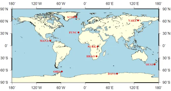
Fig. 3.1. Distribution of the selected IGS stations used for analysis ... 26
Fig. 3.2. Comparison of surface pressure and pressure derived from GPT2 for stations DAV1 (a) and OHI2 (b) ... 26
Fig. 3.3. Comparison of zenith hydrostatic delays for stations DAV1 (a) and OHI2 (b) ... 27
Fig. 3.4. RMS in U direction under 5° elevation cut-off angle (a) and 10° elevation cut-off angle (b) during 2013 ... 29
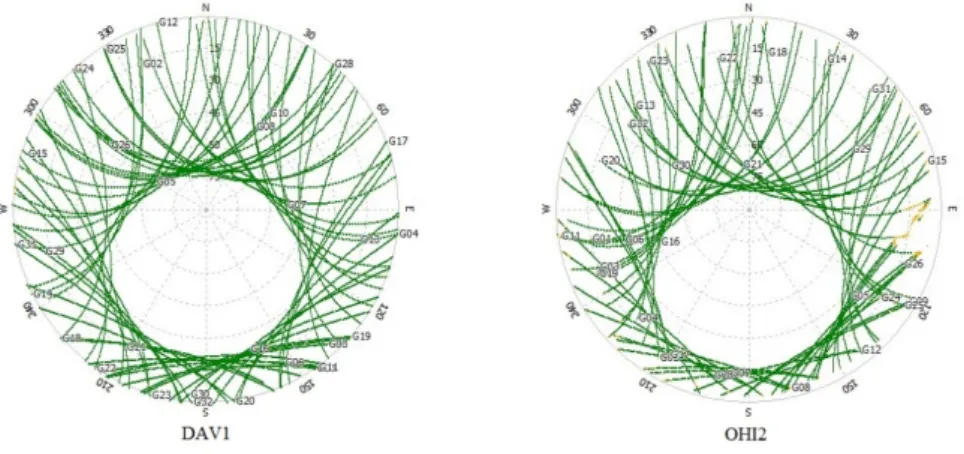
Fig. 3.5. Skyplots of the observations for Antarctic stations DAV1 and OHI2 ... 29
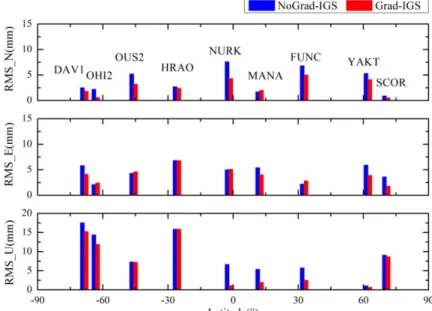
Fig. 3.7. RMS with respect to IGS results under 5° elevation cut-off angle in July 2013 ... 33
Fig. 3.6. RMS with respect to IGS results under 5° elevation cut-off angle in January 2013 ... 33
Fig. 4.1. Bias of GPS solutions with respect to IGS published results ... 44
Fig. 4.2. Bias of BDS solutions with respect to IGS published results ... 44
Fig. 4.3. Comparison of Scheme 1 and Scheme 2 ... 45
Fig. 4.4. Differences between Scheme 1 and Scheme 2 ... 46
Fig. 4.5. Bias with respect to IGS published results on day 282 ... 47
Fig. 4.6. Bias with respect to IGS published results on day 303 ... 48
Fig. 4.7. Bias with respect to IGS published results on day 304 ... 49
Fig. 5.1. Comparison of the operation time needed in the processing ... 58
Fig. 5.2. Bias of four schemes with respect to IGS published results for station CAS1 ... 59
Fig. 5.3. Bias of four schemes with respect to IGS published results for station GMSD ... 60
Fig. 5.4. Bias of four schemes with respect to IGS published results for station POHN... 60
Fig. 5.5. Bias of four schemes with respect to IGS published results for station REUN ... 61
Fig. 5.6. Bias of four schemes with respect to IGS published results for station TUVA ... 61
Fig. 5.7. Bias of four schemes with respect to IGS published results for station XMIS ... 62
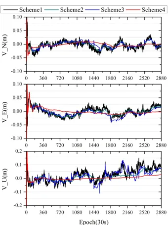
Fig. 5.8. Bias of four schemes with respect to IGS published results ... 64
Fig. 5.9. Ionosphere-free ambiguity of satellite C04 ... 67
Fig. 5.10. Ionosphere-free ambiguity of satellite C09 ... 68
Fig. 5.11. Ionosphere-free ambiguity of satellite C11 ... 68
Fig. 5.12. Bias with respect to IGS published results ... 69
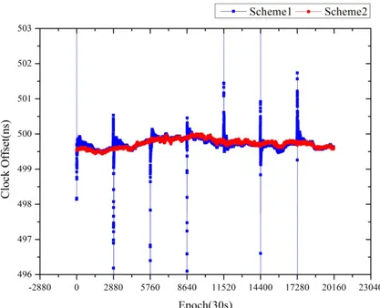
Fig. 5.13. Comparison of the convergence time of two schemes on day 265 ... 71
Fig. 5.14. Comparison of the convergence time of two schemes on day 266 ... 72
Fig. 6.1. Bias of two schemes with respect to IGS published results ... 84 Fig. 6.2. Bias of two schemes with respect to IGS published results ... 88
List of Tables xiii
List of Tables
Table 2.1 Mean and STD of the coordinates difference (units: cm) ... 19
Table 3.1 Statistics of zenith hydrostatic delay difference (units: mm) ... 27
Table 3.2 Observation models and data processing strategies for PPP ... 28
Table 3.3 RMS with respect to IGS results during 2013 (units: mm)... 29
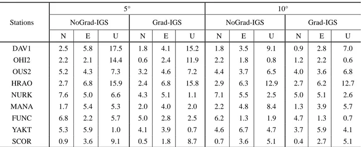
Table 3.4 Mean and RMS of difference between position results with and without horizontal gradients in January 2013 (units: mm)... 31
Table 3.5 Mean and RMS of difference between position results with and without horizontal gradients in July 2013 (units: mm) ... 32
Table 3.6 RMS with respect to IGS results in January 2013 (units: mm) ... 32
Table 3.7 RMS with respect to IGS results in July 2013 (units: mm) ... 32
Table 4.1 Observation models and data processing strategies for PPP ... 43
Table 4.2 RMS of GPS and BDS solutions with respect to IGS results (units: m) ... 43
Table 4.3 Convergence time of all four schemes ... 43
Table 4.4 RMS with respect to IGS results (units: mm) ... 47
Table 5.1 Observation models and data processing strategies for PPP ... 58
Table 5.2 RMS with respect to IGS results (units: m) ... 62
Table 5.3 RMS with respect to IGS results (units: m) ... 64
Table 5.4 RMS comparison of two schemes (units: cm) ... 69
Table 5.5 RMS comparison of two schemes (units: cm) ... 71
Table 6.1 RMS with respect to IGS results (units: m) ... 83
Table 6.2 RMS with respect to IGS results (units: m) ... 83
Table 6.3 RMS with respect to IGS results (units: m) ... 87
Research Background and Motivation 1
1 Introduction
1.1 Research Background and Motivation
Global Navigation Satellite System (GNSS) refers to a constellation of satellites providing signals from space transmitting positioning and timing data. It is playing a significant role in offering high-precision navigation, positioning and timing service for global users (Hoffmann-Wellenhof et al., 2008; Someswar et al., 2013). Positioning by means of GNSS is one of the most widely used techniques in geodetic and geodynamics applications (Gandolfi et al., 2015). In the last decade Precise Point Positioning (PPP) has become a powerful technique for determining a point’s coordinates using GNSS (Kouba and Héroux, 2001;
Zumberge et al., 1997) and it also has become increasingly significant in high-precision positioning applications. With PPP technique, observations produced by a single receiver without the requirement of a nearby reference station are used to determine its three coordinate components, along with other parameters such as the receiver clock error and the tropospheric delay of observations (Leandro et al., 2010). Currently it is being strongly considered as a solution wherever precise positioning and navigation are required in isolated locations or wide areas, where reference station infrastructure is not available (Bisnath and Gao, 2009). During recent years PPP has been widely applied in many spots, such as precise orbit determination of Low Earth Orbiters (Bisnath and Langley, 2002), marine applications (Bisnath et al., 2003; Geng et al., 2010), airborne mapping (Gao et al., 2005), atmosphere remote sensing (Gao et al., 2004), land surveying (Dixon, 2006), precise time-transfer (Defraigne et al., 2007; Defraigne et al., 2008), ionospheric (Leandro et al., 2007) and tropospheric characterization (Kjørsvik et al., 2006), biases calibration (Leandro et al., 2010), etc. During the past few years, PPP has achieved performance levels comparable to those obtainable through differencing approach (Bisnath and Gao, 2009; Griffiths and Ray, 2009), especially for GNSS permanent stations. By using the precise orbit and clock products generated by the International GNSS Service (IGS) through a dense global network and several contributing analysis centers (Dow et al., 2009), static absolute positioning can achieve an accuracy of mm-cm in post processing and a cm-dm precision level can be attained in kinematic applications (Hesselbarth, 2011;
Kouba and Héroux, 2001; Wang, 2014). For real-time application, with the availability of the IGS real-time service (RTS), it becomes possible for the users to obtain precise satellite orbit and satellite clock corrections via RTCM streams in real-time. Recent research has shown that the availability of GPS IGS RTS products is at least 95%, which makes it possible to perform real-time PPP with high accuracy (Caissy et al., 2012; Elsobeiey and Al-Harbi, 2015). Furthermore, with the rapid development of PPP technique (Bertiger et al., 2010; Grinter and Roberts, 2011; Grinter and Roberts, 2013), several PPP software packages are developed and online PPP processing services are released (Moreno Monge et al., 2013). Such online PPP services are open to users and are available 24 hours per day. Besides precise coordinates and quality information of user stations in the International Terrestrial Reference Frame (ITRF) the results also include ionospheric delays, tropospheric delays, and receiver clock corrections (Guo, 2014).
Although for many applications the PPP approach presents definite advantages regarding operational flexibility and cost-effectiveness, it requires a relatively long initialization time as phase ambiguities converge to constant values and the solution reaches its optimal precision. The convergence time of PPP will vary because it is affected by a number of factors, such as the number and geometry of visible satellites, observation quality and sampling rate, user tracking conditions, and environment (Bisnath and
Gao, 2009). Furthermore, due to the influence of pseudorange noise and tropospheric delay (etc.), the accuracy and reliability of PPP are still limited (Li, 2013). The unknown tropospheric delay parameter is usually estimated along with the position and ambiguity parameters. Ingestion of precise tropospheric models could reduce the total number of unknown parameters that need to be estimated from the observation model, potentially remove the need for noise propagating linear combinations of observables, and potentially improve positioning performance (Dodd et al., 2006). In this case, the influence of tropospheric delay on PPP is studied in this thesis. Especially in the context of polar region or with low elevation cut-off angles, where the position results of the observations are more significantly affected by tropospheric delay (Ren et al., 2011; She et al., 2011; Xu et al., 2014), the actual meteorological data are used and proved to be beneficial for improving PPP precision. The effect of the tropospheric horizontal gradient correction on PPP is also analyzed and verified to have remarkable improvement on PPP under lower elevation cut-off angles and higher humidity conditions. Moreover, a priori constrained PPP algorithms are proposed and derived to improve the efficiency and precision of PPP. The a priori information concerning the geometric and physical properties of observations, which is known with a certain a priori precision, is applied in the PPP algorithms. In this thesis the a priori constraints as employed in PPP are specified according to coordinates-, receiver clock offset-, tropospheric delay- and ambiguities-constraints, respectively, and are validated to be superior both in convergence time and positioning accuracy of PPP.
During the past decades of GPS research, advantages and disadvantages of differencing and un-differenced, combined and uncombined GPS algorithms have been discussed in detail in many publications. However, the equivalence principle can now be easily explained and accepted, since the differencing and un-differenced GPS algorithms were algebraically proved to be equivalent in Xu (2002) and the equivalence of combined and uncombined algorithms were also proved in Xu (2007). As the information, including the used GPS data and model and adjustment method, are the same, the results should also be equivalent. The equivalence properties are summarized in a theorem in Xu (2007) and Xu et al. (2010) as follows. First, for any GNSS survey with definitive space-time configuration, the results obtained by using any GNSS data processing algorithms or any mixture of the algorithms are identical.
Second, the diagonal elements of the covariance matrix and the precision of the solutions are identical.
And third, suitable algorithms or mixtures of the algorithms will be specifically beneficial for special kinds of data dealings. The theorem indicates that if the data used are the same and the model is parameterized identically and regularly, then the results must be identical and the precision should be equivalent. On the basis of the equivalence principle and the equivalence property of un-differenced and differencing algorithms pointed out in Xu (2007) and Xu et al. (2010), the specific equivalence of un-differenced and time differencing PPP algorithms is proved theoretically in this thesis for the first time. Meanwhile, an alternative method to prove the equivalence between triple differences and zero-difference is proposed and derived in this thesis as a supplement to the equivalence property of the triple differences stated in Xu (2007) and Xu et al. (2010). Then as a consequence of this theoretical study, a time differencing PPP algorithm based on the equivalence principle is also derived.
As summarized in Xu et al. (2010), one of the most important inference of the equivalence principle is the diagonalization algorithm (Xu, 2003). Based on the parameter equivalent reduction principle, the equivalently eliminated normal equation can be constructed and thus the normal equation can be diagonalised. This has a great significance for sequential adjustment and Kalman filter used in real-time data processing, since the nuisance parameter from the past can be eliminated and given up to keep the updated problem as small as possible. Generally, the observation equation can be separated into two
The Main Research Contents and Overview of the Dissertation 3
diagonal parts, respectively. Each part uses the original observation vector and the original weight matrix, while the equation owns only a part of the unknown parameters. The normal equation of the original observation equation can also be separated into two parts. Only the interested unknown part is needed to be accumulated into the present normal equation to solve the problem. Therefore the nuisance parameters are eliminated during sequential data processing so that the data processing problem remains as small as possible. Applying this method, it is realistic to make an exact and effective real-time data sequential processing (Shen et al., 2008; Shen and Xu, 2007; Xu et al., 2010).
With the rapid development of multiple GNSS systems, PPP technique is also advancing forward from mainly using GPS measurements towards using multi-GNSS combinations. With newly available precise orbit and clock data for GLONASS and BDS satellites, additional GLONASS and BDS observations can be applied to augment GPS for improved positioning accuracy, reliability, and availability using PPP.
Many studies on multi-GNSS combination have been conducted during recent years (Cai and Gao, 2013;
Dach et al., 2007; Jokinen et al., 2011). Nevertheless, these studies focus mainly on validation of precision and reliability superiority of multi-GNSS combination, while the combined algorithm itself and the weight ratio of each single system in the combination are seldom involved. The traditional combined PPP algorithm directly constructs observation equations using all GNSS observables to obtain the solution.
However, with the advance of other available systems and satellites, as well as the wide utilization of high-frequency (1-50 Hz) recording receivers, the computational load of the traditional algorithm increases exponentially, while the efficiency of the algorithm decreases significantly at the same time (Huang et al., 2013). This is highly undesirable in high performance systems. Therefore, on the basis of the equivalence principle and its inference described above, a multi-GNSS combined PPP algorithm is derived in this thesis to improve the computation efficiency by decreasing the exponentially increased computation load to single linear increase. In case of GPS/BDS combination, a method which can speed up the determination of the ambiguities parameters of BDS through applying the contribution of GPS observations is proposed and analyzed. The GPS/BDS combined PPP algorithm with inter-system bias parameter is also derived.
Furthermore, the usage of estimated ISB as a priori constraint in the GPS/BDS combined PPP is proposed to improve the convergence time and positioning accuracy. In addition, in the traditional combined PPP it is difficult to adaptively adjust the contribution of each single system to the combination through constructing total calculation, which will lead to the deterioration in the combination accuracy. In this context, the adaptively combined PPP based on the equivalence principle, which can easily achieve an adaptive adjustment of the weight ratio of each system in the multi-GNSS combination is proposed and derived. Compared to combined PPP with identical weight ratio the derived algorithms can significantly improve the accuracy of combination.
1.2 The Main Research Contents and Overview of the Dissertation
This thesis mainly explores high-performance PPP algorithms and develops GNSS algorithms with application of the equivalence principle, it includes the following chapters:
First, Chapter 1 presents the background and the motivation of this thesis and specifies the contributions of this research.
In Chapter 2 commonly used adjustment and filtering algorithms in PPP are outlined. Then the equivalence principle is described and developed. The specific equivalence of un-differenced and time differencing PPP algorithms is proved theoretically. An alternative method to prove the equivalence between triple differenced and zero-difference is proposed and derived. An algorithm of time differencing PPP based on the equivalence principle is derived and a numerical example is given.
Chapter 3 explores the influence of tropospheric delay on PPP. The effects of using actual meteorological data on positioning, especially in the context of observations in the polar region or with low elevation cut-off angles, are highlighted. The influence and improvement by applying horizontal gradient correction on PPP is also studied in this chapter. Several practical and enlightening conclusions are given.
In Chapter 4 a priori constrained PPP algorithms are researched and derived. A priori information concerning geometric and physical properties of observations, which is known with a certain a priori precision, is applied in the PPP algorithms. The contribution of different a priori information constraints on different parameters to PPP solution is studied and validated. The a priori constrained PPP algorithms are specified according to coordinates-, receiver clock offset-, tropospheric delay- and ambiguities-constraints, respectively, and are validated to have great superiority in convergence time and positioning accuracy.
Moreover, the applications of different constraints under specific conditions are also discussed.
Chapter 5 proposes and derives a multi-constellation combined PPP algorithm based on the equivalence principle. The advantages of the algorithm, the computation efficiency and accuracy of the algorithm are validated through several numerical examples. Then a method which can speed up the determination of the ambiguities parameters of BDS through applying the contribution of GPS observations is proposed and analyzed in case of GPS/BDS combination. The GPS/BDS combined PPP algorithm with inter-system bias parameter is also derived. Furthermore, the usage of estimated ISB as a priori constraint in the GPS/BDS combined PPP is proposed to improve the convergence time and positioning accuracy.
In Chapter 6 the principle, developments and application of the adaptively robust filter, are summarized and introduced. Then the adaptively robust PPP of a single system based on the equivalence principle is derived. Moreover, due to the defect of the multi-GNSS combination with equal weight ratio, two kinds of adaptively multi-GNSS combined PPP algorithms based on the equivalence principle are derived, which can easily achieve an adaptive adjustment of the weight ratio of each system in the multi-GNSS combination. The posteriori covariance matrix of the shared parameters of each single system and the Helmert variance components are used to adaptively adjust the weight ratio of each system in the multi-GNSS combination, respectively. Numerical examples are conducted to validate the derived algorithms.
Finally, Chapter 7 summarizes the main results as obtained in the previous chapters, presents the final conclusions and suggests recommendations for future work.
1.3 The Main Contributions of the Dissertation
The main contributions of this thesis can be summarized as follows.
1. In this thesis it is the first time that the specific equivalence of un-differenced and time differencing PPP algorithms is proved theoretically on the basis of the equivalence principle and the equivalence property of un-differenced and differencing algorithms. Meanwhile, as a supplement to the equivalence property of the triple differences, an alternative method is proposed and derived to prove the equivalence between triple differences and zero-difference, which up to now was missing.
2. As a consequence of above conducted theoretical study, a time differencing PPP algorithm based on the equivalence principle is derived and can be used to obtain the coordinates difference and average velocity between two adjacent epochs. Such a time differencing PPP algorithm is able to provide both position and velocity results from the phase and code observations and is expected to be beneficial for different types of applications, such as airborne gravimetry, earthquake monitoring, and could also be
The Main Contributions of the Dissertation 5
an efficient method to detect cycle slips in data processing.
3. The influence of tropospheric delay on PPP, especially in the context of observations in the polar region or with low elevation cut-off angles, where the position results of observations are more significantly affected by tropospheric delay, is analyzed and a methodology for minimizing its effect is proposed. Due to the specificity of Antarctic positioning, the actual meteorological data are used and proved to be beneficial for improving PPP precision in the Antarctic region. The effect of tropospheric horizontal gradient correction on PPP is also analyzed and verified to remarkably improve PPP precision under lower elevation cut-off angles and higher humidity conditions.
4. A priori constrained PPP algorithms are proposed and derived in this thesis to improve the efficiency and precision of PPP. The a priori information concerning the geometric and physical properties of observations, which is known with a certain a priori precision, is applied in the PPP algorithms. The contribution of different a priori information constraints on different parameters to PPP solution is analyzed and validated. The a priori constrained PPP algorithms are specified according to coordinates-, receiver clock offset-, tropospheric delay- and ambiguities-constraints, respectively, and not only the efficiency and accuracy improvement by applying constraints but also their applications under specific conditions are discussed and validated.
5. A multi-GNSS combined PPP algorithm based on the equivalence principle is proposed and derived in this thesis. With such an algorithm, the exponentially increased computational load of the traditional multi-GNSS PPP algorithm can be reduced to the single linear increase when more GNSS satellites are available and used for combined computation. In case of GPS/BDS combination, a method which can speed up the determination of the ambiguities parameters of BDS through applying the contribution of GPS observations is proposed to significantly reduce the convergence time in BDS PPP. The GPS/BDS combined PPP algorithm with inter-system bias parameter is also derived. Using the estimated ISB as a priori constraint in the GPS/BDS combined PPP is proposed. The result demonstrates that the a priori constraint of ISB shows superiority in the convergence time of PPP processing and can mainly improve the positioning accuracy in E component.
6. In traditional combined PPP it is difficult to adaptively adjust the contribution of each single system to the combination through constructing total calculation, and it will lead to the deterioration in the combination accuracy. In this context, the adaptively combined PPP algorithms based on the equivalence principle are proposed and derived, which can easily achieve an adaptive adjustment of weight ratio of each system in multi-GNSS combination. By using the posteriori covariance matrix of the shared parameters of each single system and the Helmert variance components to adaptively adjust the weight ratio of each system, the derived algorithms can improve the accuracy of combination significantly, compared to combined PPP with identical weight ratio.
Introduction 7
2 Equivalence Principle of Precise Point Positioning
2.1 Introduction
Commonly used adjustment and filtering algorithms in Precise Point Positioning (PPP) are outlined in this chapter. Adjustment algorithms discussed here include the least squares adjustment and the sequential least squares adjustment. The filtering algorithm discussed here is the classic Kalman filter. The equivalence principle is described and developed. On the basis of the equivalence principle and the equivalence property of un-differenced and differencing algorithms, the specific equivalence of un-differenced and time differencing PPP algorithms is proved theoretically. Meanwhile, as a supplement to the equivalence property of the triple differences, an alternative method is proposed and derived to prove the equivalence between triple differences and zero-difference which up to now was missing. As a consequence of the conducted theoretical study, an algorithm of time differencing PPP based on the equivalence principle is derived and a numerical example is given. Such a time differencing PPP algorithm is able to provide both position and velocity results from the phase and code observations.
2.2 Commonly Used Adjustment and Filtering Algorithms in PPP
In PPP, precise ephemeris and precise satellite clock errors are usually immediately substituted into the observation equation to fix the satellite orbits and remove the satellite clock errors. Furthermore, the first-order effects of ionospheric delay is eliminated via dual-frequency observations. Therefore the calculation model of PPP can be written as (Ye et al., 2008; Zumberge et al., 1997)
vΦ = + ⋅ ∆ + + ⋅ − ⋅ Φ +ρ c t δ λ N λ εΦ (2.1) where ρ is the geometric distance between the satellite at the emission time and the receiver antenna at the reception time; c denotes the speed of light; ∆t denotes the receiver clock error; δ denotes the tropospheric delay; λ denotes the wavelength; Φ is the ionosphere-free combined observation; N denotes its ambiguity; εΦ denotes the not modeled remaining errors like multipath and observation noise;
and vΦ is the corresponding observation error.
To solve the unknowns, like coordinates, clock error, and tropospheric delay parameters the commonly used adjustment and filtering algorithms in PPP are outlined in the next sections.
2.2.1 Least Squares Adjustment
The principle of least squares adjustment can be summarized as follows (Leick et al., 2015; Xu, 2007).
The system of the linearized error equation of Eq. (2.1) can be represented as ,
V =AX −L P (2.2)
where L is the observational vector of dimension n; A is the coefficient matrix of dimension n m× ; X is the unknown parameter vector of dimension m; V is the residual vector of dimension n; m is the number of unknown parameters; n is the number of observations; P is the symmetric and definite weight matrix of dimension n n× .
The least squares principle for solving the error equation is well-known as
T min
V PV = (2.3)
where VT is the transpose of vector V.
Solving the minimum value of V PVT with respect to X and take Eq. (2.2) into account, one has
T 0
A PV = (2.4)
where AT is the transpose matrix of A.
Substituting Eq. (2.2) into Eq. (2.4), one has
T T 0
A PAX −A PL= (2.5)
Therefore, the least squares solution of Eq. (2.2) is
( T ) 1 T
X = A PA− A PL (2.6)
where superscript -1 is an inverse operator. Denoting M =A PAT , QX =(A PAT )−1, where M is usually called normal matrix and QX is the cofactor matrix.
The covariance matrix ∑X of the estimated parameter X is
2 0
X QXσ
∑ = (2.7)
where σ0 is the standard deviation, which can be computed by
0 ( )
V PVT
n m n m
σ = >
− (2.8)
2.2.2 Sequential Least Squares Adjustment
Suppose Li is an observational vector of dimension ni at epoch i, and the corresponding weight matrix is Pi. At epoch i-1, the estimation value of the unknown parameters and its weight matrix are obtained and denoted as Xi−1 and PXi−1. The error equation at epoch i can be represented as
i i i i , i
V =A X −L P (2.9)
where subscript i denotes epoch i; A i is the coefficient matrix of dimension ni×m; Vi is the residual vector of dimension ni; m is the number of unknown parameters; ni is the number of observations at epoch i. Since the unknown parameter Xi has the a priori expectation and variance, the least squares principle of the parameter estimation is (Yang, 2006)
Commonly Used Adjustment and Filtering Algorithms in PPP 9
1 1 1
( ) ( ) min
i
T T
i i i i i X i i
V PV + X −X− P − X −X − = (2.10)
Solving the minimum value of Eq. (2.10) with respect to
X
i and taking Eq. (2.9) into account, one has1( 1) 0
i T
i i i X i i
A PV P X X
− −
+ − = (2.11)
Substituting Eq. (2.9) into Eq. (2.11), one has
1 1 1
( ) ( ) 0
i i
T T
i i i X i i i i X i
A P A P X A P L P X
− − −
+ − + = (2.12)
Therefore, the sequential least squares solution of Eq. (2.9) is
1 1
1
( ) ( 1)
i i
T T
i i i i X i i i X i
X = A P A +P − − A P L +P −X− (2.13) Denoting
1
i i
T
X i i i X
P =A P A +P − (2.14)
one has
1 1
( 1)
i i
T
i X i i i X i
X =P− A P L +P − X− (2.15)
1
1 1
( )
i i i
T
X X i i i X
Q =P− = A P A +P − − (2.16)
Eq. (2.15) is the recurrence formula of the sequential least squares solution, that
1
2 1
1
1
1 1 1
1
2 2 2 2 1
1
1
( )
( )
i i
T X
T
X X
T
i X i i i X i
X P A L
X P A P L P X
X P A P L P − X
−
−
−
−
=
= +
= +
(2.17)
1
2 1
1
1 1 1 2 2 2
i i
T X
T
X X
T
X X i i i
P A P A
P P A P A
P P − A P A
=
= +
= +
(2.18)
The posteriori covariance matrix ∑Xi of Xi is
2 1 2
0 0
i i i i i
X QXσ PX−σ
∑ = = (2.19)
where 0
σ i is the standard deviation, which can be computed by (Yang, 2006)
1 1 1
0
( ) ( )
i i
T T
i i i i i X i i
i
V PV X X P X X
σ = + − n− − − − (2.20)
where ni is the number of observations at epoch i.
2.2.3 Kalman Filter
The Kalman filter is known to estimate the state vector based on a sequence of observations and its state equation. The principle of the classic Kalman filter is outlined as follows (Brown and Hwang, 1992; Gelb, 1986; Koch and Yang, 1998; Schwarz et al., 1989; Xu, 2007; Yang, 2006).
The observation equation and the state equation can be expressed as
i i i i , i
V =A X −L P (2.21)
, 1 1
i i i i i
X = Φ − X− +W (2.22)
where subscript i and i-1 denote epoch time; Xi−1 and Xi are the simplified state vectors of dimension m at epoch i-1 and epoch i, respectively; Φi i−, 1 is the state transition matrix of dimension m m× ; Wi is the residual vector of the system state model of dimension m with zero expectation and covariance matrix
Wi
∑ ; Li is the observational vector of dimension ni; A i is the coefficient matrix of dimension ni×m;
Vi is the residual vector of observational vector of dimension ni; m is the number of unknown parameters;
ni is the number of observations at epoch i; Pi is the weight matrix of observational vector of dimension
i i
n ×n .
According to Eq. (2.22), the predicted value of the state vector Xi at epoch i can be obtained through the estimated state vector Xi−1 and the transition matrix as
, 1 1
i i i i
X = Φ − X− (2.23)
The covariance matrix
Xi
∑ of the predicted state vector Xi can be obtained by using the covariance propagation law as
, 1 i1 , 1 i
i
T
i i X i i W
X − − −
∑ = Φ ∑ Φ + ∑ (2.24)
The residual vector
Xi
V of the predicted state vector Xi is
i i i
VX =X −X (2.25)
Therefore a least squares principle of the parameter estimation is formed as min
i i i
T T
i i i X X X
V PV +V P V = (2.26)
where Pi= ∑i−1 is the weight matrix of Li and 1
i i
X X
P = ∑− is the weight matrix of Xi.
Commonly Used Adjustment and Filtering Algorithms in PPP 11
Making the partial differentiation of Eq. (2.26) with respect to Xi equals zero, one has
i i 0
T
i i i X X
A PV +P V = (2.27)
Substituting Eq. (2.21) and (2.25) into Eq. (2.27), one has
( ) ( ) 0
i i
T T
i i i X i i i i X i
A P A +P X − A P L +P X = (2.28) Therefore, the least squares solution of state vector Xi is
( ) (1 )
i i
T T
i i i i X i i i X i
X = A P A +P − A P L +P X (2.29) The covariance matrix of Xi is
1 2
( ) 0
i i
T
X A P Ai i i PX −σ
∑ = + (2.30)
Denoting
i i
T
X i i i X
P =A P A +P (2.31)
one has
1 2
i i 0
X PX−σ
∑ = (2.32)
According to the principle of the matrix identity transformation (Yang et al., 2001), that
( )
i i i i i i
X =X +K L −A X (2.33)
where Ki is called the gain matrix of the Kalman filter and is formed as
( ) 1
i i
T T
i X i i X i i
K = ∑ A A∑ A + ∑ − (2.34)
or in accordance with the matrix identity equation
( ) 1
i
T T
i i i i X i i
K = A P A +P − A P (2.35)
The covariance matrix of Xi can be obtained by using the covariance propagation law to Eq. (2.33) as
( ) 1
i i i i i
T T
X X X Ai Ai X Ai i − Ai X
∑ = ∑ −∑ ∑ + ∑ ∑ (2.36)
or
( )
i i
X I K Ai i X
∑ = − ∑ (2.37)
where I is the identity matrix.
The main difference between Kalman Filter and Sequential Least Squares Adjustment is that Kalman