Wochenbericht L19_11; 09.09. bis 12.09.2019
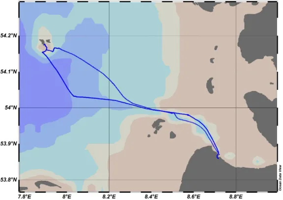
Littorina cruise L19-11 was the third Sternfahrt test campaign and sailed from Cuxhaven to Helgoland in the framework of the Modular Observation Solutions for Earth Systems (MOSES) project. The aim of the cruise was to collect oceanographic and atmospheric data along the chosen track (Figure 1) in coordination with joint campaigns of other Helmholtz Association Institutes, AWI, HZG and UFZ. The expedition took place in the southern North Sea area where the influence of outflow plume of the Elbe River is strong. The coordination and communication between three participating research vessels Littorina (GEOMAR), Uthörn (AWI) and Ludwig Prandtl (HZG) all equipped with scientific instrumentations was tested in terms of real-time data acquisition. For this purpose, TeamViewer was used, b the limited internet access did not allow successful communication between ships during transect.
Figure 1. The L19-11 cruise track from and to Cuxhaven and Helgoland.
Table 1. On board equipment list of the L19-11 cruise.
Sensor ID Parameter measured Application
(profile/underway)
Sampling frequency 1 YSI EXO1 Pressure, Salinity, Temperature,
Oxygen, Turbidity, fDOM
Underway 1 sec
2 SeaBird SeapHOx Pressure, Salinity, Temperature, Oxygen
Underway 1 sec
3 ProOceanus Methane
Water-soluble methane Underway 1 sec
4 TriOS OPUS Nitrate Underway 1 sec
5 Contros HydroC Water-soluble carbon dioxide Underway 1 sec 6 PyroScience
Optode
pH Underway 1 sec
7 Sunburst SAMI pH Underway 15 min
8 Lab-on-a-chip Nitrate Underway 20 min
9 CTD rosette Pressure, Salinity, Temperature, Oxygen, pH, chlorophyll a
Vertical profile 1 sec 10 FerryBox Salinity, Temperature, Oxygen,
pH, Turbidity, chlorophyll a
Underway 1 sec
11 Los Gatos Water-soluble and atmospheric methane
Underway Continuous 12 Picarro Atmospheric methane and
carbon dioxide
Underway 1 sec
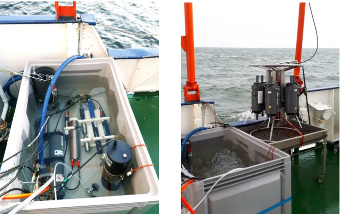
After departure from Kiel, our first activity was setting up and connecting the sensors, arranging the underway water supply to the water tank on deck throughout the Kiel Kanal. A suite of sensors (Table 1) were deployed in a water tank and connected to the underway water supply to measure water physical and chemical properties continuously (Figure 2). To measure same hydrological parameters (such as temperature, salinity, nitrate, methane) by using different sensors allowed valuable intercomparison results between these sensors. Atmospheric carbon dioxide and methane measurements was done using the Picarro analyzer. We started recording sensor data after leaving the Kiel Kanal. The sensors were operating at pre-defined sampling intervals. The flow rate of the underway water supply (100 liters/minute) allowed rapid change of water in the tank with a depth of 3m. Additional discrete water samples was collected from the Niskin bottles of CTD vertical profiler at four stations (Table 2, profile), as well as hourly from the water tank that sensors were deployed in (Figure 2, underway).
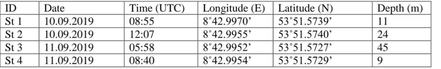
Table 2. The station list of the CTD vertical profiler.
ID Date Time (UTC) Longitude (E) Latitude (N) Depth (m) St 1 10.09.2019 08:55 8˚42.9970’ 53˚51.5739’ 11
St 2 10.09.2019 12:07 8˚42.9955’ 53˚51.5740’ 24
St 3 11.09.2019 05:58 8˚42.9952’ 53˚51.5727’ 45
St 4 11.09.2019 08:40 8˚42.9954’ 53˚51.5729’ 9
Figure 2. The water tank used for sensor deployments (on the left side) and the Niskin bottles of CTD vertical profiler (on the right side) (photo credit: M. Nehir)
We greatly appreciate the professionalism of Captain and crew of R/V Littorina who made this work a success.
L19-11 Cruise Participants:
Name Affiliation Main task/responsible for:
1 Mario Esposito GEOMAR PI
2 Münevver Nehir GEOMAR Sensors/ Water sampling 3 Mahmoud Altahan GEOMAR Sensors/ Water sampling
4 Sipan Issa AWI Los Gatos Sensor/ Water sampling