Research Collection
Conference Paper
A Knowledge-based Thematic Mapping System – the Other Way Round
Author(s):
Hutzler, Ernst; Spiess, Ernst Publication Date:
1993
Permanent Link:
https://doi.org/10.3929/ethz-a-010571024
Rights / License:
In Copyright - Non-Commercial Use Permitted
This page was generated automatically upon download from the ETH Zurich Research Collection. For more information please consult the Terms of use.
ETH Library
Published in: Proceedings of the 16th International Congress on Cartography, Cologne, 1993. 8 p., 4 fig.;
postscript
A Knowledge-based Thematic Mapping System – the Other Way Round by Ernst Hutzler und Ernst Spiess
Abstract
The development of knowledge based systems in various fields has nourished hopes that they may also be an answer to the wide range of design problems in thematic cartography. When the data are fed in and the user requirements formulated, the system guided by the rule-base performs all necessary steps without any further intervention. Such a procedure would be in full contrast to the interactive design mode, that progresses under full control of an experienced operator with cartographic skill. Being aware of the complexity of the problems, some guidance and support by rules is certainly welcome. Rules may also be helpful, where steps of the same kind are often repeated. Instead of striving for a huge expert system that offers global solutions, but seems unrealistic, because thematic maps in their great variety are much too complex for this purpose, the strategy presented in this paper is to gradually develop expert modules, in parallel to the interactive modes. The design structure of a few components of an prototype is explained and illustrated.
Expert systems for thematic cartography; description and discussion
Expert systems and artificial intelligence are the keywords in nowadays research. Researchers feel that such systems ought to play also an essential role in changing the excessively (?) intuitive character of map design towards more objectiveness and generally accepted expertise.
PUPPE (1991) in [1] elaborated that an expert system is supposed
• to understand the problem, (what means in cartography, to analyse which of the data are essential, what kind of regional distribution is most striking or revealing to the map users etc.)
• to solve the problem, (what is in cartography to find the best construction and graphic representati- on etc.)
• to explain the given solution, (that is to explain the representation laws or the parameters applied, eventually also to interprete the distribution found)
• to survey neighbouring areas, (concepts in planning, in geography, demography, politics and econo- mics)
• to assess its own competence in problem solving, (discover lacunes in the framework of graphic rules and laws, estimate the amount of ambiguity in the decisions made etc.)
• to acquire further knowledge and structure it, (in cartography e.g. by automatically testing the con- structed maps on image density, overlaping or hidden symbols, but also by incorporating the results of human evaluation of the maps produced in the system).
It is generally accepted that the greatest difficulties must be expected in the very beginning of the process, when the system tries to understand the problem, i.e. in the case of mapping to select the most relevant data for display and to make decisions on their representation in map form. Experiences in areas other than map- ping indicate that changing the rules for the moment being works only on feedback from users but not within the system itself.
So far, however, there is few evidence of operational expert systems in cartography. Intentions and ideas for initial work have been reported here and there. We may quote e.g. the model described by Bollmann (1989) in [2] for an automatized design of thematic maps, whereby the source data are analysed and evaluated, at- tributed by design and construction rules and transfered into a digital map model, which has to be tested (by another set of rules) for visual defects and corrected for final modelling. Every correction made is registered and those that are found by the system to be significant on a longer-term basis are used to change design and construction rules. This system is described as an example of a self-regulating optimization of the map design process. Other researchers might call the properties of such a system artificial intelligence.
For an experienced map designer it is hardly imaginable, that all what he undertakes in checking, in individual and global assessments and in carefully weightened decisions during a map design process may be equally se- riously performed by such a program system, the complex it may be. A recipe that works fine in one case fails in the next one. Almost every new constellation of space and data claims for an individual, often even unique solution The ability of the graphically educated map editors to unravel and clear densly woven image confi- gurations, so that they may become legible and understandable for the map user, can be reproduced by an expert system only with absolutely excessive efforts. We have to consider also the fact (Keates, 1982) [3], that the combination of map contents and representation methods creates an infinite variety of solutions, whose effects on the user side can not be anticipated with certainty, a statement that makes it extremly difficult to provide the system with an adequate decision making processor.
Advantages of expert systems in cartographic design and production are expected much more in widespread decision networks, were one tends to loose track of consequences. The program in this case can make use of an abundance of rules, can organize them accordingly and is structured to influence decisions in the direction of the optimal solution. The solution is no longer the result of a sequence of individual decisions, but is based on a space of interrelated decisions and constraints.
But again on the other hand the field of thematic mapping is extremely wide. Furthermore we are confron- ted with a large variety in requirements of various user-groups. Often solutions may be completely different with scarcely any connections in between. In view of this two-directional complexity a global solution with a comprehensive expert system for the design of all kinds of thematic maps is virtually impossible to realize. A realistic approach will have to concentrate on some restricted and individual application oriented branches.
Questionable as well is the proposed automated feedback to the knowledge-base derived from a graphic result. A generalization process e.g. may create a certain graphic constellation, which is subject to the final as- sessment. Such measures are irreversible and there are no means to reconstruct from this observation a higher order concept that will guide future processes.
Knowledge-based systems; description and discussion
An intermediate solution in developing expert systems are knowledge-based systems. They bring problems in a closed process to a final solution, starting from user requirements and source data, monitoring decisions on the basis of a large amount of expert knowledge that has been incorporated in the system. They are less pretentious than expert systems in so far as they operate within the existing knowledge and work straight on towards a solution. They do not care for external information, for self-critisism and for self-modification of their knowledge. On the other side they compete with primarily interactive procedures, whereby the operator initiates and monitors every single step.
If we accept that in cartography conceptual and graphical decisions are based not only on intuition, but are made according to solid and scientifically based rules, the conclusion is evident, that for a significant number
of these rules that guide the editing process, algorithms can be developed. This so-called expert knowledge is one of the essential components of knowledge-based cartographic systems.
Initially the enthousiasm about such future systems will certainly be great with all those map makers that lack experience in design. This may seem to them a unique opportunity to obtain results that obviously compete with those of top experts, as the latter after all have fed the system with their entire knowledge. All what the operator would have to do, is to load a complete and consistent data set and answer a few questions. Provi- ded the system has enough expertise and is well conceived, he will get a good result out of it, a solution that is conform to the initial requirements and to the given random conditions. As he has no notion of the large variety of possible solutions, he may be entirely satified at the beginning with what he has got. But how can one avoid that he will develop more and more a lack of interest in these sets of uniform maps, having no real chance to intervene, once the process is started, and not knowing what conditions the specific result?
Comprehensive automated rule-based systems versus intuition and interaction For practical applications one can choose among two concepts:
With future comprehensive knowledge-based systems, one could produce on the basis of requirements, de- duced from the mapping purpose, automatically an optimized map, when the system has been fed with a huge amount of expert knowledge about construction and graphic rules, that is periodically subjected to amendments.
The alternative is to apply for map design and production an interactive system, provided with a user-friedly surface, predefined forms, that make use of some basic rules, and offer besides certain default values for pa- rameters and a large amount of variability. In this case a graphically well-trained cartographer is needed with all his skills and defects. No doubt, within certain limits rules may be very useful. They prevent people from producing absolutely useless maps. Also, the operator can be released from repetive and similar decisions and gross errors are avoided. But whether all these decisions could be left to a sophisticated controlling system, is an open question. May we quote in this context Imhof (1968), who stated in [4] that to gain control over the graphic texture of intricate maps, demands human decisions on practically every square centimetre!
We have the impression that on a long-term basis this alternative concept will prove to be more fruitful. We should make use of the cartographer’s specific abilities, of his sound self-critisism, his socio-cultural integra- tion, his sensivity for continuing changes, his adaptability, his originality and imperfection, in order to keep cartography attractive and vital.
Description of an open-ended knowledge-based system with expert modules
In conclusion of the above considerations we are in favour of open-ended, operator-controlled systems with embeded rule-based and object-oriented modules, whereby step by step commented variants are presented for selection. Based on former experiences default values may be set for the parameters. The various proposals can be presented in form of legend specimens as well as alphanumeric lists of parameters. The system will react with a message or warning if initial requirements or graphic rules are violated, but leaving it to the ope- rator, if he wishes to continue nevertheless. The whole production line has to be fragmented into a number of construction or modelling steps, each of them allowing to intervene and react on the interim result.
The production process for thematic maps with such systems may be described by fig.1. When the map topic has been given or chosen, field surveys or statistical data, which are relevant in this context, have to be gathe- red. On the other hand base map elements must be prepared. In this initial phase the map purpose is formu-
lated in view of the anticipated questions of potential map users. Map scale, map format and region mapped depend on each other. As long as two of them are not yet fixed, we have to consider them as free parameters.
Other external considerations may influence these decisions, as e.g. expected cost or production time.
With this conception in mind the given thematic data have to be analysed, preferably in an interactive mode, that allows to visualize results and specify supplementary queries. Plausibility tests also have to be included.
Thereafter data may be structured accordingly. The base map elements as well are analysed and structured.
Which other element e.g. can be combined with the administrative boundaries? What degree of generaliza- tion must be applied in the case of a combination of the river network with such boundaries? If the expense can be justified, we see an advantage to handle these processes by rule-based expert modules. Letter „M“ in fig.1 indicates in which processes such modules seem to make sense and where they may be partly structured in frames („O“ = object-oriented).
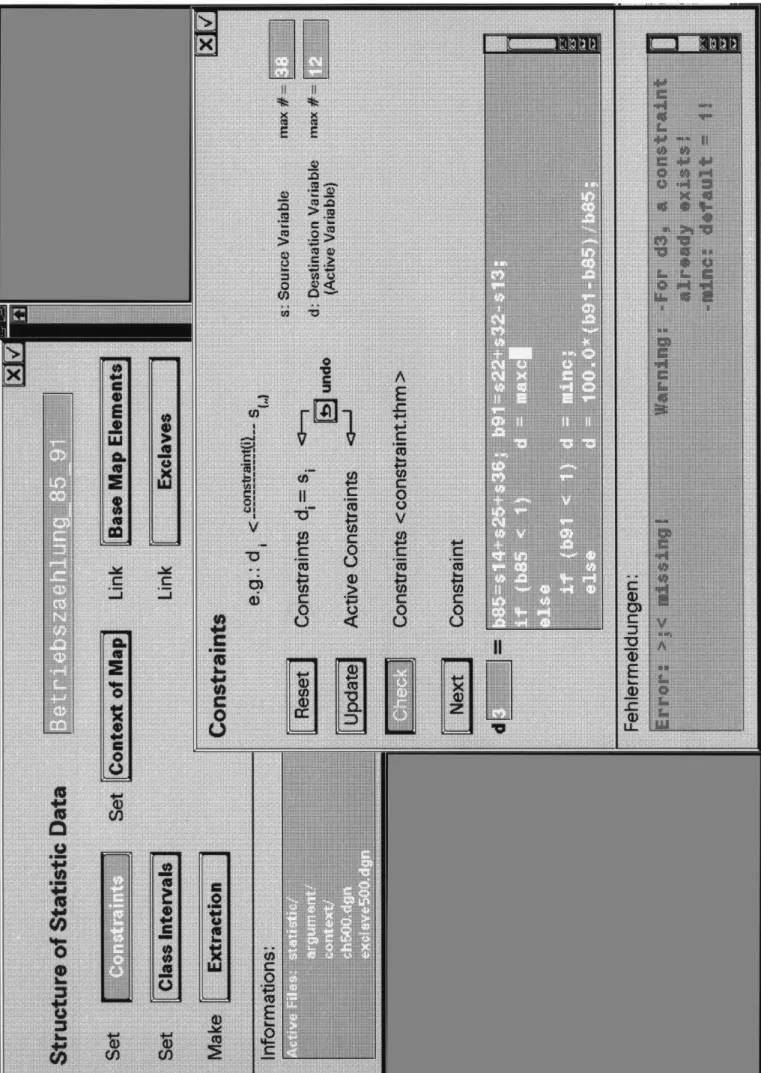
The decisions to make are preferably guided by forms (fig.5 and 6) that serve as checklists, as records of pa- rameters and constraints and for error and warning messages. The latter may include an optional help and teach function for inexperienced operators, giving advice on how to use the form in certain cases or explaining why certain constraints cannot be avoided. These features seem to be especially useful to make the semi- automated decision process more transparent and acceptable compared to the black-box of an expert system.
The procedure seems to be favorable also from an educational point of view, occasionally even for training experts!
The form «Structuring of Statistical Data» (fig.2), part of an object-oriented module, gives an idea, how a limited amount of data (12 variables) may be extracted from a larger source data set (38 variables). Value d3 will be expressed as the percentage of the increase in people employed in the period 1985-1991, based on 6 source values.
This way prepared and fed the rule-based module develops a proposal for the design of the map, chooses the best suited graphic variables and graphic construction, calculates optimal parameters and provides them with pertinent comments. The map compilation process ends with a solution in a certain map type, a complete con- struction of the whole map, to be visualized on the display in every detail and as a whole. If the cartographer is not satisfied at all, he turns into a loop to start the whole process again with slightly different parameters or with a change in the concept that may end in another map type. If the solution is somewhat satisfactory a thorough map analysis may be undertaken as a final test of the design concept before continuing into map production. This last stage includes work steps like clarifying any overlap, lettering, final specifications for co- lours, textures and line widths. Provisional specifications may have served in the design process.
Rule-based design modules
Fig.3 describes in more detail the map design part of fig.1, the general procedure to come to a map design proposal suitable for the subsequent map construction. The rule interpreter or inference machine is fed with the data analysed and structured in the preprocess and with the initial requirements. It selects pertinent rules from the catalogue of general design rules and tests all possible graphic variables against the input data. The result of the evaluation of the proposal may be to subject it to a coarse adjustment loop, a module in which the design rules may be modified. This done, in a second run a fine adjustment may be needed on the side of the data parameters. Usually it will be sufficient to look for a variant within a given tolerance without restructuring the data. In certain cases a need to go back to the input level may arise.
Fig. 2: Form for the object-oriented modul for the structuring of the statistical data
Decision making by the operator is essential. He may decide on the basis of a first proposal visualized on the display, that shows the proposed map type, with construction parameters, with a legend figure, with indi- cations on the degree of generalization and the chosen base map elements. When he finds it necessary to modify certain graphic rules, in general or for this specific map only, he will gradually improve and extend his catalogue of design rules or his descriptions of possible variants.
When the proposal is accepted, one can proceed into the map construction module. Fig.4 illustrates the con- ception of such a module for the whole group of diagram maps. Graphic variables according to the design proposal are assigned to the data and the diagram type is selected. The editor is provided also with a proposal for the map legend, which he may now modify and shift around in his layout. His expertise may allow him to extend or adapt the rules in the construction library, whenever he has developed an improved or new solution.
Inevitably one will wish to improve on the relative positioning of those diagrams that overlap, compete with
or disturb each other. In this case, however, we do not believe in an automatic feedback. The form «Complete Construction Library» (fig.5) indicates that in this diagram map with devided wing diagrams another pair of semi-circles is superimposed and appended to the diagram position. The idea is to allow also for a comparison of the total number of the left side with the one on the right side. The warning indicates that the actual de- finition creates only the outlines of the semi-circles and that no filling will be possible, what of course makes sense in this combination. This proposal is added to the construction library and will allow in future tasks to include this item in the generation of the diagram whenever the user requires also these sums.
In contrast to such construction modules (fig.6) gives an example of a comprehensive form as it is used in the interactive mode. The underlying construction program requires a full set of parameters. Most of them have been chosen already in the conceptional phase. Each time when a new variant is to be constructed, the whole set of parameters has to be reconsidered and eventually adapted. In comparison, when using the above expert module for the construction of the diagrams, only those forms with the parameters that are supposed to be changed are opened. If minor adjustments in the rules have to be made, the respective parameters in the construction library are opened and modified. In both cases extensive plausibility tests are installed in the programs.
Final remarks
The approach to design and produce thematic maps using rule-based design modules may be seen as a know- ledge-based mapping system, the other way round. With a knowledge-based system one goes the straight and fully automated way from the initial requirements and data through the black-box of rules to a final result.
No doubt that one will look forward to the result of this procedure in any case with excitement, will then be surprised, sometimes in the positive often in the negative sense, because the product may not meet the expec- tations of the operator. Too much depends on the initial conceptual input, on which the operator has scarcely enough information and therefore bad control. On the other hand an all-embracing questionnaire to start the whole process with, may be too sophisticated for the normal user.
The other way round means that the decisions in each step are based on the full knowledge of possible al- ternatives and options. On demand the rules that guide a certain choice can be listed and even explained.
A further advantage is that the user can amend the rules, based on his own judgment and experience. Map variants are not found at random but based on some analysis of possible alternatives.
The plans are to continue to realize the described modules step by step, starting to automate them in those areas where the interactive methods provide us with proven rules. In all cases the interactive path will still be offered besides the rule-based decision. The spectrum of solutions will be much wider, what has a positive impact on the general interest in these maps. Expert system advocates probably refer to similar possibilities along the way a design problem comes to its solution. We feel however that cartographers ought to play a more active role in their primary field of activity.
References:
[1] PuPPe, Frank: Einführung in Expertensysteme.- Studienreihe Informatik. Springer Verlag, Berlin, 2.Aufl. 1991, 215 S., 86 Abb.
[2] Bollmann, Jürgen: Ansätze zur Automatisierung von kartographischen Konzeptions- und
Gestaltungsprozessen.- In.Wiener Schriften zur Geographie und Kartographie, Band 2, Wien, 1989.
S.140-151.
[3] Keates, J.S.: Understanding Maps.- Longman, London, 1982. 139 p.
[4] Imhof, Eduard: Kartographische Geländedarstellung.- de Gruyter, Berlin 1965. 425.S., zahlreiche Abb.
[5] sPIess, Ernst: Bemerkungen zu wissensbasierten Systemen für die Kartographie.- In: Vermessung, Photogrammetrie, Kulturtechnik 2/90, S.75-81, 11 Abb.