Understanding modern and past sedimentary processes in selected lakes from the High Arctic and
the Mediterranean realm
Inaugural-Dissertation
zur
Erlangung des Doktorgrades
der Mathematisch-Naturwissenschaftlichen Fakultät der Universität zu Köln
vorgelegt von
Dipl. Geol. Alexander Francke
aus Duisburg
Tag der mündlichen Prüfung: 14.04.2014
Abstract
Lacustrine sediment sequences can provide valuable archives of past environmental and climatological variability in terrestrial realms. In order to unravel the history of a lake and of a lake’s catchment, a profound understanding of the sedimentary processes is required. This encompasses the supply of allochthonous organic matter, nutrients and clastic material to the lake, the subsequent redistribution within the lake as well as autochthonous organic matter and mineral deposition. These lake internal and external processes are closely linked to the environmental and climatological settings in the specific area and can be reconstructed by using geophysical and sedimentary data. Within the scope of this thesis, modern and past sedimentary processes of selected lakes from the High Artic (Lake El’gygytgyn, NE Siberia) and the Mediterranean Realm (lakes Dojran and Ohrid, Balkan Peninsula) were analyzed by using various datasets and analytical methods. The obtained information about variations in the lakes’
internal and external processes were subsequently used for paleoenvironmental and -climatological reconstructions in the respective area.
At Lake El’gygytgyn, modern sedimentary processes were investigated by using geochemical, grain-size and mineralogical data from source rocks, inlet streams and surface sediments. The obtained informa- tion about modern sedimentary processes improved the understanding of hydro-acoustic and downhole logging data, as well as of variations in the granumoleric, geochemical and physical properties of core 5011-1 which covers the entire lacustrine succession of the 3.58 Ma year old Lake El’gygytgyn. Surface samples and downcore data were analyzed by using statistic methods such as Principal Component Analysis (PCA), Redundancy Analysis (RDA), Time Series Analysis and Cluster Analysis. At Lake Dojran, hydro-acoustic data and sediment properties (water content, OM, calcite (CaCO
3) content, sulfur content, grain-size, XRF scanning, δ
18O
carb, δ
13C
carb, δ
13C
org) of a 7 m long sequence were used to untangle past sedimentary processes and environmental variations during the Late Glacial and Holocene period. Sediment (lithostratigraphic description, XRF scanning, water content, OM content, calcite content) and hydro-acoustic data were also used to characterize a 2 m thick Mass Wasting Deposit (MWD) in Lake Ohrid.
As various analytical and statistical methods were used to investigate modern and past sedimentary processes in the selected lakes, an evaluation of these methods is conducted within the scope of this thesis. It could be shown that information about modern sedimentary processes derived from lacustrine surface samples and from catchment samples can help to better understand past sedimentary processes as it provides insights into spatial variations in the deposition processes. Spatial variations of past sedimentary processes and the overall sediment architecture of lacustrine deposits can be analyzed using hydro-acoustic data. However, the vertical resolution of hydro-acoustic data is limited and the data commonly lacks a robust chronology. Chronostratigraphic well constrained and high resoluted informa- tion about past sedimentary processes can be derived from sedimentary properties of a sediment core.
These properties include lithologic information such as sediment structure, grain-size, and inorganic
and organic geochemistry. These proxy data can be obtained by visual core descriptions and laboratory
analyses. However, certain proxies can commonly only be used to reconstruct a specific part of sedi-
In order to interpret sediment sequences for paleoenvironmental and -climatological variations in a
temporal context, an age model is commonly established by using for example radiocarbon ages and
chronological tie points derived from tephrostratigraphic or paleomagnetic data. Cross correlation to
well dated sediment sequences or wiggle matching to orbital parameters can improve a chronostrati-
graphic modell. However, this involves the danger of misinterpretations or loss of information about the
timing of geologic or climatic events.
Zusammenfassung
Seesedimente können als wertvolles Archiv der Klima- und Umweltgeschichte in terrestrischen Gebieten dienen. Um die Entwicklung eines Sees und dessen Einzugsgebietes anhand von lakustrinen Ablagerungen zu rekonstruieren bedarf es allerdings eines profunden Verständnisses der vorherschenden Sedimentationsprozesse. Diese Prozesse umfassen nicht nur den allochthonen Eintrag von organischem und klastischem Material und Nährstoffen, sondern auch die autochthone Ablagerung von Organik und Mineralen aus der Wassersäule. Dabei stehen diese internen und externen Prozesse im engen Zusammenhang zu den Umwelt- und Klimabedingungen in der Region und können mit Hilfe von geophysikalischen und sedimentologischen Methoden rekonstruiert werden. Im Rahmen dieser Arbeit wurden die Sedimentationsprozesse in ausgewählten Seen aus der Arktis (El’gygytgynsee, NO Sibirien) und dem Mittelmeerraum (Dojran- und Ohridsee, Balkanhalbinsel) mit Hilfe von verschiedenen Datensätzen und Methoden analysiert. Die gewonnenen Daten über Veränderungen der externen und internen Prozesse wurden anschließend zur Umwelt- und Klimarekonstruktion genutzt.
Am El’gygytgynsee wurden zunächst die rezenten Sedimentationsprozesse anhand von geochemischen, mineralogischen und granumolerischen Daten von anstehendem Gestein im Einzugsgebiet, sowie von Sedimentproben aus Zuflüssen und Oberflächenproben der lakustrinen Ablagerungen analysiert.
Die gewonnenen Daten konnten anschließend für ein besseres Verständnis von hydroakustischen und “downhole logging“ Daten sowie von Veränderungen der geochemischen, physikalischen und granumolerischen Zusammensetzung des Sedimentkerns 5011-1 aus dem 3.58 Millionen Jahre alten El’gygytgynsee genutzt werden. Die Auswertung der Oberflächenproben und Sedimentkerndaten erfolgte dabei mit Hilfe der statistischen Methoden der Hauptkomponentenanalyse (HKA), Redun- danzanalyse (RDA), Zeitreihenanalyse und Clusteranalyse. Am Dojransee konnte die spätglaziale und holozäne Klima- und Umweltgeschichte anhand hydroakustischer Daten und den Sedimenteigen- schaften (Wasser-, Kalzit-, Schwefel- und Organikgehalt, Korngröße, XRF-Daten, δ
18O
carb, δ
13C
carb, δ
13C
org) eines 7 m langen Kernes rekonstruiert werden. Ebenso wurde anhand von sedimentologischen (Lithostratigraphie, XRF- Daten, Wasser-, Kalzit- und Organikgehalt) und hydroakustischen Daten ein 2 m mächtiger Rutschungskörper im Ohridsee untersucht.
Im Rahmen der an den ausgewählten Seen durchgeführten Untersuchungen zur Rekonstruktion von
rezenten und vergangenen Sedimentationsprozessen wurden verschiedene analytische und statistische
Auswertmethoden angewandt, die im Anschluß evaluiert und bewertet wurden. Es konnte gezeigt
werden, dass Untersuchungen über rezente Sedimentationsprozesse anhand von lakustrinen Ober-
flächenproben sowie von Gesteins- und Sedimentproben aus dem Einzugsgebiet wichtige Informationen
über räumliche Unterschiede der Ablagerungsbedingungen liefern können, was zum besseren Verständ-
nis bei der Rekonstruktion der Sedimentationsgeschichte beitragen kann. Informationen über räumliche
Veränderungen bei den Sedimentationsprozessen in der Vergangenheit, sowie über Sedimentstrukturen
in lakustrinen Becken können auch anhand von hydroakustischen Daten gewonnen werden. Allerdings
ist die vertikale Auflösung von hydroakustischen Daten begrenzt und eine genaue chronologische
Einordnung ist oftmals nicht möglich. Hochauflösende und chronostratigraphisch eingrenzbare In-
ein Teil der Sedimentationsprozesse rekonstruiert werden kann, in diesem Falle die Strömungsenergie während der Ablagerung, sollten zur Erstellung eines Gesamtbildes der vorherschenden Prozesse mehrere Datensätze kombiniert werden. Dabei kann, wenn der gewählte Datensatz sehr umfangreich wird, die Anwendung von statistischen Methoden wie zum Beispiel der HKA, RDA, Zeitreihenanalyse oder auch der Clusteranalyse, hilfreich sein. Allerdings konnte im Rahmen dieser Arbeit gezeigt werden, dass die Ergebnisse solcher statistischer Methoden im geologischen Kontext schnell falsch interpretiert werden können.
Zur Umwelt- und Klimarekonstruktion anhand von Sedimentabfolgen im zeitlichen Kontext ist es nötig ein Altersmodell zu erstellen. Solche Altersmodelle werden in der Regel anhand von Radiokarbon- datierungen sowie von chronostratigraphischen Informationen aus der Tephrostratigraphie und Paläo- magnetik erstellt. So genanntes "wiggle matching" zu Erdbahnparametern oder auch "cross correlation"
zu anderen, gut datierten Sedimentabfolgen kann die Qualität von Altersmodellen verbessern, birgt aber
auch die Gefahr von Fehlinterpretationen sowie dem Verlust von Informationen über das genaue Timing
von geologischen oder klimatischen Ereignissen.
Acknowledgment
First of all, I would like to give many thanks to my supervisor PD Dr. Bernd Wagner for giving me the opportunity to work on my Ph.D. thesis within the scope of the SCOPSCO project at the University of Cologne. He always supported me during my studies with fruitful discussions and gave me great motivation and guidance as well as the opportunity to participate on several field campaigns.
Many thanks also go to Prof. Dr. Martin Melles for giving me the opportunity to complete my studies with sample material from the “Lake El‘gygytgyn Drilling Project“ and for being my second referee.
For financial support of my thesis, of several field campaigns, and of a 3-week stay at the British Geological Survey (BGS) I would like to thank the German Research Foundation (DfG, grant no. WA 2109/11 and ME 1169/21), the German Federal Ministry of Education and Research (BMBF, grant no. 03G0642A), the International Continental Drilling Project (ICDP), and the Collaborative Research Centre (CRC) 806 “Our way to Europe“.
Many thanks also go to Dr. Laura Sadori for being my third referee and to Prof. Dr. Frank Schäbitz for taking the chair of my examination committee.
In particular Dr. Volker Wennrich is acknowledged for the great support not only during the work for the “Lake El‘gygytgyn Drilling Project“, but also for many fruitful discussions and for acting as the assessor for my defenses.
Prof. Dr. Melanie Leng (University of Leicester, BGS, Nottingham) is acknowledged for giving me the opportunity to conduct my work on stable isotopes at the British Geological Survey in Nottingham and for the support with the scientific interpretation of the data.
Furthermore, I want to express my gratitude to my various co-authors, i.e. Dr. Catalina Gebhardt, Dr.
habil. Norbert Nowaczyk, Prof. Dr. Janet Rethemeyer, and Prof. Dr. Julie Brigham-Grette.
I would like to thank my colleagues / ex- colleagues Dr. Daniela Sprenk, Dr. Anne Böhm, Dipl.-Geogr.
Nicole Mantke, Dr. Sonja Berg, Dr. Janna Just, Dr. Finn Viehberg, Dr. Hendrik Vogel, and Dipl. Geol.
Daniel Treu for their support.
I warmly thank Peter Schweinhage for editing the English of this manuscript as well as Darja Friesen and Andrea Lauss for the great support with Latex typsetting. Many thanks also go to Nadja Memmer, Raphael Gromig, and Niklas Leicher for final proof-reading.
Additionally, I would like to thank all colleagues from the Institute for Geology for a great time and experiences on both professional and personal level. In particular I would like to acknowledge Ascelina Hasberg, Daniela Sprenk, Linda Prinz, Sarah Esteban-Lopez, Marina Kemperle, Julia Diederich, Niklas Leicher, Benedikt Ritter, Raphael Gromig, Florian Boxberg, and Dominik Hofer.
Finally, I would like to thank my family and in particular my parents Irene and Jochen for the support
and encouragement they gave me in the past! A special thank goes to Kristiana Balzer for wonderful
help, support, and encouragement during my studies.
Abstract III
Zusammenfassung V
Acknowledgment VII
1 Introduction 10
1.1 Lake sediments as paleoenvironmental archive . . . . 10
1.2 Studied lakes . . . . 11
1.2.1 Lake El’gygytgyn . . . . 11
1.2.2 Lake Dojran . . . . 13
1.2.3 Lake Ohrid . . . . 14
1.3 Objectives . . . . 17
2 Modern sedimentation patterns in Lake El’gygytgyn, NE Russia, derived from surface sediment and inlet streams samples 19 3 Multivariate statistic and time series analyses of grain-size data in Quaternary sediments of Lake El’gygytgyn, NE Russia 34 4 Chronology of Lake El’gygytgyn sediments - a combined magnetostratigraphic, palaeoclimatic and orbital tuning study based on multi-parameter analyses 47 5 Petrophysical characterization of the lacustrine sediment succession drilled in Lake El’gygytgyn, Far East Russian Arctic 68 6 A Late Glacial to Holocene record of environmental change from Lake Dojran (Macedonia, Greece) 84 7 Possible earthquake trigger for 6
thcentury mass wasting deposit at Lake Ohrid (Macedonia/Albania) 103 8 Discussion - Understanding sedimentary processes 114 8.1 Surface sediment and catchment samples . . . 114
8.2 Hydro-acoustic data . . . 115
8.3 Sediment cores . . . 116
8.4 Chronostratigraphy . . . 121
8.5 Multivariate statistic methods . . . 123
9 Summary and Conclusion 124
Contents
10 References 126
11 Paper Contributions 131
12 Erklärung 132
1.1 Lake sediments as paleoenvironmental archive
The composition of lacustrine deposits is influenced by a variety of external and internal environmental factors. External influences, such as climate conditions, bedrock composition, vegetation cover, hydro- geologic conditions, and tectonic and volcanic activity predominantly affect the allochthonous sediment supply to a lake (Cohen, 2003). These external influences are highly interactive with lake internal factors such as aquatic biota, productivity, lake-internal current systems and bathymetry, all of those influencing the allochthonous and the autochthonous sedimentation (cf. Cohen, 2003). The dependency of the sediment compositions to these internal and external influences is the basis of the paleoenvironmental and paleoclimatological reconstruction using sedimentary, biogeochemical, geochemical and biological proxy data from lake sediments. Thereby, the interpretation of the lacustrine sediment archives requires a profound understanding of the sedimentary processes in the investigated lake system. Sedimentary processes can modify the recorded paleoenvironmental or paleoclimatological signal (Cohen, 2003).
For example, intensive bioturbation can filter a climatic signal in terms of temporal resolution, or strong lake-internal currents might influence the deposition of pollen, diatoms or other biologic indicators.
Moreover, event deposits, such as MWDs (mass wasting deposits), are deposited in a very short time period. Their sedimentation can commonly not be explained by climatological variations. More likely, they might be related to seismic activity or slope instability (e.g. Lindhorst et al., 2012; Sauerbrey et al., 2013).
Basic sediment properties, such as sediment structure, texture, grain-size distribution, and the amount of
clastic and organic matter (OM) can give crucial information about sedimentary processes and catchment
dynamics. Moreover, basic sediment properties can also directly be used for paleoenvironmental and
paleoclimatological interpretations. For example, the grain-size distribution is linked to transport energy
which can be interpreted in terms of lake level fluctuations, wave activity or contourite drift variations
(e.g. Magny et al., 2007; Vogel et al., 2010a; Aufgebauer et al., 2012; Wagner et al., 2012). The
amount of clastic material in the sediment could be explained by dilution with OM or variations of
erosional processes in the catchment area. However, geological or geophysical data sets such as surface
sediment samples, catchment samples, hydro-acoustic data, and sediment cores as well as analytical and
statistical methods have their own potential and limits to unravel past sedimentary processes. Thus, a
crictical evaulation of widly used methods, such as conducted within the scope of this thesis, can help to
improve the use of sedimentary proxy data for paleoenvironmental and -climatological reconstruction. If
sedimentary processes in a lake are well understood, lacustrine sediments can provide long lasting, high
resoluted and continuous archives of paleoenvironmental and -climatological variability in terrestrial
realms. Naturally, the temporal resolution depends on the sedimentation rate in the lake, and a continuous
sediment sequence can be retrieved from lakes that did not experienced any extreme low stands of lake
levels or desiccation events.
1. Introduction
Together with ice cores from Greenland or Antarctica, loess sequences and speleothem records, lake sediments are the only terrestrial earth history records that provide such a combination of duration and resolution (cf. Cohen, 2003). A distinct benefit of lacustrine deposits is that lakes are widely distributed over terrestrial realms, which enables the selection of lakes in climatic sensitive areas. In the scope of this thesis, three lakes from the High Artic (Lake El’gygytgyn) and Mediterranean Realm (Lake Dojran and Lake Ohrid) have been investigated, as both regions are known to play an important role in the global climate system. The High Arctic region balances the surplus of solar energy of the tropics (Brigham-Grette et al., 2007), and global warming is predicted to be most pronounced in high latitude areas (ACIA, 2004; Serreze and Francis, 2006). The Mediterranean Region is located at the boundary of the atmospheric Hadley and Ferrel cells and is highly sensitive to variations in the mid-latitude and tropical climate systems (Giorgi and Lionello, 2008).
1.2 Studied lakes
The following sections provide a first overview about the studied lakes as well as about previous studies and available sediment cores at the respective sites. As this thesis is based on 6 individual publica- tions, the reader is also referred to the according chapters for more detailed information about the lakes and projects. As only a brief overview about Lake Ohrid is presented in the publication of chapter 7, comprehensive information about Lake Ohrid are presented in chapter 1.2.3.
1.2.1 Lake El’gygytgyn
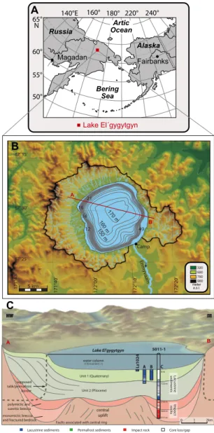
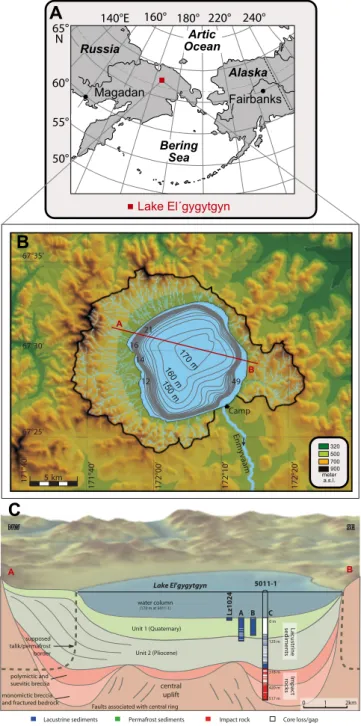
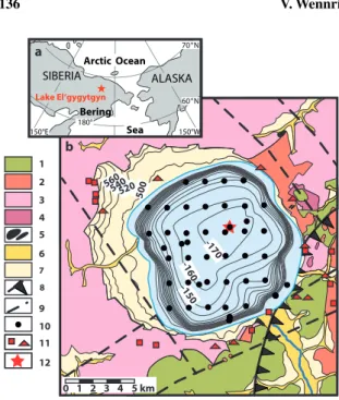
Lake El’gygytgyn is located in the central part of the Chukchi Peninsula in the Far East Russian Arctic, (67
◦30’ N, 172
◦05’ E, 492 m a.s.l. (above sea level), Fig. 1.1A). It has been formed within a meteorite impact crater (Fig. 1.1B, e.g. Dietz and McHone, 1977; Gurov et al., 1979), which was dated to about 3.58 Ma (Layer, 2000). The crater was filled with water a few thousand years after the impact (Brigham-Grette et al., 2013), and a continuous lacustrine sediment succession has been deposited until today (Melles et al., 2012; Brigham-Grette et al., 2013).
Lake El’gygytgyn is up to 175 m deep and it has a nearly circular shape with a diameter of about 12 km (Nolan and Brigham-Grette, 2007). Today, the water column is fully mixed with almost complete oxygen saturation during summer, but a thermal stratification occurs during winter (Cremer and Wagner, 2003).
The lake is oligotrophic to ultra-oligotrophic as demonstrated by a low bioproductivity (Cremer and
Wagner, 2003; Nolan and Brigham-Grette, 2007). Approximately 50 ephemeral inlet streams feed Lake
El’gygytgyn, (see also Fig. 1.1, Nolan and Brigham-Grette, 2007), and deliver sediment in the order of
about ca. 350 t/yr to the lake (Fedorov et al., 2013). The Envynman River drains the lake in southeastern
direction.
67°25’
67°30’
67°35’
171°40’ 171°40’ 172°00’ 172°10’ 172°20’
14 16
21
Enmyvaam Camp
5 km
160 m
150 m 49
320500 700900 meter a.s.l.
B
A
B 170 m
12
Faults associated with central ring 0 1 2km
Lake El'gygytgyn NW
5011-1
SE
polymictic and suevitic breccia supposed talik/permafrost border
monomictic breccia and fractured bedrock
central uplift Unit 1 (Quaternary) water column
(170 m at 5011-1)
Unit 2 (Pliocene)
318 m 123 m
420 m 0 m
517 m Lacustrinesediments Impactrocks
A B
C
A B C
Lacustrine sediments Permafrost sediments
Lz1024
Impact rock Core loss/gap
Lake El´gygytgyn 60°
55°
50°
Alaska
Bering Sea
Fairbanks Magadan
Figure 1.1: A: Location of Lake El’gygytgyn in the Far East Russian Artic,B: Bathymetric map of the lake and topographic map of the catchment area, including the approximately 50 inlet streams and the Enmyvaam River outlet. (Fedorov and Kupolov, 2005); red line: profile A to B.C: Schematic profile A to B with the locations of the pilot core Lz 1024 and the three holes (A, B and C) at ICDP site 5011-1 with the Pliocene/Pleistocene boundary penetrated at approximately 123 m, and the transition to the impact breccia at 318 m below lake floor (modified after Melles et al., 2011)
Lake El’gygytgyn is surrounded by continuous permafrost whose onset can presumably be traced back
to the Late Pliocene (Glushkova and Smirnov, 2007) and which is assumed to have a thickness of about
330-360 m with an unfrozen talik underneath the lake (Mottaghy et al., 2013). The geomorphologic
shape of the catchment area, which is confined by the almost circular crater rim measuring about
18 km in diameter, is modified by permafrost processes such as solifluction and cryogenic weathering
1. Introduction
Modern climate conditions at Lake El’gygytgyn correspond to a High Arctic climate with a mean annual air temperature of -10.4
◦C and an annual precipitation between 70 and 200 mm measured between 2002 and 2008 (Nolan et al., 2013). Strong (up to 21 m/s) and very persistent winds (mean of 5.6 m/s in 2002) of north-northwestern and south-southeastern directions are dominant (Nolan and Brigham-Grette, 2007).
The long sediment core 5011-1 retrieved from central parts of the lake within the scope of an ICDP (International Continental Drilling Project) deep drilling campaign in 2009 covers the entire lacustrine succession and the upper about 200 m of the impact related bedrock (Fig. 1.1C). The core is the first continuous Pliocene/Pleistocene sediment record in the terrestrial Artic (Melles et al., 2012). Previously, paleoenvironmental and paleoclimatic records from the High Arctic were only available from ice cores from Greenland (NGRIP-members, 2004) which are limited to the last Glacial/Interglacial cycle, or from often discontinuously or temporally restricted archives from the marine realm and Arctic borderland (Thiede et al., 1998; Backman et al., 2005; Moran et al., 2006; Axford et al., 2009; Pienitz et al., 2009;
Zech et al., 2011). Within the scope of several pre-site surveys for the deep drilling campaign, hydro- acoustic surveys were conducted and a set of lacustrine surface sampes, catchment samples, and sediment cores were recovered between 1998 and 2003.
1.2.2 Lake Dojran
Lake Dojran is located at the border of the Former Yugoslav Republic of Macedonia (FYROM) and Greece (Fig. 1.2A, 41
◦12’ N, 22
◦44’ E). It is considered to be a relict of the Plio-Pleistocene Peonic Lake, which was formed by volcanic and tectonic activities (Cvijic, 1911; Stojanov and Micevski, 1989).
B
N 45°
0 100 200km
Ionian Sea 20° E 15°
35°
A
Dojran FYROM
Aegean Sea Bulgaria Serbia
Albania
Italy Adriatic
Sea
Ohrid, Prespa
Greece
Romania Croatia
Bosnia &
Herzeg.
Turkey
1
0 2 km
FYROM
Greece N
Co1260
Figure 1.2: A: Location of Lake Dojran in the northeastern Mediterranean region at the border of the Former Yugoslav Republic of Macedonia (FYROM) and Greece. Marked are also lakes Ohrid and Prespa. B: Satellite image of Lake Dojran with the coring location Co1260 (red square) and the hydro-acoustic profiles. The black arrow indicates the position of the former outlet River Doiranitis, and the yellow line shows the border between FYROM and Greece.
presumed that lake water mixing occurs during winter, similar to Lake Prespa (Matzinger et al., 2006).
Small rivers, creeks and probably an aquifer are feeding Lake Dojran in particular during winter and spring (Griffiths et al., 2002; Sotiria and Petkovski, 2004; Manley et al., 2008), and seasonal lake-level fluctuations resulted in floodings of littoral areas in the past (Manley et al., 2008). Today, the maximum lake level is controlled by the regulation of the channelized outlet River Doiranitis (Fig. 1.2B). Water supply to Lake Dojran also includes snowmelt from the Belisca Mountain range that is up to 1 870 m a.s.l. high. This high alpine terrain only covers about 18% of the catchment area (275 km
2) of Lake Dojran. Apart from that, the remaining catchment area does not exceed an elevation of 500 m a.s.l.
(Sotiria and Petkovski, 2004).
The climate at Lake Dojran is influenced by typical Mediterranean conditions with monthly average summer and winter temperatures of +26.1 and +3.7
◦C, respectively. The highest proportion of the annual precipitation (612 mm) falls during mild winters.
The sensitivity of sediments from Lake Dorjan to environmental variability was demonstrated by studies of surface sediments which recorded a lowering of the lake-level by about 6 m and an eutrophication in the past decades in chemical, biological and stable isotope data (Griffiths et al., 2002). Hence, Lake Doj- ran seems to provide a valuable record of environmental variability in the central eastern Mediterranean realm. Furthermore, Lake Dojran is relatively shallow (maximum water depth < 7 m) for a medium sized lake (Fig. 1.2B, surface area: 40 km
2). As shown by a comparison of records from lakes Prespa and Ohrid (location see Fig. 1.2), comparatively shallower lakes react often more sensitive to environmental change (Leng et al., 2010; Wagner et al., 2010). During a field campaign in 2011, a hydro-acoustic survey was conducted at the Macedonian part of the lake and a 7 m long sediment sequence (Co1260) was recovered from southern parts of the lake (Fig. 1.2).
1.2.3 Lake Ohrid
Lake Ohrid is located at the border of FYROM (Macedonia) and Albania (Fig. 1.2A, 40
◦70’ N, 20
◦42’ E) in a tectonic active, N-S trending graben. Chronostratigraphic interpretation of prominent cyclic patterns of hydro-acoustic data imply that the lake is about 2 Ma years old (Lindhorst et al., in press), which coincides with the minimum age derived from molecular clock analyses of DNA data from ancient lake species (summarized by Wagner and Wilke, 2011).
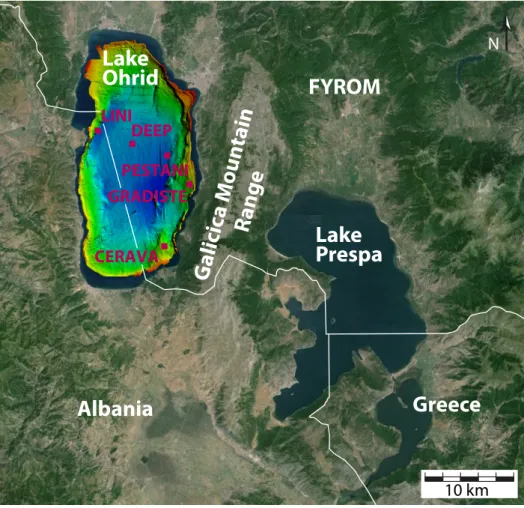
Lake Ohrid, comprising of about 358 km
2, is approximately 30 km long and 15 km wide (cf. Fig. 1.3).
The lake is situated at 693 m a.s.l. and is surrounded by mountains up to 2 300 m a.s.l.. The maximum
water depth is about 289 m with a relative simple tube-shape bathymetry and a mean water depth of
151 m (see Fig. 1.3, and summerized e.g. by Wagner et al., 2009; Vogel et al., 2010b). The main amount
(55%) of the hydrologic input to Lake Ohrid originates from nutrient depleted carstic springs (Matzinger
et al., 2006). 50% of this water originates from Lake Prespa, which is located about 150 m higher as
Lake Ohrid (Fig. 1.3). Both lakes are connected via carst aquifers but they are topographically separated
1. Introduction
by the Galicica Mountain Range (Fig. 1.3). River and surface inflow and direct precipitation cover the remaining 45% of the hydrologic input to Lake Ohrid (Matzinger et al., 2006). Including Lake Prespa, Lake Ohrid comprises a catchment area of 2 393 km
2. The only outflow of Lake Ohrid, the Crni Drim in northern parts of the lake, accounts for about 63% of the water loss of the lake. The remaining 37%
are evaporated from the lake surface (Watzin et al., 2002; Matzinger et al., 2006). Due to the large water volume and to a low nutrient availability, Lake Ohrid is highly oligotrophic today (Stankovic, 1960; Matzinger et al., 2007; summarized by Vogel et al., 2010b). Enhanced productivity in the past is associated with more nutrient supply via the carst system during lake-level low-stands at Lake Prespa (Matzinger et al., 2006). Additionally, increased productivity is associated with a complete overturn of the entire water column. This mixing transfers dissolved phosphorous to the epilimnion (Wagner et al., 2009) and occurs approximately every 7 years (Matzinger et al., 2007). An overturn of the upper 200 m of the water column persists annually during wintertime and thermal stratification during the summer months (Matzinger et al., 2007).
10 km
Lake Ohrid
Lake Prespa
Albania
FYROM
Greece
N
G alici ca M ou ntain
Range
LINI DEEP
CERAVA GRADISTE
PESTANI
Figure 1.3:Lakes Ohrid and Prespa located at the borders of the Former Yugoslav Republic of Macedonia (FYROM), Albania and Greece, including a bathymetric map of Lake Ohrid (Lindhorst et al., 2012). Marked are the ICDP sites DEEP, CERAVA, GRADISTE, and PESTANI which were drilled in spring 2013. At LINI, a 10 m long sediment sequence was allready recovered in 2011. (map: google earth: c2014 DigitalGlobe, c2013 Google, Image Landsat).
Jurassic to Cretaceous ultramafic rocks to the southwest and west form the bedrock in the surroundings of Lake Ohrid (Vogel et al., 2010b). In the plains to the north and to the south of the lake, the bedrock is overlain by Quaternary lacustrine and fluvial sediments (cf. Vogel et al., 2010b).
The climate at Lake Ohrid is influenced by both, continental and Mediterranean conditions, with maximum air temperatures below 31.5
◦C, minimal temperatures above -5.7
◦C, a mean annual air temperature of 11.1
◦C, and an average annual precipitation of 800 to 900 mm between 1961 and 1990 (summarized by Vogel et al., 2010b). The prevailing wind directions are north and south.
A 568 m long sediment core (DEEP site) was retrieved from central parts of Lake Ohrid within the
scope of the ICDP SCOPSCO project (Scientific Collaboration on Past Speciation Conditions in Lake
Ohrid) in spring 2013 (Fig. 1.3). Preliminary data imply that the sequence covers the entire lacustrine
sediment succession of the lake, promising to provide a valuable record of environmental variability and
tephrostratigraphy in the Mediterranean Region. During the deep drilling campaign, long sediment cores
were also recovered at CERAVA, GRADISTE, and PESTANI-site (Fig. 1.3). Previous studies on surface
sediments (Vogel et al., 2010a) and sediment cores that cover the last glacial-interglacial cycle (Wagner
et al., 2009; Vogel et al., 2010b) have already demonstrated the potential of Lake Ohrid deposits to
record crucial information about modern and past sedimentary processes in the lake. These sedimentary
processes could be linked to variations in the environmental settings and to the climatic conditions in the
area (e.g. Wagner et al., 2009; Leng et al., 2010; Vogel et al., 2010b; Wagner et al., 2010), as well as to
the deposition of tephralayers and cryptothephralayers (Wagner et al., 2008a; Caron et al., 2010; Sulpizio
et al., 2010; Vogel et al., 2010c). In addition, multiple mass wasting deposits have been observed in Lake
Ohrid (Wagner et al., 2008b; Lindhorst et al., 2010). In order to obtain more information about past
sedimentary processes in Lake Ohrid, a 10 m long sediment sequence was recovered from western parts
of Lake Ohrid close to the Lini Peninsula (LINI-site, Fig. 1.3), which is analyzed within the scope of
this thesis.
1. Introduction
1.3 Objectives
The main objective of this study is to improve the knowledge of sedimentary processes in lakes El’gygytgyn, Dojran and Ohrid as a basis for subsequent paleoenvironmental and -climatological re- constructions. The investigations are part of international research projects. The obtained sedimentary, geochemical and biogeochemical data were used to:
• provide information about external and internal sedimentary processes in the respective lake and lake’s area, and to provide a basic sedimentary datasets for the studies of international research collaborators
• obtain information about paleoenvironmental and -climatoligical variability in the respective lake history
• discuss the potential and limits of the used proxy data, chronology, and statistic methods that were used in the individual publications.
Chapters 2 to 5 present the research at Lake El’gygytgyn which was conducted within the scope of the
“Lake El’gygytgyn Drilling Project“. In order to improve the knowledge about the deposition of clastic material in Lake El’gygytgyn as a basis for interpretations of the long sediment succession, modern sedimentary processes are investigated in chapter 2. For this purpose, multivariate statistic methods are applied to granumoleric, geochemical, biogeochemical and mineralogical data from lacustrine surface sediments, inlet streams and bedrock samples.
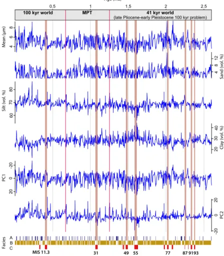
Chapter 3 presents the granumoleric data of the Quaternary sediment sequence of core 5011-1.
Variations in the downcore grain-size data are interpreted in terms of variations in past sedimentary processes. A Principal Component Analysis (PCA) combined with time series analysis yield crucial information about the frequency in the data and the relative dominance of the oscillations during the Quaternary. These oscillations in the grain-size distribution can be explained by climate variability on glacial/interglacial time scales and by Northern Hemisphere insolation variations.
In chapter 4, the link of grain-size data and other parameters (color, magnetic susceptibility, biogenic silica, organic content, X-ray fluorescence (XRF) scanning data, pollen) to global climate variability is used to establish the chronology of core 5011-1. Paleomagnetic data indicating major reversals in the Earth’s magnetic field provid initial tie points for the age model. The sediment parameters are subsequently tuned synchronously to Northern Hemisphere insolation variations and to the marine isotope stack LR04 (Lisiecki and Raymo, 2005).
Chapter 5 focuses on the petrophysical characterization of the Lake El’gygytgyn sediment sequence by
using geophysical and chemical data. Seismic and downhole logging data are used to identify stratified
and discontinuous parts in the sediment succession in order to detect mass movement deposits, and to
characterize the transition from the bedrock to the lacustrine deposits. Physical and chemical parameters
measured on the cores are used to divide the lacustrine sediment sequence into five different statistical
clusters.
δ
18O
carb, δ
13C
carb, δ
13C
org) of a 7 m long sediment core (Fig. 1.2B). The research of this study is incor- porated into the CRC “Our way to Europe“, which aims to capture the complex nature of chronology, regional structure, climatic, environmental and socio-cultural contexts of the dispersal of Modern Man from Africa to Western Eurasia, and particularly to Europe.
Chapter 7 focuses on probable triggers of the sedimentation of a MWD in Lake Ohrid (Macedonia, Albania), which is characterized using sediment (lithostratigraphic description, XRF scanning, water content, OM content, calcite content) and hydro-acoustic data. The MWD is temporally constrained by tephrostratigraphic tie points, radiocarbon dating, and cross correlation to existing cores. The research of this study contributes to the ICDP SCOPSCO project. The aims of this project are to (I) obtain more precise information about the age and origin of the lake, (II) unravel the seismotectonic history of the lake area including effects of major earthquakes and associated mass wasting events, (III) obtain a continuous record containing information on volcanic activities and climate changes in the central northern Mediterranean region, and (IV) better understand the impact of major geological/environmental events on general evolutionary patterns and shaping an extraordinary degree of endemic biodiversity as a matter of global significance.
In chapter 8, the potentials and the limits of the data and methods used in the previous chapters are dis- cussed. In chapter 8.1, granumoleric and geochemistry data from lacustrine surface sediments and from catchment samples from inlet streams and source rocks are assessed for their potential to unravel modern sedimentary processes. Information about spatial variations of past to modern sedimentary processes can be investigated by using hydro-acoustic data, which is discussed in chapter 8.2. More detailed informa- tion about past sedimentary processes in a lake system can be obtained from sediment cores by analyzing their lithological properties, grain-size variability, and inorganic and organic geochemistry composition.
The potential and limits of these data including systematical and analytical errors are assessed in chapter
8.3. Chapter 8.4 focuses on the age modeling of lacustrine sediment sequences and the consequences
of different methods for the interpretations of sedimentary, paleoenvironmental and -climatologic vari-
ations in a temporal context. Finally, the utility of multivariate statistic methods such as the Principal
Component Analyses (PCA) and the Redundancy Analyses (RDA) is evaluated in chapter 8.5.
2. Modern sedimentation patterns in Lake El’gygytgyn, NE Russia, derived from surface sediment and inlet streams samples
2 Modern sedimentation patterns in Lake El’gygytgyn, NE Russia, derived from surface sediment and inlet streams samples
Journal article (2013):
Wennrich, V., Francke, A., Dehnert, A., Juschus, O., Leipe, T., Vogt, C., Brigham-Grette, J., Minyuk, P.
S., Melles, M., and El’gygytgyn Science, P.: Modern sedimentation patterns in Lake El’gygytgyn, NE
Russia, derived from surface sediment and inlet streams samples, Clim. Past, 9, 135-148, 10.5194/cp-9-
135-2013, 2013.
doi:10.5194/cp-9-135-2013
© Author(s) 2013. CC Attribution 3.0 License.
of the Past
Modern sedimentation patterns in Lake El’gygytgyn, NE Russia, derived from surface sediment and inlet streams samples
V. Wennrich1, A. Francke1, A. Dehnert2, O. Juschus3, T. Leipe4, C. Vogt5, J. Brigham-Grette6, P. S. Minyuk7, M. Melles1, and El’gygytgyn Science Party
1University of Cologne, Institute for Geology and Mineralogy, Cologne, Germany
2Swiss Federal Nuclear Safety Inspectorate ENSI, Brugg, Switzerland
3Eberswalde University for Sustainable Development, Eberswalde, Germany
4Leibniz Institute for Baltic Sea Research Warnemuende, Marine Geology, Rostock, Germany
5University Bremen, Department of Geosciences, Crystallography/ZEKAM, Bremen, Germany
6University of Massachusetts, Department of Geosciences, Amherst, USA
7Russian Academy of Sciences, Northeast Interdisciplinary Scientific Research Institute, Magadan, Russia Correspondence to:V. Wennrich (volker.wennrich@uni-koeln.de)
Received: 27 April 2012 – Published in Clim. Past Discuss.: 1 June 2012
Revised: 19 October 2012 – Accepted: 10 December 2012 – Published: 22 January 2013
Abstract.Lake El’gygytgyn/NE Russia holds a continuous 3.58 Ma sediment record, which is regarded as the most long- lasting climate archive of the terrestrial Arctic. Based on multi-proxy geochemical, mineralogical, and granulometric analyses of surface sediment, inlet stream and bedrock sam- ples, supplemented by statistical methods, major processes influencing the modern sedimentation in the lake were inves- tigated. Grain-size parameters and chemical elements linked to the input of feldspars from acidic bedrock indicate a wind- induced two-cell current system as major driver of sediment transport and accumulation processes in Lake El’gygytgyn.
The distribution of mafic rock related elements in the sed- iment on the lake floor can be traced back to the input of weathering products of basaltic rocks in the catchment. Ob- vious similarities in the spatial variability of manganese and heavy metals indicate sorption or co-precipitation of these el- ements with Fe and Mn hydroxides and oxides. But the sim- ilar distribution of organic matter and clay contents might also point to a fixation to organic components and clay min- erals. An enrichment of mercury in the inlet streams might be indicative of neotectonic activity around the lake. The results of this study add to the fundamental knowledge of the modern lake processes of Lake El’gygytgyn and its lake- catchment interactions, and thus, yield crucial insights for the interpretation of paleo-data from this unique archive.
1 Introduction
In spring 2009, the ICDP El’gygytgyn Drilling Project re- covered the 318-m long lacustrine sediment record of Lake El’gygytgyn in Chukotka, NE Russia (Melles et al., 2011, 2012; Fig. 1). Long high-resolution lake sediment records are known to well document regional hydrologic and cli- matic responses to atmospheric changes (Brigham-Grette et al., 2007a), and therefore are valuable archives of climate and environmental changes (e.g. Allen et al., 1999; Gasse et al., 2011; Cohen, 2012). Given their often continuous sediment sequences, large and old lake basins play an important role in collecting sedimentological information providing a conti- nental signature to couple with the marine realm. Thus, these lakes help to close gaps in the knowledge on land–ocean in- teractions through time. Nevertheless, the profound interpre- tation of proxy data derived from lake sediment records re- quires an in-depth knowledge of the lake-specific modern bi- ological and sedimentological processes and their controlling factors (e.g. Vogel et al., 2010; Viehberg et al., 2012).
Lake El’gygytgyn represents a unique site, because it holds the most long-lasting climate archive of the terres- trial Arctic (Melles et al., 2011, 2012), reaching back to the time of meteorite impact event 3.58 Ma ago (Layer, 2000).
Furthermore, the basin was never overcome by large Ceno- zoic continental ice-masses (Glushkova, 2001; Glushkova
Published by Copernicus Publications on behalf of the European Geosciences Union.
136 V. Wennrich et al.: Modern sedimentation patterns in Lake El’gygytgyn
Figure 1
8 9 5 4 3 2 1
10 11 12 6 7
0 1 2 3 4 5 km Sea
SIBERIA ALASKA
Arctic Ocean
°N 70
150°W 60°N 150°E 180°
Lake El‘gygytgyn
a
b
Bering
520500 560540
-170 -160 -150
Fig. 1. (a)Map showing the location of Lake El’gygytgyn in the western Beringian Arctic,(b)geological map of the El’gygytgyn impact impact crater illustrating the major stratigraphic units (mod- ified after Nowaczyk et al., 2002) and major fault systems (compiled after Belyi and Belaya, 1998; Belyi and Raikevich, 1994) in the lake catchment, bathymetric contour lines in the lake (modified after Be- lyi, 2001), and locations of lake floor and bedrock samples used in this study as well as of ICDP site 5011-1.; (1) Koekvun’ Formation (basalt, andesite-basalt, tuff, tuff-breccia, sandstone, tuff-siltstone), (2) Ergyvaam Formation (ignimbrite, tuff), (3) Pykarvaam Forma- tion (ignimbrite, tuff), (4) Voron’in Formation (ignimbrite, tuff), (5) dykes, stocks, and sills of subvolcanic rocks, (6) flood plain de- posits, (7) terrace deposits, (8) boundary between the outer and in- ner OCVB zones, (9) major faults, (10) lake sediment surface sam- ples, (11) bedrock samples (with squares referring to data from this study and triangles to data taken from Belyi and Belaya, 1998), (12) ICDP site 5011-1.
and Smirnov, 2007), resulting in widely time-continuous sed- imentation. The lake is located in a region influenced by both Siberian and North Pacific oceanic air-masses (Barr and Clark, 2011; Yanase and Abe-Ouchi, 2007; Mock et al., 1998), making it very sensitive to regional atmospheric change. The high potential of Lake El’gygytgyn as a globally significant paleoclimate and environmental archive is con- firmed by numerous studies on the lake sediments formed during the past three glacial/interglacial cycles (Brigham- Grette et al., 2007b; Lozhkin et al., 2007; Melles et al., 2007;
Minyuk et al., 2007; Nowaczyk et al., 2007; Swann et al., 2010; Asikainen et al., 2007).
Within the framework of the pre-site survey research, modern climatological and hydrological processes in the lake surrounding and in the water column were intensively inves-
tigated (e.g. Cremer and Wagner, 2003; Cremer et al., 2005;
Nolan and Brigham-Grette, 2007; Nolan et al., 2002; Fe- dorov et al., 2012), and a variety of modern to sub-recent sample sets were taken for study (Melles et al., 2005).
Here, we present the combined results of a multi-proxy and statistical approach to enhance the understanding of the modern sedimentation of Lake El’gygytgyn by analyzing a set of surface sediment and inlet streams samples, as well as hand samples from the surrounding bedrock. The major goal of this study is to provide information concerning the dominant sedimentation patterns in the lake controlled by climate-driven transport processes, bedrock geology, post- depositional processes, but possibly also influenced by tec- tonic activity. In combination with recent climatologic and hydrologic data (Nolan, 2012; Fedorov et al., 2012), these findings will enhance our understanding of fundamental in- lake processes, and thus, form an important basis for the in- terpretation of the Lake El’gygytgyn paleo-record extending to 3.58 Ma.
2 Study site
Lake El’gygytgyn (67 300N, 172 050E, 492 m a.s.l.; Fig. 1) is located within the Anadyr Mountain Range in central Chukotka/ Far East Russian Arctic. Today, the roughly cir- cular lake has a diameter of⇠12 km and a maximum wa- ter depth of 175 m (Nolan and Brigham-Grette, 2007; Melles et al., 2007), filling the deepest part of the⇠18-km wide El’gygytgyn impact crater (Gurov et al., 2007). With a sur- face area of ⇠110 km2, the lake is fed by 50 ephemeral streams draining a watershed area of 293 km2defined by the crater rim (Nolan et al., 2002; Fig. 2a). The outlet stream, the Enmyvaam River at the south-eastern edge of the lake, flows into the Anadyr River, which eventually drains into the Bering Sea (Nolan and Brigham-Grette, 2007).
The climate in Chukotka is characterized by low mean winter and summer temperatures between 32 C and 36 C (January) and between +4 and +8 C (July, Au- gust), respectively (Treshnikov, 1985), and a mean annual precipitation of⇠250 mm (Glotov and Zuev, 1995). In 2002, winter and summer temperature extremes of 40 C and +26 C, respectively, were recorded at Lake El’gygytgyn (Nolan and Brigham-Grette, 2007). Strong winds either from the north or south with a mean hourly wind speed of 5.6 ms 1 were punctuated by maximum values up to 21.0 ms 1(Nolan and Brigham-Grette, 2007).
Lake El’gygytgyn is an oligotrophic to ultra-oligotrophic and cold-monomictic lake (Cremer and Wagner, 2003), with a yearly ice-cover lasting from mid-October until early to mid-July (Nolan et al., 2002). While thermal stratification of the water column is today established during the ice-covered season (Cremer et al., 2005), the lake becomes fully mixed by late summer after snowmelt and the initial ice break-up, triggered by the lateral movement of warmer shore-waters
Clim. Past, 9, 135–148, 2013 www.clim-past.net/9/135/2013/
2. Modern sedimentation patterns in Lake El’gygytgyn, NE Russia, derived from
surface sediment and inlet streams samples
Outlet Outlet
Outlet Silt (%)
0 10 20 30
Clay (%)
0 20 40 60 80
Outlet Sand (%)
0 20 40 60 80
Outlet
5 25 45 65 85 105 125
Outlet
Mean (µm) b
c
f d a
e
4142 4344
4546 4748
49 50 2 1 4 3 65 87 109 11 12 1413 17181915162021 222325242726 31
2930 28
323334 35363738 3940
15 19 23 27 31 35 39 43 47 51
Feldspars (%) Quartz (%)
1 5 9 13 17 21 25 29 33 3741
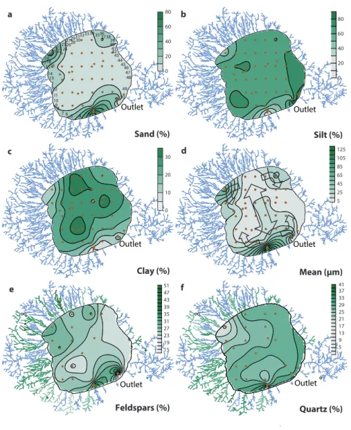
Fig. 2.Spatial distribution of volume percentages of(a)sand,(b)silt and(c)clay,(d)mean grain size, and proportions of(e)feldspars and (f)quartz in modern surface sediments (brown dots=sample location), inlet streams (coloured streams) and bedrock samples (coloured cir- cles) of Lake El’gygytgyn. Numbers near the stream mouths in(a)refer to the creek numbering system of Nolan and Brigham-Grette (2007).
Arrows in(d)indicate the near-surface circulation pattern, created by prevailing northern and southern wind directions (modified after Nolan and Brigham-Grette, 2007). Note that data of inlet stream and bedrock samples are only available for(e)and(f).
and enhanced by strong winds (Nolan and Brigham-Grette, 2007). The residence time of the lake water was calculated to be⇠100 yr (Fedorov et al., 2012).
Geomorphological studies in the lake catchment have identified prominent lake terraces at 35–40 m, 9–11 m and 3–5 m above the modern lake level as remains of lake-level high-stands during the lake history (Glushkova and Smirnov, 2007; Schwamborn et al., 2008a, 2006). In addition, an an-
cient terrace 10 m below the modern water level points to a significant lake-level lowering, most likely during MIS 2 (Juschus et al., 2011). Although the existence of higher ter- races 60 and 80 m above the recent lake level has been sug- gested (Gurov et al., 2007; Nekrasov, 1963), their lacustrine origin has not yet been finally confirmed (Glushkova and Smirnov, 2005; Juschus et al., 2011).
www.clim-past.net/9/135/2013/ Clim. Past, 9, 135–148, 2013
138 V. Wennrich et al.: Modern sedimentation patterns in Lake El’gygytgyn The El’gygytgyn impact crater was formed in Upper Cre-
taceous volcanic rocks of the Okhotsk–Chukchi Volcanic Belt (OCVB) (Gurov et al., 2007; Gurov and Gurova, 1979).
The bedrock in the vicinity of the lake predominantly con- sists of ignimbrites, tuffs and andesite-basalts associated with the Pykarvaam, Voron’in, Koekvun’ and Ergyvaam Formations (Belyi and Raikevich, 1994; Nowaczyk et al., 2002; Fig. 1b) dated to about 67–90 Ma (Kelley et al., 1999;
Stone et al., 2009). The region of Lake El’gygytgyn is af- fected by continuous permafrost, presumably since the Late Pliocene (Glushkova and Smirnov, 2007). Erosion and detri- tal sediment transport of bedrock material into the lake basin are mainly triggered by permafrost related cryogenic weath- ering, as well as slope dynamics, and fluvial outwash in the lake surrounding (Schwamborn et al., 2008b, 2012; Fedorov et al., 2012). Thus, climate-driven variations in permafrost stability are believed to have a major influence on the lake sedimentation.
3 Material and methods 3.1 Field work
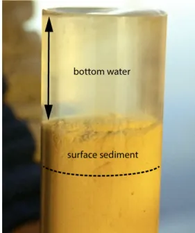
During a field campaign in summer 2003, a set of 55 sur- face sediment samples was collected from the floor of Lake El’gygytgyn (Fig. 1b). The samples were recovered from a floating platform using a gravity corer (UWITEC Corp., Aus- tria) with plastic liners of 6 cm in diameter. Sample locations were determined according to a regular map grid, except for the shallowest parts of the lake, which were sampled along a transect at the southern shelf and at three sites along the southeastern shelf. This study is based on the uppermost 2 cm of the gravity cores, which represents roughly the past 150 years based on Holocene sedimentation rates (Fig. 3).
To investigate the influence of both fluvial sediment sup- ply and bedrock geology on the modern sediments of Lake El’gygytgyn, an additional 30 sediment samples were taken from the major inlet streams entering the lake, and another 11 bedrock samples were collected from the lake catchment (Fig. 1b). The bedrock samples were supplemented by addi- tional XRF data of bedrock samples taken from the literature (Belyi and Belaya, 1998).
3.2 Analytical work
Sediment samples from both the lake floor and inlet streams were freeze-dried in the lab and subsequently split into sam- ple aliquots. Aliquots for geochemical and biogeochemical analyzes were ground to<63 µm and homogenized. To- tal nitrogen (TN) was measured with an elemental analyzer (vario EL III, elementar Corp.). The total organic carbon con- tent (TOC) was measured using a METALYT CS 1000S an- alyzer (ELTRA Corp.), after pretreating the sediment with 10 % HCl to remove carbonates.
Fig. 3.Photograph of a gravity core taken near the northern shore of Lake El’gygytgyn from a water depth of 127.4 m. Surface samples used in this study comprise the uppermost 2 cm of the sediments (above the dotted line) representing roughly the past 150 yr based on Holocene sedimentation rates.
Major and trace elements were measured by ICP-OES (iCAP 6300 DUO, Thermo Scientific) after HClO4/HF total digestions. Acid digestion was performed in closed Teflon vessels (PDS-6) heated for 6 h at 180 C by treating 100 mg sample with 3 mL HF+1 mL HClO4. After digestion, acids were evaporated using a heated metal block (180 C) and were re-dissolved and evaporated three times with 3 mL half- concentrated HCl, followed by re-dissolution with 2 vol%
HNO3and dilution to 25 mL. Precision (1 ) and accuracy were checked by parallel analysis of international and in- house reference materials, leading to2.8 to2.6 % for major elements and1.7 to12.1 % for trace metals. Mer- cury was directly determined using 30–50 mg of dry homog- enized sediment using a DMA-80 Direct Mercury Analyzer (MLS instruments). The analysis is based on combustion of the sample and pre-concentration of Hg at a gold trap (amal- gam), re-heating and determination of Hg gas by atomic- absorption spectrometry (AAS). The detection limit of the analysis is very low (<1 µg kg 1) and the reproducibility (precision) is⇠5 % relative to the standard deviation from the average value.
The major and trace element composition of the bedrock samples was determined by wavelength-dispersive X-ray flu- orescence (XRF) analysis using a sequential X-ray spectrom- eter (Phillips PW2400) calibrated with natural and synthetic
Clim. Past, 9, 135–148, 2013 www.clim-past.net/9/135/2013/
2. Modern sedimentation patterns in Lake El’gygytgyn, NE Russia, derived from
surface sediment and inlet streams samples
standards. Prior to analysis, powdered samples were heated for four hours at 105 C before fusion with Li2B4O7.
Bulk mineral contents of selected surface sediment (n= 22), stream (n=23) and bedrock samples (n=7) were de- termined by X-ray diffraction (XRD). XRD analyses were run on pressed powder pellets using a Philips PW 1820 diffractometer with CoK↵ radiation (40 kV, 40 mA), auto- matic divergence slit (ADS), graphite monochromator, and automatic sample changer. Scanning was performed from 3 to 100 2theta with a step size of 0.02 2theta and 1 seconds time per step. Mineral identifications were done by means of the Philips software X’Pert HighScore™ and sheet silicates were identified and quantified with the X-ray diffraction interpretation software MacDiff 4.25 (Petschick et al., 1996). Full quantification of the bulk mineral assem- blage was carried out using the QUAX software package (Emmermann and Lauterjung, 1990) following the QUAX full pattern method (Vogt et al., 2002). The standard de- viation for bulk mineral determination is±2 % for quartz (Vogt, 1997) and±5–10 % for feldspars and clay minerals (Vogt et al., 2002).
Grain-size analyses were performed on 1 g freeze-dried sediment. Prior to the measurement, samples were pre- treated according to Francke et al. (2013) to remove organic matter (30 % H2O2, 50 C, 18 h), vivianite nodules (0.5 M HNO3, 50 C, 5 h, 30 min shaking in between) and biogenic silica (0.5 M NaOH leaching, 90 C, 2⇥30 min.). The re- sults of the treatment steps were validated by biogeochemical analyses, Fourier Transform Infrared Spectroscopy (FTIRS), XRD, scanning electron microscopy (SEM) and optical mi- croscopic investigations (Francke et al., 2013). Subsequently, the samples were mixed with Na4P2O7solution (0.05 % w/v) as a dispersant agent and finally measured by a Laser Par- ticle Size Analyzer (DigiSizer 5200, Micromeritics Instru- ment Corp.). The laser-diffractometer uses a 1MB CCD- sensor and calculates 160 grain-size classes between 0.1 and 1000 µm with average values of three runs. One minute of ul- trasonic treatment and flow rates of 10 L min 1re-suspended the sediments prior to the analysis.
3.3 Statistics and interpolation
Calculations of grain-size parameters and statistics were per- formed using the program GRADISTAT (Blott and Pye, 2001). The statistical grain-size parameters were calculated according to the arithmetic method of moments.
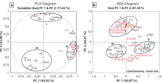
To handle and simplify the element data of the surface sediments, and to visualize grain-size dependencies, both principal component analysis (PCA) and redundancy analy- sis (RDA) were carried out. Analyses were conducted using the Microsoft Excel add-in XLSTAT (Addinsoft SARL) with chemical element data as dependent response variables and various grain-size parameters (mean, mode, median, percent- ages of sand, mud, silt, clay, medium sand, fine sand, very
fine sand, very coarse silt, coarse silt, medium silt, fine silt, very fine silt) as explanatory variables, respectively.
Interpolation and mapping of the surface sediment datasets were performed with the software Surfer 9 (Golden Software Inc.) using the Kriging method (Cressie, 1991; Oliver and Webster, 1990).
4 Results
4.1 Grain-size distribution
The surface sediments of Lake El’gygytgyn are silt domi- nated (Fig. 2b) with a mean grain-size ranging between 7.3 and 69.6 µm (Fig. 2d). The spatial distribution of the mean grain-size shows fine-grained sediments in the northern, east- ern and western central lake basin, whereas coarser mate- rial is found at the southern, northwestern and northeast- ern edges of the lake (Fig. 2d). Coarse-grained areas with high sand content (>63 µm) up to 73.8 % are located in the northwestern and northeastern corners of the lake and along the southern shore (Fig. 2a). Highest silt contents (2–63 µm) with maximum values up to 82.3 % (Fig. 2b) are observed at the southeastern edge of the basin near the mouth of creeks 49 and 50 (creek numbers according to Nolan et al., 2002;
Fig. 2a). The clay content varies between 8.4 % at the south- ern shore and 33.6 % in the central lake basin (Fig. 2c).
Surprisingly, the center of the lake exhibits a tongue of sediments with higher mean grain sizes around 15–25 µm, extending from the southern shore towards the lake center (Fig. 2d). This feature is mainly due to a slight shift of the mean caused by an increase in very coarse silt (31–63 µm) of up to 17 %.
4.2 Bulk mineralogy
The bulk mineral composition of the surface sediments is dominated by a mixture of quartz, feldspars (plagioclase and K-feldspars), clay minerals and accessory minerals (Table 1).
Although bedrock samples of the catchment contain fairly scattered amounts of quartz ranging from 2.9–27.7 %, the surface sediment and inlet stream samples show a rather het- erogeneous quartz distribution with a clear enrichment (up to 34.3 %) at the southern and southeastern shore (Fig. 2f). Con- versely, the northwestern shore is characterized by lowest quartz content.
Feldspars also exhibit high concentrations in the sur- face sediments at the southern and northeastern shores (max. 42.5 %) but differ from quartz due to the high con- centration also found at the northwestern shore and a pro- nounced low in the central and eastern part of the lake (max. 22.8 %; Fig. 2e). These values fit within the con- centration range of the inlet stream samples (25.4–40.0 %) and of the bedrock material (15.1–51.4 %; Fig. 2e). In the latter, feldspars occur as phenocrysts of orthoclase (KAlSi3O8) and plagioclase, mainly of oligoclase and
www.clim-past.net/9/135/2013/ Clim. Past, 9, 135–148, 2013
![Fig. 5. Spatial distribution of concentrations of (a) K 2 O [% wt/wt], (b) Cr [mg kg 1 ], (c) MnO [% wt/wt], (d) Hg [µg kg 1 ], (e) TOC [%](https://thumb-eu.123doks.com/thumbv2/1library_info/3691340.1505600/27.892.190.700.212.824/fig-spatial-distribution-concentrations-cr-mno-hg-toc.webp)