Community patterns and recruitment of fish in a large temperate river floodplain
-
The significance of seasonally varying hydrological conditions and habitat availability
I n a u g u r a l - D i s s e r t a t i o n zur
Erlangung des Doktorgrades
der Mathematisch-Naturwissenschaftlichen Fakultät der Universität zu Köln
vorgelegt von Andreas Peter Scharbert
aus Willich
Köln
2009
Prof. Dr. Hartmut Arndt
Tag der mündlichen Prüfung: 21.10.2009
„Das Prinzip aller Dinge ist das Wasser, denn Wasser ist alles und ins Wasser kehrt alles zurück.“
Thales von Milet (griechischer Philosoph ~ 625 - ~ 547 v.Chr.)
für viele gute Ideen und Ratschläge, für seine Nachsicht und Unterstützung und die zahlreichen Wochenendschichten in der Schlussphase der Arbeit
Prof. Dr. Hartmut Arndt für die Übernahme des Koreferats, für seine Geduld und seinen Optimismus
Besonderer Dank gilt meiner Lebensgefährtin Bozena Hermasch für ihre Hilfe bei den Untersuchungen, ihren Beistand in allen Lebenslagen, für das Aufmuntern, die zahlreichen Entbehrungen, das leibliche Wohl, die mathematischen Diskussionen und für das Dasein
Den Protagonisten der „Jugend-forscht“ Truppe (Lisa Heermann, Werner Scharf, Ulrike König, Joscha Groddek, Peter Beeck, Andreas Zipperle, Patricia Murawski), ohne deren Hilfe im Freiland diese Arbeit nicht hätte durchgeführt werden können, für die angenehme Zeit in der Grietherbuscher WG und ihre Freundschaft
Armin Lorenz und Daniel Hering für zahlreiche Ratschläge und Hilfestellungen in Ordinationsbelangen
Ulrich Werneke für die Hilfe bei Freilanduntersuchungen, den Tiefenlotungen und GIS-Problemchen
Stefan Staas und Fabio Rochol für das Rückenfreihalten auch wenn im Büro die Hölle los war, die fachlichen Diskussionen und ihre Freundschaft
Christoph Schiawo für die Hilfe bei den Untersuchungen, auch nach Feierabend, das Instandhalten der Gerätschaften und seiner Frau Iris dafür, dass man sich in der Station immer wohl fühlen durfte
Heinrich Evers für seine Ortskenntnisse, und für die Zerstreuung bei den Kaffeepäuschen
Den Fischern Rudi Hell und Horst Liebsch für den Verzicht der Nutzung ihrer Pachtgewässer in der Zeit in der ich dort forschte und Hilfe bei Stellnetzbefischungen
Stellvertretend für die Flächeninhaber, -betreuer und Landwirte die mir den Zugang
zu den Untersuchungsgewässern ermöglicht haben, möchte ich stellvertretend Herrn
Gottschalk vom F
ORSTAMTW
ESEL, Herrn Schulze vom R
EGIONALVERBANDR
UR,
Heiko Geyer vom R
EGIONALVERBANDR
UHRfür den Zugang zu den Luftbildservern des RVR und Martina Erzner (B
IOLOGISCHES
TATION IMK
REISW
ESEL) für die nützlichen Hinweise hinsichtlich des Schreibens der OGC-files
Barbara Guhl und Herrn Ulkan (L
ANUVNRW) für das zur Verfügungstellen der Temperaturdaten des Rheins
Frau Rubart vom WSA Duisburg für die Zusendung der Abflussdaten des Rheins Pavel Jurajda für die konstruktiven Anmerkungen hinsichtlich früherer Versionen einzelner Manuskripte dieser Arbeit
Meinen Eltern Siegfried und Christa weil sie mir die mir die Durchführung des Studiums überhaupt erst ermöglicht haben, für ihre Rückendeckung in allen Phasen meiner Ontogenese und dafür dass sie meine Entscheidungen stets akzeptiert haben Zoltan für die Frischluft- und Bewegungseinheiten, ohne die ich wahrscheinlich eingegangen wäre und seine Treue
Manuel Langkau und Egbert Franke für die Momente der profanen Annäherung an das Themenfeld der Fischökologie
und Diane für ihr immer offenes Ohr und ihr gutes Gedächtnis
Introduction 9 I. Relationships of hydrology and life-history strategies on spatio-temporal
habitat utilisation of fish in European temperate river floodplains 28 II. Determinants of recruitment and mortality of YOY-fish cohorts within
floodplain lakes during the isolation phase 73 III. Causes and consequences of piscivory in young-of-the-year pikeperch and
perch in floodplain lakes of a large temperate lowland river 107 Appendix
1. Point abundance sampling by electrofishing and density estimation in
floodplain lakes 143
Table A1 – Total catch 149
Abstract 151
Zusammenfassung 155
Introduction
Most large alluvial temperate rivers all over the world have undergone drastic anthropogenically induced changes in the past centuries (Petts, Möller, and Roux 1989; Dynesius and Nilsson 1994; Kern 1994; Cowx and Welcomme 1998; Buijse et al. 2002). Due to the fertility of the alluvial deposits and despite the risk of seasonal flooding, river floodplain areas have been early reclaimed for colonisation, cultivation, and agricultural utilisation. In Europe deforestation of river basins has started in prehistoric times and was yet almost completed in some densely populated regions in the middle ages. In the following centuries many rivers were shortened, canalised, their beds deepened and reinforced. Levees were raised to protect the mostly densely populated areas of the river basins from seasonal floods. These modifications were often followed by deleterious direct and indirect impacts on the rivers hydrological characteristics, including strongly increasing flood peaks, however shortened flood durations and disturbed sediment loads (Buijse et al. 2002).
Furthermore they led to a fragmentation of habitats, and headwater regions were often disconnected from downstream areas for migratory fish. As a consequence and in combination with intensive fishing, stocks of migratory fish and their fishing yield in many European rivers declined sharply (Böcking 1982; De Groot 2002). Although the relationship of threads for fish stocks arising from longitudinal river fragmentation has been addressed early, e.g. documented by the “Lachsvertrag” from 1885 (Iksr 1999), the consequences of the lateral dimensions of river modifications, by either losses of floodplain area or disturbed interactions between rivers and its wetlands have been overseen for a long time. The findings of Antipa (1910; 1923), who firstly addressed the recruitment and productivity of potamal fish species in the lower Danube to the extent and duration of floodplain inundation, are the earliest deliverances that stressed the significance of such interactions for riverine fish populations, what has been repeatedly confirmed for upstream sections of the Danube in the following decades (Balon 1963; Balon 1966; Stankovic and Jankovic 1971; Holcik and Bastl 1976). Numerous studies conducted in the last 30 years in temperate systems found similar relationships of productivity and the degree of connectivity to occur in further biota, e.g. peaking abundances of phytoplanctonic and zooplanctonic organisms in inundated stagnant floodplain waterbodies relative to the river channel (Amoros and Roux 1988; Admiraal et al. 1994; Hein et al. 1999;
Baranyi et al. 2002; Keckeis et al. 2003), or even with respect to nutrient cycling,
energy flow and food webs (Tockner et al. 1999; Woodward and Hildrew 2002;
Winemiller 2004). Many ecological theories and concepts arising from these relationships stress the four-dimensionality of processes in aquatic environments, which involve vertical (e.g. between the water column and the hyporheic zone, the groundwater table), longitudinal (along the tributaries and the river course) and lateral (between the river and its riparian zones, the floodplain) exchanges, however, particularly emphasise the role of the 4
thdimension, the time (Junk, Bayley, and Sparks 1989; Ward 1989; Ward and Stanford 1995; Junk 1999; Tockner, Malard, and Ward 2000). By now, it has become a common perception that in lowland river systems most of the productivity derives from the lateral expansion into the floodplain, which however highly depends on the seasonal occurrence and predictability of the river-floodplain interaction (Junk et al. 1989; Sparks et al. 1990;
Bayley 1991; Gutreuter et al. 1999). Since most species are expected to have adapted their life-cycle and behaviours to long term patterns of the environment, such as natural flow regimes and typical hydro-periods (Schlosser 1991; Winemiller and Rose 1992; Schlosser 1998; Lytle and Poff 2004), alterations from these patterns involve detriments of recruitment for adapted organisms (Bayley 1995; Freeman et al. 2007).
Natural and undisturbed river floodplains are characterised by a broad range of ecotones with different physical habitat conditions, which are differently affected by surface and groundwater exchanges and provide a high species diversity (Copp 1989;
Schiemer and Zalewski 1992; Shiel, Green, and Nielsen 1998; Ward 1998; Tockner et al. 2000; Ward et al. 2002). Particularly fish require different habitats during their complex life-cycles (Schiemer et al. 1991; Schlosser 1991; Schiemer and Waidbacher 1992; Schiemer et al. 2001), thus, habitat loss, fragmentation and modification is considered as a major thread for many riverine fish species and declining biodiversity (Lelek 1987; Schiemer and Waidbacher 1992; Jungwirth, Muhar, and Schmutz 2000; Muhar et al. 2000; Rosenfeld and Hatfield 2006).
However, in contrast to other temperate regions (Sparks, Nelson, and Yin 1998;
Humphries, King, and Koehn 1999; King, Humphries, and Lake 2003; Zeug and
Winemiller 2007), still little information exists on the adaptations of fish species
towards flood patterns with regard to recruitment and determinants that shape
communities within the floodplain and how these are influenced by altered
hydrological and the related habitat conditions in European temperate river
floodplains. This knowledge is required for re-establishing ecological integrity of large rivers (Jungwirth, Muhar, and Schmutz 2002).
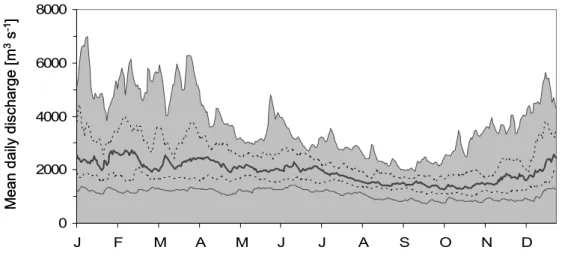
For the River Rhine, modifications and its implications apply to a particular degree, since the Rhine basin is actually one of the densest populated areas in Europe (290 inhabitants per km
2). With a length of 1320 km from its source in the Swiss Alps to its mouth into the North Sea and a drainage area of 185,000 km
2, the Rhine belongs to the largest European rivers. The Lower Rhine section reaches from the northern threshold of the low mountain range, downstream of the city of Cologne, where the river originally took the character of a broad alluvial lowland river, and the border to the Netherlands. A few kilometres downstream of the Dutch boarder the river splits into the branches of the delta Rhine. The mean discharge before entering the Netherlands is 2270 m
3s
-1(Q
min: 790 m
3s
-1; Q
max: 12000 m
3s
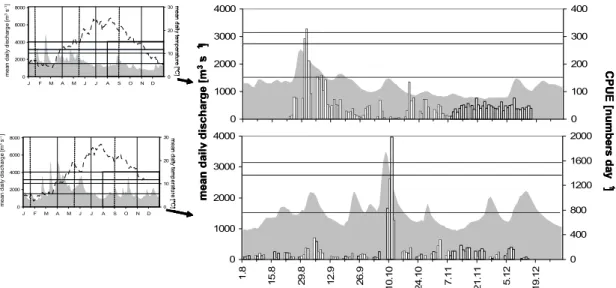
-1). The Lower Rhine receives the majority of its summer discharge from melting ice and snow in the Alps, however, winter discharge is mainly driven by rainfall in the river basin. These preconditions cause a characteristic pluvio-nivale discharge regime with elevated discharges during winter and lowest in late summer and autumn (Quick 2004) (Fig.1). Though single floods may occur at any time of the year, the highest probabilities are given in winter and spring when high precipitation coincides with low evapo-transpiration. Further discharge peaks often occur in early summer, when melting of snow in the Alps reaches its maximum. Under pristine situations single floods endured for several weeks and their amplitude was only a few meters (Nienhuis et al. 2002; Quick 2004).
Fig. 1: Long-term (1955-2005) discharge pattern of the Lower Rhine. (bold solid line:
median; dotted line: quartiles; grey area and thin lower solid line: 99% intervals).
0 2000 4000 6000 8000
J F M A M J J A S O N D
Meandailydischarge[m3s-1]
0 2000 4000 6000 8000
J F M A M J J A S O N D
Meandailydischarge[m3s-1]
From the 14
thcentury onwards the Rhine was subject to intensive direct modifications: closed levees were constructed and hydrological engineering, in terms of meander cuttings, removal of isles situated in the channel and installation of groynes were conducted, in order to maintain the increasingly important becoming navigation even under low discharges (Gelinsky 1951; Hoppe 1970; Lelek 1989;
Tittizer and Krebs 1996; Middelkoop and Van Haselen 1999). These measures led to a massive degradation of in-stream and bank structures and an almost complete loss of the floodplain, which actually accounts for approximately only 15% of its original in the Lower Rhine area (Neumann 2002). The shortening of the Lower Rhine section (approximately 23 km), led to an increase of flow velocity (today 1.0- 2.2 m s
-1in the channel (Engel, Menzel, and Wander 1988). In contrast to many other large temperate rivers (Petts et al. 1989; Buijse et al. 2002), to the Upper Rhine section and almost all of its tributaries, the Lower Rhine is free-flowing and not impounded or regulated by weirs. However, for the Lower Rhine this implies deficits of sediment load and disturbed erosion and sedimentation processes (Tittizer and Krebs 1996; Middelkoop and Van Haselen 1999). Due to the increased current velocity and a prevented lateral erosion, the river became increasingly forced to take material from its own bed, which led to an ongoing incision and deepening of the channel (averagely 1-2 cm year
-1(Dröge, Engel, and Gölz 1992; Bundesministerium für Verkehr 1997). Alone in the period from 1828 to 1920 a lowering of the Rhine bed of 3 m occurred, and an increase of 7 m in recent years stands to expect (Nienhuis et al. 2002). Conversely an increased accretion of sediments occurs at the river banks and particularly in the floodplain, which successively becomes heightened relative to the mean water mark (Middelkoop and Van Haselen 1999;
Neumann 2002). Although the general discharge pattern persisted, the canalisation and the loss of retention resulted in a reduced run-off buffering and rapidly rising peak discharges with high magnitudes, however, a shortening of duration of floods compared to the pristine situation (Fig. 1). The amplitude between high and low water mark has changed from 1.5-2.5 m a 1000 years ago to 7-10 m at present (Nienhuis et al. 2002). Today, the Lower Rhine has become the most important inland waterway in Europe with 500-600 ship passages per day and the river banks are exposed to artificial alternating currents and heavy waves (Pottgiesser et al.
2005). Moreover, parallel to the industrial revolution and population increase, the
Rhine was subject to increasing amounts of untreated sewage effluents. The climax
of highest pollution was reached in the 1960 and 70 years, and the oxygen saturation fell far below the requirements of most aquatic organisms, resulting in a strong decline of fish and invertebrate species, which however recovered from the 1980ies onwards due to the exhaustive implementation of sewage plants. However, many of the invertebrate species currently occurring in the Rhine are immigrants which colonised the Rhine system via the Rhine-Main-Danube channel or have been spread by ships from various regions of the world (Kureck 1992; Bij de Vaate et al. 2002).
Although some pollutants still reach critical levels, the water quality of the Rhine is commonly regarded not to preclude the recovery of the original biocoenosis, whereas the structural deficits resulting from the excessive river modification, by now remained widely untouched.
In addition, the modifications of the Lower Rhine not only imply a habitat degradation of the River channel, but also a disturbed hydrological interaction with its floodplain. Owing to river deepening and a corresponding drawdown of the groundwater table, many natural floodplain waterbodies (oxbows, flood channels, scour pools), are situated vertically far above the rivers recent channel and took a semi-permanent or ephemeral hydrological character due to a decrease of the ground water level. Many of them show a considerable decrease in water level in periods of low discharge or, if not sealed towards the groundwater table, even dry out completely. Almost all waterbodies have a strictly lentic character and current only occurs during extreme floods.
In order to estimate the number and area of waterbodies situated in the recent
floodplain and their hydrological status a GIS-analysis based on aireal pictures from
public OGC-files taken during high and low summer discharge conditions was
conducted. At present a total of 168 permanent and 62 semi-permanent (strong
decrease of lake area during summer, seldom complete desiccation) waterbodies is
present in the area between the winter dykes (total area approximately 290 km
2) in
the Northrhine-Westphalian section of the Lower Rhine, from which 69 are
permanently and 162 only temporarily connected with the river. Almost all
permanently connected waterbodies are former or recent gravel pits (n = 23; area ~
540 ha), former oxbows (n = 7; area ~ 105 ha, which have often been additionally
subject to excavation), industrial harbours and marinas (n = 41, area ~ 650 ha). Most
of these waterbodies are characterised by large depths (up to 25 m), steep banks and
a low shoreline diversity, and riparian or aquatic vegetation is either absent or due to extreme water-level fluctuations situated far above the average water mark (Neumann et al. 1996; Staas and Scharbert 2001; Borcherding and Staas 2008). In contrast, non-permanently connected waterbodies are natural floodplain waterbodies (oxbows, flood channels, scour pools; n = 29: area ~ 210 ha), former refilled or reconstructed gravel-pits (n = 53; area ~ 330 ha) or small, however, with respect to their origin, not clearly distinguishable waterbodies, which result either from geo- morphological processes, coalmining-induced terrain lowering, gravel-mining or borrowing (n = 75; area ~ 31 ha). Categorically, non-permanently connected waterbodies are characterised by a lower average depth, greater shoreline diversity and often abundant riparian and aquatic vegetation (Staas and Scharbert 2001;
Scharbert and Greven 2002).
16
Fig.2a: Map of the Northrhine-Westphalian section of the Lower Rhine between the border to Rhineland-Palatinate (river km 640) and the upstream Düsseldorf (river km 730). The maximally floodable are is given in pale grey. Areas taken by the Rhine and permanently connected waterbodies given in dark grey and these of non-permanently connected waterbodies in black. Hatched areas mark locations where regularly ephemeral waterbodies remain after floods. Waterbody areas refer to average summer discharge conditions. .Rhineland-Palatinate
Cologne
0 69
680 650
660
Bonn
720 710
up W r pe
700
egSi
670
640
Rhineland-PalatinateRhineland-PalatinateRhineland-Palatinate
Cologne
0 69
680
Cologne
0 69
680
Cologne
0 69
680
Cologne
0 69
680 650
660
Bonn
650
660
650
660
Bonn
720 710
720 710
up W r pe
W 700
pe up r
700
egSi
670
egSi
670
640 640
Fig.2b: Map of the Northrhine-Westphalian section of the Lower Rhine between river km 730 and the border to the Netherlands (river km 730). The maxim floodable are is given in pale grey. Areas taken by the Rhine and permanently connected waterbodies are given in dark grey and these of non- permanently connected waterbodies in black. Hatched areas mark locations where regularly ephemeral waterbodies remain after floods. Waterbody refer to average summer discharge conditions.
TheNetherlands
83
0
850
840
790
760 750
Dusseldorf
ft Er
740
Duisburg 730
0 78
077
Ruhr
820
810
80
0
Lippe TheNetherlandsTheNetherlands
83
0
83
0
850
840
850
840
790 790
760 750
760 750
Dusseldorf
ft Er
740
DusseldorfDusseldorf 730
ft Er
740
730
ft Er
740
Duisburg 730
0 78
077
Ruhr
Duisburg
0 78
077
DuisburgDuisburg
0 78
077
Ruhr
820
810
80
0
Lippe
820
810
80
0
820
810
80
0
Lippe
Furthermore there is a considerable number of ephemeral waterbodies situated in the floodplain, which originate from former flood-channels, scour pools or filled gravel- pits, however, their number and area could not be quantified representatively, since their occurrence depends on the strength of the floods and thus varies inter-annually and seasonally.
During average summer discharge conditions the ratio of the area taken by the channel and those of all non-ephemeral stagnant waterbodies is 4:1, and 12:1 regarding non-permanently connected waterbodies. When taking into account only non-ephemeral waterbodies, there is still a quasi-natural gradient of increasing numbers (spearman rank correlation: r
s= 0.868, P < 0.001) and areas of stagnant waterbodies (r
s= 0.873, P < 0.001) in longitudinal direction. This longitudinal pattern was initially, or would even be under potential conditions, determined by the width and the slope of the valley, the granulation of the deposits and the related geo- morphological processes (Quick 2004). Today, this gradient is exclusively determined by the position of the major embankments, the degree of anthropogenic over-forming and the intensity of gravel mining, respectively.
Exploring fish communities in a such highly modified environment offers the opportunity not only to illuminate how these or either single species cope with the strongly altered conditions, but, by identifying patterns along seasonal, spatial and hydrological gradients and related habitat conditions, to determine fundamentals of recruitment and community organisation. The aim of the present thesis is to illuminate whether there are persistent adaptations of species to hydrological patterns and related habitat availability, and which factors influence recruitment patterns and habitat utilisation and, thus, shape fish communities in floodplain waterbodies. For this reason this study focuses mainly on non-permanently connected waterbodies, since these represent the respective gradients.
Chapter 1 explores the significance of seasonal floodplain inundations on recruitment
patterns and spatio-temporal habitat utilisation of species. Hydrology in terms of
seasonal inundations is considered as a crucial factor for fish communities in the
floodplain, since it determines upon exchange mechanisms and involves an
expansion of habitat area and an increase of productivity. Lateral migrations of adult
fishes in order to spawn onto the floodplain probably represent the highest degree of
adaptation. Thus, such species are hypothesised to recruit most successfully when the requirements for placing the progeny under optimal conditions, and lowest recruitment should take place when unfavourable conditions occur. In contrast, reverse adaptations are to expect for species typically inhabiting stagnant and more remote waterbodies, for which inundations might be detrimental, since they involve disturbances. However, little knowledge exists with regard to such adaptations of species in European lowland rivers and, most important, whether these are related to life-history strategies. Furthermore, habitat requirements particularly in YOY fishes vary strongly and some species are characterised by only seasonal floodplain habitat utilisation, whereas other inhabit floodplain lakes more permanently. But again, only little is known about the seasonal aspects and the reasons for such spatio-temporal patterns. Consequently, this study aims on closing these gaps of knowledge, which are considered to be crucial for maintenance of biodiversity and for sustaining of fish populations in riverine wetlands, particularly in the light of ongoing river modifications and possible effects of climatic change.
Hydrology not only determines upon possible exchange patterns of fish between and within different zones of the floodplain, but also controls the availability of physical habitat in space and time. For instance, stagnant floodplain waterbodies situated adjacent to the river often experience excessive changes in habitat availability, e.g.
area draw-downs from the flood peak to the moment of disconnection and seepage in
the course of the isolation phase. In contrast, more stable conditions prevail in
waterbodies less affected by fluctuations of river discharge. Consequently, different
preconditions of recruitment for species exhibiting distinct reproductive strategies
and habitat requirements are to expect. Particularly YOY fish are considered to
exhibit very narrow habitat preferences, which vary between different species and
are often attributed to ontogenetic steps, swimming and feeding capabilities. Thus,
site characteristics in space and time might control survival of YOY fishes with
different requirements. Therefore, this second part of the study (Chapter 2) aims on
illuminating the significance of seasonally varying habitat availability in front of
species-specific habitat requirements and other determinants of survival in YOY fish,
like predator abundance, growth performance and size, as well as density-dependent
implications.
Species-specific temperature requirements for spawning in fishes and their reproductive adaptation towards predictable discharge patterns are expected to provide their progeny with benefits associated to optimal energy gain and related growth performance. It is commonly argued that early spawning species are advantaged over later spawners, since they attain a relative larger size, higher motility and forage more efficiently. This particularly applies to piscivorous species, however, the onset of piscivory in YOY fish is known to depend on further determinants, such as prey availability to maintain a size advantage over extended periods in the first year of life. Both abundant planktonic organisms serving as initial prey as well as small fish larvae being available for extended periods should enhance YOY piscivory. However, little is known about the determinants and the implications of early piscivory in European river floodplains. Consequently, the third part of this study (Chapter 3) aims on the identification of the causes for early piscivory in two functionally different piscivorous fish species, as well as its consequences for their potential prey fish populations in front of hydrological and habitat parameters.
Since all topics of the present work deal with differences of abundance of species in
space and time, a modified sampling approach was used to compare data gathered
over several habitat scales, which is documented in appendix chapter 1.
References
Admiraal W, Breebaart L, Tubbing GMJ, Van Zanten B, De Ruyter van Steveninck ED, Bijkerk R. (1994) Seasonal variation in composition and production of planktonic communities in the lower river rhine. Freshwater Biology, 32, 519- 531.
Amoros C, Roux AL. (1988) Interaction between water bodies within the floodplains of large rivers: Function and development of connectivity. Schreiber, K.-F.
Connectivity in Landscape Ecology, Proceedings of the 2nd International Seminar of the International Association of Landscape Ecology. Münstersche Geographische Arbeiten 29, 125-130
Antipa G. (1910) Das Überschwemmungsgebiet der unteren Donau. Anuarul Institutului Geologieal Romînei, 4, 225-496.
Antipa G. (1923) Die biologischen Grundlagen und der Mechanismus der Fischproduktion in den Gewässern der unteren Donau. Academie Roumaine, Bulletin de la Section Scientifique, 11, 1-20.
Balon EK. (1963) Einige Fragen über das Vorkommen und Biomasse der Fische in Inundationsseen und im Hauptstrom der Donau in der Zeit des niedrigen Wasserstandes. Zoologischer Anzeiger, 171, 415-423.
Balon EK. (1966) Bemerkungen über die Fischgemeinschaften und über die Ichthyomasse eines Inundationsarmes der Donau. Verhandlungen der Internationalen Vereinigung für Limnologie, 16, 1108-1115.
Baranyi C, Hein T, Holarek C, Keckeis S, Schiemer F. (2002) Zooplankton biomass and community structure in a Danube River floodplain system: effects of hydrology. Freshwater Biology, 47, 473-482.
Bayley PB. (1991) The flood pulse advantage and the restoration of river-floodplain systems. Regulated rivers: Research & Management, 6, 75-86.
Bayley PB. (1995) Understanding large river-floodplain ecosystems. BioScience, 45, 153-158.
Bij de Vaate A, Jazdzewski K, Ketelaars HAM, Gollasch S, Van der Velde G. (2002) Geographical patterns in range extension of Ponto-Caspian macroinvertebrate species in Europe. Canadian Journal of Fisheries and Aquatic Sciences, 59, 1159-1174.
Böcking W. (1982) So fischte man am Niederrhein, -338, Boss Verlag, Kleve.
Borcherding J, Staas S. (2008) Local riverine fish communities as promoters for habitat restoration in the floodplain area of the lower Rhine. Reconciling Fisheries with Conservation, Vols I and II. 4th World Fisheries Congress.
American Fisheries Society Symposium 49, 835-848.
Buijse AD, Coops H, Staras M, Jans LH, Van Geest GJ, Grift RE, Ibelings BW, Oosterberg W, Roozen FCJM. (2002) Restoration strategies for river floodplains along large lowland rivers in Europe. Freshwater Biology, 47, 889-907.
Bundesministerium für Verkehr. (1997) Sohlengleichgewicht am Rhein.
Bestandsaufnahme und Maßnahmenprogramm. Bericht der Arbeitsgruppe
"Rheinsohlenerosion".Münster, Mainz.
Copp GH. (1989) The habitat diversity and fish reproductive function of floodplain
Cowx IG, Welcomme RL. (1998) Rehabilitation of rivers for fish, Fishing New Books, Oxford.
De Groot SJ. (2002) A review of the past and present status of anadromous fish species in the Netherlands: is restocking the Rhine feasible? Hydrobiologia, 478, 205-218.
Dröge B, Engel H, Gölz E. (1992) Channel erosion and erosion monitoring along the Rhine River. IAHS Publications, 210, 493-503.
Dynesius M, Nilsson C. (1994) Fragmentation and flow regulation of river systems in the Northern third of the World. Science, 266, 753-762.
Engel H, Menzel T, Wander K. (1988) Fließzeiten im Rhein aus Wasserspiegelberechnungen. In: BfG-0429, Anlagen, Koblenz.
Freeman MC, Bowen ZH, Bovee KD, Irvin ER. (2007) Flow and Habitat Effects on Juvenile Fish Abundance in Natural and Altered Flow Regimes. Ecological Applications, 11, 179-190.
Gelinsky P. (1951) Ausbau des Rheins vom Main bis zur niederländischen Grenze.
In: Der Rhein - Ausbau, Verkehr, Verwaltung, 147-206, Duisburg.
Gutreuter S, Bartels AD, Irons K, Sandheinrich MB. (1999) Evaluation of the flood- pulse concept based on statistical models of growth of selected fishes of the Upper Mississippi River system. Canadian Journal of Fisheries and Aquatic Sciences, 56, 2282-2291.
Hein T, Baranyi C, Heiler G, Holarek C, Riedler P, Schiemer F. (1999) Hydrology as a major factor determining plankton development in two floodplain segments and the River Danube, Austria. Archiv für Hydrobiologie Supplementband Large Rivers Vol. 11, 115, 439-452.
Holcik J, Bastl I. (1976) Ecological effects of water level fluctuations upon the fish populations in the Danube River floodplain in Czechoslovakia. Acta Sc.Nat.Brno, 10, 1-46.
Hoppe C. (1970) Die großen Flussverlagerungen des Niederrheins in den letzten zweitausend Jahren und ihre Auswirkungen auf Lage und Entwicklung der Siedlungen, Forschung deutscher Landeskunde, Bd 189, Bonn.
Humphries P, King AJ, Koehn JD. (1999) Fish, Flows and Flood Plains: Links between Freshwater Fishes and their Environment in the Murray-Darling River System, Australia. Environmental Biology of Fishes, 56, 129-151.
Iksr. (1999) 2. Internationales Rhein-Symposium "Lachs 2000" - Tagungsband, -311, Koblenz.
Jungwirth M, Muhar S, Schmutz S. (2000) Fundamentals of fish ecological integrity and their relation to the extended serial discontinuity concept. Hydrobiologia, 422, 85-97.
Jungwirth M, Muhar S, Schmutz S. (2002) Re-establishing and assessing ecological integrity in riverine landscapes. Freshwater Biology, 47, 867-887.
Junk WJ. (1999) The floodpulse concept of large rivers: learning from the tropics.
Archiv für Hydrobiologie Supplementband Large Rivers Vol. 11, 115, 261-280.
Junk WJ, Bayley PB, Sparks RE. (1989) The flood pulse concept in river-floodplain systems. In: Proceedings of the international large rivers symposium, 110-127, Canadian Special Publications of Fisheries and Aquatic Sciences 106.
Keckeis S, Baranyi C, Hein T, Holarek C, Riedler P, Schiemer F. (2003) The significance of zooplankton grazing in a floodplain system of the River Danube.
Journal of Plankton Research, 25, 243-253.
Kern K. (1994) Grundlagen naturnaher Gewässergestaltung - Geomorphologische Entwicklung von Fließgewässern, Springer, Berlin.
King AJ, Humphries P, Lake PS. (2003) Fish recruitment on floodplains: the roles of patterns of flooding and life history characteristics. Canadian Journal of Fisheries and Aquatic Sciences, 60, 773-786.
Kureck A. (1992) Neue Tiere im Rhein - Die Wiederbesiedlung des Stroms und die Ausbreitung der Neozoen. Naturwissenschaften, 79, 533-540.
Lelek A. (1987) The Freshwater Fishes of Europe - Threatened Fishes of Europe, AULA Verlag, Wiesbaden.
Lelek A. (1989) The Rhine River and some of its tributaries under human impact in the last two centuries. In: Proceedings of the International Large River Symposium, 469-487, Canadian Special Publications of Fisheries and Aquatic Sciences 106.
Lytle DA, Poff L. (2004) Adaptation to natural flow regimes. Trends in Ecology &
Evolution, 19, 94-100.
Middelkoop H, Van Haselen COG. (1999) Twice a river: Rhine and Meuse in the Netherlands. RIZA Institute for inland water management and waste water treatment, Arnhem.
Muhar S, Schwarz M, Schmutz S, Jungwirth M. (2000) Identification of rivers with high and good habitat quality: methodological approach and applications in Austria. Hydrobiologia, 422, 343-358.
Neumann D. (2002) Ecological rehabilitation of a degraded large river system - Considerations based on case studies of macrozoobenthos and fish in the Lower Rhine and its catchment area. International Review of Hydrobiology, 87, 139- 150.
Neumann D, Staas S, Molls F, Seidenberg-Busse C, Petermeier A, Rutschke J.
(1996) The significance of man-made lentic waters for the ecology of the Lower River Rhine, especially for the recruitment of potamal fish. Archiv für Hydrobiologie Supplementband, 113, 267-278.
Nienhuis PH, Buijse AD, Leuven RSEW, Smits AJM, de Nooij RJW, Samborska EM. (2002) Ecological rehabilitation of the lowland basin of the river Rhine (NW Europe). Hydrobiologia, 478, 53-72.
Petts GE, Möller H, Roux AL. (1989) Historical change of large alluvial rivers, John Wiley & Sons Ltd, Chicester.
Pottgiesser T, Ehlert T, Frenz C, Friedrich G, Halle M, Lorenz A, Scharbert A, Van
de Weyer K. (2005) Biozönotische Leitbilder und das höchste ökologische
Potenzial für Rhein und Weser in Nordrhein-Westfalen. LUA-Merkblätter 49,
Eigenverlag Landesumweltamt Nordrhein-Westfalen, Essen.
Quick I. (2004) Geomorphologisches Leitbild des Niederrheins - Methodik zur Leitbildentwicklung für Ströme in Hinblick auf die Gewässerstrukturgütebewertung, Ferger Verlag, Bergisch Gladbach.
Rosenfeld JS, Hatfield T. (2006) Information needs for assessing critical habitat of freshwater fish. Canadian Journal of Fisheries and Aquatic Sciences, 63, 683- 698.
Scharbert A, Greven H. (2002) Umgestaltete Abgrabungsseen: Auengewässer der Zukunft? Verhandlungen der Gesellschaft für Ichthyologie, 3, 131-187.
Schiemer F, Keckeis H, Winkler G, Flore L. (2001) Large rivers: the relevance of ecotonal structure and hydrological properties for the fish fauna. Archiv für Hydrobiologie Supplementband - Large Rivers 12, 135, 487-508.
Schiemer F, Spindler T, Wintersberger H, Schneider A., Chovanec A. (1991) Fish fry associations: Important indicators for the ecological status of large rivers.
Verhandlungen der Internationalen Vereinigung für Limnologie, 24, 2497-2500.
Schiemer F, Waidbacher H. (1992) Strategies for conservation of a Danubian fish fauna. River Conservation and Management, 23, 364-382.
Schiemer F, Zalewski M. (1992) The importance of riparian ecotones for diversity and productivity of riverine fish communities. Netherlands Journal of Zoology, 42, 323-335.
Schlosser IJ. (1998) Fish recruitment, dispersal, and trophic interactions in a heterogeneous lotic environment. Oecologia, 113, 260-268.
Schlosser IJ. (1991) Stream fish ecology: a landscape perspective. BioScience, 41, 704-712.
Shiel RJ, Green JD, Nielsen DL. (1998) Floodplain biodiversity: why are there so many species? Hydrobiologia, 388, 39-46.
Sparks RE, Bayley PB, Kohler SL, Osborne LL. (1990) Disturbance and recovery of large floodplain rivers. Environmental Management, 14, 699-709.
Sparks RE, Nelson JC, Yin Y. (1998) Naturalisation of the flood regime in regulated rivers. BioScience, 48, 706-720.
Staas S, Scharbert A. (2001) Gutachten zur Erfassung von Seitengewässern entlang des nordrhein-westfälischen Rheinabschnittes aus fischökologischer Sicht, Unveröffentlichte Studie im Auftrag der Rheinfischereigenossenschaft, Nörvenich.
Stankovic S, Jankovic D. (1971) Mechanismus der Fischproduktion im Gebiet des mittleren Donaulaufs. Archiv für Hydrobiologie Supplementband Donauforschung, 36, 299-305.
Tittizer T, Krebs F. (1996) Ökosystemforschung: Der Rhein und seine Auen - eine Bilanz, Springer, Berlin, New York.
Tockner K, Baumgartner C, Schiemer F, Ward JV. (2000) Biodiversity of a Danubian floodplain: structional, functional and compositional aspects. In:
Biodiversity in Wetlands: Assessment, Function and Conservation., 141-159, Backhuys Publishers, Leiden, the Netherlands.
Tockner K, Malard F, Ward JV. (2000) An extension of the flood pulse concept.
Hydrological Processes, 14, 2861-2883.
Tockner K, Pennetzdorfer D, Reiner N, Schiemer F, Ward JV. (1999) Hydrological connectivity, and the exchange of organic matter and nutrients in a dynamic river-floodplain system (Danube, Austria). Freshwater Biology, 41, 521-535.
Ward JV. (1989) The four-dimensional nature of lotic ecosystems. Journal of the North American Benthological Society, 8, 2-8.
Ward JV. (1998) Riverine landscapes: biodiversity patterns, disturbance regimes, and aquatic conservation. Biological Conservation, 83, 269-278.
Ward JV, Stanford JA. (1995) The serial discontinuity concept: Extending the model to floodplain rivers. Regulated rivers: Research & Management, 10, 159-168.
Ward JV, Tockner K, Arscott DB, Claret C. (2002) Riverine landscape diversity.
Freshwater Biology, 47, 517-539.
Winemiller KO. (2004) Floodplain river foodwebs: generalizations and implications for fisheries management. Welcomme, R. L. and Petr, T. Sustaining livelihoods and biodiversity in the new millennium: Proceedings of the second international symposium on the management of larve rivers for fisheries (Volume II). RAP Publication 17, 285-310.
Winemiller KO, Rose KA. (1992) Patterns of life-history diversification in North American fishes: implications for population regulation. Canadian Journal of Fisheries and Aquatic Sciences, 49, 2196-2218.
Woodward G, Hildrew AG. (2002) Food web structure in riverine landscapes.
Freshwater Biology, 47, 777-798.
Zeug SC, Winemiller KO. (2007) Ecological correlates of fish reproductive activity
in floodplain rivers: a life-history-based approach. Canadian Journal of Fisheries
and Aquatic Sciences, 64, 1291-1301.
Relationships of hydrology and life-history strategies on spatio- temporal habitat utilisation of fish in European temperate river
floodplains
Abstract
Floodplain inundation is considered as crucial for recruitment of fish in lowland rivers, by either providing suitable spawning areas as well as breeding habitats for young-of-the-year fish (YOY), or supporting species that exhibit different life history-strategies to be differently adapted to long term discharge patterns. Fish communities in a set of 38 waterbodies in the Lower Rhine floodplain, representing different long-term frequencies of inundation and differently affected by seasonal inundations, were sampled with electrofishing (Point abundance sampling, total n = 42,701 points) over a four-year period in order to identify species-specific and life- history strategy related patterns of spatio-temporal floodplain habitat utilisation. For 18 species (total catch: n = 107,150), typically occurring in European lowland rivers and representing different ecological guilds, different responses towards seasonal inundations were found. YOY of most species closely associated to the periodic strategy (e.g., Abramis brama, Aspius aspius, Blicca bjoerkna) were highly abundant in frequently inundated waterbodies, as long as these were subject to inundations occurring in spring and early summer and coincided with required temperatures for spawning. However, recruitment in these species was impaired or even failed when no inundations in this time frame occurred, although adults were present. In contrast, most species associated to the opportunistic strategy (e.g., Gasterosteus aculeatus, Pseudorasbora parva, Leucaspius delineatus) had highest recruitment in waterbodies unaffected by inundations in this time frame, which had detrimental effects on these predominantly small sized species. Spatio-temporal floodplain habitat utilisation of YOY fish (most rheophilic species as well as eurytopics like Abramis brama, Cyprinus carpio and Sander lucioperca) is suggested to be size-related, since most fast growing periodic strategists left the floodplain at given connectivity at latest in winter and were then absent in the subsequent year. Smaller YOY fishes and all opportunistic species remained in more isolated waterbodies, from which they dispersed across the floodplain to some degree during extensive winter floods. These findings suggest adaptations to the long-term hydrograph of large river systems, with flood-related recruitment patterns predominantly occurring in periodic strategists and low-flow recruitment strategies in opportunistic strategists and stagnophilic species.
The results of this study point to the significance of hydrological transversal
floodplain gradients for providing diverse communities and population maintenance
of different life-history strategies under a variety of hydrograph scenarios.
Introduction
The significance of floodplain inundation for fish production in temperate lowland rivers as well as seasonally differing species compositions between the river channel and floodplain lakes have been early recognized (Antipa 1923; Balon 1963; Holcik 1988) and similar relationships haven been demonstrated to occur in further biota (Hein and Heiler 1999; Baranyi et al. 2002; Van Geest et al. 2003). Though originally conceived to tropic systems, the ecological implications of seasonal floodplain inundation are well displayed in the conceptual frame-work of the flood- pulse-concept (FPC) (Junk, Bayley, and Sparks 1989), pronouncing that flood events in lowland rivers act as disturbances, by facilitating aquatic organisms access to different habitats, by nutrient and matter exchange and by structuring the habitats within the aquatic-terrestrial transition zone. The interactions of these factors are addressed to cause the high overall productivity and diversity of floodplain systems.
The periodicity of inundations implies a transition from more physically (flow, temperature, water quality, habitat complexity) driven systems during the connection phase to more biologically (competition, predation) driven systems during the isolation phase (Bayley 1991; Ward and Stanford 1995; Junk 1999).
In rivers with predictable flow regimes, individual fish species are believed to have evolved different strategies to maintain their populations, e.g. by synchronizing their reproduction with flood events that coincide with optimum temperatures for spawning in order to place their offspring in the floodplain, where it can benefit from the high productivity associated with the aquatic-terrestrial transition zone (Junk et al. 1989). This synchronisation might either function by stimulating spawning of adults within the floodplain directly, or by spawning outside the floodplain but providing larvae and juvenile access to the flooded habitats (Schiemer et al. 2001).
However, with regard to temperate systems, it is suggested that recruitment of species that are highly adapted to reproduction within the floodplain is impaired, when floods fail to appear, retreat too quickly or do not coincide with appropriate temperatures (Bayley 1991). In contrast, recruitment of species that exhibit alternative reproductive strategies might be supported under low flow conditions (Humphries, King, and Koehn 1999).
Hence annual hydrological conditions are expected to affect reproduction and
recruitment of species with different life-history strategies differently. Winemiller
and Rose (1992) demonstrated that these adaptations are strongly correlated with
other species-specific life-history traits, such as longevity, age and size at maturity and growth performance and proposed species to be arranged within a triangular continuum, which endpoints represent the three major life-history strategies. When linking the tenets of the FPC with that of life-history theory, species that synchronize their reproduction with optimal discharge and temperature conditions should predominantly belong to the group of periodic strategists, which delay maturity until they are large enough to produce large numbers of small eggs which are placed under appropriate, but often short-lasting conditions (Winemiller and Rose 1992). Species that are less adapted towards predictable flow regimes are often characterised by an attainment of maturity at small lengths and young age, protracted spawning periods with multiple spawning bouts, which enables them to maintain their population even under unfavourable conditions and to compensate an increased adult mortality, which are typical features of opportunistic strategists and favours these species to colonize new habitats quickly (Winemiller and Rose 1992). Though this scheme was initially conceived to the North American fishfauna, it has been extended to a range of species typically inhabiting European freshwaters (Vila-Gispert and Moreno-Amich 2002; Blanck, Tedesco, and Lamouroux 2007). However, until now no attempts have been undertaken to investigate the relationships of species exhibiting different life- history strategies and their habitat utilization in European temperate river floodplains.
Taking into account the four-dimensional nature of alluvial floodplain rivers and the instability of habitat conditions in space and time (Ward 1998; Junk 1999), it is hypothesized that the community organisation within the different patches of the floodplain results from different species-, stage- and life-history strategy-specific adaptations towards a) the disturbances caused by inundations, b) the changing habitat conditions and c) the interactions of biota (food availability, predation).
Depending on the seasonality of inundations and the connectivity of habitats within the floodplain, species life-stages are thus considered to form spatially and temporarily distinct communities in patches. With respect to young-of-the-year (YOY) fish assemblages it has indeed been demonstrated that communities change along a lateral, i.e. hydrological gradient as a consequence of spatially distinct reproduction and nursery zones (Copp 1989).
Schiemer and Waidbacher (1992) classified European fish species into ecological
guilds according to the presence of their life-stages in characteristic assemblages in
channel and differently connected floodplain habitats of the Danube River. However, only little information exists with regard to the seasonal aspects and the causes of laterally directed exchange processes and their significance for population maintenance. Hence, our knowledge of spatio-temporal dynamics and the species- and stage-related adaptation towards seasonal floodplain inundation in temperate European rivers remains limited. Furthermore, today most of the temperate lowland rivers are heavily altered by human activities, including massive losses of floodplain area and reduced habitat diversity, as well as modified hydroperiods (Buijse et al.
2002) and it is not sufficiently known how the different species cope with these changed conditions.
In this study we analyse data gathered in a four-year study from a large set of
floodplain waterbodies of different degree of connectivity, origin, hydrological
character and spatial distance to the river in front of inter-annually and seasonally
varying inundation patterns, in order to estimate the relative importance of seasonal
inundations on fish communities and recruitment patterns of species representing
different life-history strategies. We aim to determine which species typically
inhabiting large European river floodplains have adapted their life-cycle to long-term
discharge patterns and how they are affected by deviations from this scheme. We
analyse how seasonal floodplain habitat utilisation of species life-time stages in a
modified river floodplain responds to seasonal inundations and whether these
patterns could be related to life-history strategies. This knowledge is of importance
for sustaining population maintenance in the light of still proceeding modifications of
river-floodplain interactions or probably occurring in the course of climate change.
Methods Study site
With a length of 1320 km from its source in the Swiss Alps to its mouth into the North Sea and a drainage area of 185,000 km
2, the Rhine is one of the largest rivers in Europe. In contrast to all of his tributaries and most other large temperate rivers in the world, the longest part of the Rhine is free flowing and not regulated by dams.
The present study was conducted at the Lower Rhine area within the boarders of the German federal state North Rhine-Westphalia. The river section reaches from the northern threshold of the low mountain range downstream of the city of Cologne and the border to the Netherlands. The mean discharge before entering the Netherlands is 2270 m
3s
-1(mean low-water discharge: 1030 m
3s
-1; mean-high water discharge:
6550 m
3s
-1). The Lower Rhine receives the majority of its summer discharge from melting ice and snow in the Alps, however, winter discharge is mainly driven by rainfall in the river basin. In the pristine situation these preconditions caused a characteristic temperate-seasonal discharge regime with often long enduring floods occurring from late winter until the beginning of summer and lowest discharges in late summer and autumn (Quick 2004).
Straightening and reinforcement in order to protect the densely populated hinterland and agricultural areas from floods caused a massive loss of the floodplain area initially available. Since the Lower Rhine has become the most important inland waterway in Europe with 500-600 ship passages day
-1, groynes have been constructed, in order to maintain navigation even under low discharges. Owing to these modifications, the flow velocity within the channel increased considerably (mean 1.5 m s
-1) which led to an irreversible and still preceding erosive incision of the river channel (mean 2 cm year
-1). Furthermore, the canalization and the loss of retention area in the whole basin causes rapidly rising peak discharges with high magnitudes, but a reduced duration of floods and strongly fluctuating water levels even at moderate discharges.
Most of the waterbodies within the active floodplain (in terms of the maximum
floodable area between the winter-dykes) of the German stretch originate from gravel
mining, of which the majority was partly refilled with allochtonous material and
disconnected from the river after excavation.
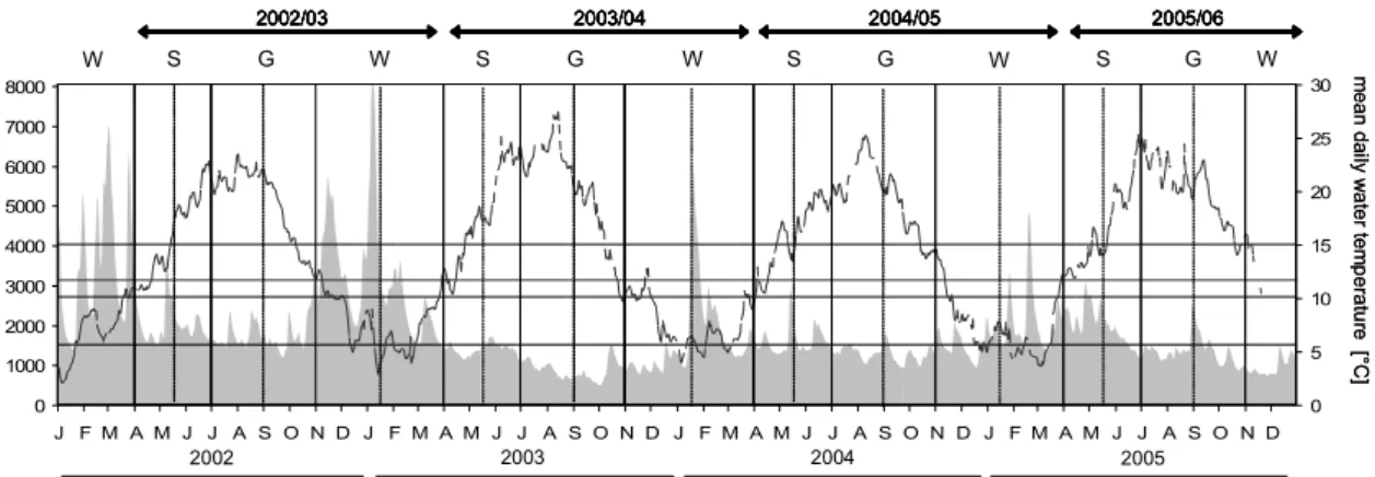
Fig. 1 (previous page): Map with location of the area of investigation and the sampled waterbodies (black) in the Lower River Rhines floodplain (pale grey area). Arrow in Figure 1e denotes the location of the anchored stow-net. Numbers of waterbodies increase with descending long-term degree of connectivity (see Table 1).
Table 1: Characteristics of the waterbodies situated the Lower Rhine’s floodplain and the sampling scheme in the annual cycles between the May of 2002 and the November of 2005. Waterbodies are sorted after their degree of connectivity. Numbers refer to whether sampling was conducted in the first (1) and/or the second (2) half of the respective period (S = spawning, G = growth, W = winter; compare Figure 1 for definitions). Asterisks denote more than one sampling date per sub-period. † = waterbody was initially permanently connected to the channel and disconnected in August 2003 after sampling was conducted. The total of sampled waterbodies and the sampling effort (sum of point-samples) per period are given below.
S G W S G W S G W S G W
1 oxbow 0 365 0.54 perennial 1/2 1 1/2 1*/2 1/2* 2 1/2 1/2
2 oxbow 0 365 1.90 perennial 2 2 1 2 1/2* 1*/2 1/2 1/2 1/2*
3 oxbow 0.21 237 0.77 semi-perennial 2 2 1/2* 2 1 2
4 scour pool 0.01 190 0.79 perennial 2 2 2 2 1/2 2
5 former gravel-pit 0.03 186 6.89 perennial 2 2 2 1/2 1/2 2 1/2*
6 oxbow 0.05 154 18.77 perennial 2 1/2 2 2 1/2 1/2* 1 1/2 1/2
7 former gravel-pit 0.09 132 18.90 perennial 1† 1 2 1/2* 1 1
8 oxbow 0.61 131 0.74 ephemeral 2 2 1*/2 1*
9 oxbow 1.15 114 1.18 semi-perennial 2 2 2 1/2 1/2 1/2 1/2
10 former gravel-pit 0.09 111 2.67 perennial 2 1 1/2 2* 1/2* 1/2 1/2 1/2
11 former gravel-pit 0.03 108 6.50 perennial 2 1 1/2 2 1/2 1 2 1/2
12 former gravel-pit 0.71 103 0.21 perennial 2 1/2* 2 1
13 former gravel-pit 0.95 98 0.12 perennial 2 1/2 2* 1
14 scour pool 0.09 82 1.74 perennial 2 2 2
15 former gravel-pit 6.00 67 1.61 perennial 1* 2 2 1*/2 1/2 1/2
16 flood channel 0.03 67 0.23 semi-perennial 2 2 2 2 2
17 closed groynefield 0.03 67 1.42 perennial 2 2 2 2 1/2 2 1/2
18 former gravel-pit 0.16 59 1.84 semi-perennial 2 2 2 2 1/2 1/2 2 1/2
19 scour pool 0.14 55 1.85 semi-perennial 2 2 1 2 1 1/2 2 2 2
20 former gravel-pit 0.06 55 1.18 perennial 2 2 2 2 1/2 2 1/2
21 flood channel 0.19 51 6.50 ephemeral 2 2 2 2
22 flood channel 2.17 48 0.17 semi-perennial 1/2 2 1/2 2 2
23 scour pool 0.25 45 0.56 ephemeral 2 2 2
24 flood channel 0.20 43 3.17 perennial 2 2 2 1/2 2 2
25 flood channel 2.32 43 0.12 semi-perennial 1 2 1/2 1 2 2 2
26 flood channel 0.34 36 0.91 semi-perennial 1/2 2 1 2 2 2
27 scour pool 0.58 35 0.44 ephemeral 2 2 2
28 filled gravel-pit 0.11 34 1.91 ephemeral 1 2 1/2 2
29 filled gravel-pit 3.14 34 1.18 perennial 2 1/2 2 2 2 1/2 1/2 2 1/2
30 flood channel 1.29 33 1.07 semi-perennial 1 1/2 1 2 2 2
31 flood channel 1.69 33 0.55 ephemeral 2 2 2 2
32 flood channel 1.14 30 0.35 ephemeral 2 2 2
33 filled gravel-pit 0.04 23 2.55 perennial 2 2 2 2 1/2 1/2 1
34 scour pool 0.57 20 0.87 ephemeral 1/2 2
35 scour pool 0.04 12 0.17 perennial 2 2 2 2 1/2 2 1/2
36 flood channel 0.17 11 0.95 ephemeral 1 2 2 2
37 former gravel-pit 6.80 6 3.34 perennial 2 1/2 2 1/2 2 2
38 flood channel 0.30 5 0.14 semi-perennial 1 2 2 2
No.waterbodies sampled 12 4 31 2 22 38 21 23 26 19 22 1
No. inundated per period 10 2 31 1 0 38 13 5 24 14 7 0
No. samples 1565 570 5547 427 3137 9262 4340 6438 4755 1868 4482 310
2002/03 2003/04 2004/05 2005/06
area (ha) hydrological character No.of
waterbody origin
distance from river
(km)
days inundated
(50 year mean)