Research Collection
Journal Article
Why should I use a multi-hazard app? Assessing the public's information needs and app feature preferences in a participatory process
Author(s):
Dallo, Irina; Marti, Michèle Publication Date:
2021-04-15 Permanent Link:
https://doi.org/10.3929/ethz-b-000477428
Originally published in:
International Journal of Disaster Risk Reduction 57, http://doi.org/10.1016/j.ijdrr.2021.102197
Rights / License:
Creative Commons Attribution 4.0 International
This page was generated automatically upon download from the ETH Zurich Research Collection. For more
information please consult the Terms of use.
International Journal of Disaster Risk Reduction 57 (2021) 102197
Available online 18 March 2021
2212-4209/© 2021 The Authors. Published by Elsevier Ltd. This is an open access article under the CC BY license (http://creativecommons.org/licenses/by/4.0/).
Why should I use a multi-hazard app? Assessing the public ’ s information needs and app feature preferences in a participatory process
Irina Dallo
a,*, Mich ` ele Marti
baETH Zurich, Swiss Seismological Service & D-USYS TdLab, Zurich, Switzerland
bETH Zurich, Swiss Seismological Service, Zurich, Switzerland
A R T I C L E I N F O Keywords:
User needs
App content and features Multi-hazard apps Virtual interactive workshops
A B S T R A C T
In the age of nearly instant information and high-bandwidth communication, public expectations regarding the availability of authoritative short-term and real-time hazard information are evolving rapidly. Despite the ex- istence of numerous apps covering hazard information, little research has been conducted to assess what the public actually expects from such an app. Perceived usefulness is crucial as the public will only use apps offering an added value to them. Several studies have identified that people prefer an app combining relevant hazards instead of single hazard apps. Therefore, we focused our analysis on multi-hazard apps. With seven virtual interactive workshops, we assessed the public’s information needs and app feature preferences. With respect to the content of multi-hazard apps, our results show that participants would mainly combine natural hazards but also have an interest in integrating anthropogenic and socio-natural hazards. To this end, participants advocate sending push notifications for low-probability hazards via general-purpose apps (e.g., weather apps) to reach a larger audience. Despite the desired diversity of hazard information, participants wish for an app focusing on relevant information only and redirecting users to other authorized sources for further information. Participants define the following as relevant information: location, time, hazard severity, behavioral recommendations and the contact details of emergency services. In addition, they wish for the following features: push notifications, a help button, a sharing function, a chat forum, an “I am safe” button, and a “Report an event” button.
1. Introduction
Over recent decades, high-bandwidth communication and the number of people using devices with permanent Internet access have increased rapidly [1,2]. This is one of the reasons why the public expects information about hazards to be available at all times, preferably in real time [1]. Online platforms (e.g., apps, social media) thus have become crucial parts of crisis communication [3,4]. In particular, apps have become frequently used warning and disaster communication means [5]
because they facilitate informing and warning the people who are actually affected by a hazard and because most of the time people have their smartphones with them [6]. During Hurricane Katrina in 2005, researchers recognized for the first time an establishment of online fo- rums for disaster response [7]. Further examples are the earthquake in Haiti in 2010, the terror attack in Paris in 2015 [8], the earthquake in Nepal in 2015 [9], and the earthquake sequence in Mayotte in 2020 [10].
Within the last decade, various hazard apps have been developed,
ranging from awareness apps to warning apps to disaster apps [11,12].
These apps either focus on a single hazard or combine information about different hazards. Increasingly, app users not only receive information but also provide information as in-situ observers [5,13]. In consequence, interaction between the authorities operating apps and its users is becoming increasingly more important. On one hand, such interactions allow authorities to effectively collect more detailed information on local circumstances, such as infrastructure damages, from users [14]. On the other hand, users have the chance to support risk mitigation by taking (precautionary) actions [15].
When developing hazard apps, considering and exploring users’
needs is equally important as technical features because no one will download an app without an apparent added value for him/herself. Thus far, studies have revealed that people appreciate having a chat forum for organizing help as well as to be provided with behavioral recommen- dations and to receive warnings and all-clear notifications [12]. More- over, end-users appreciate if they can personalize the app content, can access the contact details of emergency services, and have the
* Corresponding author. ETH Zurich, Swiss Seismological Service, Sonneggstrasse 5, 8093 Zurich, Switzerland.
E-mail address: irina.dallo@usys.ethz.ch (I. Dallo).
Contents lists available at ScienceDirect
International Journal of Disaster Risk Reduction
journal homepage: http://www.elsevier.com/locate/ijdrr
https://doi.org/10.1016/j.ijdrr.2021.102197
Received 11 November 2020; Received in revised form 18 February 2021; Accepted 14 March 2021
opportunity to give feedback [16]. Furthermore, during and after, for example, a major flood event, people ask for information about medical health (e.g., hospital lists), temporary shelters, a live ticker (e.g., map with the affected area), damages (e.g., severity of the disaster, number of deaths), and food-supplies [17].
The actual design and implementation of such an app is not trivial for various reasons. First, the public’s information needs change across the hazard cycle and thus the authorities have to provide the right infor- mation at the right time [16,18]. Second, due to the fact that informa- tion is spread via multiple channels (e.g., websites, apps, social media), the authorities have to ensure that consistent information is being disseminated [19]. Third, the people affected have to trust in the noti- fications/information they receive, otherwise they will not take any necessary actions [14,20]. It is best if the information comes from (local) federal authorities, which allows people to assign credibility and trust to the information received [18,21]. Fourth, even though many apps already provide behavioral recommendations, people tend to seek additional information before taking any protective actions [22]. Fifth, the implementation of more interactive features to facilitate the communication between the users and the responsible authorities de- mands additional human and financial resources and new skills [23,24].
Lastly, the heterogeneity of users with different needs must be taken into account [25,26].
Thus far, studies have mainly focused on the quantitative analysis of apps’ contents [27,28] and the technical capabilities regarding the implementation of apps [2,29]. Further research is needed to assess users’ requirements in order to identify preferred features [16], how these features should function [12], and whether interactive informa- tion and communication are appreciated [30]. Additionally, we know little about whether people would prefer a specific emergency app or whether, for example, a general-purpose app (e.g., weather app, news app, public transportation app) should be expanded with additional functionalities [5]. Neither have we much knowledge about the infor- mation actually needed on such general-purpose apps.
We thus conducted a case study in Switzerland contributing to filling this research gap by assessing the public’s preferences and needs for information and features on an (multi-hazard) app. In contrast to recent studies that have assessed user needs through interviews, app store comments, or surveys [31,32], we conducted virtual workshops based on the method of user-driven prototyping. User-driven prototyping has the advantage to capture users’ thinking and to reveal user needs that developers may not have thought of by letting them come up with the ideas [33]. This is in contrast to surveys, where researchers often test their own ideas (e.g., different warning messages) and participants tend to check all options because they all sound useful. Alternatively, analyzing comments in app stores, has the disadvantage of only capturing users’ perception of existing apps. To overcome this challenge, we let the participants themselves design low-fidelity prototypes because we did not wanted them to be biased by predefined prototype elements. Additionally, the discussions during the workshops enabled participants to build upon each other’s ideas and to highlight their re- flections [34,35]. We organized the virtual workshops in such a way that the participants had different spaces through which to voice and express their needs. The findings of our study give insights for different kinds of apps, ranging from emergency to warning to multi-hazard or single-hazard apps.
2. State of the art
Due to the recent development of new communication means and technological advancements, many national and international multi- hazard apps have been developed over recent decades. Several studies have already shown that people prefer apps combining information about different hazards instead of single hazard apps [12,36,37]. Some apps include only natural hazards, whereas others also inform about anthropogenic or socio-natural hazards. In particular, information
concerning hazards that occur only rarely but can cause large damages (e.g., earthquakes, nuclear power accidents) could be effectively communicated on multi-hazard apps. No one is keen to download an app for a potentially severe hazard that is only expected to occur every 50 years or less.
The existing multi-hazard apps are constantly being advanced, and new apps are frequently released, requiring continued analysis [27].
Previous studies have mainly focused on the quantitative analysis of app contents [27,28] and the technical aspects regarding the implementa- tion of such apps [2,29]. The studies assessing users’ needs regarding hazard apps are limited and demand for further research [12,16,30,38].
Therefore, there is a need to better explore what the users actually need regarding the hazards that should be covered and the information and features that should be available on such apps [38]. We thus summarize in section 2.1 and 2.2 the variety of existing apps and the content and features the users prefer.
2.1. Variety of existing apps
Many apps related to various hazards have already been developed and are available to the public. The purpose of these apps ranges from increasing awareness [11] to issuing warnings [12] to managing di- sasters [14]. Some apps also combine these purposes [38]. Additionally, app developers are trying to increase the added value for users and to extend the existing apps with advanced features in order to keep high user rates. This is possible by either integrating disaster management capacities into existing general-purpose apps (e.g., weather apps) or by attracting interest in and retaining continued use of built-for-disaster purpose apps [5]. Moreover, some apps allow a two-way-communication that seems to be becoming increasingly more important for society, as evidenced by the current COVID-19 emergency situation [39,40].
Apps providing hazard and disaster information focus either on a single hazard (e.g., ShakeAlert for earthquakes, FloodHippo for floods) or combine multiple hazards (e.g., Katwarn, FEMA, Red Cross Hazard App, AlertSwiss). Regarding multi-hazard apps, some focus only on natural hazards (e.g., MeteoSwiss), others inform on different relevant hazards based on location (e.g., Red Cross apps), and a third category comprise only weather-related hazards (e.g., WIND). In addition, the Red Cross services have recently started to link multiple apps in their case, the hazard app with the first aid app [25,41].
At present, there is a lack of studies exploring user needs and the actual use of such apps by society. Similarly unknown is the impact of apps on public preparedness or behaviors during and after an event. We only know from several studies that people prefer multi-hazard apps over single-hazard apps [12,36,37]. For example, Reuter et al. [12]
showed that people want to be informed not only about natural hazards but also about gas and chemical accidents, bomb disposals, and terror attacks. However, the question remains whether this is the case for everyone or are there individual preferences? Additionally, do people prefer an app that raises their awareness of hazards at their residence or one that only issues warnings? In the case of warnings, do they want to receive all warnings or only those informing about severe hazards?
2.2. Content and features of existing apps and the public’s preferences Several research groups have already analyzed the content of hazard and disaster apps [27,28,42]. Groneberg et al. [28] showed that most disaster apps provide an emergency checklist, behavioral recommen- dations and a short description of the specific hazards. Furthermore, these apps spread push notifications, display the current hazards on a map, and provide links to further information. In addition, the majority of the apps they analyzed integrate social media, provide a direct emergency call hotline, and operate a chat forum. Bachmann et al. [27]
further concluded that pinning emergency meeting locations and of- fering a map depicting temporary shelters are additional benefits of
disaster apps. Moreover, access to multi-hazard monitoring and early warnings for current hazards is increasing rapidly, which allows issuing push notifications in a timely manner. Despite these studies assessing the quantitative content and features of apps, some studies have already conducted first investigations into the public’s need for information and features that should be available on (multi-hazard) warning and disaster apps.
Regarding information content, the first kind of information people would like to have before, during, and after an event is which area is affected [43,44], how severe the event is [45], what the likelihood of (further) events is [45], what the occurrence time and duration of the hazard is [44], which damages will/have occurred [17,24,45–47], and which secondary hazards are triggered [48]. To this end, the public prefers a map on which the hazards are displayed with clear icons indicating the severity of the hazard [31,36]. Becker et al. [46] further concluded that people prefer the map to be complemented by tables, graphs, and textual explanation to facilitate the understanding of the information depicted. Similarly important are behavioral recommen- dations, for example, divided into before, during, and after an emer- gency [12] or into “Dos and Don’ts” [49]. Some people would also like to have historical analogies or comparative data (e.g., compared to being as likely as dying in a car accident) [18]. Additionally, people wish to have access to the contact numbers of the responsible authorities and emergency services [16] and to know more about evacuation plans, medical health and food-supplies [17]. However, too much information can also be overwhelming and thus a prioritization of relevant infor- mation may be needed [50].
Regarding features, people mainly want to receive push notifications containing the following information: hazard type, location, guidance, time, and source [44]. However, users prefer to be able to individually define for which hazards, at which hazard level, and for which location they receive push notifications [12,37]. In addition, several studies have shown that people appreciate a sharing function in order to warn or inform friends and family members [43,49]. Moreover, people appre- ciate the possibility to generate a test alert, which allows them to get familiar with its content and receipt [12,51]. And lastly, people would like to have a live ticker showing the latest news with respect to the hazard situation [12].
Previous studies assessing users’ needs have generally focused on specific user groups and tested already-existing features of apps. How- ever, the question remains – do users demand features that are currently not available, or do they need other information that has not been communicated so far?
2.3. Research questions
The existing studies assessing users’ needs in the context of hazard apps are limited, therefore additional research is required [12,16,30, 38]. Specifically, there is a need to better explore which hazards users would combine on a multi-hazard app and which information and fea- tures they wish to include [38]. Our case study in Switzerland contrib- utes to fill this research gap and provides answers to the questions raised in section 2.1 and 2.2.
We highlighted that people prefer multi-hazard apps [12,36,37].
Nowadays, people in Switzerland mainly use weather apps featuring information only related to meteorological hazards (e.g., rain, floods, thunderstorms). Therefore, we aimed at exploring whether people would be interested in including additional hazards, in particular haz- ards that occur less frequent but can have significant impacts. We focused on earthquakes because they were determined as the low-probability hazard with the highest estimated damage potential in Switzerland [52]. This led to the following first research question:
RQ1. Which hazards would the public combine with earthquakes on a multi-hazard app?
Even though various studies have shown which information the
public needs before, during and after an event, it remains unclear whether all this information should be directly available on a multi- hazard app or could be linked only. The second research question tackles this issue:
RQ2. Which types of information about the hazards does the public want on a multi-hazard app?
In addition, interactive features are becoming more popular, as stressed in section 2.2. However, too many features can also make an app heavy and may overwhelm users. In addition, we do not yet which features are actually needed and which are just nice-to-have. The third research question therefore addresses the users’ preferences for different app features:
RQ3. Which features does the public wish for a multi-hazard app?
3. Method
Recent studies have mainly assessed user needs through interviews, app store comments, surveys [31,32] and by letting participants/users test pre-developed prototypes [3,53,54]. Thereby, researchers or de- velopers gain insights about users’ response to already existing apps or prototypes. We therefore applied the method “user-driven prototyping” from the design thinking toolbox in our virtual workshops [33,55].
Consequently, we were able to capture users’ thinking and to reveal user needs that developers may not have thought of [33]. In order to mini- mize biases towards predefined information and features [33,56], we let the participants themselves design low-fidelity prototypes. We thus adapted the method to our context by encouraging people to come up with their own ideas and solutions. Participants were further able to reflect on, discuss about, and exchange with others about which types of information and features they perceive as beneficial to be embedded in a multi-hazard app.
3.1. Procedure of the virtual workshops
In total, we conducted seven virtual workshops `a four participants using the software Zoom. Due to the use of apps by younger people [57], we set the focus on this group and recruited the participants via the online platforms of ETH Zurich, the University of Zurich, and the Swiss Study Foundation. Interested persons then received an information sheet and a consent form. After signing the latter, they received a Zoom meeting link. Participants not familiar with Zoom were asked to join the meeting 10 min before the official start of the workshop in order to solve potential technical problems. All participants joined the workshops from home and used laptops, computers, or smartphones to access.
The procedure of the virtual workshops was a result of three test runs that allowed us to identify which tools best fit the purpose of our workshops and how we could facilitate interactions between the par- ticipants. The virtual workshops consisted of five phases: the introduc- tion, the brainstorming rounds, the designing of low-fidelity prototypes, the plenary discussion, and the closing (Fig. 1). The detailed procedure of the workshops and some insights and lessons learned can be found in Table S1 in the Supplement.
The introduction phase served to create a pleasant atmosphere, an understanding of each other, and a smooth transition into the topic [58, 59]. An ice-breaker question was included in the introduction round, asking the participant to mention an app or feature of an app they use daily and perceive as beneficial [60]. We chose this question to help remind the participants what apps they prefer, which might help them to reflect on useful contents and features for multi-hazard apps. Afterward, the moderator gave a brief overview of the project background and introduced the procedure and the goals of the workshop.
During the brainstorming, the participants had to write down all things that came to mind with respect to three questions. These ques- tions covered the participants’ preferences for possible hazard
combinations, needed information, and useful features on a multi- hazard app. The participants had 2 min to answer each question.
In the next phase, the participants were split into two groups and then sent into breakout rooms to design a low-fidelity prototype. For 30 min, the two sub-groups independently discussed the questions and summarized their main insights on a pre-prepared overview slide, also reflecting on challenges about their attempts.
Back in the main session, the plenary discussion took place. Each group presented its overview slide, which allowed a discussion of commonalities and differences. Furthermore, participants had the op- portunity to delve more deeply into certain ideas and discuss the ad- vantages and disadvantages of relevant aspects. Such discussions allowed the participants to build upon each other’s ideas and to high- light their reflections [34,35].
For the closure of the workshop, the moderator summarized the main discussion points and gave the participants the opportunity to add in- sights not enumerated by the moderator. Afterward, the participants were asked to complete a questionnaire. The first questions assessed the participants’ socio-demographics, including gender, age, and educa- tional degree. The remaining questions covered the variables “hazard experience”, “risk perception”, “trust”, and “current app use” (see Table S2 in the Supplement).
3.2. Sample of the virtual workshops
In total, 28 persons participated in the workshops, of which 57%
were female and 43% male. The mean age was 26, ranging from 22 to 36. A total of 46% of the participants had a master’s degree as their highest level of education, 46% a bachelor’s degree, 4% a PhD, and the remaining 4% had completed high school (see Figs. S1 and S2 in the Supplement).
Regarding participants’ earthquake experience, 32% of the partici- pants had never experienced an earthquake, 57% had felt a weak one, and 7% had experienced a severe one and had been negatively affected.
With respect to the trustworthiness of sources, participants placed the most trust in scientific experts communicating hazard and risk infor- mation (M =4.79, SD =0.42), followed by state institutions (M =4.71, SD =0.46), and federal authorities (M =4.54, SD =0.58). In compar- ison, trust in media (M =3.11, SD =0.92) and private institutions (M = 2.71, SD =0.81) was significantly lower (see Figs. S3 and S4 in the Supplement).
Participants often use MeteoSwiss or another weather app, whereas disaster apps such as AlertSwiss are less often used. However, the ma- jority currently not using such an app could imagine installing one in the future (see Fig. S5 in the Supplement).
3.3. Analysis of the virtual workshops
The discussions in the main session were recorded, transcribed, and anonymized, and the brainstorming notes and summary slides of the low-fidelity prototypes of the group work were saved as anonymized documents (see Tables S3–S10 in the Supplement). After each workshop, the data sources were qualitatively analyzed with the software Nvivo [61] and we continued to conduct workshops until we reached the saturation point (n =7). For the analysis of the workshop outputs, we used the grounded theory approach [62,63], thus the themes were developed from the data and not from pre-existing conceptualizations [64]. To this end, each comment of the discussion and note on the slide provided by the participants was analyzed. It was assigned to a new code if new themes were identified or matched with an existing code if it fitted to an already defined theme. The different outputs were split into units for the analysis. A unit was defined as a segment of text that is comprehensible by itself and contains one piece of information [65]. The codes were then subsequently refined and combined as more comments and notes were interpreted. In the end, we assigned the final identified themes to the three research questions.
4. Results and discussion
In each of sections 4.1 to 4.3, we first present the findings of our virtual workshops, ordered according to the three research questions, and afterward place these findings within a wider context by comparing them with other research results. Section 4 closes with recommenda- tions, limitations of our study and suggestions for future research.
4.1. Which hazards should be combined with earthquakes on an app?
All participants agreed “[…] that it does not make sense to have a separate app for each hazard because apps for only rare hazards would not be downloaded by many people.” However, the participants had different ideas about which hazards should be combined with earth- quakes on an app. The following three lines of thought can be derived from the discussions: (i) all hazards that locally endanger the safety of people should be included in a combined app; (ii) all local natural hazards should be included, and (iii) the focus should be on one hazard (in our case earthquakes) and all hazards that are triggered by it (e.g., critical infrastructure damages). These results are in line with Reuter et al.‘s [12] conclusion that people want to be informed not only about natural hazards but also about gas and chemical accidents, bomb Fig. 1. Workshop procedure. The virtual workshops consisted of five parts
whereas starting with an introduction, followed by three tasks for the partici- pants and ending with a closure part. The colored game pieces represent the group constellations. In the first two parts, the participants were in the main room. After the introduction by the moderator, they had their first individual task but were still in the main room. For the second task, the groups were sent into breakout rooms were they summarized all relevant insights on one slide.
Finally, the groups presented their ideas to each other and reflected on the ideas of the others. The moderator closed the workshop with a brief summary.
disposals, and terror attacks.
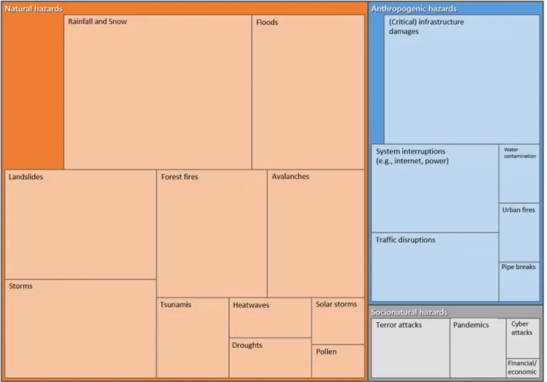
Regarding the specific hazards mentioned, we categorized them into natural, anthropogenic, and socio-natural hazards [66]. Natural hazards were the most mentioned, followed by anthropogenic and socio-natural hazards (Fig. 2). Among the natural hazards most prominently enumerated were rainfall and snow, storms, floods, landslides, forest fires, and avalanches. Regarding anthropogenic hazards, participants mainly mentioned damages to (critical) infrastructure, system in- terruptions such as power outages, and traffic disruptions. The listed socio-natural hazards included terror attacks and pandemics.
4.2. Which types of information about the hazards are appreciated?
In all workshops, it was emphasized that a multi-hazard app should be as “slim” as possible. This means that only the most relevant infor- mation should be on such an app itself and a “forwarding function” could be applied to redirect users to the platforms of the responsible authorities. On these platforms, interested users can find more infor- mation about a given hazard. In addition, the information on a multi- hazard app should be available offline, too, so that during a system interruption users still have access to behavioral recommendations, emergency numbers, and information on open shelters. Moreover, multiple formats should be applied to communicate the information (e.
g., maps, graphs, tables, text) to facilitate its understanding by a variety of audiences. In the next paragraphs, we outline which types of infor- mation the participants perceived as particularly relevant. A
corresponding summary table is listed in Appendix A-1.
4.2.1. Short-term and real-time information
Immediately before, during, and after a disaster, participants want information about the areas affected (e.g., epicenter), the severity of the hazard, the time (including the change-over time), and secondary haz- ards triggered by the main event (e.g., traffic disruptions, damages to critical infrastructure). Regarding the severity, not only the level of the hazard should be communicated but also what it implies for the re- cipients, thus having actionable hazard levels. Furthermore, some par- ticipants would also appreciate information about the likelihood of the occurrence for a certain event. Less often but also mentioned was in- formation about groups of people most affected, historical analogies (e.
g., 1.5 times as strong as the recent severe storm), temporary shelters, and, in particular for earthquakes, the probability of aftershocks.
The information classified by our participants as relevant was also identified in various other studies [18,46]. In particular, knowing which area is affected allows users to check whether their friends and family are safe [43]. Additionally, the demand for information about damages to infrastructure is valid as failures of the built environment pose the largest risk to safety in urban environments [48]. However, one has to also bear in mind that information needs change over time. For example, immediately after the first major earthquake in New Zealand, residents wanted to know what they should expect next and how they should respond. After a few days, they were also curious about the nature of the earthquake and the local geological settings. In comparison, after a
Fig. 2. Overview of the hazards that participants would combine with earthquakes on an app. Presented is a hierarchy chart based on the number of ref- erences in order to identify prominent themes. To this end, the child codes (N =21) are nested in the parent codes (N =3), and the more coding, the larger the area is (in total 219 references). The data are from seven workshops with a total of 28 participants.
major aftershock, the public was most interested in damage and welfare information [18]. This example shows that communicators need to be flexible in order to provide the information people need during certain periods.
4.2.2. Behavioral recommendations
Overall, participants demanded local, context-specific, and action- able behavioral recommendations. The recommendations provided should be short, clear, and simple because people might panic or be anxious during an emergency, which limits their information-processing capacity. To meet these requirements, the recommendations should be available in different formats, such as text, visualization, and video. One participant argued that this would allow people who do not speak the language in which the information is communicated to understand what they should and should not do.
In particular, behavioral recommendations during and immediately after an event were discussed, such as what one should and should not do, where to go (e.g., shelters), and where to get help. In addition to real- time recommendations, preventative behavioral recommendations, particularly for unpredictable hazards, are desired in order to be able to take precautionary actions. Some participants also mentioned behav- ioral recommendations for the recovery phase, such as how to ask for compensation payments or where to find information about (communal) support and reconstruction investigations.
Reuter et al. [12] also showed that end-users prefer a subdivision of behavioral recommendations into before, during, and after an emer- gency. In the event of an emergency, people primarily need timely ad- vices on what to do and what to avoid after an extreme event [49]. Up to now, standardized behavioral recommendations have been communi- cated to all users, neglecting individual needs and circumstances (e.g., people with disabilities). In consequence, future developments may lead to behavioral recommendations considering specific user needs and contexts (e.g., age, language, physical ability, house characteristics). In addition, most of the existing apps completely ignore communal pre- paredness actions, which should be included as well [30].
4.2.3. Long-term hazard and risk
As mentioned, the majority of the participants demanded a “for- warding function” to access long-term hazard and risk information. One participant stated: “The app should not only have an informative func- tion but also a forwarding one. The behavioral recommendations, for example, should be limited to the most important ones, and for further information users can click on a link redirecting them on a website with in-depth information.” Another participant added: “That [information about the long-term hazard] should not be the focus of the app. For this kind of information I use the internet.” This goes along with a repre- sentative Swiss study showing that people mainly use the internet and not apps to seek out such kind of information [37,67].
Regardless of whether the information is on an app or can be accessed via links, the following information on long-term hazard and risk is desired: (i) an explanation of the hazard and risk situation at one’s area of residence, (ii) statements about the likelihood that something will happen at a certain location, and (iii) a simple, scientific description of the nature of the hazards.
4.2.4. Maps
Reflecting on how to best display the current hazard situation on an app, participants preferred an interactive map with multiple layers. The participants wanted to be able to select by themselves which hazards are presented on the map. One participant underscored that it should be obvious at first glance which areas are affected by a hazard and with which severity (e.g., clear color scheme). Moreover, some participants would like to be able to click on hazard icons displayed on the map, which will open a subpage with detailed information about the current hazard. One group also discussed that if an app developer wants to integrate as many hazards as possible, he/she should work with sub-
categories. For example, having a map for natural hazards, one for anthropogenic ones, and one for the socio-natural hazards. Moreover, when it comes to secondary hazards, users should have the opportunity to zoom into the map to see the locally triggered hazards (e.g., infra- structure disruptions, pipe bursts).
Reuter et al. [12] and Dallo et al. [36] concluded too that people prefer that all hazards be displayed on a map, which also motivates them to seek further information. However, the map should be complemented with brief text to support user understanding [36,46].
4.2.5. Source of information
Participants wanted to know the information source. Answers to the questionnaire at the end of the workshop revealed that participants have the highest trust in federal authorities and scientific institutions. Less trusted are private institutions and the media. Therefore, indicating that the information comes from the responsible federal authority may in- crease people’s trust in the information and thus their intention to take actions.
Becker et al. [21] also showed that the information should come from an authorative, scientifically validated voice. Moreover, it is even better when the information is received from an expert who lives locally. The local focus allows people to assign credibility and trust to that infor- mation [18]. Bean et al. [20] added that placing the source at the beginning of the message improves credibility.
4.2.6. Contact list and information hotline
The majority of our participants wanted a list with the contact numbers of national and international emergency services (e.g., ambu- lance, police, rescue agency) in order to be able to ask immediately for help. In addition, during an ongoing event, it can also be useful to have an information hotline where people can ask specific questions. These results are supported by the findings of Karl et al. [16].
4.3. Which features should be available?
Many different features were written down during the brainstorming and low-fidelity prototyping sessions and brought up again in the ple- nary discussions. We will here focus on those discussed in-depth and those that were brought up in most of the workshops. The features are also summarized in Appendix A-2.
4.3.1. Push notifications
Push notifications, in particular for extreme events, were the most mentioned feature and thus seem to provide the biggest benefit for a multi-hazard app. The participants wished to receive (early) warnings whenever possible. Alternatively, they want to be informed immediately after an event. It should be obvious whether the push notification is a warning or provides information about an ongoing or a passed event.
Furthermore, all participants wanted to be able to select for themselves for which regions, hazards, and hazard levels they will receive push notifications. Regarding regions, not all participants are willing to activate GPS and thus would appreciate being able to select predefined areas (e.g., cantons in Switzerland). However, in cases of an extreme event, all users should receive a push notification regardless of the in- dividual settings. Besides the push notifications of an app, some par- ticipants mentioned that they have received alerts, for example in Australia or the US, via cell broadcasting. They appreciated this dissemination approach because it assures that everyone who is actually affected receives a warning. Moreover, some participants stressed that users’ should receive push notifications even if the app is only running in the background.
The participants also discussed some challenges with respect to push notifications. Firstly, it is challenging to provide local, context-specific information as wished by the participants. For example, one does not know whether or not a building is damaged and thus if it is safer to leave or to stay. Secondly, when users receive too many “false” notifications,
they switch them off or uninstall the app. One participant had observed such behavior among her friends and family the previous year: “I just wanted to say that research about storms at MeteoSwiss is very strong at the moment, which led to an increase of storm warnings. And this year, they released several warnings on the storm Petra that was, in the end, not as strong as forecasted. Afterward, the trust in the storm warnings decreased strongly, which I observed in my surrounding.”
These results are supported by the findings of several other studies.
Reuter et al. [12], for example, also showed that individually adjustable setting options are desired by the users, which can release a sense of self-responsibility in people [37] and increase the credibility of the push notifications [20]. Moreover, a link on the notification that forwards the users to the official website with more detailed information shortens their verification process and in turn shortens their response time to take (precautionary) actions [22]. However, Kaufhold et al. [14] showed that some people also struggle with push notifications as they do not really know how to respond to the information received. Thus, people might need an explanation about the content and aim of the notifications.
4.3.2. Button to ask for help and “I am safe” button
In several workshops, participants voiced the need for a button to make an emergency call. Some participants referred to a Swiss app (Rega) allowing the user to transmit their current position to the oper- ation center with only one swipe. In particular, during emergencies in which persons may be injured, such a feature can save lives.
In addition, participants also wanted an “I am safe” button that al- lows them to immediately inform family members and friends that they are safe. It should thus be possible to insert the contact details of persons who should receive such message in the app beforehand. Another option could also be that the “I am safe” message is spread on the users’ social media accounts (e.g., Twitter, Facebook). One participant mentioned that a comparable feature is the “Safety Check” on Facebook. During the terror attack in Paris [8] and during the earthquake in Nepal [9] in 2015, for example, people used this feature to communicate on Facebook that they were safe.
4.3.3. Sharing feature
A feature allowing the sharing of information, warnings, or alerts via social media, email, or text messages with friends and family members was mentioned in most workshops. One participant stated: “[…] The use of various communication channels allows to also warn people who have not downloaded the app or do not have a smartphone at all.”
These findings are in line with the results of several other studies showing that people appreciate the possibility of sharing notifications with friends and family [12,36,43,49]. This is certainly one of the rea- sons why many warning and disaster apps, such as LastQuake, GeoNet, and Katwarn, have already embedded such a feature.
4.3.4. Chat forum
Out of the workshop discussions, three chat forum approaches can be derived. Firstly, the chat forum could serve as a platform to advertise and coordinate communal support. In this context, four participants referred to the current platforms established for the COVID-19 pandemic. Secondly, it could be a forum where users can pose ques- tions to experts or emergency services. Thirdly, the chat forum could work as an information and experience exchange platform whereby users can also upload photos and videos.
We highlight here two exemplary apps that are already operating a chat forum. The app Earthquake Network, for example, provides public rooms in different languages. As a user, you can register and chat with other users. The app developer defines a moderator for each chat, in most cases a local expert, who can provide additional information when an earthquake has occurred. As a result, the need for information can be fulfilled by the users themselves by providing information about what they are experiencing [43]. Another example is the app LastQuake, which opens a new chat for each event. People affected can then upload
pictures and exchange their experiences with others. Additionally, users can rate the comments of the others [68].
4.3.5. “Report an event” button
A button to report a hazard was also discussed. For example, for earthquakes, you can let users fill out felt reports in order to gather data about the felt intensity of the earthquake. In addition, participants also discussed the option to be able to upload geo-located pictures or write experience reports in order to contribute to the local damage assess- ment. One participant thought, “[this] will give them a feeling of being useful and of contributing to mitigate further risks.”
Wald et al. [15] concluded that “Did you feel it” reports seem to provide emotional help to citizens who just had a frightening experience by allowing them to share their experiences and enabling them to contribute their observations toward a general understanding of the phenomenon. In addition, Kaufhold et al. [14] showed that the emer- gency app 112.social facilitates communication between citizens and authorities by letting users send so-called “app-alerts” (including written text, pictures, and videos) to the authorities. However, one should consider that such a service faces certain challenges. In order to work effectively, sufficiently skilled and trained staff are needed [23].
Another challenge of such features is that spreading disaster pictures can create panic or inappropriate crisis tourism [12].
4.3.6. Interlinking existing apps
Several participants suggested interlinking different apps in order to avoid duplications and to provide added value. One participant, for example, had the idea that push notifications for extreme events should be spread via weather apps, messenger apps, or public transportation apps that a large percentage of the society is already using. Additionally, specific information should then be communicated via disaster apps.
Moreover, a connection to a first aid app was classified as beneficial because in an extreme event you may need clear instructions on how you can help a person who is injured. One participant also brought up the idea of collaborating with Google as they are starting to release warnings and alerts about different hazards, too. Furthermore, another participant suggested ensuring that the app is pre-installed on all smartphones.
However, it is important that the same message is not spread via too many channels, as one participant stressed: “At some point it just gets on your nerves when you receive from three or four different apps the same message.”
4.3.7. Further issues
Some further features were mentioned but only by a few participants, as follows: (i) a live (news) ticker with the latest information, (ii) awareness tools (e.g., regular questionnaires, games), (iii) a self- generated test alert, (iv) a decision support tool (i.e., after having answered a set of questions, the users are provided with specific behavioral recommendations), (v) a traffic light system (i.e., a simple green-orange-red classification of the severity of the hazard), and (vi) a route planer (i.e., which calculates for the users how they can get from A to B by avoiding impassable roads).
Other research studies have also identified the need for these fea- tures, in particular for a test alert [12,51], awareness tools [30], and a live (news) ticker about the hazard situation [12]. Awareness tools such as quizzes and games can increase users’ preparedness, and with, for example, a score scheme you would also be able to monitor long-term behavioral changes [30].
4.4. Recommendations for multi-hazard app content
In section 4.1 to 4.3, it became clear that most of our findings are in line with the results of other studies assessing users’ needs for and ex- pectations of single-hazard or disaster apps. We showed that these needs are similar for the design of multi-hazard apps in general and for the inclusion of information about low-probability hazards in general-
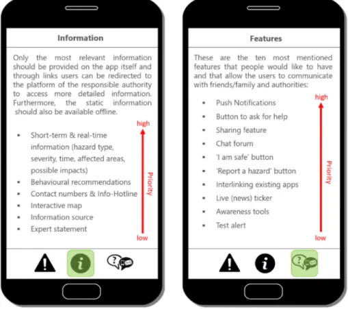
purpose apps (e.g., weather apps). However, the range of information and features mentioned by the participants is broad wherefore a prior- itization is needed to avoid an information overload. In Fig. 3, we listed the information and features in descending order of number of mentions.
The arrows present a possible prioritization, at the top are those features most participants wanted and at the bottom those which are only wished by a few participants.
Regarding the hazard information, we see great potential in using the multi-hazard app as an entry point providing a large audience with the first relevant hazard information. Through forwarding functions, users are then redirected to the official single-hazard platforms with more detailed information. Based on our results, we determine real-time in- formation (i.e., hazard type, severity, time, location, possible damages) and behavioral recommendations as relevant information that should be directly available on the app. Moreover, a map helps for the contextu- alization and contact numbers could be added in case of an extreme event in which people might need immediate help.
Regarding the features, we recommend implementing push notifi- cations as they were by far most mentioned. Push notifications are a good complement to the existing communication means (e.g., radio, television, sirens, email) with the aim to warn/inform as many people as possible. Additional features are also beneficial as mentioned in section 4.3, but for example a chat forum or a report button need human re- sources to operate them and analyze the data. In addition, social media and other web providers (e.g., google) have already implemented similar features (e.g., ‘I am safe’-button) and it has to be explored whether these are actually needed on a multi-hazard app or not.
4.5. Limitations and future research
The chosen study design brings many advantages but also some limitations. One limitation concerns the age of the participants. We
recruited persons aged between 20 and 35 years because this generation regularly uses smartphones. In future studies, the needs of other age groups (e.g., seniors) should be explored as well to check whether they would also be reached with an app or other communication channel(s).
Another limitation is the comparably small sample size. However, we reached the saturation point after seven workshops.
Our study addresses the question of which hazard types, hazard in- formation and features should be embedded in multi-hazard apps. Thus, these findings do not directly explore whether the information and features preferred by the participants contribute to behavioral change or an increase in preparedness. However, many participants mentioned features or apps that they already use regularly and additionally linked their needs to the current COVID-19 emergency. For example, picto- grams showing the behavioral instructions to decrease the spread of the coronavirus are appreciated. Therefore, our findings give insights into features that people need during emergencies. However, similar work- shops could be hold with persons who have already experienced an extreme event to see whether they demand for the same features.
Our participants mentioned a wide range of features and pieces of information they would like to have on an app. However, they also said that the app should be as “slim” and as intuitive as possible to use. We have tried to make a first prioritization based on the number of partic- ipants demanding for certain elements. However, we encourage other researchers to further investigate which features are actually needed to improve users’ ability to take informed decisions. It should be investi- gated in more detail, which information should be on a multi-hazard app itself and which information can be accessed on other existing platforms.
This information division of course depends on the communication landscapes of the different countries/regions and the roles of the involved stakeholders.
Whereas our study is based on an artificial setting and the design of low-fidelity prototypes, the effectiveness of apps and their contents and
Fig. 3. Recommendations for multi-hazard app content. On the two displays, the pieces of information and the features are listed in descending order of number of mentions. The red arrows represent a possible prioritization based on the number of participants demanding for them. (For interpretation of the references to color in this figure legend, the reader is referred to the Web version of this article.)
features should also be tested with a static prototype [50] or a prototype in real-life settings. Robbins [25] recommends in-app surveys along with fieldwork to solicit input from non-users, too. A participant of our virtual workshops additionally brought up the idea of having a feedback questionnaire after receiving a notification in order to assess the users’
reactions to and perceptions of the usefulness of the notification. In our next study, we also aim to develop a prototype based on our findings and the findings of other studies and test it with persons from the public.
Our analysis focuses on an exploration of the public’s needs. Future research is needed to evaluate how the features could be operational- ized, how the providers of existing apps could collaborate with each other, and how the information flow (e.g., updating process, release) between the responsible agencies could be guaranteed. To this end, the participants mentioned the following three challenges that need future consideration: (i) the information complexity when combining several hazards, (ii) ensuring low battery consumption, and (iii) the operation of a multi-channel communication system ensuring that the information is consistently spread on the different channels.
Furthermore, in many discussions, “trust” was mentioned as decisive regarding actually taking actions. Our findings show that three factors increase people’s trust, as follows: (i) indication of the information source, (ii) individual adjustable settings, and (iii) federal authorities and institutions being the source of the information. Tan et al. [50] also listed trust as an important factor in their usability guidelines and further research is needed to analyze how trust can be maintained when for example push notifications come from different sources or the users are redirected to different platforms. However, not only trust but also other factors such as risk perception and individual skills or knowledge influence people’s response to a warning or alert [69]. Further research is needed to explore the impact certain factors have and how they in- fluence each other.
Additionally, the issue of “data privacy” and “data protection” led to lively discussions by our participants. Our participants tend to be hesi- tant when an app requires access to personal data such as contacts and GPS although they want as personalized information as possible. One participant stated that users should be informed as to which types of data are gathered and why they are actually needed (e.g., to send tailored push notifications). Also, Fischer et al. [6] showed that data security issues negatively affect people’s intention to use a warning app and to comply with behavioral recommendations. For example, cell broadcasting is not allowed in every country (i.e., no legal basis). Thus, future research is needed addressing data privacy issues in order to avoid misuse of personal data and to ensure the widespread use of an app.
As a last point, the participants clarified that the information should be as simple as possible and easy to understand. Tan et al. [50], for example, suggest using non-visual outputs (e.g., audio), utilizing exist- ing interfaces that are familiar to users and using meaningful visuali- zation (e.g., images, maps). Based on our results, we also see a potential in offering push notifications with an audio to reach deaf people as well as to warn persons who left their smartphone in another room, in particular for hazards that ask for immediate action. However, addi- tional research is needed on how to best implement these features and to
assess their impact. Further research is also needed to assess which in- formation format users understand best [38] and how multiple hazards can be displayed on one map ensuring that the relevant information can still be digested [36]. An interesting research approach would be to analyze if common mapping software (e.g., google maps) should be used to display the current hazards as most people are familiar with these interfaces.
5. Conclusion
So, why using multi-hazard apps? The results of our study offer three reasons for authorities or other institutions why operating multi-hazard apps could be advantageous. First, the public demands for it. People do not want to download a separate app for each hazard but instead they would like to have an app providing them with information about all relevant hazards. Second, a multi-hazard app can be used as a first entry point for multiple responsible authorities. This allows a joint develop- ment and operation of an app and allows reaching a larger audience. To this end, users could receive warnings and other relevant information on a multi-hazard app. Through forwarding functions, they further would have access to more information on the official single-hazard platforms.
This also ensures that the app is not too heavy and prevents the users from being overwhelmed with too much information. Third, a multi- hazard app allows the implementation of interactive features (e.g., push notification, ‘I am safe’-button, chat forum) which are useful for managing different hazards and therewith increase society’s ability to take actions and to build a shared understanding of an event.
After having decided to use a multi-hazard app, it is crucial that the operators or authorities investing in the development of such apps design them based on usability guidelines [50]. Furthermore, the op- erators have to check continuously that the apps meet the users’ needs and have to investigate in the collaboration between the involved stakeholders (e.g., civil protection, federal institutions responsible for the hazard assessments).
Declaration of competing interest
The authors declare that they have no known competing financial interests or personal relationships that could have appeared to influence the work reported in this paper.
Acknowledgements
The authors would like to thank Michael Stauffacher (TdLab ETH Zurich) for his continuous, valuable feedback during the study and all participants for the fruitful and enthusiastic discussions during the vir- tual workshops. The authors also thank the reviewers for their valuable comments, which strongly improved the clarity of our findings. This project is part of the Real-time Earthquake Risk Reduction for a Resilient Europe ‘RISE’ project, which has received funding from the European Union’s Horizon 2020 research and innovation program under grant agreement No. 821115. This research was approved by the Ethics Committee of ETH Zurich (EK 2020-N-46).
Appendix A. Summary tables of the public’s information needs and app feature preferences
Appendix A1: Information about the hazards that the participants perceived as relevant. We categorized the types of information into themes (column 1) that are decreasingly listed according to the number of files (discussion transcripts, brainstorming slides and summary slides) in which the themes are present (column 3). The second column summarizes the issues discussed with respect to each theme. The data are from seven workshops with a total of 28 participants
Information themes Specifications Number of files/
mentions Short-term and real-time
information - Affected areas (e.g., epicenter of an earthquake, regions affected by a heatwave) - Severity of the hazard (e.g., intensity, extent of the danger)
- Time (including time-frames, change over time, and decay)
- Triggered hazards (e.g., danger of building collapse, traffic disruptions, damaged hospitals, (critical) infrastructure damages)
- Current risk and hazard
- People particularly at risk (e.g., elderly people)
- Historical analogies (e.g., in comparison to previous events)
•Normalization bias (i.e., no preparation measures are taken because people think: “I survived the last hurricane with the same intensity so I will also survive this one.”)
- References to safe places (e.g., shelters) - Probability of aftershocks
65/101
Behavioral recommendations - Preventative behavioral recommendations
•In particular for unpredictable hazards in order to take precautionary measures before an event - Behavioral recommendations during or immediately after an event
•Where can I go (e.g., safe places)
•“Dos and Don’ts”
•Where can I get help
•First-aid measures
•Short and simple because people might panic or be anxious - Behavioral recommendations in the recovery phase
•How can I ask for compensation payments
•Information about (communal) help and reconstruction investigations - In general
•The recommendations should be as local and context-specific as possible (e.g., I am in the mountains and I receive a storm warning what should I do?)
•Not only indicate a hazard level but also what it implies for a person, i.e. actionable hazard levels.
•The behavioral recommendations should be available in different formats (e.g., text, pictures, videos).
21 / 68
Long-term hazard and risk - Hazard and risk situation
•Which hazards exist at my place of living?
•How likely is it that something will happen at a certain place?
- Simple, scientific description of the nature of the hazard
- In general, most participants argue that information about long-term hazard and risk should not be included to an app itself. Instead, users should be redirected via links to the platform of the responsible authority or institution.
17 /24
Contact numbers and
Information hotline - List with contact details of national and international emergency services.
- During an on-going event, operate an information hotline, which allows people to ask for further information and help (as it was done for COVID-19 in many regions/countries).
15 / 22
Map - Interactive map with different layers, which allow users to select by themselves which hazards and at what hazard levels are displayed.
- Clear and comprehensible hazard icons
- Work with colors that represent the severity of the hazard.
- At first glance, it should be clear which areas are affected by a hazard.
- By clicking on an icon, a subpage or a new window with further information opens.
- Zoom-in function in order to check whether there are any local damages (e.g., water contamination, disrupted traffic routes, chemical accidents).
13 / 29
Information source - Indicate information source
- People have higher trust in federal authorities and research institutions than in private institutions or the media.
- If users know the source, they can directly ask questions to the responsible authority.
5 / 9
Expert statement - Particularly for extreme events, one participant would prefer a statement by a scientific expert to verify the information
communicated by the media for example. 1 / 1
Appendix A2: Features that the participants would appreciate on a multi-hazard app. The features (column 1) are decreasingly ordered according to the number of files (discussion transcripts, brainstorming slides and summary slides) in which the features are present (column 3). The second column summarizes the main discussion points regarding each feature. In the fourth column, some exemplary apps that have already implemented such features are listed. The data are from seven workshops with a total of 28 participants
Features Specifications Number of files/
mentions Examples
Push notifications - For extreme events, all users should receive a push notification (default setting).
- For “smaller” events, each user should be able to decide by him-/herself whether he/she wants to receive notifications or not.
- Locally context-specific, either activate GPS or select predefined regions (e.g., cantons in Switzerland) - Individual setting options with regard to location, hazard type & hazard level
21 / 60 - NINA
- MeteoSwiss - AlertSwiss - WIND
(continued on next page)