1
Holocene climate variability based on two lacustrine sediment sequences from Cádiz,
southern Spain.
I n a u g u r a l - D i s s e r t a t i o n
zur
Erlangung des Doktorgrades
der Mathematisch-Naturwissenschaftlichen Fakultät der Universität zu Köln
Köln, 2017
Vorgelegt von:
Jasmijn van ´t Hoff
aus Leidschendam
2 Berichterstatter: Prof. Dr. Martin Melles
(Gutachter)
Prof. Dr. Klaus Reicherter
Prof. Dr. Juan Ignacio Santisteban Navarro
Tag der mündlichen Prüfung: 07.07.2017; 10.00 Uhr
3
4
5 Laguna de Medina on a cloudy day
Picture by Florian Steiniger
6
I
Abstract, Kurzfassung
7 Abstract
Iberia, and especially southern Spain, has been the focus of only limited palaeoclimatological research.
The scarcity of palaeoclimate archives has led to an interpolation of archives from distant sites. The palaeoclimate reconstruction of southern Spain is therefore mainly based on the interpolation of marine records from the Alboran Sea, the Gulf of Cádiz and the North Atlantic Ocean. The understanding of the impact and effects of Holocene changes is relatively poor. The execution of palaeoclimatological research in southern Spain has been hampered by the lack of suitable sites. This thesis contributes to the understanding of the Holocene climate change in southern Spain with two new cores drilled in shallow saline lakes. The arid southern Spain is a region without deep natural lakes, these ´salinas´ represent a promising alternative for palaeoclimate research.
In this thesis, the methods and results of sedimentary and palaeoclimatological analyses of the modern lake sediment and soil catchment samples of Laguna de Medina, and the sediment sequences of Laguna de Medina and Laguna Salada are presented. The methods include XRF scanning, MSCL logging, particle-size analysis, total (in)organic carbonate analysis, determination of total sulphur, and total nitrogen, and XRD analysis, reinforced with the statistical method principal component analysis. The results are used to characterize the sediments and to interpret the changing climatological and environmental settings during the Holocene. The modern sediments of Laguna de Medina were studied with the same methods, to obtain a modern analogue for the long record.
The primary objective of this thesis was to disentangle the Holocene climate of southern Spain, based on the lacustrine archives Laguna de Medina and Laguna Salada using 25.65 and 12 m long cores, respectively.
Shifts in sedimentary deposition and geochemical proxies identify that southern Spain is highly vulnerable and responsive to climate change. Sedimentological, geochemical, mineralogical and granulometric analysis of the lacustrine sediment sequences provide a detailed palaeoclimatological and –hydrological reconstruction of the changes for the last 9,600 cal yr BP (Laguna de Medina) and 8,500 cal yr BP (Laguna Salada).
Based on these two new lacustrine archives, this thesis provides the first high-resolution palaeoclimate reconstruction for southern Spain and a new archive for the Holocene from a shallow desiccated lake.
The two cores provide insight in the Holocene climate evolution, which is divided into three stages in southern Spain: 1) the warm and arid Early Holocene, 2) the humid climatic optimum in the Middle Holocene, and 3) the progressive aridification trend in the Late Holocene. The high-resolution record of Laguna de Medina gives insight in the timing and duration of rapid climate changes (RCC´s) during the Holocene. Five arid periods 9,160-7,870, 5,780-4,800, 3,150-2,420, 1,950-1,450, and 1,264-550 cal yr BP and one humid period 550-170 cal yr BP could be identified and related to RCC in the Holocene. The sequence of Laguna de Medina reinforces the connection between global changes in the hydrological regime, rapid climate change and North Atlantic Oscillation dynamics.
8 Kurzfassung
Iberia, und im Besonderen Südspanien, waren bisher nur wenig im Fokus der paläoklimatologischen Forschung. Der Mangel paläoklimatologischer Archive führte zu einer Interpolation weitentfernter Archive. Die paläoklimatologische Rekonstruktion Südspaniens basiert daher hauptsächlich auf der Interpolation von marinen Records des Alborischen Meer, des Golfs von Cádiz, und des Nordatlantischen Ozeans. Das Verständnis der Auswirkungen und Effekte der holozänen Veränderungen ist relativ schlecht. Die Durchführung paläoklimatologischer Forschung würde durch den Mangel an geeigneten Lokationen behindert. Diese Dissertation trägt zum Verständnis der holozänen Klimaveränderungen in Südspanien, anhand zweier, neu gebohrter Kerne aus flach salzigen Seen, bei. Das aride Südspanien ist eine Region ohne natürlich tiefe Seen, aber dafür sind die ´salinas´
eine vielversprechende Alternative für die paläoklimatologische Forschung.
In dieser These werden die Methoden und Resultate der sedimentologischen und paläoklimatologischen Analysen der modernen Seesedimente und Bodenproben des Einzugsgebietes der Laguna de Medina, und die Sedimentsequenzen der Laguna de Medina und der Laguna Salada präsentiert. Die Methoden umfassen Röntgenfluoreszenzmessungen (XRF), Multisensorkernlogging (MSCL), Korngrößenanalyse, die Analyse des gesamten (in-) organischem Karbonates, die Bestimmung des gesamten Schwefel und gesamten Stickstoff, und Röntgendiffraktionsanalyse (XRD), kombiniert mit der statistischen Methode der Hauptkomponentenanalyse. Die Resultate werden benutzt, um die Sedimente zu charakterisieren, und um die veränderten Klima- und Umweltbedingungen während des Holozäns zu interpretieren. Die modernen Sedimenten der Laguna de Medina sind mit den gleichen Methoden analysiert worden, sodass ein modernes Analog für den langen Kern entstand.
Das Hauptziel dieser These war es das holozäne Klima Südspaniens zu rekonstruieren, basierend auf den lakustrinen Archiven der Laguna de Medina und der Laguna Salada, unter Benutzung der 25,65 m und 12 m langen Kerne.
Änderungen der sedimentologischen Ablagerung und der geochemischen Proxies zeigen, dass Südspanien sehr anfällig für Klimaänderungen ist und darauf reagiert. Sedimentologische, geochemische, mineralogische und granulometrische Analysen der lakustrinen Sedimentkernen liefern eine detaillierte paläoklimatologische und hydrologische Rekonstruktion der Veränderungen der letzten 9.600 Kalender Jahre vor heute (Laguna de Medina) und 8.500 Kalender Jahre vor heute (Laguna Salada).
Basierend auf diesen zwei neuen, lakustrinen Archiven, stellt diese These die erste hochaufgelöste, paläoklimatologische Rekonstruktion für Südspanien dar, und umfasst ein neues holozänes Archiv aus einem flachen, teilweise ausgetrockneten See.
Die zwei neuen Kerne geben Einblick in die holozäne Klimaevolution, die sich in Südspanien in drei Stufen gliedert: 1) das warme und trockene Frühe Holozän, 2) das feuchte Klimaoptimum während des Mittleren Holozäns, und 3) die progressive Aridifizierung des Späten Holozäns. Der hochaufgelöste Kern der Laguna de Medina gibt Einblicke in die Zeit und Dauer der rapiden Klimaveränderungen (RCC) während des Holozäns. Fünf trockne Perioden wurden mit den RCCs im Holozän verbunden 9.160-7.870, 5.780-4.800, 3.150-2.420, 1.950-1.450 und 1.264-550 Kalender Jahre vor heute und eine feuchte Periode zwischen 550-170 Kalender Jahre BP. Die Sequenz der Laguna de Medina verstärkt die Verbindung zwischen globalen Änderungen im hydrologischen Regime, dem RCC und der Dynamik der Nordatlantische Oszillation.
9 Coring team on the platform
Picture by Helmut Brückner
10
II
Acknowledgments
11
12 Acknowledgments
My first acknowledgment goes to the Deutsche Forschungsgemeinschaft for financially supporting the project CRC 806 ‘Our Way to Europe´ for what I am writing my thesis. Their support also gave me the opportunity to attend some international conferences, and networking with other scientists working in Spain. I also want to thank the GSGS graduate school of Cologne, for financially supporting the last six months of my thesis with the Fellowship Grant No. GSGS-2017A-F01 of the Graduate School of Geosciences. It was due to this support, I had the change to finish my thesis.
The results of this thesis improved a lot by the contribution and discussions with numerous colleagues.
My special thank goes to my supervisors Martin Melles and Klaus Reichterter. They introduced me into the field on palaeolimnology, and gave me advice and support the last three years. Martin Melles discussed with me about the data and helped me a lot improving my writing skills. Klaus Reichterter knows all the good coring spots in Spain, and helped a lot during the field campaigns. Furthermore, I want to thank Helmut Brückner, who kindly provided the platform coring equipment for our field campaigns in September 2014 and March 2015.
I want to thank Tabea Schröber, my colleague from Aachen with whom I work closely together on the cores. It was inspiring, discussing the data and really fun measuring everything together, and exploring the university by night.
Rosa Mediavilla, working in the geological department Madrid (IGME) and Santi Estaban, working in the University of Madrid, were of great help during the core description and the interpretation of the different facies. They taught me a lot about the Spanish processes, wherefore my greatest thank.
Furthermore, I thank Finn Viehberg for his cooperation in Laguna de Medina by counting the ostracods, which helped me a lot by the palaeoenvironmental reconstructions.
Janna Just is thanked for her motivational speeches, discussions, structural adjustments, and proofreading parts of my thesis. Alexander Francke is thanked for introducing me the age model software, and Ascelina Hasberg is thanked for her great translating skills.
I really want to thank all the other colleagues for the nice working atmosphere the last three years!
Dorothea Klinghardt and Nicole Mantkeare from the laboraties of Cologne, and my student assistants Christian Steffens and Anne-Sophie Mreyen, are greatly acknowledged for their enduring help in the laboratory and with the ArcGIS database.
I want to thank all the students and colleagues who helped during the two field campaigns: Martin Melles, Klaus Reicherter, Helmut Brückner, Tabea Schröder, Florian Steiniger, Janna Just, Raphael Gromig, Matthias Thienemann, Sandra Jivcov, Ascelina Hasberg, Matthias Lenz, Franz Hartung, Jan von Harten, Christian Steffens, Christian Scharrenberg, Daniel Kayser, Simon Washausen, and Marcel Baum. It was not only the physical strength, but also the cooking, barbequing, playing flunky ball, and drinking, what made the field campaigns a great successful time.
Special thanks goes to the guards of the Laguna de Medina and Laguna Salada, the Junta de Andalucía for their permission to core in the nature reserves, and their hospitality and cooperation at the lakes.
I want to thank the bachelor students who wrote their Bachelor thesis on one of the lakes: Raphael Petri, Sebastian Fuhr, Sandra Blanke, Patrick Braun, Tim Stanski, Gabriele Schmidt, and Jennifer Kösling.
This really helped me a lot, and it was fun discussing with you, and reduced the laboratory work significantly.
I would like to thank my family, especially my parents Rosemarie Ritzema and Jan van ´t Hoff, as well as my brother Jasper van ´t Hoff and my sister Fleur van ´t Hoff for their support in everything I do. I would also like to thank my lovely zwijnenvriendinnetjes, who gave me distraction and support whenever I needed it.
Last, but not least, I would like to thank my beloved Thomas Schlink, for his patience in the last writing phase, as well as taking care if was eating and drinking enough, and just for being there!
Additionally, I would like to thank Prof. Dr. Frank Schäbitz for taking the chair of the examination committee as well as Dr. Finn Viehberg for acting as assessor at my defence.
13 Laguna de Medina on a cloudy day
Picture by Franz Hartung
14
III
Contents
15 Contents
I Abstract 6
Kurzfassung 7
II Acknowledgments 11
III Contents 14
Chapter 1: Introduction 17
1.1 Motivation 18
1.2 CRC 806 20
1.2.1 The origin of hominids 20
1.2.2 The C Cluster: The Western Mediterranean – Bridge or Barrier? 21
1.3 Terrestrial palaeorecords in southern Spain 23
1.3.1 Lacustrine environments in Spain 23
1.3.2 Holocene palaeoclimate archives in (southern) Spain 24
1.4 Study sites 26
1.5 Objectives 27
Chapter 2: Modern sedimentation processes in Laguna de Medina, southern Spain, derived from lake surface and soil catchment samples
31
2.1 Abstract 33
2.2 Introduction 34
2.3 Study site 35
2.4 Materials and methods 37
2.5 Results 39
2.6 Discussion 43
2.7 Conclusions 45
Chapter 3: A high-resolution Holocene palaeoclimate record from the Laguna de Medina, Cádiz, southern Spain
47
3.1 Abstract 49
3.2 Introduction 50
3.3 Study site 51
3.4 Materials and methods 53
3.5 Results 55
3.5.1 Sedimentolog and geochemistry 55
3.5.2 Ecological proxies: Ostracods and foraminifera 57
3.5.3 Chronology 60
3.6 Discussion 61
3.6.1 Origin of allochthonous and autochthonous sediment components 61
3.6.2 Genesis of the facies 63
3.6.3 Age model 65
3.7 Interpretation 66
3.7.1 Comparison with Reed et al. (2001) record from Laguna de Medina 66 3.7.2 Long-term palaeoclimate reconstruction / Long-term depositional history 67
3.7.3 Short-term climate events: Rapid Climate Change 70
3.8 Conclusions 73
16 Chapter 4: A Holocene palaeoclimate record from the Laguna Salada, Cádiz,
southern Spain
75
4.1 Abstract 77
4.2 Introduction 78
4.3 Study site 79
4.4 Materials and methods 81
4.5 Results and Discussion 82
4.5.1 Chronology 82
4.5.2 Sedimentation rate 83
4.5.3 PCA: Origin of allochthonous and autochthonous sediment components 84 5.5.4 Palaeoclimatological / Palaeohydrological reconstruction 85
4.6 Conclusions 89
Chapter 5: Synthesis 91
5.1 Synthesis 92
5.1.1 How do the modern processes help to unravel the palaeoprocesses? 92
5.1.2 How can we obtain a reliable age model? 93
5.1.3 What are good proxies to reconstruct the palaeoclimatolocigal conditions in saline environments?
94 5.1.4 Are the Holocene climate events synchronous in the two records, and how
about the entire Iberian Peninsula?
95 5.2 Importance of Laguna de Medina and Laguna Salada for the CRC 806 97 5.3 The future for Laguna de Medina and Laguna Salada with the focus on the
ongoing climate change
98
References 100
Erklärung 113
Lebenslauf 114
17 Laguna de Medina and the platform
Picture by Helmut Brückner
18
Chapter 1
Introduction
19 1.1 Motivation
Since 1950, the climate is changing in a more rapid way as has been seen before. The atmosphere and ocean are warming, snow and ice are melting and the sea level is rising (IPCC, 2014). The ongoing climate change is affecting areas in different ways. Polar regions are getting warmer resulting in ice and glacier melting, and the rise of the sea level. Humid regions are getting more humid and arid regions are getting more arid (IPPC, 2014).
The arid southern Spain is very vulnerable for climatic changes (Giorgi and Lionello, 2008). The ongoing climate change leads to an increase in air temperatures, a decrease and more irregularity in precipitation (Bolle, 2003; de Castro et al., 2004; Met Office, 2011), and thus, to reduced water availability for surface and aquifer systems (Álvarez-Cobelas et al., 2005a). Aquifers, which are already overexploited, will experience problems with salinization (Puigdefábregas and Mendizabal, 1998). The changes in precipitation and evapotranspiration will not only affect the environment, but also the economy of Spain. Tourism and agriculture, two highly water-consuming sectors, will become more important in a socio-economic way (Gleick, 1993). Currently, tourism is the national work force for 13 % of the population, but it will be hard to justify and maintain the enormous water use for tourists when the population suffers from water stress (Hein et al., 2009).
From the ecological point of view, the ongoing climate change will have devastating effects on limnological systems. Spain has the greatest diversity of inland aquatic systems of Europe, containing unique flora and fauna, mainly triggered by the differences in climate, geology and the hydrological characteristics (Álvarez-Cobelas, 2005a). 49 Spanish wetlands are protected by the Ramsar Convention on Wetland of International Importance (Ramsar, Iran, 1971), including Laguna de Medina and Laguna Salada, the two lakes described in this thesis.
Not only for the future of the Spanish lakes, climate predictions and the understanding of the Mediterranean limnology is important. It is very likely that in the course of climate changes the cold temperate limnological systems become more similar to the current Mediterranean limnological systems, so it is good to have references to the new stage of these systems (Arnell et al., 1996; Álvarez- Cobelas et al., 2005b).
Álvarez-Cobelas et al. (2005b) listed the three most important questions about the Spanish limnological ecosystems:
- Will they still exist at the end of the century?
- Are they still permanent or did they become temporary?
- Will the biochemistry or biota change?
It is hard to answer these questions for the Spanish limnological systems at this point. Firstly, because only a few long-term studies exist and more research about Spanish limnological systems is needed.
Secondly, the human influence on these systems cannot be predicted exactly. Álvarez-Cobelas et al.
(2005b) wrote: ´Many endangered Mediterranean limnosystems will survive if, and only if, Mediterranean societies appreciate them (which is not the case right now)´. In addition, regional climate models are at this stage not precise enough to predict the impact of global climate change in a regional scale.
The current atmospheric concentrations of the greenhouse gasses (GHG) CO2, CH4, and N2O exceed the highest concentrations recorded in the ice cores during the last 800,000 years (IPCC, 2013b). Since 1750, the concentration of CO2, CH4, and N2O increased by 40, 150, and 20 %, respectively (IPCC, 2013b). Without analogue GHG conditions in the last 800,000 years, it is hard for climate modellers to develop a reliable model. Although climate modellers continued to develop climate models, climate fluctuations can still not be predicted precisely, not even until the end of this century. To predict the future climate changes, it is important to concentrate on the more recent past, the Holocene, where the boundary conditions are relatively similar as today. Especially, compared with the large changes
20 between glacial and interglacial periods (Wanner et al., 2008). During the Holocene, most of the terrestrial environments developed that are still persisting today (Wanner et al., 2008).
For this purpose, it is important to have reliable palaeoclimate and -environmental archives in different regions.
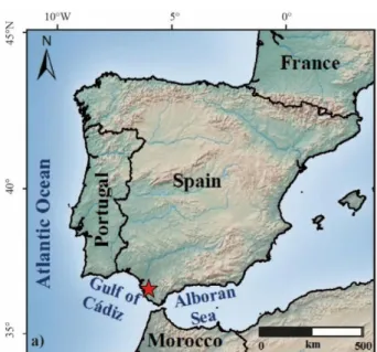
Relatively little is known about climate variations of southern Spain. Records, which continuously cover the last glacial-interglacial cycle, are mainly found in marine archives from the Alboran Sea (e.g. MD95- 2043; Cacho et al., 1999), the Gulf of Cádiz (e.g. MD99-2339; Voelker and de Abreu, 2011), and the North Atlantic off Portugal (e.g. MD95-2042; (Sánchez Goñi et al., 1999)) (Fig. 1.1). Although these records cover a long temporal range, the resolution, especially for the Holocene, is insufficient to reconstruct centennial-scale climatic changes throughout the Holocene.
Terrestrial archives are sparse, especially in southern Spain, and often only covering (partly) the Holocene (Fig. 1.1). Therefore, the palaeoclimate of southern Spain is mainly based on the interpolation of distal marine records. The distance between the terrestrial archives is up to 600 km, crossing the climatic zones of the humid Atlantic IP (Portugal) to the arid Mediterranean IP (Schuck et al., 2013).
Most of the terrestrial records do not have high-resolution data, or do not cover the entire Holocene.
Extending this database with new archives will enhance the knowledge about the palaeoclimatic conditions and will help to tune the climate models for better climate predictions, especially for the tip of southern Spain.
Lakes are promising archives for continental palaeoclimate and –environmental reconstruction (Cohen, 2003), because lacustrine sedimentary sequences can provide continuous high-resolution records (Moreno et al., 2012).
In the scope of the extension of lacustrine records, two lakes from the southern tip of Spain were cored during two field campaigns in September 2014 and March 2015, Laguna de Medina and Laguna Salada (Cádiz). The palaeoclimatological and -environmental conditions reconstructed from these retrieved sediments are the focus of this thesis.
Fig. 1.1: Location of selected continental (orange dots), and marine archives (blue dots), as well as the locations of the studies lakes Laguna Salada and Laguna de Medina (red stars).
21 1.2 CRC 806
This PhD thesis was conducted within the Collaborative Research Centre 806 (CRC 806) ´Our Way to Europe – Culture-Environment Interaction and Human Mobility in the Late Quaternary´. This is a DFG (Deutsche Forschungsgemeinschaft; German Science Foundation) funded interdisciplinary research project within the Universities of Aachen, Bonn and Cologne since 2009. Around 80 researchers from the institutes of geology, geography, archaeology and anthropology are working closely together.
1.2.1 The origin of hominids
Already 160 years ago, anthropologists and archaeologists began to investigate the origin of mankind.
With the participation of the genetics into this discussion, the origin of the Anatomically Modern Human (AMH) or Homo sapiens sapiens, was found around 190,000 years ago (Richter et al., 2012).
Most of the scientists agree the genus Homo originated in East Africa about 2.4 million years ago (Streit, 1995). One group scientists denies this hypothesis, they state the genus Homo originated from Asia.
Their argument is, if we cannot demonstrate the probable absence of a hominin in a region, we should reserve judgement as to when it first appeared there (Dennell and Roebroeks, 2005).
The first dispersion of the predecessor of the AMH, the Homo erectus, was around 1.7-1.9 million years ago (Ron and Levi, 2001; Dennell and Roebroeks, 2005). This is the generally accepted ´Out of Africa I´
theory (Lahr, 2010). The further evolution and dispersal of the AMH is still heavily discussed. Two main hypotheses divide the scientists into two groups (Richter, 1996):
- The AMH originated from the regional tribes of the Homo erectus (i.e. the current European from the European Homo erectus, and the current Asian from the Asian Homo erectus). The close genetic relation between the current human population is the result of multiple contacts and mixing of the population.
- The high genetic relation between the current human population occurred, because mankind originated from one ´root´ during a relative short time frame. This ´root´ has to be the Homo sapiens sapiens population in East Africa before it started to disperse. This is the ´Out of Africa II´ theory.
The research focus of the CRC 806 is mainly based on the ´Out of Africa II´ theory, assuming the AMH originated from East Africa 190,000 years ago and started to migrate in several directions until they settled in Central Europe 40,000 years ago (Mellars and Stringer, 1990; Richter, 1996). There are two important routes to enter Europe (Fig. 1.2). The eastern trajectory, from East and North Africa via the Levante to Central Europe, is already proven. The western trajectory, from East Africa via Morocco, the Strait of Gibraltar to the Iberian Peninsula and Central Europe, is highly debated, and the key question for further research (Richter et al., 2012). More about the western trajectory in Chapter 1.2.2.
The CRC 806 investigates the relation between the climatological and environmental forces on the development of the cultural system, and is established to capture the complexity of chronology, regional structure, climatic, environmental, and socio-cultural contexts of major intercontinental and transcontinental events of dispersal of the AHM from East Africa to Central Europe (Richter et al., 2012). The time span of the CRC 806 covers the last 190,000 years with tree essential themes (Richter et al., 2012):
1. The climatic, environmental and cultural context of the first expansion of the AMH´s dispersal from East Africa 190,000 years ago to its occupation in Central Europe 40,000 years ago.
2. Secondary occurrences of expansion and retreat of the AMH, induced by climatic, environmental or cultural changes, for instance reoccupation after the glacials.
3. Population changes, mobility and migration in coupled cultural and environmental systems, mainly due to the growing impact on the environment.
22 The major events in the history of the AMH are a result of several dispersal processes, which were initiated by human agency, climate and environment (Richter et al., 2012). The eastern and western route cover the most interesting areas for the research of the CRC 806 to investigate the trajectories of human migration (Fig. 1.2):
Following these supposed trajectories, the CRC 806 is divided into four regional clusters, covering the research in East Africa (A), the Levante and Balkans (B), Morocco and the Iberian Peninsula (C) and Central Europe (D). Two integrative and methodological clusters support the regional clusters by computational modelling (E) and chronological techniques (F). The last cluster (Z) covers the centralized tasks as the database and educational purposes.
1.2.2 The C Cluster: The Western Mediterranean – Bridge or Barrier?
Within the context of the western trajectory, the C Cluster focusses on climatological, environmental and cultural changes in Morocco and the Iberian Peninsula (IP). Because of its diversity, the IP and Morocco are ideal areas to study the climatological and environmental forcing on cultural change and human adaptation. Especially the semiarid regions in southern Spain and the deserts in Morocco are very sensitive for even minor climatological changes (Giorgi and Lionello, 2008).
The C cluster was established to investigate the possibility for the Strait of Gibraltar to function as a bridge or a barrier. The Strait of Gibraltar is an essential area in the settlement of the AMH, because it can be a possible connection between Africa and Europe (Currat et al., 2010). During the Last Glacial Maximum (LGM), the sea level was about 125±5 m lower (Fleming et al., 1998), reducing the width of the Strait of Gibraltar from 14 km to only 5 km (Richter et al., 2012).
To investigate the possibility for the Strait of Gibraltar to function as a bridge, the cluster C is divided into three projects. Within project C1, more than 100 archaeological sites in Spain were reanalysed to test the cultural patterning of Late Neanderthals and AMH in their environmental setting based on stratigraphical data (Schuck et al., 2013). Project C2 investigates the contact between humans in Africa and Europe. To fulfil this project, the climatic and environmental conditions in Morocco and the cultural development of the Epipalaeolithic-Neolithic transition were studied. Moreover, intercontinental networks, and the impact of African development on the processes on the IP are under investigation (Schuck et al., 2013).
The C3 Project is established to close the gap between the marine and terrestrial archives in southern Spain, mainly using lacustrine archives. Now, the distance between the existing palaeoclimate archives is up to 600 km, ranging from humid to arid climatological zones (Schuck et al., 2013). The focus of the C3 project is on MIS 3 to MIS 1, or in archaeological terms, the technocomplexes Late Middle
- The eastern trajectory: The already proven principal eastern trajectory from East and North Africa via the Levante to Central Europe
- The western trajectory: The highly debated western trajectory from East Africa via Morocco, the Strait of Gibraltar to the Iberian Peninsula and Central Europe.
Fig. 1.2: CRC 806 ´Our Way to Europe´. The origin (source) of the AMH, the two different pathways (trajectories) and the settlement (sink) after Richter et al. (2012).
23 Palaeolithic - Early Upper Palaeolithic, Gravettian, Solutrean and Magdalenian. These technocomplexes are under investigation in the C1 project. The palaeoclimatological and -environmental data will be compared with the cultural changes and the results from the C1 project.
Although the strait of Gibraltar could potentially have been a bridge for the western trajectory between Morocco and the IP, it was very likely never used (Richter et al., 2012). The present state of research argues that the AMH did reach the IP, but came from Central Europe. The AMH never penetrated the IP further south than the Ebro river valley (Zilhão, 2000). A possible reason for this frontier is the hyper aridity of southern Spain during MIS 3 (Vegas et al., 2010). Therefore, the impact of climatic and environmental changes is becoming more important in this discussion.
Without the presence of the AMH, the southern IP turned into a refugium for the Neanderthals, where they survived longer than elsewhere in Europe (Finlayson et al., 2006; Finlayson and Carrión, 2007). In Europe, the replacement of the Neanderthals by the AMH took place around 40,000-30,000 cal yr BP (Mellars, 2004), while Neanderthals were found until 28,000 years ago at the southern tip of the IP (Finlayson et al., 2006). On the other side of the Strait of Gibraltar, in Morocco, the AMH was found, whereas Neanderthals never occurred (Richter et al., 2012).
The impact of climatic and environmental changes is becoming more important in the archaeology.
Therefore, a close cooperation between the different projects in the C cluster is important. The Spanish archaeological sites of Solutrean and Magdalenian technocomplexes (about 24,000 to 17,0000 cal BP) are clustered close to the shores in the north, east and south of the IP and close to the Tagus River in Portugal (Fig. 1.3).
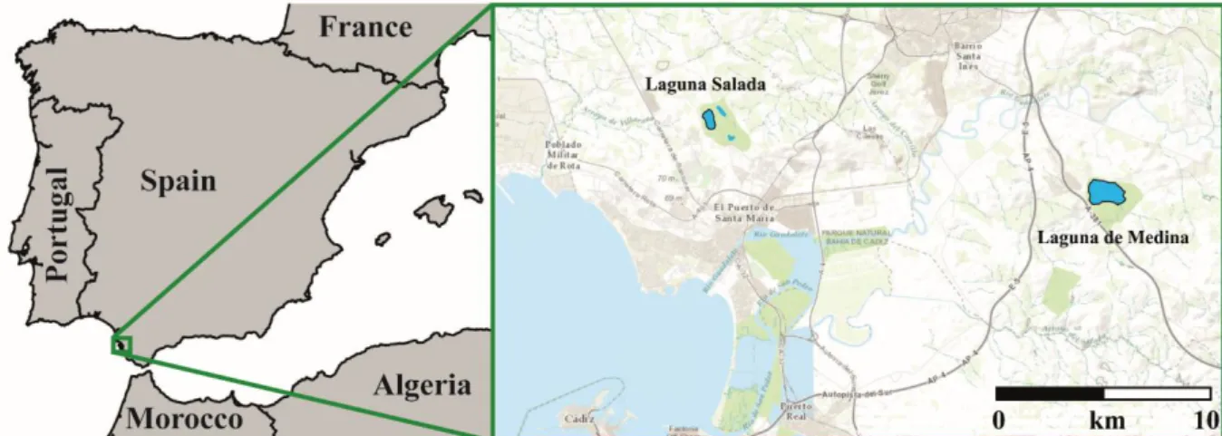
For a close collaboration between archaeologists and geologist, two lakes were selected closely situated to a cluster of Solutrean sites in the southern part of Spain. Laguna de Medina and Laguna Salada are both situated in the province of Cádiz, southern Spain (Fig. 1.3).
Laguna de Medina was already researched by Reed et al. (2001). This study shows the data of a 10.31 m long core, spanning the last 9,000 years. This record reflects the regional environmental and ecological changes, based on diatom data, supplemented with ostracods and pollen data. Extending this promising record would enhance the knowledge of the palaeoclimatic conditions of the Holocene.
Comparing the lacustrine data and combining these with the cultural data from the Solutrean sites gives insight in the impact of climatological and environmental forcing on the behaviour and dispersal processes.
Fig. 1.3: Distribution of the archaeological sites, geological archives, and the location of Laguna de Medina and Laguna Salada (red stars) on the Iberian Peninsula and Morocco. Shorelines are 100 m lower than today, matching the situation during the last glacial. After Kehl (2015)
24 1.3 Terrestrial palaeorecords in southern Spain
As has been shown before, the terrestrial conditions on the IP are important to refine climate models and to understand the context of human adaptation and climate. In the following chapter, the state of the art of the Holocene archives of palaeoclimate conditions is briefly summarized.
1.3.1 Lacustrine environments in Spain
Already in 1948, a total of 2,474 lakes were listed in Spain. About 3.2 % of these lakes are inland salt lakes (Pardo, 1948), occurring in the semiarid and arid zones (Comín and Alonso, 1988). The Guadalquivir region in southern Spain is one of the four main districts with saline lakes (Comín and Alonso, 1988). The establishment of the endorheic character in southern Spain can be dated back to the Miocene (Plans, 1969). Most of the depressions, situated in a karstic and evaporitic catchment, were established during the Late Pleistocene due to karstic processes as dissolution and collapse (Ibañez, 1973; 1975; Valero-Garcés et al., 2014).
In assessment of the lakes in southern Spain, during the 1940´s, the presence of 140 lakes was revealed, 17 of which are endorheic salt lakes (Dantín Cereceda, 1940). These lakes are mainly semi-permanent or temporary. Natural fluctuations result to desiccation in very arid years, or annual desiccation during summer (Alonso, 1998).
Now, almost 80 years later, several of these lakes are completely desiccated. The ongoing climate change extends the desiccated period, groundwater extraction results in complete desiccation, heavy use of agriculture increases soil erosion and silting up, and several lakes are even completely drained for agricultural purposes (Luque et al., 1999; García-Ruiz, 2010; IPCC, 2013a; Díaz-Paniagua and Aragonés, 2015). One of the most excessive examples is the drainage of Laguna de la Janda, in southern Spain. This lake, which had a surface area of around 87 km2, was drained in the 1930´s, and is now one of the biggest export areas for cotton and corn (Dantín Cereceda, 1940).
Deep lakes are suitable for reconstruction of the climate history by reflecting the past climatic, environmental and hydrological changes (Cohen, 2003). In Spain, and particularly in southern Spain, natural deep lakes do not frequently occur. However, small endorheic salt lakes (in Spanish: Lagunas) are common and present an alternative for deep lakes. These lakes are semi-permanent or temporal, with annual summer desiccation (Fig. 1.4). An advantage is, these lakes are highly sensitive to even small climate changes. The coring procedure on a desiccated lake is much easier than on a permanent lake, because of the accessibility. On the other hand, it can be a challenge to establish a good chronological control (Höbig et al., 2016) since desiccation events may result in hiatuses or the lack of organic matter (Chapter 3: Laguna Salada; Schröder et al., 2017).
The two lakes focused on in this thesis, Laguna de Medina and Laguna Salada, both in the province of Andalucía, show the differences between a semi-permanent lake (Laguna de Medina winter water depth: 3.2 m), which only dries out during very arid years, and a temporary lake (Laguna Salada winter water depth: 0.50 m) with annual summer desiccation.
Fig. 1.4: Example of a lake during an arid summer period. Picture is Laguna Salada (close to Cádiz, southern Spain) in September 2016)
25 1.3.2 Holocene palaeoclimate archives in (southern) Spain
The Holocene started about 11,700 cal years BP (Walker et al., 2009), and has been seen as a stable period for a long time. However, with the discovery of ice-rafted debris (IRD) in marine records (Bond et al., 1997), and in general the increase of high-resolution studies, short-term climate fluctuation became evident. It turned out, the Holocene climate is very dynamic, temperature and precipitation oscillations occurred mainly in southern Spain (Tarroso et al., 2016). The term rapid climate change (RCC) was introduced by Mayewski et al. (2004) for Holocene intervals with widespread evidence for climate change. The RCC´s are mainly based on the work of Denton and Karlén, (1973). Six periods of RCC are found during the Holocene: 9,000–8,000, 6,000–5,000, 4,200–3,800, 3,500–2,500, 1,200–
1,000, and 600–150 (Little Ice Age; LIA) yr cal BP. The RCC were all initiated by major changes in atmospheric circulation, polar cooling, and arid tropics, except for the LIA, which is reflected by polar cooling and humid tropics (Mayewski et al., 2004). Although the Holocene has a lot of RCC´s which are not fully understood, it is still often neglected in climate archives.
Southern Spain is very vulnerable to global climatic changes on centennial to millennial timescale (Giralt et al., 1999), and responds to the changes in global atmospheric patterns (Martín-Puertas et al., 2008). Numerous millennial-scale oscillations correlate with the Bond cycles, of which the onset, and end is linked to feedback fluctuations in oceanic, and atmospheric circulation, insolation, and vegetation cover (Bond et al., 1997; Gasse, 2000). The current moisture patterns are closely linked to the North Atlantic Oscillation index (NAO), which is calculated as the pressure differences between the Azores High and Icelandic Low (Hurrell, 1995). Research of a high-resolution record from SW Greenland recovered the NAO controlled the climate oscillations at least the last 5,200 years (Olsen et al., 2012).
Positive (negative) NAO values coincide with more arid (humid) conditions on the IP, and with cold (warm) temperatures over Greenland (Sánchez Goñi et al., 2002).
On the IP, several palaeoclimate studies were done in the last 50 years. Most of the terrestrial archives cover (partly) the Holocene, only a few penetrate into older sediments.
On the southern part of the IP, only a few terrestrial archives include the last glacial-interglacial cycle (Fig. 1.1). The Padul peat bog covers the last >54,000 years (Florschütz et al., 1971; Pons and Reille, 1988). This was the first record covering the complete postglacial vegetation history in a semi-arid region. The climatic fluctuations of the Holocene are of small amplitude. The Salines playa-lake focusses on the water availability of the last 70,000 years (Giralt et al., 1999). Both of the records have a poor age control for the Holocene. Comparison between the Padul peat bog and Salines playa lake resulted in a good correlation of the general trends in the Holocene. The Holocene is described as a humid period with some aridity crises at the beginning of the Holocene, the 8.2 ka event, and the middle Holocene, but the timing of the onset is questionable (Giralt and Juliá, 2003). The record from the Fuentillejo Maar includes the last 50,000 years. Some short cold and arid phases were found during the Holocene at 9,200-8,600, 7,500-7,000, and 5,500-5,000 cal yr BP, although the timing should be used with caution, because the age model of the Holocene is only based on two radiocarbon dates (Vegas et al., 2010). Laguna de Fuente de Piedra covers the last 28,000 years cal BP, and reflect the changes in facies in relation with climatological changes very well. However, this lake also deals with problems concerning the age model, the Holocene is only based on one radiocarbon date (Höbig et al., 2016).
The insufficient temporal resolution of the long palaeorecords disables comparison of RCC variability.
26 The age control of most of the short records for the Holocene is considerably better. Changes in palaeoclimate are reflected by vegetation dynamics, and lake level changes. The Holocene is divided into three periods.
The Early Holocene (prior to 8,000 cal yr BP) is characterized by a warm, dry and continental climate, reflected by low lake levels, and a transition towards steppe vegetation. In the lacustrine archives, this period is characterized by low lake levels or hypersaline conditions. Low lake levels are reconstructed in Lake Salines, SE Spain (Roca and Julià, 1997), Gallocanta Lake, NE Spain (Luzón et al., 2007), Portalet Lake, N Spain (González-Sampériz et al., 2006), Lake Siles, S Spain, (Carrion, 2002). In the La Mancha Plain, Central Spain, a transition towards more palustrine conditions coincides with a falling lake level (Dorado-Valiño et al., 2002) (Fig. 1.1).
From the palynological point of view, warm and dry conditions are found in the Guadiana Basin, S- Portugal, by the expansion of scrub and open-ground taxa (Fletcher et al., 2007). The same trend in visible in other Iberian pollen records, with the increase of xerophytes in the Segura Mountains, SE Spain (Carrion, 2002), steppe vegetation at San Rafael, SE Spain until 7,000 cal yr BP, (Pantaléon-Cano et al., 2003), a setback of arboreal vegetation and an increase in steppe vegetation in the La Mancha Plain, Central Spain, until 8,000 cal yr BP. In Villaverde, Central Spain, fire regime increases, (Carrión et al., 2001a), and in the Sierra de Estrela, Central Portugal, steppe to xerothermic forests occur until 8,700 cal yr BP (van der Knaap and van Leeuwen, 1995).
The Middle Holocene (roughly between 8,000-5,500 cal yr BP) represents the humid maximum, with a warm and moist oceanic climate, coinciding with the humid phase in the ´green´ Saharan desert (Gasse et al., 1990). This period is reflected by maximum lake levels, an expansion in vegetation cover and low fire activity (Carrión et al., 2010).
High lake levels are reconstructed in Gallocanta Lake around 8,100 (Luzón et al., 2007), Laguna de Medina between 6,320-4,800 cal yr BP based on diatoms (Reed et al., 2001), or between 8,000-6,700 cal yr BP based on stable isotopes (Roberts et al., 2008), and in Lake Siles between 7,400-5,300 cal yr BP (Carrion, 2002) (Fig. 1.1).
An increase in vegetation cover is found in San Rafael between 7,000-4,500 cal yr BP (Pantaléon-Cano et al., 2003), an increase in deciduous taxa and taxanomical diversity at the La Mancha Plain between 8,000-6,100 cal yr BP (Dorado-Valiño et al., 2002), a change from a xerothermic to mesothermic forest in the Sierra de Estrela, between 8,700-5,670 cal yr BP (van der Knaap and van Leeuwen, 1995). Forest expansion was observed in the Guadiana Basin between 9,130-4,920 cal yr BP (Fletcher et al., 2007), and an increase of Quercus in Villaverde between 7,350-5,900 cal yr BP (Carrión et al., 2001a).
The Late Holocene (onset between 5,500-4,500 cal yr BP) is a period of progressive aridification, although most of the archives show a complex evolution of several arid and humid intervals (Morellón et al., 2008). The onset of this arid period coincides with a change towards more positive NAO values (Sánchez Goñi et al., 2002; Moreno et al., 2012; Olsen et al., 2012).
Low lakelevels or periods of desiccation are found in Laguna de Medina (Reed et al., 2001), Gallocanta Lake (Luzón et al., 2007), Lake Estanya (Morellón et al., 2008), Lake Siles (Carrion, 2002), and Lake Zoñar, S Spain (Martín-Puertas et al., 2008) (Fig. 1.1).
Aridity trends are observed in pollen sequences in the Guadiana Basin by an expansion of shrublands (Fletcher et al., 2007), a transition towards steppe vegetation, and an increase in erosion in San Rafael (Pantaléon-Cano et al., 2003), an increase in steppe, and xerophytes in Villaverde, Sierra de Gádor and Sierra de Baza (Carrión et al., 2001a; 2003; 2007), a decline of arboreal vegetation at the La Mancha Plain (Dorado-Valiño et al., 2002), and an increase in steppe vegetation at the Padul peat bog (Pons and Reille, 1988).
27 1.4 Study sites
In the focus of the C3 project, two lakes were selected for palaeoclimate and -environmental reconstruction: Laguna de Medina and Laguna Salada, both in the province of Andalucía, southern Spain (Fig. 1.5).
The two lakes are a nature reserve since 1989, and protected by the Ramsar Convention on Wetland of International Importance (Ramsar, Iran, 1971), mainly because of their importance for nesting and overwintering water birds (Amat, 1984; Fernández-Palacios, 1990).
The province of Andalucía is influenced by a Mediterranean climate, characterized by moderate and relatively humid winters, controlled by the dominance of westerlies, bringing precipitation to the area.
The hot and arid summers are strongly controlled by the decreasing branch of the Hadley circulation, resulting in a rainfall minimum (Rodwell and Hoskins, 1996; 2001; Peel et al., 2007). The summer months have a five months water deficit (Paéz, 1991), significantly influencing the water table in the lakes, resulting in desiccation during (very) arid summers.
Fig. 1.5: Overview of the Iberian Peninsula and the locations of Laguna Salada and Laguna de Medina Laguna de Medina is a small endorheic lake with a maximum water depth of 3.5 m. Two parallel cores were retrieved in the deepest part of the lake from a floating platform during two field campaigns in September 2014 and March 2015. It resulted in a composite record of 25.65 m.
Laguna Salada is the biggest lake of the Complejo Endorreico del Puerto de Santa María, which consists furthermore of Laguna Chica and Laguna Juncosa. It is a semi-permanent endorheic lake with a maximum water level of 0.5 m. During the field campaign in September 2014, the lake was desiccated.
Two parallel cores were retrieved from the middle of the lake with a Cobra drill hammer. It resulted in a composite record of 12 m.
More detailed information about Laguna de Medina can be found in Chapters 2 and 3, and for Laguna Salada in Chapter 4.
The two selected lakes are only 20 km apart from each other. This gives the opportunity to compare the climatic signal of the two sites. This gives also insight whether the sedimentological units and the lithofacies are a climatic signal, or mainly influenced by the surrounding geology.
These lakes were selected, because they are situated close to the archaeological sites from the C cluster.
Next to that, the southern tip of Spain is not researched jet, except for one study by Reed et al. (2001).
Extending this study, will enhance the knowledge of the palaeoclimate of southern Spain.
28 1.5 Objectives
The research results presented in this thesis comprise two lacustrine sediment cores from southern Spain, Laguna de Medina and Laguna Salada, and the lake surface sediment, and soil catchment samples of Laguna de Medina. The aim of this thesis is to reconstruct the palaeoclimatological and –environmental settings for the Holocene.
Questions that arose during the three years of the Ph.D. are:
- How do the modern processes help to unravel the palaeoprocesses?
- How can we obtain a reliable age model?
- What are good proxies for such saline environments?
- Are the Holocene climate events synchronous in the two records, and how about the entire Iberian Peninsula?
This thesis includes the following manuscripts to address these questions:
Chapter 2: Modern sedimentation processes in Laguna de Medina, southern Spain, derived from lake surface sediment and catchment soil samples
This chapter comprises my first paper, which is already published in the Journal of Limnology. In this study, results from the lake surface sediment and soil catchment samples from Laguna de Medina are discussed. For a better understanding of past processes, it is important to distinguish how the modern processes function. For this purpose, 46 lake surface and 32 soil catchment samples were analysed with the same methods as for the long sediment sequence. Based on statistical analysis, mineralogical, geochemical, elemental, and granulometric compositions of the samples, the lake surface sediments can be divided into six provinces of individual composition and depositional processes, mainly based on the surrounding geology.
Chapter 3: A high-resolution Holocene palaeoclimate record from the Laguna de Medina, Cádiz, southern Spain
The palaeoclimatological results from the 25.65 m long record of Laguna de Medina are presented in Chapter 3. The multi-proxy approach provided a high-resolution record for the last 9,600 years. Based on the sedimentological, geochemical, mineralogical, and ecological (ostracods) data, reinforced with a statistical tool, the long-term palaeoclimatological and –hydrological evolution of the lake was reconstructed. The Early Holocene (9,600-7,870 cal yr BP) was an arid period, followed by a humid period, characterized by the maximum lake level between 7,870-5,780 cal yr BP. After this period, the prolonged aridification (5,780-3,750 cal yr BP) led to a decrease in lake level, although the lake level remains relatively high. The last ongoing aridification trend (from 3,750 cal yr BP on) results in a drastic decrease in the lake level with several desiccation periods.
Over this long-term trend, several periods of rapid climate change (RCC) resulted in short periods of aridification. Arid periods occurred between 9,160-7,870, 5,780-4,800, 3,150-2,420, 1,950-1,450 (corresponding to the RWP), and 1,264-550 (corresponding to the MCA) cal yr BP. The last RCC is a humid period, reflecting the Little Ice Age (550-170 cal yr BP).
The sequence of Laguna de Medina reinforces the connection between global changes in the hydrological regime, rapid climate change and NAO dynamics.
29 Chapter 4: A Holocene palaeoclimate record from the Laguna Salada, Cádiz, southern Spain
In this manuscript, the results from the 12 m long record from Laguna Salada are discussed. The multi- proxy study of this record represent the entire limnological history of the lake during the last 8,500 years.
Based on the geochemical, and granulometric data, three humid phases were recognized. The Mid- Holocene Optimum 8,500-5,900 cal yr BP, the Iberian Roman Humid Period (2,500-1,100 cal yr BP) and the Little Ice Age (750-250 cal yr BP). Three arid periods occurred, the Late Holocene aridification (5,900-2,500 cal yr BP), the Medieval Climate Anomaly (1,100-750 cal yr BP) and the modern period after the Little Ice Age (250 cal yr BP-now).
Chapter 5: Synthesis
The last chapter includes the synthesis based on the three manuscripts. The questions that arose during this thesis are answered and discussed.
30 Laguna de Medina by sunset
Picture by Ascelina Hasberg
31
Chapter 2
Modern sedimentation processes in Laguna
de Medina, southern Spain, derived from
lake surface and soil catchment samples
32
2 Modern sedimentation processes in Laguna de Medina, southern Spain, derived from lake surface sediment and catchment soil samples
Jasmijn van ´t Hoffa, Tabea Schröderb, Peter Helda, Stephan Opitzc, Bernd Wagnera, Klaus Reicherterb, Martin Mellesa
a Institute of Geology and Mineralogy, University of Cologne, Zülpicher Str. 49a, 506745 Cologne, Germany
b Institute of Neotectonics and Natural Hazards, RWTH Aachen University, Lochnerstr. 4-20, 52056 Aachen, Germany
c Institute of Geography, University of Cologne, Albertus Magnus Platz, 50923 Cologne, Germany Corresponding author: Jasmijn van ´t Hoff: jvanthof@uni-koeln.de
Institute of Geology and Mineralogy University of Cologne
Zülpicher Straße 49a 50674 Cologne, Germany
Key words: limnology, modern sedimentation patterns, Laguna de Medina, southern Spain,
Journal article (published), slightly changed
van ’t Hoff, J., Schröder, T., Held, P., Opitz, S., Wagner, B., Reicherter, K., and Melles, M. (2017).
Modern sedimentation processes in Laguna de Medina, southern Spain, derived from lake surface sediment and catchment soil samples. Journal of Limnology, 76(1), 103–115.
http://doi.org/10.4081/jlimnol.2016.1499
33 2.1 Abstract
Modern processes influencing sediment composition in the endorheic lake Laguna de Medina, southern Spain, are disentangled by the analysis of 46 lake surface sediment and 32 catchment soil samples. Based on statistical analysis of the mineralogical, geochemical, elemental, and granulometric compositions of all samples, the lake surface sediments can be divided into six provinces of individual composition and depositional processes.
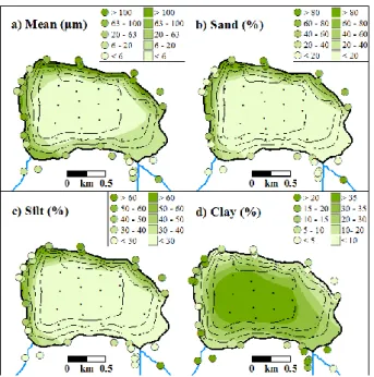
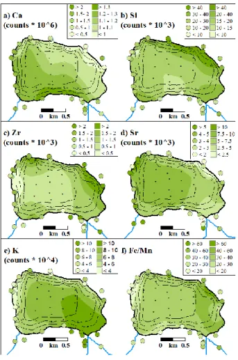
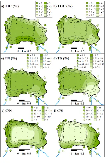
High quartz contents and coarse grain sizes, reflecting input from ancient terraces of the Guadalete River that are exposed in the adjacent hinterland, characterize the lake sedimentation close to the northern shore. At the southeastern shore, sedimentation is characterized by terrestrial input of the Triassic Keuper facies via the most important inlet, the Arroyo Fuente Bermeja, as reflected by high relative intensities of Ti, K, Al, Fe, Mg, and Rb. Sediments close to the southern shore are characterized by high calcite contents, reflecting predominant sediment supply from the adjacent Cretaceous ´capas rojas´, a series of Subbetic deep-water marlstones and limestones. Close to the western shore, relatively high gypsum contents presumably are due to precipitation from upwelling ground water. Anthropogenic influence is only indicated in the northwestern and central eastern parts of the lake, where the surface sediments are significantly enriched in TOC and TN, reflecting enhanced primary production due to terrestrial organic matter supply from anthropogenic areas in the respective catchment. The central part of the lake is characterized by distal hemipelagic sedimentation, with high concentrations of clay and silt and a chemical and mineralogical composition that reflects a mixture of the sediment sources characterizing individual parts of the lake shores.
The results of this study shed new light on the depositional processes and their potential spatial heterogeneity in small endorheic lakes. Furthermore, they will provide important information concerning the interpretation of the climate-controlled sedimentary processes through time, which are reflected in a 25.65 m long sediment record (Co1313) that was recovered in the lake centre in 2014 and 2015.
34 2.2 Introduction
Spain, especially the arid southern Spain, is very vulnerable to the ongoing climate change. For instance, the average air temperature rose 2-3 °C since the 1970´s (de Castro et al., 2004). The annual rainfall is reduced and droughts are increased since 1960 (Met Office, 2011). According to climate simulations, temperature over the next 30 years may rise another 1.1-1.2 °C during winter and 1.8-2.0 °C during summer, and precipitation may decrease by 7 to 9 mm month-1, leading to water stress for 25-60 % of Spain’s population (von Storch et al., 1993; Met Office, 2011; IPCC, 2013). Taking the more arid conditions of southern Spain, it can be expected that this region suffers more from water stress than the more humid northern Spain.
Comparatively little is known about the natural climatic variability in southern Spain on millennial timescales, beyond the range of meteorological measurements, and its impact on the regional environment. Such information is important to decipher the kind and rates of the spatial extend, magnitude, and temporal relationships of climatic forcing and environmental change. Most of the terrestrial archives only cover parts of the Holocene, have poor time resolution or age control, or are highly discontinuous (Reed et al., 2001; Fletcher et al., 2007; Martin-Puertas et al., 2008; Wolf and Faust, 2015). Only a few sediment cores, from the Padul peat bog and the Fuentillejo Maar, penetrate into sediments representing the Last Glacial Maximum (e.g., Pons and Reille, 1988; Vegas et al., 2010).
Consequently, our current understanding of the Late Pleistocene history of southern Spain, including its vegetation history, is predominantly based on data from marine sediment records, specifically from the Atlantic margin off Portugal (Voelker and de Abreu, 2011), the Gulf of Cádiz (Toucanne et al., 2007), and the Alboran Sea ( Martrat et al., 2014; Martinez-Ruiz et al., 2015). These records, however, integrate over large areas and thus lack sensitivity to detect the influence of climatic changes on regional scales.
One promising continental archive in southern Spain is the sediment record in the Laguna de Medina (Fig. 2.1). In this small endorheic lake, a 10 m sediment core was retrieved by Reed et al. (2001).
According to chronostratigraphic, lithological information and palaeoenvironmental reconstructions, these sediments were continuously deposited during the past 9,000 years and reflect the regional environmental change with a high sensitivity. In order to extend the record in time, and to provide more material for further analyses also in the upper part, the record in the central part of the Laguna de Medina (site Co1313) was extended to 25.65 m during two coring campaigns in September 2014 and March 2015.
For a better understanding of the core composition and its significance for past environmental and climatic settings, 46 lake surface sediment and 32 catchment soil samples were taken, and analysed for their mineralogical, geochemical, elemental, and granulometric composition. Here, we present the data obtained from the surface samples, and discuss them in the light of the modern sedimentation processes, mainly controlled by the surrounding geology, post-depositional processes, and anthropogenic influences.
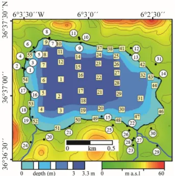
35 2.3 Study area
Laguna de Medina (36°37´04”N, 06°03´13”W) is an endorheic semi-permanent karst lake (Valero-Garcés et al., 2014) in southern Spain (Fig. 2.1), located roughly 12 km southeast of Jerez, 25 km northeast of Cádiz and about 3 km south of the river Rio Guadalete. This second largest inland salt lake of Andalucía is a nature reserve since 1987 (de Vicente et al., 2012). It is located 30 m above sea level (a.s.l.), the surface area amounts to 1.2 km2, and the catchment area to 16 km2 (Reed et al., 2001). At the southeastern shore, the most important inlet, the Arroyo Fuente Bermeja, enters the lake.
This is a temporary inflow, which is dry during summer months (Reed et al., 2001). In September 2014 and March 2015, the maximum water depths were 1.7 m and 3.2 m, and the salinities 6.0 PSU and 2.2 PSU, respectively.
The catchment of the Laguna de Medina (Fig. 2.2) is karstic and evaporitic (Durán Valsero et al., 2009), dominated by terrestrial Triassic claystones (Keuper facies), gypsum-rich evaporites, and marlstones (Paez, 1991). The inlet Arroyo de Fuente Bermejo predominantly drains the Triassic Keuper facies (claystones, sandstones, dolomites, and gypsum). Also the eastern area of the lake is dominated by Triassic units (IGME, 1984). In the north, remnants of alluvial terraces of Pleistocene sandstones and conglomerates of about 45 to 50 m a.s.l. demarcate the border of the lake. The southern area of the lake is characterized by the ´capas rojas´, a series of Subbetic deep-water marlstones and limestones (Vera and Molina, 1999). In the western catchment, Tertiary clays, marls, calcarenites, and biomicrites occur (IGME, 1984).
Figure 2.2: a) Geological map of the surroundings of Laguna de Medina, illustrating major stratigraphic units and fault systems (modified after IGME, 1984). The catchment area is encircled with a black line, the coring location of Co1313 is indicated by a red star. b) Legend for a).
Figure 2.1: Overview of the Iberian Peninsula showing the location of Laguna de Medina (red star
36 The lake was formed as a result of 20 to 25 m diapiric uplift (Rodriguez Vidal et al., 1993), initiated by the high vulnerability of Triassic and Tertiary marls to halokinetic deformation (Wolf et al., 2014). The appearance of diapirs started in the Upper Miocene and has been related to extensional or compressional tectonics in the Gulf of Cádiz (Medialdea et al., 2009). In the Middle Pleistocene, the Rio Guadalete left the elevated areas and found its way in the valleys. The ground water dropped below the karst base level, resulting in sinkholes and the prolapse of old sinkholes. Laguna de Medina is an example of renewed karst sinking in Triassic gypsums, formed in the Upper Pleistocene (Rodriguez Vidal et al., 1993;
Valero-Garcés et al., 2014). The modern configuration of the lake basin was probably established during the Late Pleistocene (Rodriguez Vidal et al., 1993).
Laguna de Medina today experiences a Mediterranean climate (Peel et al., 2007). During summer, average temperatures of 26°C occur and the precipitation is very low, with a five months period of water deficit. Meso-scale levanters, easterlies with velocities of 10-20 m/s, are frequent (Meteorological Office, 1962). The winters are characterized by an average temperature of 6°C and a relatively high precipitation of up to 90 mm per month (Paez, 1991). Both the levanters and the westerlies are weaker and less frequent than during summer (Dorman et al., 1995). The intensity and distribution of precipitation in the area is particularly influenced by the Azores High (Rodrigo et al., 2001) and by fluctuations of the North Atlantic Oscillation (Wolf et al., 2014). The mean annual precipitation is 525 mm, with a range of 250-975 mm (Paez, 1991).
The Laguna de Media is a shallow saline lake functioning as a hydrologically closed system (Fernández- Palacios, 1990). Nevertheless, there is a significant influence of ground-water inflow, which leads to the retention of water during summer times (Reed et al., 2001). The ground-water inflow is characterized by high salinities, due to dissolution of Triassic evaporites. This leads to a brine in the lake that consists of Ca-Na-Mg-Cl-SO4, resulting in gypsum precipitation (Eugster and Hardie, 1978). However, the groundwater infiltration is very low, due to little permeable underground (Fernández-Palacios, 1990), which makes the lake very vulnerable to variations in precipitation and evaporation. Today, the lake level is highly affected by the seasonal precipitation changes, resulting in summer desiccation in very arid years. Long-term studies from Furest and Toja (1984), Marazanof (1967), and Reed et al. (2001), and also the results from the two coring campaigns show a connection between lake level and salinity changes, especially after irrigation since 1948 (Tello Ripa and López Bermúdez, 1988). On the other hand, the relation between lake level and salinity is complex, because of re-dissolution of precipitated salts and gypsum, leading to an increase in salinity with an increasing lake level (Reed et al., 2001).
37 2.4 Material and methods
In March 2015, 46 surface sediment samples were taken from the uppermost 2 cm of the lake bottom (Fig. 2.3). The samples were retrieved from a rubber boat using a gravity corer with a plastic liner of 63 mm diameter (UWITEC Corp., Austria). The sampling location was noted in the moment the gravity corer hit the lake bottom. Sampling partly failed close to the northern shore, where coarse sand and gravel dominate.
The lake sediment sample set is complemented by 25 soil samples from the uppermost 5-10 cm in the catchment and 7 sediment samples from the Arroyo Fuente Bermeja, the only significant inlet. These samples were collected in September 2014 and March 2015.
Figure 2.3: Topographic map (green to red m a.s.l.) of the direct surroundings of Laguna de Medina, with the bathymetry (blue in m), and locations of lake surface (centre of squares) and catchment soil (black dots) samples.
The analytical work on the samples was conducted in the laboratories of the University of Cologne. In a first step, the total of 78 samples were freeze-dried, in order to exclude transformation of gypsum (CaSO4 · 2H2O) to bassanite (CaSO4 · ½H2O) or anhydrite (CaSO4), which would cause a weight loss of 20.91 % (Stern et al., 1989; Eswaran and Zi-Tong, 1991; Porta, 1998). Subsequently, the bulk sediment samples were split into aliquots for different measurements.
For the grain-size analyses, aliquots of the freeze-dried samples were pretreated with 10 ml NaCO3 at 60°C for 18 hours in order to remove gypsum (Stern et al., 1989). Subsequently, carbonate (10 ml 10 % HCl, 50°C, 3 h), organic matter (5 ml 30 % H2O2, 50°C, 18 h), and biogenic silica (5 ml 1 M NaOH, 90°C, 2 x 30 min) were removed. Between these steps, the samples were centrifuged and neutralized with deionized water. Before measurements, the samples were mixed with Na4P2O7 (0.05 %) and shaken for at least 12 hours to avoid flocculation of clay minerals. Each sample was measured three times in 116 classes in a range between 0.04 and 2000 µm using the Laser Particle Size Analyser LS 13320 (Beckman Coulter Corp.) and the Frauenhofer optical model. The grain-size distributions were calculated using the program GRADISTAT (Blott and Pye, 2001).
The aliquots for mineralogical and geochemical analyses were ground to <63 µm by hand in agate beakers. Bulk mineralogical contents were determined by X-ray diffraction (XRD) on powder pellets using a diffractometer Bruker D8 Discover with Cu tube (λ = 1.5418 A, 40 kV, 30 mA) and the detector LYNXE_XE (opening angle = 2.9464°). The spectrum from 5° to 90° was measured in 4155 steps of 1 sec. exposure time. The evaluation of the spectra to minerals was computed using Match! (Crystal Impact (2014), Bonn, Germany and SEARCH (Stoe and Cie (2003), Darmstadt, Germany) based on pdf2 (ICDD (2003), Philadelphia, USA). The evaluation of the concentration of the minerals was evaluated using TOPAS Rietveld (Coelho, 2003).
38 Relative element intensities were determined on pressed powder samples using an X-ray fluorescence (XRF) scanner (ITRAX; Cox Analytical Systems; Davies et al., 2015). Measurements were performed with 1 mm resolution and an exposure time of 60 s using a Cr-tube (settings: 50 kV, 38 mA), which provides a general overview of the elements lighter than Cr (Löwemark et al., 2011).
For the analyses of total inorganic carbon (TIC) and total organic carbon (TOC), ca. 35 mg samples were mixed with 10 g of distilled water and measured via the thermal catalytic oxidation principle in the Dimatoc 2000 (Dimatec Corp.). The contents of total nitrogen (TN) and total sulphur (TS) were measured with a vario Micro cube (Elementar Corp.), in which 5 mg samples were combusted at 1200
°C in a He and O2 flow and the element concentrations determined on the N2 and SO2 released by the thermal conductivity detector.
Interpolation and mapping of the data derived from the lake surface sediment and catchment soil samples were carried out by the ArcGIS software by ESRI using the Kriging method (Oliver and Webster, 1990;
Cressie, 1991). The principal component analysis (PCA) was conducted with PAST (Hammer et al., 2001).