• Keine Ergebnisse gefunden

Transformation of public space: social and spatial changes

N/A
N/A
Protected

Academic year: 2021

Aktie "Transformation of public space: social and spatial changes"

Copied!
170
0
0

Wird geladen.... (Jetzt Volltext ansehen)

Volltext

(1)

Transformation of Public Space: Social and Spatial Changes A Case Study of Yogyakarta Special Province, Indonesia

A dissertation submitted to the Faculty of Spatial Planning Technical University of Dortmund (TU Dortmund)

by

Dyah Widiyastuti April 2013

in fulfillment of the requirements for the degree of Dr. rer.pol.

(2)

ii

DOCTORAL COMMITTEE

Supervisor: Professor Dr.rer.pol Einhard Schmidt-Kallert TU Dortmund

Supervisor: Prof. Dr. Wolfgang Sonne TU Dortmund

Examiner: Professor Dr.-Ing. Sabine Baumgart TU Dortmund

Date of Defense: April 18, 2013

(3)

iii

ACKNOWLEDGEMENTS

I would like to express my gratitude and appreciation to all people who have been helpful in the completion of this thesis. The following thesis project would have been simply an Professor Dr.rer.pol. Einhard Schmidt-Kallert and Professor Wolfgang Sonne for their

I would also like to express my gratitude to my friends in Germany and my PhD colleagues from the peer review group for the wonderful experience and all the good times we had.

Special thanks to Kirsten Hackenbroch for her support in commenting on my work.

I would like to thank the DAAD (Deutscher Akademischer Austausch Dienst) for financially supporting my research. Without the support, it would be impossible for me to do all of this research.

would like to express my deepest gratitude to my dearest husband for listening and arduous task without their supports. First, I would like to thank my supervisors , advice, guidance, experience and knowledge they shared during the process.

Finally, and most importantly, I want to thank my family for their love and support. I

encouraging me to do my best. I am thankful for our son Abisatya. He brings his fresh

point of view to my life with thousands of spontaneous creative ideas and his joy.

(4)

iv

Preface

Yogyakarta is an old city where the palace of the king is the core from which the city grows.

It has traditional open square, called alun-alun, which takes form as a large void in front of the palace. The creation of alun-alun is closely related to the initial creation of the palace as the center of religious, political, and the military of Kasultanan Yogyakarta. Its spatial arrangement and diverse activities were centralized in the figure of the sultan and the initial functions of this space were strongly related to royal purposes which were not intended to public purposes. As the power shifted, alun-alun evolved with less emphasized on formal ceremony and ritual and has become merely a public space. This space has become a witness of changing power and political system in this old monarch as well as in the country. Changes in the role of the sultanate, the state, and civil society have reflected the impacts of the many different activities that define and redefine the characteristic and quality of this space. It has been experiencing various tensions over its reproduction ranging from issues of privatization, commercialization, preservation, and the absence of institution to the lack of planning and regulation. Taking all of these different aspects into consideration, it becomes an evident that alun-alun is part of controversy and renegotiation where various interests, meanings and values clash.

My thesis shows changing role and function of this public space through the dynamics of

cultural and historical changes by tracing its formation through time. The division of three

periods corresponds roughly to stages in the political development of Kasultanan

Yogyakarta which are the early establishment period, the early Indonesian independence

and the period of modern Indonesia. The attempts to discover what features and

important aspects of public space simultaneously focus on the design and physical

manifestation, consumption and use of space, management and control of space. The

exploration of emerging issues gives emphasis to the important values and meaning of

public space which has been reflected through its transformation processes. The research

has shown how unstable cultural, politic, and economy has produced and continues to

produce different uses of public space.

(5)

v

TABLE OF CONTENTS

Acknowledgments ………..

Preface ………

Table of Content………

List of Figures………...

List of Tables ………..

List of Abbreviations ……….

iii iv v viii ix x PART I – INTRODUCTION ……….. 1 Chapter I. BACKGROUND ……….

1.1. Motivation and Objectives ………..

1.2. Research Aims and Objectives ………..

1.3. Research Question ……….

1.4. Structure of the Thesis ………

1 1 2 2 3 Chapter 2. THE HISTORY OF YOGYAKARTA ……….

2.1. Kasultanan Yogyakarta and the Change of Political Regime ………

2.2. The Structure of Yogyakarta Urban Environment ………

2.2.1. The Javanese Conception of Order and the Relationship to Yogyakarta Spatial Structure……….

2.2.2. Symbolization ……….

2.2.3. The Cosmological Interpretation in the Origin Structure of Yogyakarta City ………

The Cardinal Direction and the Orientation to North-South ………

Spatial Organization by Hierarchy ………...

Caturgatra Tunggal as the Basic Component of the City ...

Kraton ……….

Concluding Remark on the Spatial Structure of Yogyakarta ……….

2.2.4. Land Administration System ………

Primary Land Distribution ……….

Land tenure System ………..

The Change of Regulation and Its Impact on Spatial Structure ………..

Concluding Remark on Land Distribution and tenure System in Yogyakarta ………

5 6 7 8 10 10 10 11 13 15 16 19 20 20 21 22 25 PART II CONCEPT AND METHOD ………. 26 Chapter 3. THE CONCEPT OF PUBLIC SPACE AND MEANING ……….

3.1. Understanding Public Space ………

3.1.1. Form of Public Space ………

3.1.2. Functions of Public Space ……….

3.1.3. Special Features of Public space ……….

3.2. Meaning in the Context of Built Environment ………

3.2.1. Space and Place ………

3.2.2. On Meaning ………

Process of Meaning ...

Meaning for Whom? ...

3.3. Important Notes of Public Space and Meaning ……….

3.4. Conceptual Framework for Understanding Public Space ………

3.4.1. Conceptual Framework ………..

Design and Physical Manifestation of Public Space ...

Consumption and use of space ...

Actor and Management ...

Context ...

3.4.2. Operational Elements and Detailed Research Questions ………

26

26

26

27

28

29

29

30

31

31

33

34

35

36

37

38

38

39

(6)

vi Chapter 4. RESEARCH DESIGN AND METHOD ………..

4.1. Research Strategy ………..

4.2. Selection of Study Area and Unit of Analysis ………..

4.3. Data Collection and Analysis ………..

4.3.1. Data collection ………

Literature and documents review ……….

Observation ………

Interview ……….

Challenges and limitation ……….

4.3.2. Data Analysis ………

4.4. Validity and Reliability ………....

4.5. Generalization ………..

41 41 41 43 43 44 45 48 51 52 55 55 PART III THE ROLE OF ALUN-ALUN ………. 56 Chapter 5. THE LEGACY OF MATARAM KINGDOM

: THE EARLY FORMATION OF ALUN-ALUN UNDER SULTANATE POWER ………

5.1. Kasultanan Yogyakarta and Dutch Political Shift ……….

5.1.1. Kasultanan Yogyakarta and VOC (1755 – 1800): The Early Establishment of Yogyakarta City ……….

5.1.2. Kasultanan Yogyakarta and Dutch Colonial Administration (1800-1940)

: The establishment of Colonial City ………..

5.1.3. The Demographic and Economic Context ……….

5.1.4. Concluding Remark o n the Dutch Political Shifts ………

5.2. The Role of alun-alun under VOC (1756-1800)………..…

5.2.1. Design and Physical Manifestation ………..

Southern alun-alun ………..

Northern alun-alun ………

5.2.2. Consumption and Use of Space ……….

Southern alun-alun ………

Northern alun-alun ………

5.2.3. Management and Control ………..

5.3. The Role of Alun-alun under the Dutch Colonial Administration (1800-1940) ………

5.3.1. Design and Physical Changes ……….……….

5.3.2. The Change of Consumption and Use ………

5.3.3. Management and Control ……….

5.4. Concluding Remark ………

56 56 57 59 60 62 62 62 63 65 71 71 71 74 75 75 78 79 80 Chapter 6. KASULTANAN YOGYAKARTA IN THE EARLY INDONESIAN INDEPENDENCE

: THE ROLE OF ALUN-ALUN IN THE POLITICAL TRANSITION FROM DUTCH COLONIAL

AUTHORITY TO REPUBLIC OF INDONESIA (1940-1989) ………..

6.1. Kasultanan Yogyakarta and the Political Shifts ………..

6.1.1. Kasultanan Yogyakarta and Sukarno’s Old Order………..

6.1.2. Kasultanan Yogyakarta and Suharto’s New Order……….

6.1.3. Demographic and Economic Context ……….

6.2. The Role of Alun-alun under Hamengkubuwono IX ………

6.2.1. Design and Physical Manifestation ………..

Southern alun-alun ………..

Northern alun-alun ………

6.2.2. Consumption and Use of Space ……….

Alun-alun under Sukarno’s Old Order ………..

Alun-alun under Suharto’s New Order ……….

6.2.3. Management and Control ……….

6.3. Concluding Remark ………..……….

81

81

81

83

83

85

85

85

86

88

88

90

92

92

(7)

vii Chapter 7. KASULTANAN YOGYAKARTA IN THE MODERN INDONESIA: THE ROLE OF ALUN-

ALUN IN THE CONTEMPORARY URBAN ENVIRONMENT ……….

7.1. Kasultanan Yogyakarta and the Dynamic of Indonesian Politic ………

7.1.1. Reformation and the End of Orde Baru ………..

7.1.2. Kasultanan Yogyakarta and Indonesian’ Post Reformation ……….

7.1.3. The Demographic and Economic Context ……….

7.2. The Role of Alun-Alun in the Contemporary Urban Environment ………..

7.2.1. Design and Physical Manifestation ………

Southern alun-alun ………..

Northern alun-alun ……….

7.2.2. Consumption and Use of Space ………

Everyday Life Practices ………..

Extra everyday Life Practices ……….

7.2.3. Management and Control over the Use of Alun-Alun………

Actors and organization ………

Examples of management ………..

7.3. Concluding Remark ………..

94 94 94 95 95 97 97 97 100 107 107 118 126 126 128 133 Chapter 8. CONCLUSION: TRANSFORMATION OF PUBLIC SPACE ……….

8.1. The Element Experienced Transformation in Alun-Alun ………

8.1.1. Design and Physical Manifestation ………

8.1.2. Consumption and Use of Space ………

8.1.3. Management and Control ………

8.2. Summarizing the Transformation Process of Alun-alun ………

134 134 134 138 140 141 PART IV IMPLICATION AND RECOMMENDATION ………. 146 Chapter 9. TRANSFORMATION OF PUBLIC SPACE: HOW TO CREATE A GOOD PUBLIC SPACE

AND ENTRY POINTS FOR URBAN PLANNING ………

9.1. How to Create a Good Public Space: Notes from the Main Findings ………..

9.2. Entry Points for Urban Planning ………...

9.3. Reflection on Methodology ……….

9.4. Area for Further Research ……….

146

146

147

148

150

REFERENCES ……….. 149

ANNEXES ………. 155

(8)

viii

LIST OF FIGURES Figure 1-1.

Figure 2-1.

Figure 2-2.

Figure 2-3.

Figure 2-4.

Figure 2-5.

Figure 2-6.

Figure 2-7.

Figure 3-1.

Figure 3-2.

Figure 4-1.

Figure 4-2.

Figure 5-1.

Figure 5-2.

Figure 5-3.

Figure 5-4.

Figure 5-5.

Figure 5-6.

Figure 5-7.

Figure 5-8.

Figure 5-9.

Figure 5-10.

Figure 5-11.

Figure 5-12.

Figure 5-13.

Figure 6-1.

Figure 6-2.

Figure 6-3.

Figure 6-4.

Figure 6-5.

Figure 6-6.

Figure 6-7.

Figure 6-8.

Figure 7-1.

Figure 7-2.

Figure 7-3.

Figure 7-4.

Figure 7-5.

Figure 7-6.

Figure 7-7.

Figure 7-8.

Figure 7-9.

Figure 7-10.

Figure 7-11.

Figure 7-12.

Figure 7-13.

Figure 7-14.

Structure of the thesis ………

The change of political regime in Yogyakarta ………

Diagram of south and north city axis ………..………

The social structure of society analog to spatial hierarchy of Yogyakarta ………

Caturgatra Tunggal as the main structure of the city and accelerator of urban growth ………

The plan of kraton showing alun-alun, wall, and the main buildings ………

Pictures of kraton Yogyakarta ………

Land tenure system in Yogyakarta ……….

Social space relationship ………..

Conceptual framework for understanding the production of public space ……

The setting of observation ………..

The characteristic of respondent from user groups ………..

Spatial arrangement of inner city wall, where both alun-alun were located in enclosed area ...

The population composition of Yogyakarta City year 1920- 1930 ………

Southern alun-alun on the first period ………

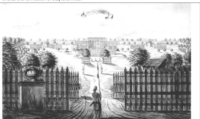
View of the Yogyakarta kraton from the northern square (alun-alun) sketched by A. de Nelly, one of Johannes Rach’s pupils, in circa 1771 ………..

Banyan trees in northern alun-alun ………..

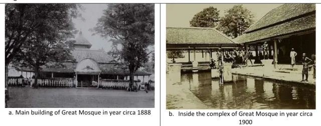
The Great Mosque ………

Northern alun-alun on the first period ………

Garebeg procession in northern alun-alun Yogyakarta ………..

Illustration of rampogan by J.C. Rappard ……….

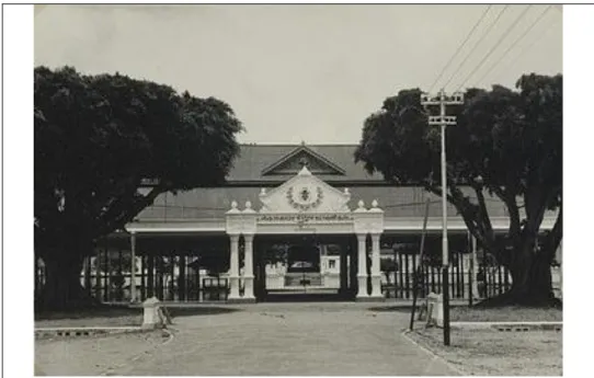
Pagelaran hall of kraton Yogyakarta in year 1939 - A mix of steel-concrete construction and traditional ornamentations ………

Museum Sono Budoyo ………

Fenced banyan trees and the main entrance of southern alun-alun in year circa 1920……….

Movement of people across northern alun-alun in year circa 1935 ………

The Population of Yogyakarta City year 1930-1990 ………..

Yogyakarta City population by ethnicity in year 1980 ……….

The spatial arrangement of southern alun-alun in 1980 ………

Building surrounding northern alun-alun in 1986 ………..

Northern alun-alun in year 1986 ……….

Indonesian national movements in northern alun-alun in year 1946 ………..

Southern alun-alun was used for scouting activities in year circa 1950 ………….

Various activities in northern alun-alun in year 1986 ………..

The population of Yogyakarta City in 1980-2025 ……….

Yogyakarta City population by age in year 2010 ……….

The number of tourist visited Yogyakarta in year 2006-2010 ………

Entrance of southern alun-alun ………..

The fenced banyan trees and buildings in southern alun-alun………

Street and lawn square in Southern Alun-alun………..

Buildings on the east edge of northern alun-alun ………..

Buildings on the north edge of northern alun-alun ………

Buildings on the west edge of northern alun-alun ……….

Buildings on the south edge of northern alun-alun ………..

Southern alun-alun was changed into a football field during the competition..

Various types of street vendor on northern alun-alun ………

The physical appearances of street vendor in northern alun-alun during the day……….

The celebration of New Year’s Eve in southern alun-alun……….

4

7

11

14

15

18

19

24

32

36

46

51

58

61

64

66

67

68

70

72

74

76

77

78

79

83

84

86

87

87

88

90

91

95

96

97

97

98

99

102

103

104

105

110

114

116

119

(9)

ix Figure 7-15.

Figure7-16.

Figure 7-17.

Figure 7-18.

Figure 7-19.

Figure 8-1.

Figure 8-2.

Figure 8-3.

Northern alun-alun was changed into a bazaar during sekaten night fair……….

The oration of Hamengkubuwono IX in front of bangsal pagelaran in

northern alun-alun to support Indonesian political reformation ………

Pisowanan agung in December 13, 2010 demanding the special status of Yogyakarta region ……….………

Massive praying to celebrate Mulud………....

The space arrangement for food vendor in southern alun-alun ………..

Physical changes of southern alun-alun from 1756 to 2012 ………

Physical changes of northern alun-alun from 1756 to 2012 ………

Transformation of alun-alun from 1756 to 2012 ……….

122 124 124 125 132 135 136 144

LIST OF TABLES Table 4-1.

Table 4-2.

Table 4-3.

Table 4-4.

Table 5-1.

Table 5-2.

Table 5-3.

Table 6-1.

Table 7-1.

Table 7-2.

Table 7-3.

Table 7-4.

Table 7-5.

Table 8-1.

Table 8-2.

Table 8-3

Source of evidences for present and historical data ………..

The list of key informants ………..

Composite group of respondents ……….

Selection of research tools ………

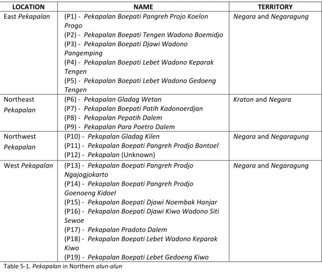
Pekapalan in Northern alun-alun ……….

Royal servants who responsible for maintaining alun-alun ………..

The characteristic of alun-alun during the first period ……….

Characteristic of public space through changing administration system ………

Street vending in northern alun-alun ………

Street vending in southern alun-alun ………

The Role of Certain city government agencies with regard to alun-alun …………...

Overview of City Bylaws with regard to alun-alun………

Overview of alun-alun on the contemporary urban environment ………...

Overview on the elements of form that experienced changes in alun-alun ……….

Overview of the intensity of various activities in alun-alun ………..

Overview of the role of various actors in the control over alun-alun………..

44

49

50

54

69

75

80

93

115

118

127

127

133

137

138

140

(10)

x

LIST OF ABBREVIATIONS

APBD : Anggaran Pendapatan dan Belanja Daerah; Local Budget of Revenue and Expenditure

APBN : Anggaran Pendapatan dan Belanja Nasional; National Budget of Revenue and Expenditure

Bappeda : Badan Perencanaan Pembangunan Daerah. Regional Development Planning Board

BPS : Badan Pusat Statistik. Statistics Indonesia

IDR : Indonesian Rupiah. The currency of Indonesia. 1 rupiah  0,00008 EUR IMB : Ijin Mendirikan Bangunan. Building construction permit

KNPI : Komite Nasional Pemuda Indonesia, a state organization for young people related to social and sport activities.

MUI : Majelis Ulama Indonesia, a national Islam religious organization

PDHI : Persatuan Djamaah Haji Indonesia. A social organization of Indonesian Hajj PMPS : Pasar Malam Perayaan Sekaten; the night market and festival of sekaten.

It refers to an organizing committee set up by city government to manage sekaten night fair.

Pramuka : Praja Muda Karana, an Indonesian scout

RPJMD : Rancangan Pembangunan Jangka Panjang. Draft of Yogyakarta City Long Term Development Plan

RRI : Radio Republik Indonesia, an Indonesian state radio network

RT : Rukun Tetangga, a neighborhood association which consist of several households

RW : Rukun Warga, a local neighborhood association which consist of several RT SD : Sekolah Dasar, elementary school for children in the age of 7-12 year old.

TVRI : Televisi Republik Indonesia, an Indonesian state television station

VOC : Vereenigde Oost-Indische Compagnie, the Dutch East India Company

WIT : Western Indonesian Time

(11)

1

Chapter 1

INTRODUCTION

1.1. Motivation and Relevance of the Research Problem

As my academic interest in public space became the basis of my research, I came to appreciate the academic value of my concern about the public space in Yogyakarta. In recent years there has been considerable and growing interest among academics worldwide concerning the role of public spaces in urban life. Works coming from various disciplines such geography, planning, architecture, anthropology and cultural studies have tried to define and explore that role and understand current changes and their consequences. The work of Stephen Carr (2009) explores public space and its support by examining the origins and realities of public space. Madanipour (2010) analyses the process of urban design to explore the changing character and accessibility surrounding the tension of making public space. As various scholars (Gehl 1996, Carr 1992, among others) found the dynamics of public space in many places, the aesthetic, political, and social aspects of public space in Yogyakarta are dynamic and change continually in response to personal action and broader socio-political influences. Through discussion they also contested the design, use, and meaning of the space. Changes in the roles of the state and civil society, of government and the governed have reflected the impacts of the many different activities that constantly define and redefine the characteristic and quality of public space. I became interested especially on the contrast between the present condition and real experiences told by friends and families, with the ideal description of traditional public space in the past. It is this duality between contrasting memories that form the prism through which I wish to examine the long and complex history of the existing square in Yogyakarta.

Yogyakarta, my hometown, is an old city where the kraton (palace of the king) is the core from which the city grows. It has two open squares called alun-alun with two banyan trees in the center while the lines of trees containing religious messages were planted in these courtyards. The creation of those spaces as described by scholars like Santoso, Ikaputra and Woodward, is closely related to the initial creation of kraton as the center of religious, political, and the military of Kasultanan Yogyakarta. The space functioned as an arena delivering opinions and demands to the authorities, for public activities sponsored by the ruler, and for religious ceremonies to celebrate the ruling power of the king (Handinoto 1992). Through its spatial arrangement and diverse activities centralized in the figure of the sultan, alun-alun gained its centrality as a symbol of sultan power upon his subjects (Santoso 1984). Despite the strong presence of the dominant power, historically the alun- alun was central to both the physical and the cultural lives of its people although mostly symbolic (Lim 2006).

The description above illustrates an ideal image alun-alun as a sacred and well-ordered

space which nowadays however does not correspond with current conditions. The center

of this square is used for parking, the trees are old and decaying, while surrounding

buildings have not been well maintained. The intense uses for vending activities are most

prominent and occupying any available part of alun-alun be it on the sidewalks, unutilized

(12)

2

buildings, or around the twin banyan trees. The encroachment of space and resultant congestion are the common problem resulting from vending activities. Not only do the street vendors take up physical space but they also contribute negatively to the physical appearance of alun-alun. On the other hand, this vending activity provides much needed income for certain groups of people. It also provides an alternative of affordable goods for larger group of people. Although contributing to the economy of the city, street vendors are seen as a problem (Yatmo, 2008) which led to the desire to revitalize alun-alun. When the city government came up with a plan to redevelop alun-alun to construct underground parking in the 2000s, diverse groups of people raised various objections. Those who were concerned with functionality saw it as a positive effort, while other groups whose concern was for its symbolic value and were emotionally attached to alun-alun responded negatively to this plan. The various arguments surrounding this plan have shown that the alun-alun is part of controversy and renegotiation where various interests, meanings and values clash.

1.2. Research Aims and Objectives

The research problem discussed above reveals that there has been a growing demand and resurgence in the use of alun-alun. Given that public space is produced and reproduced through the dynamics of cultural and historical changes, understanding this kind of public space is best made by tracing its formation through time. The above discussion indicates the three topics that provide the main basis for this research, namely physical design, use, and actors. Accordingly the main objective in starting this research is to explore and to analyze the importance of public space in urban life. In line with this, the detailed objectives of the research are:

• The research tries to focus attention on the importance of learning from the production of public spaces and how it has been used in order to know how the existing public space could be best utilized and organized.

• To examine the transformation process of traditional public spaces by describing and analyzing how applied planning concepts, strategies, socio-cultural aspects and actors have influenced the transformation of the public space and how this in turn changes how it is used.

• To explore the specific values of public space through social and spatial changes of traditional public space in Yogyakarta Special Province

1.3. Research Questions

Public space is the setting for everyday urban life where daily interactions, economic

exchanges, and informal conversation take place, thereby creating a meaningful place in

the heart of the city. This meaning is marked by the physical transformation of alun-alun

and perhaps highlights what Stephen Carr asserted that public space does not decline but it

simply take a new form. By simultaneously focusing on the physical characteristics, land

uses and actors in the present context, this research attempts to discover what features

and important aspects of public space have made it meaningful for society. The aim to

understand the key issues for contemporary public space leads to the formulation of three

main research questions, as follow:

(13)

3

1. What are the values and meanings behind the use of public space?

2. How have these values been translated into spatial form and how did they change the spatial arrangement of pubic space?

3. How do and did these values influence the decision-making at different levels on the use and management of the public space?

1.4. Structure of the Thesis

The structure of this research thesis aims to gradually understand the evolution of public space by taking the example of traditional public space in Yogyakarta and it is structured into four parts and nine chapters. An overview of the structure is provided in Figure 1-1.

Part I: Introduction consists of two chapters which provide an introduction to the research and its context. Chapter 1 gives an overview of the objectives, the research questions and the structure of the thesis. Chapter 2 outlines the development of the city from its early establishment to the present with emphasis on the structure of the city. The different stages of city development become the basis for understanding the role of public space respectively.

Part II: Knowledge Base and Method begins with discussion of the most relevant theoretical departures on the concept of public space and explores issues surrounding its inherent complexity. The intention here is to draw from a range of literature to establish the key tensions of public space discourse. Based on these considerations, the conceptual framework and operational terms are outlined in chapter 3. Chapter 4 contains justification of the research design and methods used to structure the research through data collection and analysis processes.

Part III: The Empirical Study consists of four chapters which provide the empirical parts of the research by tracing the transformation of alun-alun as a public space. Chapter 5 provides the historical role of alun-alun during the early establishment of Kasultanan Yogyakarta until the late period of Dutch Colonial Administration. Chapter 6 deals with the role of alun-alun after the period of Indonesian independence, while chapter 7 discusses alun-alun in its present context. Chapter 8 evaluates the transformation process of public space and explores emerging issue during its evolution. It gives emphasis to the important values and meaning of public space which has been reflected through its transformation processes. It establishes the connection between these issues and the contestation of public spaces.

Part IV: Implication and Recommendation is where the implication and recommendations

are provided. It discusses the important notes from the main findings and provides entry

points to utilize the outcome of this research in urban planning.

(14)

4

Figure 1-1. Structure of the thesis

(15)

5

Chapter 2

THE HISTORY OF YOGYAKARTA

Yogyakarta once was territory under Mataram Islam, a kingdom which ruled Great Central Java from 1570 1 to 1755 (Andrisijanti 2000). The term ‘Mataram’ refers to the area in which the kingdom was located, while Islam is used by scholars to differentiate this 16 th century kingdom with the previous Hindu-Buddhist kingdom which flourished in this area between the 8 th and 10 th centuries (Poesponegoro & Susanto 2008). Mataram was the region which produced the most powerful and the longest of modern Javanese dynasties. The capital city of Mataram Kingdom had moved several times, first in Pajang (1568), Kotagedhe (1586), Plered (1625), Kartasura, and then in Surakarta (1743) and Yogyakarta (1755) (Ricklefs 2001, Santoso 2008). When the Dutch first reached Java at the end of the sixteenth century, Mataram was already a major and expanding power in the region (Ricklefs 2001).

Mataram Islam Kingdom is considered to have been independent for about 170 years, before it was officially under VOC 2 ’ rule in 1740 who intervened in the political conflict by providing military support. In this way, the Dutch could maintain their colonial power through political control although the major intention of VOC was economic exploitation focused on the supply of certain agricultural products (Kartodirdjo 1974).

The establishment of Yogyakarta is the result of the Javanese War succession, began with a conflict between Sunan Pakubuwono II (the ruler of Surakarta) and his brother Mangkubumi, the civil war, Dutch involvement, and ended with the Treaty of Giyanti signed on 13 February 1755. The treaty divided Mataram Kingdom between rival claimants to the throne into Surakarta on the eastern part and Yogyakarta on the western part. Surakarta was ruled by Pakubuwono III and he took the old Mataram palace in Surakarta as the center of his kingdom, while Prince Mangkubumi built his new palace and became the first ruler of Yogyakarta adopting the name of Hamengkubuwono I. Dutch extended intervention was both a consequence and cause of the continuing disintegration of the Javanese state, once the most powerful empire of the archipelago (Ricklefs 1986). The empire of Mataram finally disappeared in 1755, when its remaining territory was shared by the Dutch between the rulers of Surakarta and Yogyakarta. With the demise of the larger and wealthier Surakarta,failing to foresee the ultimate success of the revolutionary movement it threw its lot in with the Dutch and Yogyakarta became the sole heir to the legacies of the old Javanese Empire.

1 The establishment of Mataram Islam is counted from the development of its palace at Kotagedhe around 1970s.

2 Vereenigde Oost-Indische Compagnie, VOC, is the Dutch East India Company.

(16)

6

2.1. Kasultanan Yogyakarta and the Change of Political Regime

Kasultanan Yogyakarta, since its earliest creation, has experienced fundamental political transition. During those transitions, Kasultanan Yogyakarta survived as a viable political entity. It was a vorstelanden under the Dutch Colonial system which left sultan and kraton compound untouched. After unification with the Republic Indonesia, it continues to hold special status and maintains the authority of the royal system. The dynamic of Yogyakarta urban development continued in accordance with changes in political, social and economic along the various periods. The role of the sultan in dealing with supreme authorities is central to determine the significance and relevance of Kasultanan Yogyakarta in a broader context.

Yogyakarta is an array of hybridities in which pre-colonial, colonial, and post-colonial Java and Indonesia all figure significantly. In the study of Yogyakarta city, two phases of historical layers, the colonial and the modern periods are often distinguished. This common periodization is based on the significant political power shifting from a traditional independent Javanese empire into a region under the reign of colonial European, mainly Dutch and British, and finally the unification of Yogyakarta into the integrated Republic of Indonesia after a short period of Japanese occupation. Among the relevant features of Javanese and Indonesian political history that figure significantly is the unique political position of Yogyakarta as a kingdom under the Dutch Colonial era and within the Republic of Indonesia and what is understood by Indonesians as a distinction among the three major eras of their common history: the Orde Lama (Old Order) of the first Indonesian’s president Soekarno (1945-1966), the Orde Baru (New Order) of the second president Suharto (1966- 1998), and the Orde Reformasi (Reformation Order, 1998-present).

The sultan judicial authority was eroded during the colonial era, to the point where only

the territory within the kraton wall was subject to even limited royal jurisdiction and was

eliminated with the establishment of the Indonesian Republic. Although Yogyakarta holds

status as an independent ‘state under state’ since its early establishment, the role of the

reigning king is significant in dealing with main authorities. Hence in the study of the

transformation of public space along with the development of Yogyakarta city this could be

best understood from the shifting internal reigning ruler. It therefore seems more realistic

to create periodization based on the prevailing figure of reigning kings in Kasultanan

Yogyakarta along with their political strategy as it corresponded to dominant authorities.

(17)

7 Figure 2-1. The change of political regime in Yogyakarta

Source: Author’s construct based on Soemardjan (2009)

For this research purposes, the years from 1755 to 2012 are divided into three periods corresponding roughly to stages in the political development of Kasultanan Yogyakarta as well as the Indonesian Republic (Figure 2-1). The first is the early establishment period (1755-1940), beginning with the establishment of Kasultanan Yogyakarta and ending with the last years of Dutch sovereignty. It relates to the origin of Yogyakarta city which, for the most part, is rooted in the earliest phase in indigenous center during the reign of Hamengkubuwono I to Hamengkubuwono VIII (1755 – 1940). The second period (1945- 1989) is the early Indonesian independence, which includes the transfer of sovereignty from the Netherland, beginning with the Japanese occupation, and the proclamation of Indonesian independence to the Indonesian New Order. It is characterized by a struggle among the political forces concerning the best way to achieve political independence:

either by negotiation or confrontation. The third is the period of modern Indonesia. The term modern as the most recent period is used to characterize the development of Yogyakarta city under the independent Republic of Indonesia. Since independence Yogyakarta has grown tremendously, and so have the cities both in number and in number of inhabitants. In the wake of economic development, major city problems have appeared.

The exposure to foreign influences and the struggle between different ethnic and religious groups to gain the upper hand in the city have been significant factors in the development of the city. All of the changes are reflected in the transformation of public spaces, as the subject of this study.

2.2. The Structure of Yogyakarta’s Urban Environment

In understanding the structure of urban environment, it is appropriate to begin with a discourse on the creation of order. Human creates order (cosmos) out of the primeval disorder (chaos) through classification, the imposition and articulation of various underlying principles. The attempt to reduce the apparent randomness of the universe to a sense of order is grounded in assumptions about nature which have shaped the relationship between knowledge and power in a particular way. This relationship involved a synthesis of the `latest' technology and of religious belief in the service of state domination.

Hence the creation of order is also the construction of cosmology as the central concept of

(18)

8

order, which has been a feature of all human societies (Eliade 1959).Through cosmology people treat the universe as organized rather than as a collection of random components.

2.2.1. The Javanese Conception of Order and the Relationship to Yogyakarta Spatial Structure

The Javanese conception of order, as it developed and crystallized mainly during the period of Hinduized Kingdoms in the 11-16 th centuries has mixed with other influences (Geertz 1980). Historical literature in the early Southeast Asian history has been overwhelmingly concerned with the religious and philosophical conception underlay and thus shaped Southeast Asian in state and kingship (Heine-Geldern 1942) as well as the Indianization states which formed certain discourses entailing concepts of Hindu-Buddhist civilization.

Other scholars, like Woodward, argue that the basic conception is derived from Islam. He notes that the Javanese conception of kingship and piety is based on the local interpretation of revelation and miracle in Islamic concept (Woodward 2011). The fact that Islam became the basic foundation in the early establishment of Kasultanan Yogyakarta as one of the heirs to previous Mataram Islam Kingdom, has made this religion show major roles among many influences. This does not simply imply, however, that it is peculiarly Islam. Many other elements derive historically from the influence of Indic civilization and others have parallel in a wide range of Javanese traditional cultures. Scholars like (1980), Behrends (1989) and Anderson (1972) believe that Javanese cosmology derived from various influences which form a unique blend. It is related to the previous influences as a

‘unique amalgam’ or ‘eclectic blend’ of Hindu, Buddhist, Islamic and indigenous Javanese elements (Helman 1988, Anderson 1972).

Javanese believe that human order was brought into being as the creation of the world.

The creation of order is to deal with the interrelationship between human and cosmos, between social and the cosmic realm. Therefore, the creation of a place or habitat is always a consecration which represents the work of God. The pattern of the city mostly duplicated a celestial archetype, which reflected Cosmo-magical power. The primary notion we shall deal with is the concept of macrocosms-microcosms. The Javanese believe in the parallelism between macrocosm and microcosm, between jagad gedhe and jagad cilik, between universe and the world of human being as an orderly harmonious systematic world. It views the universe as the wholeness which is balanced and harmonious, inseparable one from another, and always interconnected. It emphasizes the need to maintain a cosmic equilibrium, since macrocosm and the microcosm are not always stable, and the instability in the macrocosm is the result of incident made in microcosm, or vice versa.

The idea of unity and harmony in the Javanese conception of order constituted

emphasizing immanency of the sacred world. The representation of cosmological concept

gave ideas of divine kingship and it was conceived in various ways to dominant religion

(Heine-Geldern 1942). In the case of the sultan, the ruler was not the representative of the

divine, but the divine itself where the power from the universe was concentrated in the

figure of the Sultan. The king represents the Devaraja, the God King, where a king is the

manifestation of the divine power. Some scholars see the equation of kingship and

(19)

9

sainthood from the theory of kasekten (power), the dynastic myths linking Yogyakarta with older Javanese states and the perspective of Sufi theory of ‘Perfect Man’ (Geertz 1980, Anderson 1972, Woodward 2011). A king was thought to be endowed with majesty in the form of supernatural power from the pusaka 3 (royal regalia) and his position was bolstered by symbolism and ritual, some of it is indigenous, while others are influences of Hindu and Islam. A king of Kasultanan Yogyakarta has the royal title Sampeyan Dalem Ingkang Sinuwun Kangjeng Sri Sultan Hamengku Buwono Senapati ing Ngalaga Ngabdurrokhman Sayidin Panatagama Khalifatullah. A king is believed to be chosen by God and to be blessed by wahyu (A., revelation), a divine radiance which glows to all of his people. He is believed to have the ability to establish union with God which makes him a Khalifatullah or a representative of God in the world and gives guidance to his people and subjects. He has the ability to establish a mystical union with God, which is called ‘manunggalling kawulo Gusti’ or ‘union of servants and God’. The Sultan is also the servant of God and the lord of the state. This relationship is stated in his royal title: Ngabdurahman (‘servant of the merciful’) and Hamengkubuwono which literally means a person who holds the world on his lap as ‘a lord of the world’. In his capacity as Panatagama (‘regulator of religion’) and Senapati ing Ngalaga, he has power as a supreme commander and the Sultan must defend the Shari’ah (Islamic law). People believe a king and his power are able to maintain the harmony between empire and universe to provide tranquility and prosperity of the state.

The manifestation of a transcendental element is translated into a microcosm of the center which serves as a communication link between heaven and earth. It is the axis mundi following the terminology of Eliade. The harmony, unity and continuity between jagad cilik (microcosm) and jagad gedhe (macrocosm) is achieved by organizing the empire as an image of the universe, as an imago mundi, a universe itself on a smaller scale. Spatially it is translated in the form of kraton. The architecture of kraton is a representation of axis mundi, which is made possible by the fact that the sultan, is equated with the pillar of the universe. This is what Geertz (1980:2) states as ‘exemplary center’: “… This is the theory that the court and capital is at once a microcosm of the supernatural order. ... The universe on a smaller scale and the material embodiment of political order. It is not just the nucleus, the engine, or the pivot of the state, it is the state”.

Kraton and the sultan are constituted as the model for socio-spatial order, converged in the concepts of divine kingship and exemplary center which served as a legitimizing device for the ruling Javanese elites. It was a process which formed a certain discourse of power entailing concepts about relationships between leaders and followers and about ways of representing and organizing the state. Kraton stood for the whole empire. It was more than the center of politic and culture, it was the mystical center of empire which explained the magical relationship between empire and universe. Therefore, the model upon which the order to be represented was the political center, the ritual display of power, and more

3 The fertility and well-being of the empire was a reflection of the spiritual power of the king and his royal

regalia. Warfare to fight over the reign, usually among princes, was to sack the capital and destroy the sacred

center. A person who held royal regalia then could establish his own capital and sacred center (Anderson

1972, Woodward 2011).

(20)

10

specifically the kraton with the sultan as the center in which the sacred was embedded. All were designed to mediate the relationship between the macrocosm and microcosm worlds, to create harmony and unity. Furthermore, cosmology as the central concept of order could be interpreted for both social and spatial ordering, since it even appears much more deeply embedded in the practicalities of people’s everyday lives (Herzfeld 2001). It is translated in the spatial arrangement of the city, while the practices of ritual, festivities, sacred journies and their symmetrical links come to form a sacred spatial system in which social structure is depicted.

2.2.2. Symbolization

Javanese people had developed ways to order things and to read the meaning behind them. The symbolism of Yogyakarta and Javanese in general commonly use numerology and etymology. The first is petungan or numerology that had developed in Java in the pre- Hindu era and which was based on numerals two, three, five and nine (Tjahjono 1989, Lombard 2008). Dualism refers to any phenomenon which exhibits contradictory, interdependent or complementary relationships such as north-south, sacred-profane, and sea-mountain. While three-fold classification is developed by adding the center of dualism as the synthesis. The concept of dualism and its center is further used to develop five and nine-fold classifications. Macapat which is very common in traditional Java is the example of five-fold classification and it is applied to determine a five-day calendar system or market day system and cardinal direction with its center. The second is Javanese etymology or keratabasa that in general makes extensive use of word play, where the existence of a common set of phonetic features implies both historical relationship and intersection of related terms. It also used the physical characteristics of objects to distinct semantic classes. Both ways are used to establish connections between seemingly unrelated phenomena and as a way to construct metaphoric statements. This Javanese etymology is called pseudo-etymology (Woodward 2011:145) or popular etymology (Lombard 2008:105) since it might be inaccurate when viewed from the perspective of historical linguistics.

From a Javanese perspective the phonetic and physical characteristic of objects are important. Moreover Javanese people are less concerned about the exact meaning of the word but more concerned as to whether or not this symbolism is appropriate to their life. It is their attempts to unite diverse elements of mysticism and history into simple and common-sense assumptions.

2.2.3. The Cosmological Interpretation in the Origin Structure of Yogyakarta City

The spatial concept of city structure forms a cosmological and religious city, which reflects

the relationship of man to nature. The basic considerations for establishing the city

including the site and building, as stated by Rapoport (1969:74) deal with the physical

nature and the symbolic or cultural values of the site. The nature is regarded as dominant,

while at the same time the harmony between human and nature is essential. The idea of

unity and harmony in Javanese conception of order is translated in the concept of dualism

or a balance between opposite forces. Thus as it is explored, the spatial arrangement of the

space reflects the dialectical interface such as macrocosm-microcosms, sea-mountain,

solid-void and north-south. Two other important Javanese concepts are symmetry and

hierarchy. The concept of dualism, symmetry and hierarchy came to form a sacred spatial

(21)

11

system of the cosmic city. The spatial arrangement of the city was centered in the kraton compound and constructed as the image of the universe, an imago mundi. Within this view, Yogyakarta is considered to be the ‘nail’ 4 that attaches Java to the universe both spatially and spiritually. It is expressed in the organization elements of the city. Yogyakarta could be considered as a cosmic or sacred city. The work of Spiro Kostof (1993) in his book ‘The City Shaped’ would be the basis to understand the structure of Yogyakarta city.

i. The Cardinal Direction and the Orientation to North-South

Yogyakarta city was built with respect to north and south directions. From the morphology of the city, the existence of the axis was strengthened by the use of a straight main street, symmetrical arrangement of kraton compound, large north and south open squares, and arrangement of trees. The imaginary axis from south to north was represented by Krapyak stage 5 , Baluwarti wall with five gates, Kraton compound, Malioboro Street 6 as the main street and Tugu (white post) (Figure 2-2). Both evidences show that Yogyakarta city has a strong north-south axis. It creates an imaginary axis which connects Merapi Mountain on the north and the Indian Ocean on the south. The mystifying axis has always been brought up by scholars and architectural historians as one of main characteristic of Yogyakarta city.

There are various interpretations of the existence of this imaginary axis. It is generally assumed that Yogyakarta city uses the similar concept of Indic Mount Meru. This concept puts Mount Meru as the focal point to determine the orientation of the city or buildings.

Along with this concept, Mount Meru is considered to be sacred and pure, while the Indian Ocean is impure. Therefore reading from south to north, it symbolizes the sacred life journey from birth, maturity and death, to lasting union with God (Brongtodiningrat 1978).

It is being ‘sangkan paraning dumadi’, which literally means 'ultimate origin and destination of life' according to Javanese belief (Adishakti 1997, Wicaksono 2003).

4 The terms of axis mundi as well as imago mundi are reflected in the title of the Javanese reigning kings:

pakubuwono (“a person who nails the universe”) and hamengekubuwono. (“a person who holds the world on his lap”) (Woodward 2011)

5 It is a small two-story brick building which Hamengkubuwono I (the first king of Yogyakarta) used for a hunting lodge.

6 It used to be called rajamarga or royal road. It was a main street where ceremonies and

processions took place (Carey 1986b). Now it is called Malioboro Street.

(22)

12 Figure 2-2. Diagram of south and north city axis

Source: Ikaputra (1996)

Other perspective also arise. Rather than to see the ocean as being impure, the Javanese believe that the Indian Ocean is as important and mystical as Mount Merapi. While Mount Merapi is believed to be a place of Kyai Merapi as a male power, the Indian Ocean is believed to be the place of the Goddess of the South Ocean as a female power. The volcanic eruption when its materials exploded and flowed into the sea, symbolizes the fertility concept which means blessing in everyday language. Both are believed to give protection to the king and kingdom of Mataram and brought the consequence that both directions are meant to be sacred and have to be respected. The importance of Kyai Merapi and Goddess of South Ocean can be seen from rituals held by kraton and certain religious communities, such as the labuhan 7 ceremony. Respects to both directions are also evident in the arrangement of kraton, which will be further elaborated on in corresponding chapters.

Despite the mythical perspective above, spatial evidences can be observed from the available maps, mainly the arrangement of kraton and the city. Yogyakarta is built in the lowland, located between Mt. Merapi and the Indian Ocean and surrounded by five rivers that flow naturally from highland and lowland, from north to south. These rivers make the area suitable for cultivation, mainly rice fields which have been the primary agricultural activities for food production (Anderson 1972). This has also attracted new settlers to the area. The concentration of a large population has been made possible by the flourishing rice cultivation which can provide economic surplus and reserve of manpower necessary to build the state as well as provide military support. The rivers also provided a natural barrier for the city’s defense. Furthermore this area has a rich natural landscape, where it is surrounded by three rings of river: Code and Winongo Rivers on the inner ring, Gajahwong

7 Labuhan is from the word ‘labuh’, which means to throw away into. The Labuhan ceremony of

Kraton Yogyakarta is a ritual offering and is always held the next day after the Sultan’s coronation

or commemoration of the Sultan’s coronation. It is located in Parangkusumo, the name of the

beach facings the Indian Ocean, and in Kinahrejo village on the southern slope of Mt. Merapi.

(23)

13

and Bedhog Rivers in the middle and Opak and Progo Rivers on the outer ring. Yogyakarta is also set out between Mount Merapi in the north and the Indian Ocean in the south. It is known that in Asian belief, natural features such as mountains, ocean, water, fire, and wind should be respected to avoid hazards and to create harmony. Prince Mangkubumi selected the Beringan forest as a suitable location for his palace on the north and south orientation.

This natural landscape is possibly the reason, among many reasons like historical and myth.

Although later on, it can be seen that the city is planned upon a rudimentary geometrical axis which means that they were not bothered with the exact angles, since the axis is not exactly north-south cardinal direction, but rather to Northnorthwest-Southsouthwest intercardinal direction (NNW, 7 o -SSW, 187 o ). This is probably because of limited navigation technology used at the time.

ii. Spatial Organization by Hierarchy

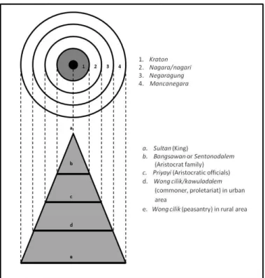
Yogyakarta city had a hierarchical-concentric pattern according to cosmological significance. The domain of the king spread outward following concentric circles.

Yogyakarta city exhibits a common spatial pattern where spatial arrangement was concentrated in the center, while rural areas surrounding the city center remained less arranged. Although the power of the king weakened as it spread outward, it was potentially infinite. Therefore, no real boundaries like physical boundaries to the state were recognized. The existence of delineation is not the physical territory boundaries but the structure of relationships among elements which marked up space. The strength of a ruler and his state was based on the number of subjects under his control rather than the size of the territory, where a king had absolute control primarily over the people but not territory (Palmier 1960, Santoso 2008). This is understandable since land was meaningless without people to cultivate it. The ruler of a neighboring kingdom was, unless he had subordinated himself, necessarily an enemy.

It formed four concentric rings where kraton was the center. The inner center is the area inside the baluwarti fortress, which consists of the kraton and royal compounds. Baluwarti fortress has great fortified walls and is installed with jagang (moat) and extending buttresses on each corner. The access to the inner fortress was through five gates, called plengkung. The main building of kraton protected by cepuri kedhaton (palace wall) is the house of the reigning king and his family also the place to keep royal pusaka. In addition the kraton, the area inside the wall is also used for the residents of noble families, royal bodyguard regiments, abidalem (royal servant) and other royal compounds called Tamansari (water castle).

The second ring which was called Nagara (royal capital) is an area outer baluwarti fortress.

It was the capital of the city where kepatihan, the office of the chief minister, was located.

In the second ring were predominately located the dwellings of important noble families

and high royal officers as well as the foreigner settlements. It was also surrounded by

Narawita dalem, the agricultural lands which directly supplied the kraton’s logistical needs

such as vegetables, fruits and grasses.

(24)

14

The third ring was called Nagaragung (great royal capital). The outer rings consisted of countryside areas with peasant population called Mancanegara (remote territory). The areas of mancanegara were scattered across central and southern Java, and had only poor communications with the capital. In relation to concept of macrocosm-microcosm, the spatial structure showed a sacred-profane concept. Kraton is sacred area, while nagara is profane. The concept could be superimposed in relationship between negaragung and mancanegara, where mancanegara is profane with respect to nagaragung.

Figure 2-3. The social structure of society analog to spatial hierarchy of Yogyakarta Source: Own construct, based on Soemardjan (2009), Behrend (1989), Zahnd (2008)

The plan of early Yogyakarta town corresponded to the social structure of society (see figure 2-3). The ruler in his kraton (palace) in the center formed the focus of a city. He was surrounded in the concentric circles by religious and worldly leaders respectively, and by servants, soldiers and artisans, and outside the town by foreign traders and farmers. This represented the structures of the cosmos with the gods in the center surrounded by the common people on the periphery. The concentric rings from the center to periphery represented the concentration of the power and prestige in the center and decreasing outwards. It took the form of a pyramid, with the sultan at the top.

Society was stratified based on proximity to the reigning ruler. Most importantly, this was a

question of bilateral kinship. There was a general distinction between the ruling class

(gusti) and the subject class (kawula), where priyayi was between these two classes

(Moertono 1985). The ruling class consisted of those persons who were associated with the

king. Those of the first group were bangsawan or sentono dalem (royal aristocrats) who

have direct bloodline with the king, and those of the second group were priyayi (non-royal

nobles). There were two criterions which determined the degree of nobility inherited from

traditional Mataram Kingdoms. The first was the hereditary relationship with the reigning

(25)

15

king, while the second was determined by their position in kraton bureaucracy. These criterions granted the relevant level in social stratification. The subject class consisted of wong cilik (commoner) included peasantry and lower-class in urban and rural areas.

Commoners living in the urban area were generally involved in trade, like wong sudagar (merchant), or became abdi dalem (servant). While others who inhabited rural areas usually worked as farmers.

iii. Caturgatra Tunggal as the Basic Component of the City

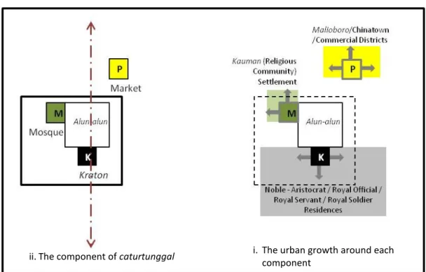
Yogyakarta palace city was placed as the capital of the kingdom and became the center of the sultanate. The city became the center of politics, religion and of economic and residential activities. Those important roles were structured in caturtunggal, (four in one) as the spatial concept of Yogyakarta city. Caturtunggal means four elements in unity (see Figure 2-4), which are:

- Kraton (palace) complex, as the royal district. It is the origin of the city which had the role as of the center of power held by a king.

- Alun-alun (central square) as the part of the royal district is the central gathering space and point of contact between the king and his subjects.

- Masjid Gedhe (great mosque), as the religious district. It is a center and symbol of the religion being followed.

- Pasar Gedhe (great market), as the commercial district. It is the center of trade and economic activities.

Figure 2-4. Caturgatra Tunggal as the main structure of the city and accelerator of urban growth Source: Author’s construct based on Ikaputra (1995)

ii. The component of caturtunggal i. The urban growth around each

component

(26)

16

Yogyakarta city exhibit a common spatial pattern where spatial arrangement was concentrated in the center, while rural areas surrounding the city center remained less arranged. Some scholars in understanding Yogyakarta city argue that the king initially built only the important symbolic components of the city and neglected the importance of settlement for common people (Ikaputra 1995). This statement is based on the microcosms-macrocosms concept which provides an assumption that a city is primarily built as an affirmation of the political power (and ritual purity) of kings (Heine-Geldern 1942, Behrends 1989, Kostof 1993). So the establishment of a city was initiated by building only important-symbolic components as its core and neglecting residential for commoners as it was considered more profane. There is no doubt that the dominating orthogonal layout represented by kraton, masjid and a large plaza, is an indication of central planning by a king. This does not mean that residential areas for the commoners were not arranged.

In the case of Yogyakarta, settlements for royal purposes were orthogonally built based on type of royal service, while settlements for commoners were organically grown following the basic pattern of city core. Residential zones were organized into royal service-based and lineage-based neighborhoods that served as administrative units. Residential areas inside the palace wall were inhabited by nobles and kings’ servants, while those outside were inhabited by royal soldiers, royal officials and others.

According to Rossi (1989) the function of urban elements is changeable with time, but they participate in the evolution of the city in a permanent way. They are constants and can be traced until today. The origin of Yogyakarta is rooted in the earliest phase of constructing kraton and its surroundings, which resemble the indigenous concept of the previous Mataram empire. Each component of caturtunggal concept organically accelerated development of the residential pattern in surrounding areas, while north alun-alun centrally located among the other three elements remains static in its growth (Figure 2-5).

The noble houses, royal offices and servant’s settlement developed surrounding kraton and south alun-alun. The Muslim religious leader settlements, called kampong Kauman, grew around the Great Mosque. Pasar also reinforced trading activities and invited more people, mainly Chinese merchants to reside, and who later developed Pecinan (Chinatown).

iv. Kraton

The architecture of kraton is an earthly representation of cosmic order. It is a symbolic representation of cosmos and by creating the palace as a cosmic model the king establishes his religious legitimacy. Kraton is considered to be the center of the universe and its arrangement is the sultan’s effort to create harmony in life among the king, his subjects, and the universe. Therefore the design was based on considerations to keep the balance and harmony between humans and the environment, applying basic Javanese ethics without causing opposition contrary to the surroundings.

Kraton in general is a royal palace which functions as both residence and the throne of the

king. It is the center of the kingdom, the symbol of ultimate power, the core from which the

city grows. The term of ‘kraton’ refers to two types of understanding; one is a socio-

Abbildung

Figure 2-3. The social structure of society analog to spatial hierarchy of Yogyakarta   Source: Own construct, based on Soemardjan (2009), Behrend (1989), Zahnd (2008)
Figure 2-4. Caturgatra Tunggal as the main structure of the city and accelerator of urban growth  Source: Author’s construct based on Ikaputra (1995)
Figure 3-1. Social space relationship
Table 4-1. Source of evidence for present and historical data  Source: Author’s construct based on Yin (2009:103-113)
+7

Referenzen

ÄHNLICHE DOKUMENTE

The International Summer School 2016 of the ARL (German Academy for Spatial Research and Planning) will be held in cooperation with the Department of Human Geography at Stockholm

1) The name “Essaouira” is based on the Arabic word “Es Saouira”, which means “the fortified place”. The settlement was first known by the Berber name Amogdul. The Por-

» Acknowledging public space as a form of social inf- rastructure provides the fundamental understan- ding of its importance and underlying structure for society and the

To determine whether or not Potsdamer Platz represents an authentic public place, I will compare the design of its architecture and open, landscaped spaces to other sites in the

The specificity of a particular composition, increase of expressiveness and diversity of space without loss of orientation quality, as well as the creation of additional

• Acknowledging public space as a form of social infrastructure provides the fundamental understanding of its importance and underlying structure for society and the city.

At the end of the 19 th century, imagination is considered as a resource not only by artists but also by many other professionals: doctors (in their theories or when they

Unlike conventional participation tools ICT, social media and mobile technologies provide an alternative, virtual platform, that enables citizens to connect with decision