Edited by:
Sabrina Speich, École Normale Supérieure, France Reviewed by:
Francisco Werner, National Marine Fisheries Service (NOAA), United States Guimei Liu, National Marine Environmental Forecasting Center, China Edgar G. Pavia, Ensenada Center for Scientific Research and Higher Education (CICESE), Mexico
*Correspondence:
Joaquín Tintoré jtintore@socib.es Specialty section:
This article was submitted to Ocean Observation, a section of the journal Frontiers in Marine Science Received:09 May 2019 Accepted:27 August 2019 Published:13 September 2019
Challenges for Sustained Observing and Forecasting Systems in the
Mediterranean Sea
Joaquín Tintoré1*, Nadia Pinardi2, Enrique Álvarez-Fanjul3, Eva Aguiar4, Diego Álvarez-Berastegui4, Marco Bajo5, Rosa Balbin6, Roberto Bozzano7, Bruno Buongiorno Nardelli7, Vanessa Cardin8, Benjamin Casas9,
Miguel Charcos-Llorens4, Jacopo Chiggiato5, Emanuela Clementi10, Giovanni Coppini10, Laurent Coppola11, Gianpiero Cossarini8, Alan Deidun12, Salud Deudero6,
Fabrizio D’Ortenzio11, Aldo Drago12, Massimiliano Drudi10, Ghada El Serafy13, Romain Escudier11, Patrick Farcy14, Ivan Federico10, Juan Gabriel Fernández4, Christian Ferrarin5, Cristina Fossi15, Constantin Frangoulis16, Francois Galgani17, Slim Gana18, Jesús García Lafuente19, Marcos García Sotillo3, Pierre Garreau14, Isaac Gertman20, Lluis Gómez-Pujol21, Alessandro Grandi10, Daniel Hayes22, Jaime Hernández-Lasheras4, Barak Herut20, Emma Heslop23, Karim Hilmi24, Melanie Juza4, George Kallos25, Gerasimos Korres16, Rita Lecci10, Paolo Lazzari26, Pablo Lorente3, Svitlana Liubartseva10, Ferial Louanchi27, Vlado Malacic28, Gianandrea Mannarini10, David March29, Salvatore Marullo30, Elena Mauri26, Lorinc Meszaros13, Baptiste Mourre4, Laurent Mortier31, Cristian Muñoz-Mas4, Antonio Novellino32, Dominique Obaton33, Alejandro Orfila9, Ananda Pascual9, Sara Pensieri7, Begoña Pérez Gómez3, Susana Pérez Rubio3, Leonidas Perivoliotis16, George Petihakis16, Loic Petit de la Villéon14, Jenny Pistoia10, Pierre-Marie Poulain8, Sylvie Pouliquen14, Laura Prieto34, Patrick Raimbault35, Patricia Reglero6, Emma Reyes4, Paz Rotllan4, Simón Ruiz9, Javier Ruiz36, Inmaculada Ruiz4, Luis Francisco Ruiz-Orejón37, Baris Salihoglu38, Stefano Salon8, Simone Sammartino19, Agustín Sánchez Arcilla39, Antonio Sánchez-Román9, Gianmaria Sannino40, Rosalia Santoleri5, Rafael Sardá37, Katrin Schroeder5, Simona Simoncelli41, Sarantis Sofianos25, Georgios Sylaios42, Toste Tanhua43, Anna Teruzzi8, Pierre Testor31, Devrim Tezcan44, Marc Torner4, Francesco Trotta2, Georg Umgiesser5, Karina von Schuckmann33, Giorgia Verri10, Ivica Vilibic45, Mustafa Yucel44, Marco Zavatarelli2and George Zodiatis46
1SOCIB and IMEDEA (CSIC-UIB), Palma, Spain,2Department of Physics and Astronomy, University of Bologna, Bologna, Italy,3Puertos del Estado, Madrid, Spain,4SOCIB, Palma, Spain,5Consiglio Nazionale delle Ricerche, Istituto di Scienze Marine, Venezia, Italy,6COB, IEO, Mallorca, Spain,7National Research Council of Italy, Rome, Italy,8Istituto Nazionale di Oceanografia e di Geofisica Sperimentale, Trieste, Italy,9IMEDEA (CSIC-UIB), Mallorca, Spain,10CMCC–Fondazione Centro Euro-Mediterraneo sui Cambiamenti Climatici, OPA Division, Lecce, Italy,11Sorbonne Université, CNRS, Laboratoire d’Océanographie de Villefranche, Villefranche-sur-Mer, France,12Department of Geosciences, University of Malta, Msida, Malta,13Stichting Deltares, Delft, Netherlands,14Ifremer, Brest, France,15Dipartimento di Scienze Fisiche, della Terra e dell’Ambiente, Università di Siena, Siena, Italy,16Institute of Oceanography, Hellenic Centre for Marine Research, Athens, Greece,17IFREMER, Bastia, France,18OR Consulting, Ariana Center, Ariana, Tunisia,19Departamento de Física Aplicada II, Universidad de Málaga, Málaga, Spain,20Israel Oceanographic & Limnological Research, National Institute of Oceanography, Haifa, Israel,21Department of Biología, Universitat de les Illes Balears, Palma, Spain,22Oceanography Center, University of Cyprus, Nicosia, Cyprus,23Intergovernmental Oceanographic Commission, UNESCO, Paris, France,24Institut National de Recherche Halieutique, Casablanca, Morocco,25National and Kapodistrian University of Athens, Athens, Greece,26OGS, Trieste, Italy,27ENSSMAL, Algers, Algeria,28National Institute of Biology, Marine Biology Station Piran, Piran, Slovenia,
29Centre for Ecology and Conservation, University of Exeter, Exeter, United Kingdom,30ENEA, Rome, Italy,31LOCEAN, Paris, France,32ETT, Genoa, Italy,33Mercator Ocean International, Toulouse, France,34ICMAN, CSIC, Cadiz, Spain,35Aix-Marseille Université, Mediterranean Institute of Oceanography, Marseille, France,36ICMAN, CSIC, Spanish National Research Council, Madrid, Spain,37Centre d’Estudis Avançats de Blanes (CEAB-CSIC), Blanes, Spain,38Institute of Marine Sciences, Erdemli, Turkey,39LIM-UPC, Barcelona, Spain,40ENEA, Rome, Italy,41Istituto Nazionale di Geofisica e Vulcanologia, Sezione di Bologna, Bologna, Italy,42Department of Environmental Engineering, Democritus University of Thrace, Xanthi, Greece,
43GEOMAR, Kiel, Germany,44Institute of Marine Sciences, METU, Ankara, Turkey,45Physical Oceanography Laboratory, Insitute of Oceanography and Fisheries, Split, Croatia,46CYCOFOS, Nicosia, Cyprus
The Mediterranean community represented in this paper is the result of more than 30 years of EU and nationally funded coordination, which has led to key contributions in science concepts and operational initiatives. Together with the establishment of operational services, the community has coordinated with universities, research centers, research infrastructures and private companies to implement advanced multi-platform and integrated observing and forecasting systems that facilitate the advancement of operational services, scientific achievements and mission-oriented innovation. Thus, the community can respond to societal challenges and stakeholders needs, developing a variety of fit-for-purpose services such as the Copernicus Marine Service. The combination of state-of-the-art observations and forecasting provides new opportunities for downstream services in response to the needs of the heavily populated Mediterranean coastal areas and to climate change. The challenge over the next decade is to sustain ocean observations within the research community, to monitor the variability at small scales, e.g., the mesoscale/submesoscale, to resolve the sub-basin/seasonal and inter-annual variability in the circulation, and thus establish the decadal variability, understand and correct the model-associated biases and to enhance model-data integration and ensemble forecasting for uncertainty estimation. Better knowledge and understanding of the level of Mediterranean variability will enable a subsequent evaluation of the impacts and mitigation of the effect of human activities and climate change on the biodiversity and the ecosystem, which will support environmental assessments and decisions. Further challenges include extending the science-based added-value products into societal relevant downstream services and engaging with communities to build initiatives that will contribute to the 2030 Agenda and more specifically to SDG14 and the UN’s Decade of Ocean Science for sustainable development, by this contributing to bridge the science-policy gap. The Mediterranean observing and forecasting capacity was built on the basis of community best practices in monitoring and modeling, and can serve as a basis for the development of an integrated global ocean observing system.
Keywords: observing and forecasting systems, sustained observations, ocean variability, FAIR data, climate, operational services, science with and for society, SDG’s
Abbreviations:ADCP, Acoustic Doppler Current meter Profiler; Argo, Global array of subsurface profiling floats; BiOS, Bimodal Oscillation System; CALYPSO, Coherent Lagrangian Pathways from the Surface Ocean to Interior; CMEMS, Copernicus Marine Environment Monitoring Service; CAPEMALTA, Meteo and marine operational forecasting system for the Maltese Islands; CTD, Conductivity Temperature Depth; CYCOFOS, Cyprus Coastal Ocean Forecasting System; EOV, Essential Ocean Variable; EU, European Union; CO2, Carbon dioxide; CSIC, Spanish National Research Council; DEKOSIM, Center for Marine Ecosystems and Climate Research; EMODnet, European Marine Observation and Data Network; EOOS, European Ocean Observing System; EuroGOOS, European Global Ocean Observing System; FAIR, Findable, Accessible, Interoperable, Re- Usable; FB, Ferrybox system; GCOS, WMO Global Climate Observing System;
GEO, Group on Earth Observations; GitHub, A web-based hosting service for software development projects that use the Git revision control system;
GIS, Geographic Information System; GOOS, Global Ocean Observing System;
GTS, Global Teleconnection System; ICCAT, International Commission for the Conservation of Atlantic Tunas; IEO, Spanish Institute of Oceanography;
IEOOS, IEO Observing system around Spanish mainland, the Canary and the Balearic Islands; Ins-TAC, the In Situ Thematic Assembly Center;
IOC, Intergovernmental Oceanographic Commission of UNESCO; IODE, IOC International Oceanographic Data and Information Exchange; IPCC, International Panel Climate Change; ISO, International Standards Organization;
IOLR, Israel Oceanographic & Limnological Research; ISRAMAR, Israel Marine Data Center; LDCs, Least Developed Countries (LDCs); MAOS, Mobile Autonomous Oceanographic Systems; MARIA, Atmospheric and wave forecasting system for the Sicilian Channel; Med-Argo, Argo Regional Center for the Mediterranean; Med-MFC, CMEMS Mediterranean Monitoring and Forecasting Center; MONGOOS, Mediterranean Oceanography Network for Global Ocean Observing System; MOOSE, Mediterranean Ocean Observing System for the Environment; NODC, National Oceanographic Data Centers; ODYSSEA, Operating a Network of Integrated Observatory Systems in the Mediterranean Sea;
PORTUS,Puertos del Estado (in Spanich)System; POSEIDON, HCMR monitoring and forecasting system; QA/QC, Quality Assurance/Quality Control; RADMED, Radiales Mediterráneo (in Spanish); REMPEC, Regional Marine Pollution Emergency Response Center for the Mediterranean Sea; RITMARE, Ricerca ITaliana per il MARE; ROOS, Regional Ocean Observing System; ROSARIO, Malta shelf thermo-hydrodynamic forecasting sysyem; R/V, Research Vessel; SAMOA, Sistema de Apoyo Meteorológico y Oceanográfico a las Autoridades portuarias in Spanish.; SANIFS, Southern Adriatic Sea and Northern Ionian Forecasting System;
SeaDataNet, Pan-European infrastructure for ocean and marine data management;
SE LB, South Eastern Levantine Basin; SDG(s), Sustainable Development Goal (s);
SDG14, Sustainable Development Goal 14: Life below the sea; SDG13, Sustainable Development Goal 13: Climate action; SeaDataCloud, Further developing the pan- European infrastructure for marine and ocean data management; SELIPS, South
INTRODUCTION
The Mediterranean Sea is an ideal laboratory for studying ocean processes of global relevance, such as water mass formation, overturning circulation, boundary currents, meso/submesoscale eddies and instabilities, carbon export and associated ecosystem responses (Pinardi et al., 2006; Malanotte-Rizzoli et al., 2014).
The Mediterranean is one of the most vulnerable regions in the world due to the impacts of climate change (e.g., alterations in the overturning circulation; extreme wave heights and warming, sea level rises, storm surges, acidification, oxygen depletion, invasive species, etc.), and its precarious socio-economic conditions and fragile political systems, particularly in more vulnerable southern shore countries.
From a societal perspective, stakeholders across the Mediterranean Sea (harbors and marinas, fisheries and aquaculture, oil companies, maritime transport, civil protection, tourist resorts, environmental agencies, research institutions, citizen associations, etc.) are already aware of the potential benefit of establishing an ocean observing and forecasting system. Establishing a sustained Mediterranean system is therefore timely and stakeholders have already recognized the importance of embracing the entire value-adding ocean chain, from observations to forecasts and customized products, thus providing the foundations for a sustainable Blue Economy compliant with the UN’s Sustainable Development Goals (SDG).
The Mediterranean research community has organized several programmes and projects to develop the end-to-end system, which will contribute mainly but not only to the UN SDG13 (Climate Action) and SDG14 (Life Below Water) goals and the Sendai Framework for Disaster Risk Reduction. A good example is the well-established Mediterranean modeling system, which is structured around the Copernicus Marine Environment Monitoring Service (CMEMS) and national and sub-regional downscaled forecasting systems, with numerous high-quality applications providing user-oriented services. In addition, advanced multi-platform and integrated observing systems are continually being developed and implemented by universities, research centers, European research infrastructures and private companies facilitating mission-oriented innovation that feeds into CMEMS (Le Traon et al., 2019) and the EMODnet programme (Martín Miguez et al., 2019).
Thus, the community can respond to science priorities, societal challenges and stakeholders needs, developing a variety of fit-for-purpose products. The combination of state-of-the-art observations and forecasting models provides new opportunities for downstream services in response to the needs of the heavily populated Mediterranean coastal areas. However, the observing and forecasting system has various deficiencies and shortcomings, such as:
Eastern Levantine Israeli Prediction System; SISCAL, Satellite-based Information System on Coastal Areas and Lakes; SISMER,Systèmes d’informations scientifiques pour la Mer (in French);SKIRON, Operational Atmospheric Forecasting System;
SOCIB, Balearic Islands Coastal Ocean Observing and Forecasting System; SST, Sea Surface Temperature; SeaDataNet, Pan-European infrastructure for ocean &
marine data management; SWOT, Surface Water and Ocean Topography; TAC, Thematic Assembly Center; WMO, World Meteorological Organization; WAM, Wave Model; WRF, Weather Research and Forecast atmospheric Model.
• The lack of sustainedin-situobservations for several Essential Ocean Variables (EOVs) and sometimes poor data policy, particularly in the Central-Eastern Mediterranean and on the Northern African coasts.
• The diversity of the forecasting models is limited and their skills have not been fully assessed yet;
• There is little connection between the development of the satellite observing system and situ components, which is in many instances hampering the opportunity to extend the range of observables from space. Satellite observations cover the entire Mediterranean but only provide surface information and at scales that are not of high enough resolution to capture the fine-scale processes that characterize the high temporal and spatial variability of this basin.
• Existing networks are only supported by national research funds and their long-term sustainability is at risk. Coordination and basin-scale integration is difficult, particularly across-disciplines (e.g., fishery data collection vs.
physics and biogeochemistry).
• Communication with the wide range of regional policy stakeholders is generally lacking and requires development.
The Mediterranean observing and forecasting systems are part of a larger ocean value chain that links observations to applications of societal benefit. This value chain can be subdivided into the “basic” or “core” systems/services, which are mainly related to observations and forecasting products/infrastructures, and
“downstream” services that generate customized products for policy makers, industry and the general public. The “basic”
infrastructure is essential for the downstream services, and it must run smoothly and have a fully open and free data policy.
The aim of this paper is to review the current status of the Mediterranean Sea environmental and climate challenges and document the present observing and forecasting system organization and the downstream services, resulting in an analysis of the gaps and deficiencies. Solutions are then proposed, with a special focus on the challenges to be faced over the next decade. In section Mediterranean Sea Environmental and Climate Challenges, the major Mediterranean Sea environmental and climate challenges are discussed, and the basic systems including the Mediterranean Oceanography Network for Global Ocean Observing System (MONGOOS) collaborative framework are presented in sections Basic Systems and Services and MONGOOS Collaborative Framework. Section Downstream Services in Response to Societal Challenges and Stakeholders provides examples of the downstream services in place.
Section Gaps and Prospects for the Next Decade gives a description of the gaps and future actions, and section Conclusions concludes.
MEDITERRANEAN SEA ENVIRONMENTAL AND CLIMATE CHALLENGES
In the last few decades, anthropogenic pressures (e.g., climate change, local pollution, tourism, fisheries, maritime transport, etc.) on the Mediterranean ecosystems have increased. As a consequence, significant and likely irreversible changes are
occurring in Mediterranean waters including the warming of deep waters, increased anthropogenic carbon dioxide inputs and uptake, acidification and biodiversity loss. Such factors are severely damaging the ecosystems in surface and intermediate/deep waters and marine habitats as a whole.
The recent Ocean State Report from the Copernicus Marine Environment Service (von Schuckmann et al., 2018) stated that the sea surface temperature between 1993 and 2016 in the Mediterranean has increased by 0.04 ± 0.004◦C per year, which is the second largest trend in the European regional seas after the Black Sea. Sea surface salinity also increased 0.01 PSU per year average over the whole basin in the same time period. The sea level has increased by 2.7± 0.9 mm per year, comparable to the increase in the North West Shelf and Black Sea but less rapidly than the Baltic Sea and the global ocean, probably due to the salinity trend and the hydrological cycle changes but also to the specific semi-enclosed nature of the basin (Pinardi et al., 2014).
The Mediterranean Sea has also been identified as an important anthropogenic carbon pool where the column inventory is much higher than in the Atlantic (Álvarez-Berastegui et al., 2016; Schneider et al., 2018). This is due to its intrinsic physico-chemical characteristics, in which warm and highly alkaline waters are prone to absorb high amounts of CO2from the atmosphere and transport it to deep waters via a number of convective areas. However, the variability of inorganic carbon remains unknown, given the lack of observations of the carbonate system at present. While at the global scale CMEMS models simulate a relatively stable ocean carbon uptake during the 1990s and a sharp increase since the beginning of the 2000s, the Mediterranean Sea appeared to act as a weak sink over the last decade (−3.5 gC/m2/year in 2016,von Schuckmann et al., 2018).
The time-mean circulation is now well known (Figure 1) from both reanalysis and observations (Rio et al., 2014; Pinardi et al., 2015; von Schuckmann et al., 2016). It is composed of multiscale structures, such as basin-scale gyres, intensified boundary currents, open ocean intensified jets and recurrent and reversing gyres (Font et al., 1988; Poulain et al., 2007; Pinardi et al., 2015). A well-documented intense climatic event occurred in the nineties, the so-called Eastern Mediterranean Transient (EMT,Klein et al., 1999), which radically changed the deep-water properties of the basin. This is the only event of its kind, captured during a basin-scale survey carried out in the 1990s. The change involved a reversal of the Northern Ionian Sea circulation, also called the Adriatic-Ionian Bimodal Oscillation System (BiOS, Gaˇci´c et al., 2011), which was found to be correlated to wind stress curl changes (Demirov and Pinardi, 2002; Nagy et al., 2019).
These changes are specific to the Mediterranean Sea and had a significant impact on the ecosystem functioning at the basin scale (Danovaro et al., 2001).
In the Western Basin, a second climatic anomaly known as the Western Mediterranean Transient (Schroeder et al., 2016) began between 2004 and 2006 during very cold winters. It was induced by intense heat flux losses and deep water formation in the Gulf of Lion (Schroeder et al., 2008), leading to an abrupt increase of temperature and salinity in deep waters and thus accelerating the trends observed over the past 40 years (Borghini et al.,
2014). It also resulted in an anomalous stratification of the deep- water column due to the superposition of newly formed warmer and saltier deep waters (Schroeder et al., 2016). The outflow of these waters through the Strait of Gibraltar is detectable in late winter-early spring (García-Lafuente et al., 2011; Sammartino et al., 2015) and it was clearly identified a decade later (Naranjo et al., 2017). Repeated glider missions along the Ibiza Channel endurance line have provided key semi-continuous observations, from which the variability of the meridional exchanges in the Western basin and its relation to surface and intermediate water mass changes can be monitored (Heslop et al., 2012; Juza et al., 2019).
From a biogeochemical point of view, the Mediterranean Sea has relatively high O2concentrations in deep waters, caused by intense ventilation mechanisms resulting from winter deep ocean convection processes (Schneider et al., 2018). In the intermediate layer occupied by the Levantine Intermediate Water (LIW), a minimum oxygen layer (OML) is present throughout the Mediterranean Sea. With global warming, these concentrations have become very sensitive to an overall decrease in O2, as predicted by climate and biogeochemical models, particularly in response to an increase in water column stratification (Oschlies et al., 2008). However, the energetics of the basin circulation have recently been studied and it was found that both buoyancy and wind inputs contribute to invigorating the total energy of the circulation, thus providing evidence of the basin’s intrinsic resilience to de-oxygenation processes (Cessi et al., 2014). In the past the Mediterranean is known to have been prone to large deoxygenation events, known as sapropels (Negri et al., 2009).
The N/P ratios in the Mediterranean deep waters are higher than in the global ocean (about 24:1 vs. 16:1) with a marked horizontal gradient from west to east (Bethoux et al., 2002).
This is explained by a preference for phosphate consumption over nitrate by phytoplankton, indicating a phosphate limitation, particularly in the eastern basin (Thingstad et al., 2005; Pujo-Pay et al., 2011). More recent studies have highlighted the significant contribution of anthropogenic inputs of (N,P) through the atmosphere and rivers to surface and intermediate waters in the Mediterranean (Cossarini et al., 2012), and a high variability of surface nutrients related to the variability of the mixed layer depth, particularly in the Western basin (Pasqueron de Fommervault et al., 2015). The Mediterranean is also known to be an oligotrophic basin with some intermittent bloom regions (D’Ortenzio and Ribera d’Alcalà, 2009; Mayot et al., 2017) but the general trend is not clear. Some future scenarios predict an increase of nutrients gradients whereas others suggest a homogenization of bio-regions toward oligotrophy or eutrophication (Lazzari et al., 2014; Colella et al., 2016).
Basin wide, the Mediterranean Sea is a region of significant fronts, mesoscale and submesoscale variability (Pascual et al., 2013; Bosse et al., 2017; Testor et al., 2018), which regulate the exchanges between the open sea, the shelves and the coastal areas (Pinardi et al., 2006; Jordi et al., 2008) although at smaller scales than in other parts of the global ocean, given the Sea’s small Rossby radius (Escudier et al., 2016b; Barcelo-Llull et al., 2019). Such mesoscale-submesoscale variability (McWilliams, 2016) drives the vertical exchanges between the upper layers and
FIGURE 1 |The time mean circulation from CMEMS reanalysis (period 1985–2017, product MEDSEA_REANALYSIS_PHYS_006_004). The velocity field is visualized by curved arrows overlaying the amplitude of the currents (m/s) in color. The detailed description of this circulation picture is offered inPinardi et al. (2015)and an update is given invon Schuckmann et al. (2016).
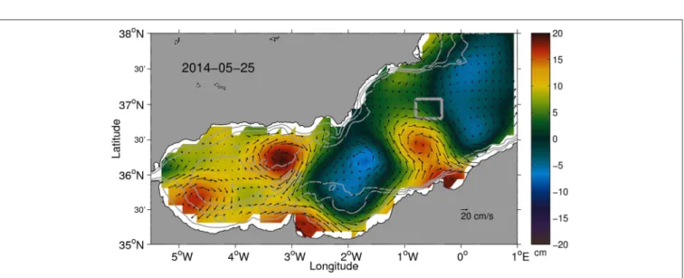
FIGURE 2 |Absolute dynamic topography and associated geostrophic currents for 25 May 2014 derived from gridded altimetry fields (CMEMS). The gray box corresponds to the domain sampled during the AlborEx experiment in the eastern Alborán Sea aimed at understanding meso- and submesoscale processes in an intense front [fromPascual et al. (2017)].
the deep ocean (Figure 2, Tintoré et al., 1991; Pascual et al., 2004; Ruiz et al., 2009) and in particular the supply of nutrients to the euphotic zone (Mahadevan, 2016; D’Asaro et al., 2018).
Given the ideal conditions of the Alborán Sea in the Western Mediterranean (Ruiz et al., 2009, 2018; Pascual et al., 2017) the international programme CALYPSO1was established in 2018 to provide an understanding and predictive capability of the three- dimensional coherent pathways by which water carrying tracers and drifting objects is transported from the surface ocean to depths below the mixed layer.
1https://calypsodri.whoi.edu
The heat and drought waves are also major challenges in terms of the water availability and preservation of marine ecosystems in the Mediterranean (Vautard et al., 2007). The risk of extreme heat waves in Europe, like the unprecedented event in the summer of 2003, is likely to increase in the future, and requires further understanding of their potential predictability and possible mitigation. Extensive mass mortality in benthic communities was registered after the 2003 heat event (Olita et al., 2007; Garrabou et al., 2009) and heat waves are now understood to boost harmful algal blooms (HAB) (Joehnk et al., 2008). There is also a general concern that jellyfish are becoming more prevalent in many regions around the Mediterranean Sea
(Shiganova et al., 2001; Kogovsek et al., 2010; Prieto et al., 2015).
Jellyfish have a significant impact on coastal economic activity and on the important tourism industry of the Mediterranean region (accounting for 15% of global tourism) (Ciscar et al., 2001), but no systematic, scientific based monitoring system at basin scale has been implemented (Prieto et al., 2015).
The sustainability of marine living resources is also a major challenge in the Mediterranean. Most of the fish stocks (78%) monitored by the General Fisheries Commission for the Mediterranean are overexploited (FAO 2018). Sustained monitoring could play a key role in knowledge-based fisheries management and ecosystem conservation. The recovery of the Eastern Atlantic bluefin tuna population during the last decade, after a long period of continuous and alarming decrease, is a successful example of how science and operational oceanography can trigger advances in the sustainability of fisheries and species conservation. At SOCIB, the combination of hydrodynamic models, remote sensing and in situ data has enabled the development of techniques for predicting both the spawning and larval habitat distribution, and the survival rate of the egg and larvae in the Balearic Sea (Álvarez-Berastegui et al., 2016;
Reglero et al., 2018). These novel predictive capabilities have been applied to the standardization of larval abundance indices used to evaluate the trends of adult tuna populations during the last two decades (Ingram et al., 2017; Álvarez-Berastegui et al., 2018a), and to integrate environmental variability into the short-term forecasting of the survival of larvae and the derived immature individuals. The International Commission for the Conservation of Atlantic Tunas (ICCAT) applies these methods to establish the annual fishing quotas for bluefin tuna and Mediterranean albacore tuna.
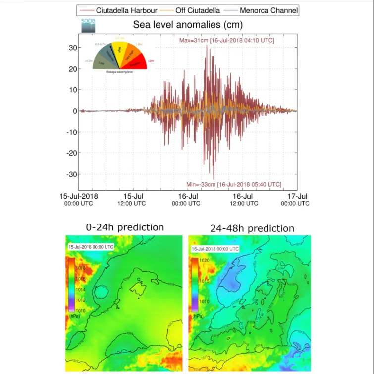
The Mediterranean Sea is also affected by tsunami-frequency sea level changes, which are not triggered by seismic activity but driven by air-pressure disturbances that are often simultaneous to fast-moving perturbations, such as thunderstorms, squalls, and other storm fronts. These episodes, called meteo-tsunamis (e.g., Vilibic et al., 2016), have been reported in Croatia, the Balearic Islands, Sicily, Malta and Greece. Specifically, Croatian islands and Menorca are where the highest magnitudes of meteotsunamis have been observed worldwide (6- and 4-m oscillations, respectively). Meteotsunamis generate flooding and are associated with very strong currents (up to 4 m/s), cause serious economic damage to ships and harbor installations and can travel long distances and influence a very long area of coastline (Masina et al., 2017; Picco et al., 2019).
Floating plastic pollution tend to concentrate on convergences acting as retention areas and in eddies and fronts at lower scales (Maximenko et al., 2012). In a recent study based on numerical simulations of plastic transport, Liubartseva et al. (2019) identify the potentially most polluted areas in this Sea from a series of anthropogenic sources, which confirm that the highest concentration of plastic is found near continental shores (Collignon et al., 2014; Ruiz-Orejón et al., 2016, 2018). Information is still limited but Eriksen et al.
(2014) estimated floating plastic debris in the Mediterranean as 23,150 tons, with 3,056 corresponding to micro- and nano- plastics, which mirrors the 1,500 tons estimated from samples obtained by Ruiz-Orejón et al. (2016). Biodiversity is highly
affected by marine litter, either through entanglement, ingestion or colonization (Deudero and Alomar, 2015; Fossi et al., 2018).
There is even a certain overlap between the feeding areas of diverse marine species and the convergence zones of floating microplastics (Fossi et al., 2017). Thus, observing and forecasting systems are essential in providing tools to understand the effects of plastics on species and ecosystems and to achieve the Good Environmental Status (GES) as set out in the European Marine Strategy Framework Directive (MSFD) (Galgani, 2019). The hazard mapping recently conducted by Compa et al. (2019a), which correlates litter with species distribution maps in the Mediterranean basin, is an interesting approach. Other potential observing systems for marine litter are the cleaning coastal vessels that provide densities, distribution and temporal patterns of floating marine macrolitter along coastal systems such as in the Balearic Islands (Compa et al., 2019b).
All these issues require a scientific basis for the understanding, monitoring and modeling of the Mediterranean Sea marine environment, and a collaborative international framework to design and implement the basic services in support of the downstream sector. The existing monitoring and forecasting system that have been developed over the past 20 years for operational oceanography need to be expanded to biochemical EOVs, and toward applications that will offer solutions for climate mitigation and adaptation, biodiversity conservation, decreased ocean pollution and more accurate met-ocean forecasts for disaster risk reduction.
BASIC SYSTEMS AND SERVICES
As described in the introduction, basic systems produce
“generic” products ready to be ingested by downstream services. The basic system infrastructure is composed of observing systems, forecasting and data assembly systems. In the following we describe each component in the Mediterranean Sea basic infrastructure.
Multi-Platform Observing Systems
Most of the present European regional observing systems described in this section have their origin in the coordinated efforts that started in the early nineties in the Mediterranean Sea, due to EU strategic planning and associated funded projects.
This has led to a well-structured and reasonably coordinated community that feeds real-time and delayed mode quality- controlled data into the different European portals, in particular through the CMEMS Mediterranean Monitoring and Forecasting Center (Med-MFC), thein situThematic Assembly Center (Ins- TAC,Petit de la Villeon et al., 2018) and EMODnet. However, the funding for the observing components is in most cases of only national origin and the sustainability of these key initiatives is a critical issue and an important concern.
MOOSE
In 2010, a Mediterranean Ocean Observing System for the Environment (MOOSE2) was implemented in France as an integrated observing network of the NW Mediterranean Sea.
2http://www.moose-network.fr
MOOSE objectives include the detection and identification of environmental anomalies via both long-term monitoring and near real-time measurements capabilities.
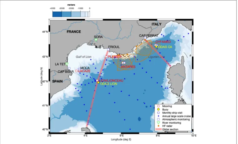
The MOOSE strategy is based on multisite and multi-platform continuous observations from the coast to the deep sea. It combines Eulerian observatories and autonomous Lagrangian platforms to collect the EOVs and is open to new approaches based on omics and modern imagery techniques, which can better address the emerging issues in marine ecology. It is designed to detect and monitor seasonal or inter-annual variability, and the impact of extreme events that control physical and biogeochemical fluxes and marine biodiversity. MOOSE also provides a large flow of real-time data to facilitate the validation of operational oceanographic models. The MOOSE strategy is based on an in-situobserving system, capable of capturing all scales of variability, thus avoiding any aliasing effects caused by sub-sampling. Thus, MOOSE aims to address scales of variability ranging from the very small (1 km horizontally, over a few days) to the basin scale (500 km, months/years), passing by the mesoscale (15 km, weeks/months). The MOOSE components are (Figure 3):
- Two river observatories (Rhône, La Têt)
- Three observatories for atmospheric deposition (Cap Béar, Frioul, Cap Ferrat)
- Two moorings in canyons (Lacaze-Duthiers, Planier), which are complimented by three open sea moorings from EMSO network (Lion, Dyfamed, and Albatross)
- Two HF radars (Toulon, Nice)
- Monthly and annual ship visits (Mola, Antares, Dyfamed, and MOOSE_GE)
- Two glider endurance lines along the north-south sections (Marseille-Minorca, Nice-Calvi)
Marine observations are accomplished by combining observations from fixed (deep moorings and buoys) and Lagrangian platforms (Argo floats and gliders) which are completed with ship surveys both in the coastal and open sea regions. In the MOOSE network, two glider endurance lines are currently in operation: Villefranche-Dyfamed-Calvi and Marseille-Lion-Menorca.
Deepwater convection processes and their interaction with dense shelf water cascading events modify deepwater mass properties and deep sediment resuspension in the Gulf of Lion (Durrieu de Madron et al., 2013). Over the past decade, the MOOSE network has documented a slow increase in deepwater temperature, punctuated by very rapid warming, leading to even warmer and saltier deep waters. The absence of intense convection reinforces the oxygen minimum signature in the intermediate waters, especially in the Ligurian Sea where the winter mixing and ventilation are less intense than in the Gulf of Lion (Coppola et al., 2018).
Regular and long-term monitoring in the MOOSE network has provided significant results that can be used to interpret the temporal variability of nutrients and the zooplankton community, which are sensitive to deep vertical mixing events (Donoso et al., 2017). Coastal observations showed that the long-term evolution of nutrient inputs here is driven by Rhône
River water discharges, which respond differently depending on whether a climatic or an anthropogenic forcing occurs (Cozzi et al., 2018).
SOCIB
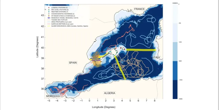
The Balearic Islands Coastal Ocean Observing and Forecasting System (SOCIB3) is a Marine Research Infrastructure, a multi- platform and integrated ocean observing and forecasting system that provides streams of data, added value products, and forecasting services from the coast to the open ocean (Tintoré et al., 2013). It was initiated in 2008 and since 2014 it is included in the Spanish Large-Scale Infrastructure Map. SOCIB aims to characterize ocean state and variability at different scales, from local to submeso-mesoscales and from nearshore and regional to large basin scales, on temporal ranges that span from events to climate.
Figure 4 shows the SOCIB network of observing infrastructures for long-term monitoring and for dedicated deployment during open access intensive multi-platform process-oriented studies. The network includes satellite-tracked surface and profiling drifters (through an annual deployment of 3 Argo floats4 and 8 SVP drifters), 16 autonomous fixed coastal stations deployed around the Balearic Islands, 2 met- ocean moorings located in the Ibiza channel and the bay of Palma, a 24 m coastal research vessel, 2 high-frequency radar stations overlooking the Ibiza Channel, a fleet of 7 autonomous underwater gliders and 2 beach monitoring stations. More specifically, SOCIB runs a glider endurance line in the Ibiza channel (a well-established biodiversity hot spot) to monitor the north-south exchanges and their relation to the variability of the circulation, of the different water masses and the associated ecosystem variability. Animal-borne instruments are a new addition to SOCIB and since 2015, tracked sea turtles complement the observing system with unique and cost-effective data (Patel et al., 2018) providing information on essential biodiversity variables and contributing to knowledge based marine conservation (Boehme et al., 2009). Complementary to this quasi-real time network, high-resolution beach bathymetries and sediment samples surveys, multidisciplinary seasonal oceanographic surveys in the Ibiza and Mallorca Channels and glider sections to Algeria and Sardinia are performed periodically, providing long-term observations that allow quantification of the variability, changes and trends in beach morphology, water mass transformation, mass and heat transport and content, eddies structure and variability, etc.
All SOCIB data are made available in near real time for scientists and society under the terms of an open access policy, in line with European initiatives such as Jericonext (Farcy et al., 2018). The data, scientific production, outreach and engagement activities, as well as tools and products developed are a clear performance indicator of SOCIB achievements and innovations in the new era of ocean observation. The alignment of these elements is possible due to a dedicated data lifecycle management that is fully committed with the Findable,
3www.socib.es
4Contribution to EuroArgo ERIC.
FIGURE 3 |The MOOSE observatory components including the EMSO open sea moorings.
Accessible, Interoperable and Reusable (FAIR) data principles (Wilkinson et al., 2016) and that also contributes to the IOC Ocean Best Practices System5(Pearlman et al., 2019).
From the SOCIB perspective, the real challenge for the next decade is the full integration of these technologies and multi-platform observing and forecasting systems. As a research infrastructure, SOCIB in partnership with CSIC and IEO scientists, combines operational, scientific and training activities.
SOCIB and similar infrastructures worldwide, due to their scientific excellence, critical mass, multidisciplinary, integrated and targeted approach, open data policy and sustained funding, are establishing new research ecosystems that facilitate mission- oriented innovation. Further details are provided section SOCIB Innovation, Products and Services.
The SOCIB observing system has contributed to, the understanding of the relationship between the north-south internannual exchanges and the water masses vertical structure (Heslop et al., 2012; Barcelo-Llull et al., 2019; Juza et al., 2019), the understanding of the dynamics of meso and submesoscale eddies and their impact on the circulation (Escudier et al., 2016a) and biogeochemical fluxes (Cotroneo et al., 2016; Pascual et al., 2017; Aulicino et al., 2018) and to the sustainability of Bluefin tuna in the Mediterranean (Álvarez-Berastegui et al., 2018b).
On the coastal and nearshore area, SOCIB has contributed to unravel the beach response to storminess and sediment budget
5www.oceanbestpractices.org
dynamics in Mediterranean beaches (Morales-Márquez et al., 2018; Gómez-Pujol et al., 2019).
POSEIDON
POSEIDON6was established in 1997 as a research infrastructure of the Eastern Mediterranean basin for the monitoring and forecasting of the marine environment. It supports the efforts of the international and local community and addresses the requirements of science, technology and society. The general aims are (a) to establish a sustainable marine observing network in the Eastern Mediterranean, (b) to provide quality and validated forecasts of the marine environment, (c) to provide scientific knowledge and support for the study of ocean mechanisms and their variability and to address the sensitivity of marine ecosystem and biodiversity combining natural forcing factors and anthropogenic pressures, and (d) to provide a technology test bed and services to marine policy-makers and society.
The system is being developed in accordance with the policy frameworks suggested by GOOS, EuroGOOS, MonGOOS, and GEO, while maintaining a balance between the operational and research characteristics of the infrastructure through the integration of methodologies and tools developed in relevant EU initiatives and projects. The data provided by POSEIDON in the Aegean and Ionian Seas sample a wide area. The present (2018) status of the POSEIDON observatory includes multiple platforms
6www.poseidon.hcmr.gr
FIGURE 4 |The components of SOCIB Multiplatform Observing Infrastructures as of 2019, extending from the coast and the nearshore Balearic beaches, to the coastal and open sea, and including contributions from SOCIB to EuroArgo ERIC and Jericonext. The glider endurance line toward Sardinia is jointly operated between CNR-ISMAR and SOCIB.
FIGURE 5 |Left: Platforms of Poseidon observatory. Right: Map showing the location of the POSEIDON system fixed platforms (AB, Athos Buoy; MB, Mykonos Buoy;
PB, Pylos Buoy; SB, Saronikos Buoy; E1-M3A Buoy) and Ferrybox route (yellow line) [fromPetihakis et al. (2018)].
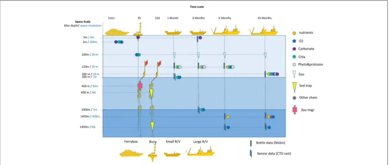
(Figure 5) operating at various spatiotemporal scales (Figure 6).
The components are:
- Three wavescan buoys are deployed in the S. Aegean (E1- M3A), N. Aegean (ATHOS) and Ionian waters (PYLOS) provide meteorological, physical and biochemical (O2, Chl-a) data (Petihakis et al., 2018).
- A Ferrybox system (FB) operating on the route connecting the ports of Piraeus (Athens) and Heraklion. This fully automated, flow-through system includes sensors of temperature, salinity, fluorescence, turbidity and pH. FB has been proven to be a
helpful tool in the study of water circulation (e.g., modified Black Sea Water flowing in the Aegean Sea), in particular when assimilated into prognostic numerical circulation models to improve their accuracy (Korres et al., 2014).
- Sampling of seawater and plankton, which is regularly conducted next to the fixed biochemical platforms and on board the FB. R/V visits are made monthly next to the E1-M3A site and the HCB.
- The Greek Argo infrastructure (www.greekargo.gr), which had 15 deployed floats in 2015 and 2016 (five of which were BGC- Argo) and aims for a total of 25 Argo floats, further contributes
to the international Argo community efforts to monitor the Eastern Mediterranean region.
- Interaction with several land-based facilities located nearby the observatory, which is necessary for sensor maintenance and the analysis of discrete samples. The calibration lab, micro- and mesocosms, meteorological stations, and
atmospheric deposition station are also key land-based components. In particular, the calibration lab, considering the local environmental conditions, is a powerful tool for the calibration of sensors deployed in the wider Mediterranean Sea (Bozzano et al., 2013; Pensieri et al., 2016).
FIGURE 6 |Time and space resolution of data acquisition by the different platforms of the POSEIDON observatory (Argos, Gliders excluded). Space resolution is vertical except for Ferrybox. Carbonate: pH or CT&AT, Other chem: other chemical parameters, Sed trap: sediment trap, Phyto & protozoo: phytoplankton and protozoans; Zoo: metazoans, Zoo migr: ADCP backscatter data for zooplankton-micronekton migration [fromPetihakis et al. (2018)].
FIGURE 7 |DEKOSIM Erdemli Time Series stations shown in red, the mooring site and seasonal monitoring indicated with orange.
The critical issue for the POSEIDON observatory is its sustainability. The multiparameter, multiplatform observatory approach allows for the participation in various research projects and thus the provision of funds through multiple sources.
In addition, the long experience acquired, and the particular conditions of the Eastern Mediterranean, makes the observatory an excellent test bed for new technology.
The POSEIDON system will offer additional products to a wider range of society users, through its expanded NRT data delivery, proxy estimations, hazard mapping, warning systems and higher resolution, in addition to addressing specific scientific questions. For example, deep water ADCP data from the Cretan Sea provided insights into important processes in terms of ecosystem functioning, such as zooplankton migration (Potiris et al., 2018). The observation of the various patterns of vertical migration and of mesopelagic inhabitants, makes possible the investigation of the role of these components in organic carbon sequestration.
DEKOSIM
The Center for Marine Ecosystems and Climate Research (DEKOSIM) is the leading oceanographic research center in Turkey. The center builds upon four decades of experience from the Middle East Technical University’s Institute of Marine Sciences. DEKOSIM provides knowledge transfer tools to assist authorities and other stakeholders to manage routine tasks and evaluate trends.
DEKOSIM activities since 2012 can be grouped into the three sectors of observing systems, model products and policy outputs.
Observing activities comprise fixed and mobile observatory development and expedition-based time series high-frequency observations. To initiate a sustainable, more comprehensive and long-term monitoring programme in the north-eastern Mediterranean, DEKOSIM started the Erdemli Time Series (ETS) programme in 2013, which built on the fragmented, semi-regular time series measurements collected since 1997. In ETS, a total of 9 stations between 20 and 500 m depths are monitored monthly for T, S, and DO (Figure 7). Further, monthly measurements for biological and chemical essential ocean variables (T, S, DO, Chl, Tur, Par, Secchi disk) are conducted at 4 selected stations at 20, 100, 200, and 500 m depths. In addition, monthly trawl surveys have been carried out since 2007 to investigate and monitor demersal fish stocks. A mooring system that has 7 underwater inductive sensors (T, S, DO) at different levels of the water column and meteorological sensors was deployed on the ETS at 100 m water depth. The data can be acquired daily from the mooring. DEKOSIM also supported Argo deployments in the region and 850 profile data have been acquired from 4 Argo floats in Black Sea and 2 in Mediterranean since 2013 within the DEKOSIM. The DEKOSIM information system provides data storage and quality control facilities, according to Seadatanet procedures. The two major scientific achievements, deriving from the DEKOSIM monitoring, are related to the characterization of a possible formation pathway for the LIW in the northern Cilician Basin and the strong land-sea coupling
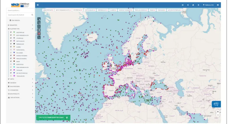
FIGURE 8 |Snapshot of the sampling platforms sending real time data to EMODnet Physics Portal (http://www.emodnet-physics.eu/Map/) as of 1 week in April 2019.
observed in North-eastern Mediterranean and the resultant relatively high productivity.
SELIPS-ISRAMAR
The South Eastern Levantine Israeli Prediction System (SELIPS) and the Israel Marine Data Center (ISRAMAR, https://isramar.
ocean.org.il) were established 20 years ago at the Israel Oceanographic & Limnological Research (IOLR) Center as a research and monitoring infrastructure. They provide scientific data and knowledge and effective management and protection programmes for the marine environment. Both systems were integrated in several national and international/EU initiatives dedicated to operational oceanography and data archiving.
The SELIPS-ISRAMAR contain various forecasting and observational platforms operating at different scales. Since 2002 bi-annual monitoring cruises have been conducted in the SE Levantine basin along transects from 20 to 1,700 m water depths, and 70 km offshore by the R/V Shikmona until 2016 and further by the R/V Bat Galim. Profiles of pressure, temperature, salinity, dissolved oxygen and fluorescence, along with water samples for alkalinity, dissolved oxygen, nutrients, chlorophyll-a (Chl- a), picophytoplankton and bacterial abundances, primary and bacterial production and bacterial diversity are collected at eight permanent stations.
IOLR established a modern near real-time meteo-marine monitoring station in 1992, 2.3 km offshore at the Hadera coal terminal (central Israel), which is identified as GLOSS station #80 (https://isramar.ocean.org.il/isramar2009/Hadera/).
The parameters monitored are sea level, waves, seawater temperature, salinity, dissolved oxygen, turbidity, fluorescence, and atmospheric pressure. A similar monitoring station was established 2.3 km offshore of Ashqelon (south Israel) in 2012.
IOLR has operated the Deep Levantine Marine Station (DeepLev) since November 2016, which is the first deep-moored research and monitoring station in the SE Levantine Basin (LB), located 50 km offshore of Haifa (Israel) at a water depth of 1,500 m. It carries an array of instruments, including various current meters (ADCPs), CTDs, sediment traps, fluorometers and turbidity sensors, aiming to produce a long-term, high- resolution characteristic of the physical, chemical, and biological dynamics of the water column. In addition, IOLR operates ocean gliders for monitoring activities, which conduct bi-annual transects along N-S and E-W at the SE LB.
Finally, since 2001 ISRAMAR has been a repository for oceanographic data (physical, chemical, biological) and acquires, archives and distributes data and information about the marine environment. It also contain a marine barcoding database consisting of DNA-barcode tagging, identification and taxonomy with the purpose of promoting taxonomic knowledge for marine biodiversity (https://isramar.ocean.org.il/IsraelBarcoding). Since 2007, a synoptic database of ocean color parameters offshore of Israel using Earth Observation has been generated by SISCAL (Satellite-based Information System on Coastal Areas and Lakes, operated by IOLR). These include maps of the Sea Surface Temperature (SST), Chlorophyll-a concentration, Total Suspended Matter and Secchi depth, obtained from operational ocean observing satellites.
The SELIPS-ISRAMAR has acquired 30 years’ worth of hydrographic observations, showing that the south-eastern Mediterranean Sea is getting saltier and warmer at rates in agreement or higher than the IPCC 2014 high end prediction (Ozer et al., 2017). In addition, Lagrangian analysis of circulation patterns has provided a better understanding of shelf-deep sea interactions and filament formation (Efrati et al., 2013).
PORTUS (Puertos del Estado System)
The observational component of the Portus system in the Mediterranean Sea consists of 7 deep water buoys (able to measure currents, SST, salinity, wind, atmospheric pressure, air temperature and waves), 6 coastal buoys (waves and SST), 2 HF radar systems (Catalan coast and straits of Gibraltar) and 16 tide gauges. This comprehensive observing system is fully integrated into the modeling component of the Portus (see the section below) and serves data for multiple socio-economic sectors with the main customer being the Spanish Port system, via the SAMOA service (see section Downstream Services in Response to Societal Challenges and Stakeholders). Real-time data access is provided via Portus web site7.
MAOS (Mobile Autonomous Oceanographic Systems) The MAOS8 is an Italian infrastructure using mobile autonomous instruments, such as gliders, floats and drifters, to measure marine properties with its main focus on the Mediterranean Sea. It contributes substantially to the Argo fleet in the Mediterranean with the deployment of about 20 floats annually since 2012. In addition to standard Argo floats, MAOS has operated several floats equipped with biogeochemical sensors and the first floats profiling as deep as 4,000 m in the Mediterranean. MAOS is also coordinating the deployment of all the Argo floats in the Mediterranean and is responsible for the delayed mode quality control of their data, in the framework of MedArgo (Poulain et al., 2007), the Argo Regional Center for the Mediterranean. Among various applications, Argo float data have been used to study convection and dense water formation in the Adriatic Sea (see for instanceBensi et al., 2013).
MAOS also regularly operates several types of surface drifters to monitor the surface currents and temperature, and maintains a historical drifter database (Menna et al., 2018). It uses four gliders to measure water mass properties in the Mediterranean, with the main focus on the Italian seas and the Levantine Basin. MAOS also runs a glider endurance line across the southern Adriatic Sea to monitor dense water formation processes.
RITMARE
The Italian RITMARE Flagship Programme, which began in 2012, aimed to implement the RITMARE Ocean Observing System for the Italian seas by building on existing infrastructures, to help implement national and European environmental regulations and to contribute to the future European Ocean Observing System. The network now integrates different platforms, i.e., coastal buoys, oceanographic towers, coastal, open ocean and cabled moorings, HF and X-band radars, gliders,
7http://portus.puertos.es
8http://maos.inogs.it
satellite products and modeling components. The ongoing efforts are aimed at increasing the number of active platforms, to align the sensors, improve the near real time QA/QC, and to develop new remote sensing algorithms and products.
The system presently consists of 17 fixed point observatories, 5 gliders, a variable number of operating drifters and floats, 3 HF radars, and several operational models. In addition, repeated transects on board R/Vs are conducted in all Italian Seas. Since 2015 a 6-monthly glider transect has been conducted between Sardinia and the Balearic Islands, in cooperation with SOCIB (see Figure 4).
The different components of the sustained RITMARE Observing System allow for the description of the carbonate system in coastal and offshore areas (Cantoni et al., 2012, 2016), and the climatology and long term trends of wind waves (Pomaro et al., 2017), to gain insights into dense water formation and dense shelf water cascading processes (Langone et al., 2016;
Schroeder et al., 2016), and to detect how climate change induces rapid responses in a marginal sea such as the Mediterranean (Schroeder et al., 2017).
IEOOS
The Spanish institute of Oceanography (IEO) maintains a historical ocean observing system around the Iberian Peninsula, and the Canary and the Balearic Islands, known as IEOOS (Tel et al., 2016). This system provides quality-controlled data from a wide network of tide gauges, hydrographic monitoring sections, permanent moorings, and underway monitoring and is a key contribution the ARGO international programme. Data and metadata following international standards are incorporated into the IEO data archive, linked to the Sea-DataNet network, and thus made accessible.
The RADMED monitoring programme (Lopez-Jurado et al., 2015) is a key element of IEOOS, and has systematically collected hydrographic sections from Barcelona to the Alborán Sea and around the Balearic Islands for over 20 years. This sustained effort has enabled the characterization of the seasonal and interannual variability, the effects of winter convective processes, the presence of water masses, mesoscale structures, transport and exchange between basins, cycles, trends and possible climate changes to be established, in addition to environmental and ecological studies of species (Balbin et al., 2014; García-Martínez et al., 2018).
RADMED data have been also used to update temperature and salinity mean values and trends in the Western Mediterranean (Vargas-Yañez et al., 2017). Additionally, the data has been used to characterize spatial and temporal long-term patterns of phyto and zooplankton in the Western Mediterranean (García- Martínez et al., 2019).
Forecasting Systems
The present European leadership in operational oceanography and ocean forecasting has its origin in the coordinated efforts in the Mediterranean that started in the early 1990s, due to EuroGOOS (Pinardi and Flemming, 1998) and the associated EU funded projects (Pinardi and Coppini, 2010), which are the origin of the present CMEMS Med-MFC discussed below.
CMEMS
The CMEMS systems in the Mediterranean are strongly connected to MONGOOS. The Mediterranean Monitoring and Forecasting Center (Med-MFC) is one of the regional production centers of CMEMS. Med-MFC operatively manages a suite of numerical model systems that provide analyses and forecasts of physical and biogeochemical variables for the Mediterranean Sea, with a horizontal resolution of 1/24◦ (about 3.5 km). The physical component of Med-MFC is provided by a coupled hydrodynamic-wave modeling system (Clementi et al., 2017), assimilating temperature and salinity vertical profiles, and satellite Sea Level Anomaly (Dobricic and Pinardi, 2008). It operationally provides daily updates of 10-day forecasts and weekly updates of analyses. Products include: 3D Temperature, Salinity, Currents; 2D Sea Surface Height, Mixed Layer Depth, Bottom Temperature, Stokes Drift, and Wavenumber.
The biogeochemical component of Med-MFC is forced by outputs provided by the physical component and assimilates the surface chlorophyll concentration measured from satellites.
Products include 3D daily fields of Chlorophyll, Nitrate (NO3), Phosphate (PO4), Net Primary Production, Phytoplankton Biomass, Dissolved Oxygen, CO2partial pressure, and Seawater Acidity (pH).
The wave component of Med MFC is based on a high resolution (1/24◦) operational wave forecasting system that provides on a daily basis 1-day hourly hindcasts and 5-days hourly forecasts of the wave environment in the Mediterranean Sea. The 17 available wave products include significant wave height, wind and primary/secondary swell significant wave height, periods, direction, and Stokes Drift velocity.
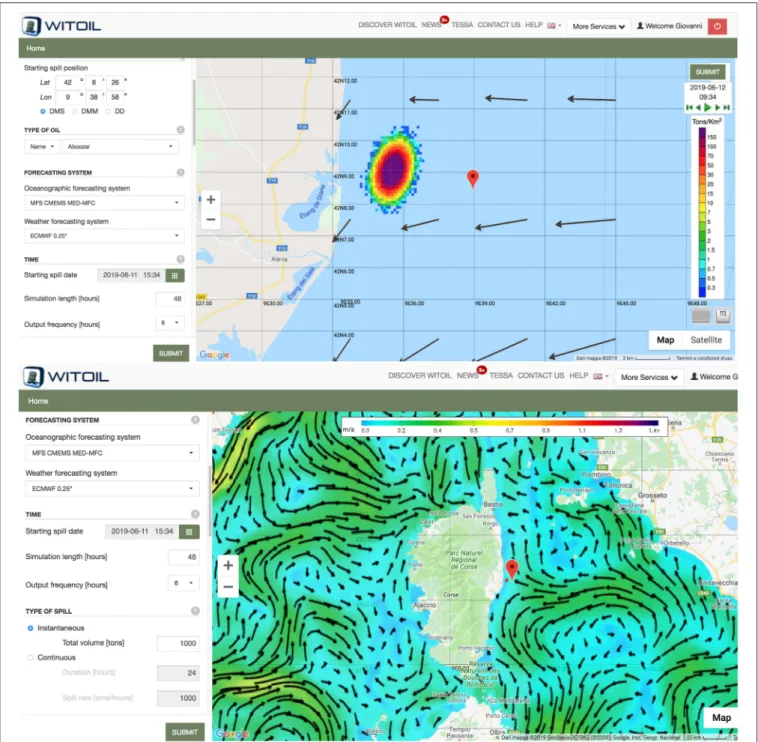
The CMEMS products support major scientific research and applications, including the evaluation of the sea level trend dynamics (Pinardi et al., 2014), the overturning circulation in the Mediterranean Sea (Verri et al., 2017; Pinardi et al., 2019), oil spill hazard mapping (Liubartseva et al., 2015) and an oil spill emergency response decision support system (Zodiatis et al., 2016a). Multi-year products (both reanalysis and hindcasts) at daily/monthly frequency are also regularly updated once per year and they cover by now the past 30 years. All operational products are made available through the CMEMS service delivery system9.
SOCIB
The Modeling and Forecasting Facility at SOCIB has successfully developed and implemented three prediction systems which are now run and evaluated on an operational daily basis.
These are: the operational regional circulation model nested to CMEMS Med-MFC (Juza et al., 2016; Mourre et al., 2018), the meteo-tsunami pre-operational forecasting system for Ciutadella harbor (Renault et al., 2011; Licer et al., 2017) and the wave forecasting around the Balearic Islands. Research is also conducted to continuously improve and extend the capacity of these systems. The most significant recent advances include a new characterization of the dynamics of ocean eddies in the Algerian basin (Escudier et al., 2016a) and the analysis of multi- year high-resolution numerical simulations to investigate fish
9http://marine.copernicus.eu/services-portfolio/access-to-products/
larvae dispersion (Calò et al., 2018) or simulate high-resolution observations potentially obtained from future satellites such as SWOT (Gómez-Navarro et al., 2018) and the application of machine learning techniques for the interpolation of simulated observations of satellite altimetry (Fablet et al., 2018).
Significant advances have been also achieved on the understanding and simulation of physical-biogeochemical processes, for example on the combined effects of the Atlantic Water inflow at Gibraltar and the associated eastward jet and winds over the phytoplankton distribution in the Alborán Sea (Oguz et al., 2016, 2017), and on the integration of multiplatform observations and high-resolution modeling through data assimilation (Pascual et al., 2017; Hernandez-Lasheras and Mourre, 2018). These results have implications in terms of operational response to emergencies, sustainable management of the marine environment and ecosystems health, and climate.
POSEIDON
Forecasting tools are centrally placed in the POSEIDON system, with a number of state-of-the-art weather, wind waves, ocean circulation and marine ecosystem numerical models, initialization and data assimilation schemes providing 5-days ahead information on daily basis regarding the atmospheric (Papadopoulos et al., 2002), sea state (Korres et al., 2011), and hydrodynamic conditions (Korres et al., 2010) in the Aegean/Ionian Seas and in the Mediterranean, in addition to the ecosystem functioning of the whole basin. In terms of general calibration, validation activities are applied to the operational models as data from the observatory are used in conjunction with experiments (e.g., mesocosms) for the analysis and modeling of specific processes (e.g.Tsiaras et al., 2017) and assimilation algorithms of sea color data are tested and validated in biogeochemical models (Kalaroni et al., 2016).
CYCOFOS
The Cyprus coastal ocean forecasting system, known as CYCOFOS, has been providing operational hydrodynamics and sea state forecasts in the Eastern Mediterranean since early 2002.
Recently, it has been improved with the implementation of a new hydrodynamic, wave and atmospheric modeling system with the objective of targeting larger and higher resolution domains, at regional and sub-regional scales (Zodiatis et al., 2016b). For the new CYCOFOS hydrodynamic modeling systems a novel parallel version of the Princeton Ocean Model has been developed and implemented with a 2 km resolution over the entire Eastern Mediterranean and in the Levantine Basin with a resolution of
∼600 m. Both models are nested in the CMEMS Med-MFC. The Weather Research and Forecasting atmospheric model (WRF) has been implemented in the same domain as the SKIRON atmospheric system10 (Kallos et al., 1997; Papadopoulos et al., 2002), to provide the backup forcing for the CYCOFOS new modeling systems.
All the CYCOFOS modeling systems received an extended cal/val against Argo profiles, satellite SST time series, in-situ wave time series and METAR observations (Zodiatis et al., 2018).
10http://forecast.uoa.gr
The CYCOFOS modeling system provides a higher-resolution quality-controlled forecasting data fit for the needs of end users in the fields of maritime safety and oil spill predictions, particularly in view of the recent exploration and exploitation of the hydrocarbons in the Eastern Mediterranean Levantine Basin. Over the past 10 years, the majority ofin-situobservations around Cyprus have been collected from two ocean gliders, which have been shown to improve the operational forecasting skill of CYCOFOS at scales from 10 to 50 km, most notably in the region of the Cyprus Eddy (Hayes et al., 2019).
SANIFS
The southern Adriatic Sea and Northern Ionian Forecasting System (SANIFS,Federico et al., 2017) is an unstructured grid limited area forecasting system downscaling the CMEMS Med- MFC forecasts up to 10 m along the coasts and inside the harbors.
SANIFS is based on a 3D finite element hydrodynamics model (Umgiesser et al., 2004) and it considers 91 vertical levels with a 2 m resolution to a 20 m depth, progressively decreasing the resolution near the bottom. Tidal forcing is applied to the lateral boundaries of the model so that the forecasts can be used for several coastal applications such as coastal erosion, inundation forecasts, and marine pollutants dispersal hazard mapping. The model is nested to CMEMS and forced with ECMWF products with a 6 h frequency and a∼12 km horizontal resolution. The results are available at the SANIFS site11.
PORTUS
The Portus forecasting component operates both at the regional scale, with sea level and wave forecasts covering the whole Mediterranean basin, and at the port and coastal scale, with forecasts of circulation (nested into CMEMS models) and waves.
At the regional scale, the sea level forecast is provided by a 2D barotropic model covering the whole basin, which has been recently complemented by a multi-model Bayesian model average ensemble based on Copernicus forecasts. The wave forecast is based on the using of WAM forced with Spanish Met Office winds. At the coastal and port scale, multiple models are used to provide high resolution services for ports and coastal areas (see description of SAMOA at section Puertos del Estado Downstream Services).
CAPEMALTA
CapeMalta is the ocean forecasting system for the Maltese Islands. The ROSARIO Malta Shelf forecasting system12 provides routine online thermo-hydrodynamic predictions for the extended area around the Maltese Islands up to the southern Sicilian coast. The system operates through the use of an eddy- resolving numerical model with two distinct spatial resolutions of 1/64o and 1/96o (about 1 Km) with 1-h and 3-h averaged color maps and animations of temperature, salinity and velocity fields at the sea surface and at selected depths, and a forecast horizon of 4 days. The MARIA Malta Atmospheric and Wave forecasting systems consist of an operational chain of meteo-marine models with downscaling to high resolution sub-domains for the region
11http://sanifs.cmcc.it/
12http://www.capemalta.net/MFSTEP/results.html