Polarforschung 88 (2), 135 – 150, 2018 (erschienen 2019)
Soils of the Lena River Delta, Yakutia, Russia:
Diversity, Characteristics and Humic Acids Molecular Composition
by Vyacheslav Polyakov1,2,3, Ksenia Orlova1 and Evgeny Abakumov1
____________
Keywords: The Lena River Delta, 13C-NMR spectroscopy, permafrost-affected soils, Arctic region, carbon pools.
doi:10.2312/polarforschung.88.2.135
1 Department of Applied Ecology, Faculty of Biology, St. Petersburg State University, 16th Liniya V.O., 29, St. Petersburg, 199178, Russian Federation;
2 FSBI “Arctic and Antarctic Research Institute”, Beringa 38, St. Petersburg, 199397 Russian Federation;
3 Department of Soil Science and Agrochemistry, Faculty of Agriculture, Saint-Pe- tersburg State Agrarian University, Petersburg Highway 2, Pushkin, St. Petersburg, 196601, Russian Federation.
Manuscript received 11. January 2018; accepted 11. September 2018
Abstract: Soils of the Lena River Delta were discussed in terms of morphology, diversity, main chemical, physical properties and HAs molecular composition. It was shown that the investigated soils are formed under the influence of several soil-forming processes, the processes of cryogenic mass exchange are considered as a main soil formation process, the second most important process is alluviation and formation of Umbric Cryosol (Fluvic, Arenic, Reductaquic) with pronounced features of soil stratification. Erosion of the floodplain and resedimentation on its surface of suspended particles in the water results in formation of stratified soils, underlain by solums with well-expressed cryogenic features. Soils of the delta are characterized by high amount of carbon, accumulated in fine earth, and well-expressed formation of folic horizons in topsoil layers. Texture soil classes were represented by four categories: sand, loamy sand, sandy loam and silt loam. This suggests a large amount of alluvium deposits in the delta and that settling of large particles results from fast river flow. Humic acids of selected soils were investigated in terms of elemental and structural composition with special reference to evalu- ation of organic matter stabilization degree and assessment of carbon species distributions in the molecules with use of solid-state 13C-NMR spectroscopy.
It was shown that the prevailing of aromatic compounds on the aliphatic one is more pronounced in the Lena River Delta than in other Arctic soils.
Zusammenfassung: Die Böden des Lena-Deltas wurden hinsichtlich ihrer Morphologie, Diversität, den wichtigsten chemischen und physikalischen Eigenschaften sowie der molekularen Zusammensetzung der Huminsäuren untersucht. Es wurde nachgewiesen, dass die Böden des Lena-Deltas unter dem Einfluss von verschiedenen bodenbildenden Prozessen entstanden sind.
Hierbei stellen die Prozesse des kryogenen Masseaustauschs den wichtigsten Bodenbildungsprozess dar, gefolgt von Anschwemmung und Bildung von Fluvisolen mit ausgeprägten Merkmalen einer Bodenschichtung. Die Erosion des Überschwemmungsgebiets und die Resedimentation von in Wasser gelösten Partikeln auf deren Oberfläche resultiert in der Bildung von geschich- teten Böden, deren Unterlage von Sola A- und B-Horizonten mit deutlich ausgeprägten kryogenen Merkmalen geprägt ist. Die Böden des Deltas sind durch eine große Kohlenstoffmenge geprägt, akkumuliert in Feinerde und deutlich ausgeprägter Ausbildung von histischen Horizonten in den Oberbo- denschichten. Bodengefügeklassen sind in vier Kategorien vertreten: Sand, lehmiger Sand, sandiger Lehm und sandiger Lehm. Dies deutet auf eine große Menge an Alluvialböden, die im Delta abgelagert werden. Die groben Partikelgrößen sind das Ergebnis hoher Fließgeschwindigkeit des Flusses.
Huminsäuren ausgewählter Böden wurden hinsichtlich ihrer Element- und Strukturzusammensetzung untersucht, unter besonderer Berücksichtigung der Bewertung des Stabilisierungsgrades des organischen Materials und der Erfassung der Verbreitung der Kohlenstoffarten in den Molekülen mit Hilfe der Festkörper-13C-NMR-Spektroskopie. Es konnte gezeigt werden, dass das Überwiegen aromatischer gegenüber aliphatischer Komponenten im Lena- Delta stärker ausgeprägt ist als anderswo in der Arktis.
INTRODUCTION
Soils, located in permafrost-affected terrestrial ecosystems of the cryolithozone are known as very diverse in terms of morphology, profile organization and main chemical and physical properties. The area of the distribution of perma- frost on the Earth reaches 35 million km2, accounting for up to 25 % of the world’s total land area (Jones et al. 2010).
Specific signs of permafrost are the negative temperature and the presence of ice, characteristic of frozen layers for a long time (Konischev 1997). In Eurasia, permafrost occu- pies about 13 million km2 and extends from circumpolar latitudes to 44°N. In Russia, permafrost occupies more than 10.7 million km2, which is about 65 % of the country’s terri- tory. The most widely permafrost is widespread in the north of Western Siberia, in Eastern Siberia, and in Transbaikalia.
One of the most likely and important feedback from sustain- able warming in high-latitude ecosystems is the thawing of permafrost soils and the release of soil organic carbon into the atmosphere through the microbial respiration of CO2
or methane, or by leaching out as dissolved organic carbon (Dutta et al. 2006). Soil organic matter is among the largest global reservoir that exchanges carbon with the atmosphere, it is an important reservoir for a large fraction of the global soil carbon pool (Dutta et al. 2006, schimel 1995, Davis 2001). This pool of soil carbon, climatically protected by cold and waterlogged conditions, is thought to be highly susceptible to change in temperature and permafrost thawing (Bischoff et al. 2013).
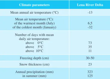
Soils that are belonging to the cryolithozone, including soils of the Lena River Delta, form under influence of severe arctic polar climate, which are characterized by negative average annual temperatures (-13°С) and low average perspiration (about 323 mm). Climate description for the study regions is given in Table 1. Vegetation cover is represented by tundra associations: grass-sedge-moss community are preva- lent, moss-sedge polygonal wetlands locate in the low areas (Bolshiyanov et al. 2013). This results in the formation of soil profiles with well pronounced features of cryogenic mass exchange. On the other hand, soil formation in the Lena River Delta is strongly affected by fluvic processes, related to allu- vial activity of the river.
Soils of floodplains can be divided to young soils of recently formed areas (coast shallows, overgrown by vegetation bodies of water) slightly affected by soil forming processes and relatively older soils of the areas drifted away from the floodplain processes influence and are covered by developed soils with signs of indicative features of zonal soil formation (DoBrovolsKy 1994, 2005, BoiKe et al. 2013, KutzBach et al. 2004).
In the floodplains, soil formation takes place under the action of soil forming several factors: alluvial, floodplain and zonal processes (DoBrovolsKy et al. 2011). Alluvial processes are sediments transportation by an action of water, erosion of a floodplain, redeposition of sediments within a floodplain.
Floodplain processes are flooding of different areas of flood- plain by water which considers fine-grained sandy and clay material (DoBrovolsKy 2005). Zonal process of soil forma- tion in the arctic zone is cryogenesis (cryogenic mass transfer and exchange, gleification (stagnification) redistribution of organic matter (GuBin et al. 2008).
The characteristic features of the Arctic region are continu- ously frozen ground (permafrost), extensive wetlands with shallow lakes and ponds, large seasonal fluctuations in solar energy, and a short vegetation period (BoiKe et al. 2013).
Rivers of high latitudes serve as a link between soil carbon pools, atmosphere, and Arctic Ocean shelf. They play a key role in redeposition and transformation of carbon, which is received to the ocean (zimov et al. 2006). The Lena River flows into the Laptev Sea and has a great impact in the Arctic Ocean. The River is one of the major receivers of organic and inorganic carbon and defines the organic carbon cycle in the Arctic basin in many ways. (lara et al. 1998).
Particular attention is being paid to the influence of the river flow on exchanging processes between the atmosphere and the ocean and formation of the planetary maximum of green- house gases accumulating in the high latitude (Dutta et al.
2006). The consequences of current and future warming of arctic climate will be stronger than the average worldwide.
In response to arctic warming, the area of permafrost land- scapes will decrease, and the thickness of the active layer will increase. Then organic carbon, that was frozen in permafrost, will become available for microbial degradation, resulting in the formation of carbon dioxide (CO2) and methane (CH4) (KnoBlauch et al. 2013, WaGner et al. 2007).
It is essential, therefore, to investigate regional soil diver- sity that locates in conditions of continuous redeposition of materials and matters and cryogenic processes that are being
actively developed. Arctic soils and peatlands act as large carbon stocks, but our understanding of feedback mecha- nisms caused by rising temperatures and their effect on trace gases remains has not been studied (BoiKe et al. 2013). The distinctive properties of deltaic soils of the north of Russia are: abundance of non-humified organic matter, low micro- biology activity of soil microorganisms, a large amount of Fe+2 compounds and low mobility of phosphorus and potas- sium in the soil complex, as well as a low content of humus, in comparison with soils that do not undergo flooding (DoBrovolsKy et al. 2011). Soils are characterized by a low activity of microorganisms at a high potential of microflora in flooded areas. This is due to the fact that delta soils have a high potential biological activity, which is associated with the annual intake of nutrients coming from the hollow waters of the river. The decomposition processes reach a peak in the upper horizons of the soil and weaken down the profile. In conditions of constantly excessive moisture and high-water capacity, it is very often possible to observe stagnant moisture and undifferentiated organic residues in the profiles. In such soils, the valence of iron changes from Fe+3 to Fe+2. There is a large number of compounds of phosphorus and sulfur in the soil complex (DoBrovolsKy 1994).
A significant amount of carbon of organic compounds accu- mulates in the soils of the Lena River Delta. The organic matter presents various properties to the type of humus content of soils, depending on the location in the relief. In connection with this, it is important to study the humic acids of the soils of the Lena River Delta, using the method of nuclear magnetic resonance.
The advantage of this method is the ability to quantify the content of groups of structural fragments and identify indi- vidual structural fragments in humic acid molecules and is also used to assess changes in SOM during decomposition and humification. So far, studies of the quality of SOM from polar environments have revealed a generalized low-degraded nature of organic molecules that retain most of the chemical nature of their precursor material due to the low progress of humification (DaviDson & Janssens 2006, DziaDoWiec et al.
1994, aBaKumov et al. 2015).
The investigation of the Lena River Delta soils was elaborated through the four characteristics:
1. The pedodiversity in the different landscapes positions.
2. The morphological and chemical diversity in different parts of the Lena River Delta.
3. Research of the major ecological functions of the study region.
4. Estimation of the rate of stabilization of soil organic matter using precise molecular methods.
MATERIALS AND METHODS The study sites
Materials for this study were collected during two expeditions within the project “Lena River Delta” in 2015-2016, organized by the Arctic and Antarctic Research Institute, St. Petersburg.
Tab. 1: Climate parameters of the study region (Data obtained from the station
“Samoylov Island”)
Tab. 1: Klimatische Parameters des Untersuchungsgebiets (Daten von der Station „Samoylov Island“ erhalten)
Climate parameters Lena River Delta Mean annual air temperature (°C) -13
Mean air temperature (ºC):
of the warmest month (July)
of the coldest month (January) 6,5 -32 Number of days with mean
daily air temperature:
above 0°С above 5°С above 10°С
7335 11
Freezing depth (cm) 30-50
Snow thickness (cm) 23
Annual precipitation (mm)
in summer (mm) 323
125
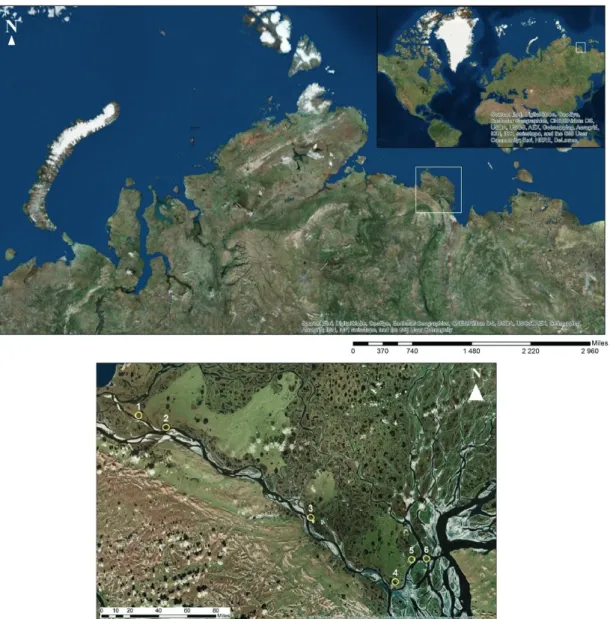
The Lena River Delta is the largest northern delta in the World, which is located in the Arctic zone and covers around 29630 km2. The delta has a great influence on water regime and biogeochemical state of the Arctic Ocean due to its huge area and disposition. The delta supplies a great amount of fresh water to the least salty ocean of our planet. The delta resulted from river activity: redeposition of sediments, erosion, and abrasion due to fluctuations of sea level and crust movements (Bolshiyanov et al. 2013, BoiKe et al. 2013, zuBrzycKi et al.
2014) (Fig. 1).
Eastern and western parts of the delta are different in terms of density of river network and the number of islands and their sizes. Thus, the western part of the delta has a density of river network 0.13 km/km2 and is represented by large-size islands,
Fig. 1: The key study sites of the Lena River Delta, Russian Arctic. Investigation sites. Distribution of soils within investigation area: 1) isl. Hardang (Folic Cryosol; Reductaquic); 2) isl. Hardang (Umbric Cryosol; Loamic, Reductaquic); 3) isl. Jan-Gylach (Cryosol; Oxyaquic, Loamic, Reductaquic); 4) isl. Kurungnagh (Turbic Cryosol; Loamic, Reductaquic); 5) isl. Kurungnagh (Folic Cryosols; Reductaquic, Subaquatic); 6) isl. Samoylov (Umbric Cryosol; Fluvic, Arenic, Reduc- taquic).
Abb. 1: Untersuchungsstandorte im Lena-Delta, russische Arktis, und Verteilung der Böden innerhalb des Untersuchungsgebiets: 1) Hardang-Insel (Folic Cryo- sol (Reductaquic); 2) Hardang-Insel (Umbric Cryosol; Loamic, Reductaquic); 3) Jan-Gylach-Insel (Cryosol; Oxyaquic, Loamic, Reductaquic); 4) Kurungnagh- Insel (Turbic Cryosol; Loamic, Reductaquic); 5) Kurungnagh-Insel (Folic Cryosols; Reductaquic, Subaquatic); 6) Samoylov-Insel (Umbric Cryosol; Fluvic, Arenic, Reductaquic).
that have the high heights of the surface. The largest island of the western part of the delta: Arga-Muora-Sisyo (18 % of the total area of the delta), Hardang-Sisyo (1136 km2), Kurungnag (355 km2) and Jangylah (169 km2), the total number of islands in the western part of the delta amounts to 235 (Bolshiyanov et al. 2013).
The environmental peculiarities of the eastern part of the delta are entirely different from the conditions in the western part due to river flow activity and the northeastern direction. As a result, the eastern part is represented by a lot of islands – 764.
A density of river network is 0.34 km/km2, the territory of the eastern part of the delta is riddled with a network of numerous flows that destroy materials, redeposit the sediments and form small area islands (Bolshiyanov et al. 2013, GalaBala 1987).
Moreover, sea waters affect the delta. Western and north-
western coasts are under influence of Laptev Sea, the surface sea temperature here is much lower than on eastern and north- eastern coasts. There temperature defines by the Lena River warm flow. The temperature in August on the western coast is 3°С, on the eastern coast – from 4 to 9°С. In addition to phys- ical properties, chemical properties also changes, sea waters activity affects the salinity which reached 14 ‰ in the western and northwestern parts of the delta.
The territory of the delta includes at least 27165 lakes over 0.25 km2 and 10 lakes over 10 km2. Most of the lakes are concentrated in the western part of the delta, that due to the fact this part of the delta is the oldest and the largest islands are located here. In the eastern part lakes related to the riverbed lakes and oxbow lakes dominate. A large amount of water passes through the Lena River Delta, annual average discharge is 15400 m3/s, annual sediments run-off is 5.8 1013 g. Turbidity of the water is 23 g/m3 (Bolshiyanov et al. 2013, GalaBala 1987, ivanov 1963).
Vegetation cover is represented by tundra species: grass- sedge-moss community are prevalent, moss-sedge polyg- onal wetlands locate in the low areas. Vegetation cover is not continuous but spotted. The Lena River Delta is char- acterized by the domination of moss-lichen vegetation.
Moss community predominates on loamy soils, and lichens – on the coarse rocky soils. Near the lakes of glacier origin, sedge-cotton grass groups replace moss-lichen vegetation.
On the warm southern slopes on the well-drained rocks covered by sandy soils, there are areas with grass commu- nity (floodplain and tundra meadows). With different posi- tions in the relief certain types of vegetation are associated, so to the wet tundra (wet central parts of polygons, negative forms of relief) relate: Drepanocladus revolvens, Meesia triquetra, Rhizomniumpunctatum, Calliergongiganteum, Carexchordorrhiza, Comarum palustre, Pedicularis sudetica.
Dry tundra (well-drained locations) is covered by: Hylocomium splendens, Dryas punctata, Peltigera, Polygonumviviparum, Saxifragapunctata, Astragalusfrigidus, Luzulatundricola, Lagotisglauca, Saxifragahirculus, Valeriana capitata. Flood- plain meadows: Salix glauca/reptans/lanata, Equisetum sp., Alopecurus alpinus, Festuca rubra, Deschampsia borealis.
Flooded sites of small lakes – Arctophila fulva (BoiKe et al.
2013, KutzBach et al. 2004, schneiDer et al. 2009).
The Lena Delta can be divided in three different geomor- phic terraces with an active seasonal flooded level. The active seasonal flooded level is the first terrace (1-12 m) this is the youngest part of the river delta. The first terrace was formed during the Middle Holocene and is mainly repre- sented in the eastern part of the Lena Delta. The second terrace (12-30 m) formed in the interval between the late Pleistocene and the early Holocene and it includes about 23% of the delta area and is characterized by sand fractions containing and a small amount of ice. The polygonal relief is less pronounced, the most typical feature for this area is a large number of thermokarst lakes. The third terrace (30-60 m) is the oldest terrace in the Lena Delta. It does not belong to a river delta block, it is an erosion residue of the late Pleistocene, consisting of a fine-grained, containing organic matter, ice-covered material that accumulated in front of the Chekanovsky and Kharulakh mountain ridges. The surface of the third terrace is characterized by a polygonal terrain, due to the formation of
ice veins and a network of permafrost tundra polygons, with developed thermokarst processes (Bolshiyanov et al. 2013, schWamBorn et al. 2002).
The key areas
The key areas of the study are the islands of the southwestern and central parts of the Lena River Delta. The study sites are located along the Olenek channel on the third terrace and include the islands: Hardang (N 72.46 E 123.56), Ebe-Ba- sin-Sisse (N 72.54 E 123.15), Jan-Gylakh (N 72.30 E 125.16) (Fig. 2). The island of Hardang and Ebe-Basin-Sisse is a sandy-silty stratum up to 25 m. Sands and aleurites are hori- zontally-layered or wavy-layered, which indicates sedimenta- tion in the basin. The ice component is small and it is present in the form of cement. The island of Jan-Gylakh is composed of quartz fine-grained yellowish-gray sands, stratification is predominantly horizontal. Samoilovsky Island (N 72.370 E 126.467), where the Research center “Samoilovsky” is based, is located on the first terrace and periodically submerged by river water. The island covers an area of about 5 km2. The western part is formed by recent channel reshaping and aeolian processes. Eastern part with ice veins and small thermokarst lakes. The islands consisting of heterogeneous sediments are typical for the Lena Delta, this geological structure indicates a change in the sedimentation both in the lateral vector and in time.
Hardang Island (N 72.46 E 123.56) is located in the western part of the delta, 45 m.a.s.l., on top hill is composed the ice complex, with a moss cover. A specific relief is formed due to erosion from the river side and in the inner parts of the island (along the edges of thermokarst basins and local erosional thermokarst valleys). The ice complex is underlain by hori- zontally layered quartz sands and siltsoils containing plants residues, there are inclusions of ice veins, in some layers, small pebbles of quartz, jasper, carnelian are accumulated, as a result of aeolian processes of sand destruction (Bolshiyanov et al. 2013).
Ebe-Basin-Sise Island (N 72.54 E 123.15), the western part of the delta, the ice complex is also located on top and under- lain by alternately changing layers of sands and silt soils, with plants residues in the form of detritus. The sands are horizon- tally-layered and wavy-layered, this indicates the accumula- tion of precipitation in basin (Bolshiyanov et al. 2013).
The island of Jan-Gylakh (N 72.30 E 125.16) is a continua- tion part of the Kurungnakh Island, separated by a small canal, up to 40 meters high, on top is composed by the ice complex underlain by sands and siltsoils (Bolshiyanov et al. 2013).
Sampling strategy and procedure
The soil samples were taken taking into account the spatial picture of the vegetation cover and the position in the land- scape. Samples of soil were selected in various elements of the landforms. Several profiles were made in the areas subject to annual flooding and the places of the already-released condi- tions. The depth of the soil pits reached 79 cm for Umbric Cryosol (Fluvic, Arenic, Reductaquic) and up to 50 for the
other soil types. Soil profile was located in various elements of the landscape. They served: micro depressions, hills, flooded areas, slopes of terraces.
Chemical and physical methods
The dried samples were grounded passed through a 1 mm sieve. Soil samples were selected for each horizon to analyze physical and chemical properties. Analyses were conducted in the certified laboratory of St. Petersburg State University at the Department of Applied Ecology, Russia. Soils were analyzed according to the following methods: determina- tion of actual acidity (pHH2O), potential acidity CaCl2), by a stationary pH meter in aqueous solution and 1N CaCL2 solu- tion, respectively. The microbiological activity of soils, the basal respiration, using incubation chambers was determined (KimBle & follett 2001). The humus content estimated based on the ratio Cha/Cfa (KimBle & follett 2001). To evaluate the volumetric content of carbon in the fine earth we had used data of “dry combustion” (Ссо2). The determination of Cco2 is based on sample direct combustion and further eval- uation of emitted CO2 by chromatography. During oxidation all the organic carbon turns into carbon dioxide. Further on, in resulting products of combustion utilized from chlorides and other halogens, the measurement of carbon dioxide takes place (aBaKumov & PoPov 2005). Cco2 and N content were deter- mined using an element analyzer (Euro EA3028-HT Analyser) with dry combustion procedure.
Humic acids were extracted according to the standard proce- dure (schnitzer 1982). Solid-state 13C-NMR spectra of humic acids were measured with a Bruker Avance 500 NMR spec- trometer (Karlsruhe, Germany, 2003) in a 4-mm ZrO2 rotor.
The groups of structural fragments were identified by the magnitude of the chemical shift (chefetz et al. 2002). This is very important since polar soils are characterized by a specific composition of humification precursors. Humic acids were extracted from five soil samples: (1) Cryosol (Oxyaquic, Loamic, Reductaquic); (2) Folic Cryosol (Reductaquic); (3) Umbric Cryosol (Loamic, Reductaquic); (4) Turbic Cryosol (Loamic, Reductaquic); (5) Cryosol (Oxyaquic, Loamic, Reductaquic) (Fig. 6). Samples were taken from the upper soil horizons from Kurungnakh Island, the central part of the Lena River Delta, and from the Stolb Island, remains of the bedrock relief, where the process of humification is most active. All soils belong to the third terrace (ice complex) and are not involved in the annual flooding process. Samples were selected from the upper horizons of soils, where the process of humification is the most intensive.
RESULTS AND DISCUSSION Soil morphology and diagnostics
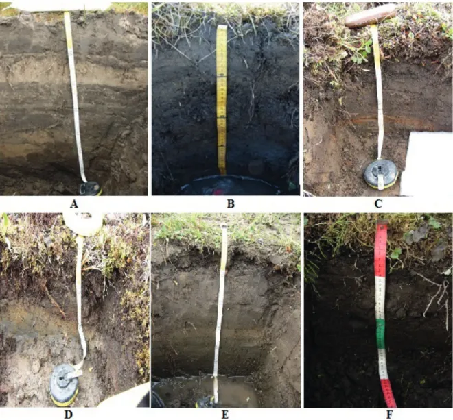
Diagnostics of the soils, conducted according WRB has shown that they belong to the following types: Umbric Cryosol (Fluvic, Arenic, Reductaquic), Turbic Cryosol (Loamic, Reductaquic), Folic Cryosol (Reductaquic), Folic Cryosols (Reductaquic, Subaquatic), Umbric Cryosol (Loamic, Reduc- taquic), Cryosol (Oxyaquic, Loamic, Reductaquic) (Table 2) (WorlD reference Basefor soil resources 2014).
The allocation of each type of soil depends on certain condi- tions of formation: the position in the landscape, remote- ness from the floodplain, humidification degree, vegetation, activity of cryogenic processes that produce cryoturbated horizons, frost heave, thermal cracking, ice segregation and patterned ground microrelief.
Soils confined to the delta area develop under the influence of two groups of factors, alluvial and cryogenic processes. The following types of soils develop on recently formed parent material without the introduction of fresh river alluvium:
Umbric Cryosol (Loamic, Reductaquic) the soils have recently emerged from the regime of the seasonal flood and are char- acterized by a one humus horizon, located in the topsoil.
The transitional horizon as an separated genetic formation is not expressed (Fig. 2e). Appearance signs of gley processes, related to stagnification on the suprapermafrost layer was pronounced in many of soils investigated on the border with permafrost, the ground water is high. The soils developed on rocks of alluvial origin of a light texture class. Cryogenic mass transfer is observed. The flora is represented by the same species as in Umbric Cryosol (Fluvic, Arenic, Reductaquic).
The next type of soil developing in the delta of the Lena River is associated with the accumulation of iron and aluminum at the contact border with permafrost, this type is character- ized by an reddish color forming under oxidative conditions.
Cryosol (Oxyaquic, Loamic, Reductaquic) develop on rocks of light texture class (Fig. 2f). The texture class of the soil is sandy loam, the color is fawn, crumb-like structure, appear red and brown spots. Signs of gleyic and cryogenesis processes develop in the horizons near the permafrost. Flows of humus and cryogenic mass transfer near the permafrost table are observed. The vegetation cover represented by Drepanocladus revolvens, Meesia triquetra, Rhizomnium punctatum, Calliergon giganteum, Carex chordorrhiza, Comarum palustre, Pedicularis sudetica.
Another type – Turbic Cryosol (Loamic, Reductaquic): the soils develop on well-drained territories, but there are also signs of gley on contact with permafrost. The soils have a grayish-brown color, the texture class is represented by silty loam, has a crumb-like structure, red spots are present (Fig. 2b). On the contact border with permafrost form on the suprapermafrost horizon a geochemical barrier that serves as a site for accumulation of organic-mineral compounds.
Ice cracking, cryoturbation, thixotropy is observed. Flora is represented by the following species: Hylocomium splendens, Dryas punctata, Polygonum viviparum, Saxifraga punctata, Astragalus frigidus, Luzula tundricola, Lagotis glauca, Saxifraga hirculus, Valeriana capitata.
Folic Cryosols (Reductaquic, Subaquatic) develop under conditions of over humidification, occupying local meso- and micro-depressions (Fig. 2d). Characterized by the presence of a Folic horizon underlain by the Cryic horizon. The color is dark gray with bluish spots, light – medium loam, crumb- like structure. Patterned ground microrelief, flow of humus and iron along the profile is observed. Flora is identical to the species developing on the Folic Cryosol, mosses predominate.
Folic Cryosol (Reductaquic) develop on the drained positions, characterized by the presence of a surface Folic horizon of
Soil Horizon Depth Soil horizon description Location, vegetation description, Total vegetation cover (TVC) and individual cover of some plants,
inclusions,coordinates, height m.a.s.l.
Umbric Cryosol (Fluvic, arenic, Reductaquic)
(a)
Umbric 0-7 7,5 YR 7/3 sandy loam, roots
Samoylov isl., first-terrace, TVC 90%, Salix glauca/reptans/lanata 90%, Equisetum sp. 10%,
N 72,37085 E 126,46750, 3 m.a.s.l., Permafrost table from 70 cm, the water table is 63 cm.
Cryic 7-12 7,5 YR 6/3 loam, roots
Umbric 12-22 7,5 YR 8/3 sand, roots
Cryic 22-41 7,5YR 6/3 loam, roots
Umbric 41-47 7,5 YR 7/4 sand, roots
Cryic 47-70 7,5 YR 5/3 loam, wet,
rusty spots Umbric Cryosol
(Fluvic, arenic, Reductaquic)
(b)
Umbric 0-17 7,5 YR 7/3 sand Samoylov isl., first-terrace, TVC 95%,
Salix glauca/reptans 70%, Alopecurus alpinus 30%, N 72.37206 E 126.46976, 4 m.a.s.l., Permafrost table from 79 cm, the water table is 65 cm Cryic 17-79 7,5 YR 8/3 stratified sand of
different sizes, roots
Turbic Umbric Cryosol (Loamic, Reductaquic)
(a)
Umbric 0-14 10 YR 3/2 organic mattr Kurungnagh isl., third-terrace, TVC 95% Hylocomium splendens 70%, Timmia austriaca 15%, Dryas punctata 8%,
Polygonum viviparum 7%, N 72.37550 E 126.24898, 21 m.a.s.l., Permafrost table from 18 cm,
the water table is 16 cm Cryic 14-18 10 YR 6/1 loam, rusty spots
Turbic Cryosol (Loamic, Reductaquic)
(b)
O 0-7 10 YR 4/3 organic matter
Kurungnagh isl., third-terrace, TVC 90%, Hylocomium splendens 70%, Timmia austriaca 30%,
N 72.47421 E 126.23158, 60 m.a.s.l., Permafrost table from 35 cm, the water table is 34 cm Cryic(1) 7-16 7,5 YR 4/3 sandy loam roots
Cryic(2) 16-27 10YR 6/3 loam, oxidized Cryic(3) 27-35 10YR 6/1 loam, oxidized Folic Cryosol
(a) Folic 0-18 10YR 3/2 organic matter
Hardang isl., third-terrace, TVC 100%, Hylocomium splendens 70%, Timmia austriaca 15%,
Climacium dendroides 15%, N 72 46,637 E 123 56,946, 23 m.a.s.l., Permafrost table from 18 cm, the water table is 17 cm Folic Cryosol
(Reductaquic) (b)
Foilic 0-8 10YR 4/3 organic matter Kurungnagh isl., third-terrace, TVC 100%, Hylocomium splendens 70%, Timmia austriaca 30%,
N 72.47643 E 126.27939, 66 m.a.s.l., Permafrost table from 20 cm, the water table is 19 cm
Cryic 8-20 10YR 3/2 oxidized
Folic Cryosols (Reductaquic, Subaquatic)
(a)
O 0-7 10 YR 4/3 organic matter Kurungnagh isl, third-terrace, TVC 100%, Hylocomium splendens 70%, Timmia austriaca 30%,
N 72,32508 E 126,26555, 56 m.a.s.l., Permafrost table from 25 cm, the water table is 23 cm
Folic 7-20 7,5 YR 6/3 loam, roots
Cryic 20-25 Gley 2 6/10BG loam, rusty spots Folic Cryosols
(Reductaquic, Subaquatic)
(b)
Folic 0-5 10YR 4/3 organic matter Kurungnagh isl, third-terrace, TVC 100%, Hylocomium splendens 70%, Timmia austriaca 30%,
N 72.35526 E 126.21431, 43 m.a.s.l., Permafrost table from 30 cm, the water table is 25 cm Cryic 5-30 Gley 2 5/10BG loam, rusty spots
Umbric Cryosol (Loamic, Reductaquic)
(a)
О 0-7 10YR 4/3 organic matter Hardang isl., third-terrace, TVC 76%,
Salix glauca/reptans/lanata 80%, Festuca rubra 10%, Deschampsia borealis 10%,
N 72 46.530 E 123 46.874, 10 m.a.s.l., Permafrost table from 60 cm,
the water table is 55 cm Umbric 7-30 7,5 YR 7/3 sandy loam, roots
Cryic 30-60 7,5 YR 6/1 sandy loam, rusty spots
Umbric Cryosol (Loamic, Reductaquic)
(b)
Umbric 0-6 7,5 YR 7/1 sand Kurungnagh isl., third-terrace, TVC 75% Salix glauca/rep- tans/lanata 70%, Alopecurus alpinus 15%, Festuca rubra 15%, N 72.34949 E 125.94101, 30 m.a.s.l.,
Permafrost table from 55 cm, the water table is 53 cm Cryic 6-55 7,5 YR 4/1 loam, rusty spots
Cryosol (Oxyaquic, Loamic,
Reductaquic) (a)
Cryic(1) 0-15 7,5YR 7/3 sandy loam, roots Jan-Gylach isl., third-terrace, TVC 70%, Drepanocladus revolvens 70% , Meesia triquetra 15%,
Rhizomnium punctatum 15%, N 72 30.831 Е 125 16.474, 25 m.a.s.l., Permafrost table from 60 cm, the water table is 57 cm Cryic(2) 15-28 7,5YR 6/4 rusty streaks
Cryic(3) 28-60 10YR 6/3 loam, rusty spots Cryosol
(Oxyaquic, Loamic, Reductaquic)
(b)
Cryic(1) 0-18 7,5 YR 7/3 sandy loam, roots Kurungnagh isl., third-terrace, TVC 73%, Drepanocladus revolvens 60%, Carex chordorrhiza 20%,
Comarum palustre 15%, Pedicularis sudetica 5%, N 72.35070 E 125.95138, 19 m.a.s.l., Permafrost table from 35 cm, the water table is 33 cm Cryic(2) 18-35 7,5YR 4/3 loam, rusty spots
Tab. 2: Locations where soil and vegetation samples were collected, Samoylov isl., Kurungnagh isl., Hardang isl., Jan-Gylach isl.
Tab. 2: Standorte, an denen Boden- und Vegetationsproben entnommen wurden: Samoylov-Insel, Kurungnagh-Insel, Hardang-Insel, Jan-Gylach-Insel
different composition, which is underlain by permafrost-af- fected soils (Fig. 2c). In the soils occur the processes of organic formation and organic accumulation. A color is dark gray, the profile contains organic remains of varying degrees of decom- position, appear signs of gleying on the contact border with permafrost. Thermal cracking is observed. Flora is represented by typical tundra species and is identical to the species of Turbic Cryosol (Loamic, Reductaquic)s, with the exception, here the mosses occupy the most percentage of cover.
The soils of the Lena River Delta develop under the influence of several processes: the alluvial and zonal processes of soil formation (peat formation, gleying and cryogenesis). There- fore, the soil diversity of the Lena River Delta is represented by the following types: Umbric Cryosol (Fluvic, Arenic) – the youngest soils of the delta, develop under the conditions of the alluvial process, the constant resedimentation of fresh river alluvium and prolonged flooding during the high water period.
Umbric Cryosol (Loamic, Reductaquic) – not so far away came out from under the influence of alluvial and seasonal flooding processes. Characterized by a single humus-accumulative horizon as a result of the alluvial accumulation of material.
Cryosol (Oxyaquic, Loamic, Reductaquic) are characterized by the presence of organic-mineral complexes with ferrum and aluminum in the middle horizon, and their migration within the soil profile. Turbic Cryosol (Loamic, Reductaquic) are associated with actively implemented cryogenic processes, spots formation, cryogenic mass change, thixotropy, solifluc- tion, thermokarst. These soils are zonal in the Arctic subzone and are formed in the river delta on the third terrace. Folic Cryosol (Reductaquic) are characterized by the accumulation of organic remains in the profile and its appearing in perma- frost, these soils are also zonal. Folic Cryosols (Reductaquic, Subaquatic) are characterized by the gley horizon on contact with permafrost. Soils are the oldest in the Lena River Delta and develop on the top of the third terraces.
Fig. 2: Morphological diversity of soils in the Lena River Delta: A- Umbric Cryosol (Fluvic, Arenic, Reductaquic), B- Turbic Cryosol (Loamic, Reductaquic), C- Folic Cryosol (Reductaquic), D- Folic Cryosols (Reductaquic, Subaquatic), E- Umbric Cryosol (Loamic, Reductaquic), F- Cryosol (Oxyaquic, Loamic, Reduc- taquic).
Abb. 2: Morphologische Diversität der Böden im Lena-Delta: A- Umbric Cryosol (Fluvic, Arenic, Reductaquic), B- Turbic Cryosol (Loamic, Reductaquic), C- Fo- lic Cryosol (Reductaquic), D- Folic Cryosols (Reductaquic, Subaquatic), E- Umbric Cryosol (Loamic, Reductaquic), F- Cryosol (Oxyaquic, Loamic, Reductaquic).
Umbric Cryosol (Fluvic, Arenic, Reductaquic) develop on the areas that annually are flooded and characterized by the alluvial accumulation of the material, mostly stratified (hori- zontal and wavy-horizontal) (Fig. 2a). The layers differ in color, the texture class, and structure that is associated with the power of the water flow, the faster the water flow, the large particles (sand) deposit, small particles (dust and silt) deposit when the flow is slow. The texture class is sandy-loam, color from dark gray to gray, non-structure, borders horizontal, wavy-horizontal. Also, the soil’s chemical properties vary within the profile (which is up to 79 cm); organic carbon is redistributed in the soil, has a powerful profile up to 79 cm, signs of gleyic stagnification appear on contact border with permafrost (permafrost affected soils). This type of soil is the youngest formation in the delta. The vegetation cover is characterized by the following species: Salix glauca/reptans/
lanata, Equisetum sp., Alopecurus alpinus, Festuca rubra, Deschampsia borealis.
Soil chemical characteristics
The soils of the Lena River Delta are characterized by acidic (4.5-5.5), slightly acidic (5.5-6.5) and neutral (6.5-7) and slightly alkaline (7-7.5) conditions. Neutral and slightly acidic conditions are related to the presence of carbonates in the middle and in the lower river flow that are transported here along with the sedimentary matter fluxes (cauWet & siDorov 1996). The acidic reaction is confined to the humus hori- zons and the layer on the border with the permafrost, where a geochemical barrier arises. A slightly alkaline reaction arises because of the proximity of the sea, the process of impulver- ization (brought by wind into the phytocenosis of sputtered mineral and organic substances) and the transfer of salts from the sea to the flooded areas of the soil occurs.
Depending on the landscape, and geochemical state of the pedoenvironment the soils differ from each other by pH range.
Thus, for soils forming in the area of the first, flooded terrace, are characterized by the inflow of saline waters from the sea and alkalization. The soils that are no longer involved in the alluvial and seasonal flooding processes are acidic inside the profile and slight alkalization on the surface that is associated with the process of pulverization.
The soils is an important natural reservoir and the most significant source of biogenic carbon in terrestrial ecosys- tems Soils usually play an important role in stabilization of carbon and this feature is known as most pronounced in soils of cryolithozone. Soil CO2 emission (soil respiration) includes the processes of microbiological decomposition of organic substances and autotrophic respiration of the roots. The emis- sion of carbon dioxide is a summary (generalizing) indicator of the biological activity of soils. The rate of carbon dioxide production by soil – basal (microbial) respiration is one of the important indicators of the state of microbiocenoses of soils (Table 3).
The rate of the emission of carbon dioxide is related to the amount of available biogenic elements and to soil microcli- mate of the soil (ivashchenKo et al. 2014, KnoBlauch et al. 2015, ananyeva et al. 2011). The most active emission is observed in the upper horizons of the soil, where a large number of biological processes occur, related to the vital
activity of organisms. Folic Cryosol (Reductaquic) have maximum emission values (up to 143 mg CО2 /100 g day-1).
This is due to the fact that this type of soils has come out of the cycle of annual flooding in the period of high water; favorable hydrological conditions were formed on the sites in the well- drained positions; the peat layer retains heat and, under condi- tions of a short growing season, is able to maintain the activity of microorganisms until the freezing of soils begins. The inten- sity of microbiological activity in peat soils decreased down- ward along the soil profile, reaching 69 mg CO2 /100 g day-1 at the boundary with permafrost. Flooding processes (fluvial and alluvial processes, etc.) are active in most of the delta‘s soils (the first terrace), while the second and third terraces are prone to zonal soil formation (peat formation and peat accumulation). The soils of the first terrace are confined to
“floodplain meadows”. The microbiological activity of such soils is much less (70-80 mg CO2 /100 g day-1), there Umbric Cryosol (Fluvic, Arenic, Reductaquic) are formed. The maximum emission was observed in the root zone at a depth of about 12-22 cm, after 22 cm a decrease in microbiological activity was observed.
Thus, microbiological activity is closely related to the site location, its microclimate, also the type of organic remains that accumulate in the soil (roGovaya et al. 2016). On the territories associated with the areas where peat formation and peat accumulation occur, favorable conditions for microbial biomass was formed, which resulted in a high carbon dioxide emission rate. On the sites belonging to the areas where seasonal flooding occur, there was a decreased activity, indi- cating that the flooding processes have a negative effect on the vital activity of microorganisms (hoffmann et al. 2017, Görres et al. 2014, schneiDer et al. 2012, GavrilenKo et al.
2011).
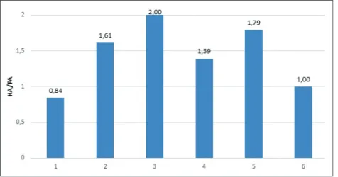
The type of humus content allows to evaluate the degree of organic matter stabilization with special reference to environ- mental conditions. The fulvate type (HA/FA is <0,5) is charac- terized by the predominance of fulvic acids in the soil and the migration of organic-mineral complexes along the profile. The humate-fulvate type is also characterized by the predominance of fulvic acids (the ratio of HA/FA is 0.5-1), in soils with this type of humus content, the migration of substances to a greater extent occurs than its accumulation. The fulvate-humate type is characterized by the predominance of humic acids (the ratio HA/FA is 1-2), accumulation and fixation of organic-mineral complexes in the profile and its insignificant migration take place. The humate type is characterized by a high predomi- nance of humic acids (HA/FA > 2) there is accumulation and fixation of organic-mineral complexes in the profile (orlov 1985, KimBle & follett 2001).
The type of humus content was determined in five samples from five profiles from three islands. Umbric Cryosol (Fluvic, Arenic, Reductaquic) are characterized by the humate-fulvate type. The migration of matter along the soil profile and fixing on the border with permafrost occurs, also organic-mineral compounds through groundwater release into the river basin.
Umbric Cryosol (Loamic, Reductaquic) refer to a fulvate-hu- mate type, humic acids predominate over fulvic acids, accu- mulation of organic-mineral compounds occurs in soil profiles. Cryosol (Oxyaquic, Loamic, Reductaquic) belong to the fulvate-humate type. The formation of organic-mineral
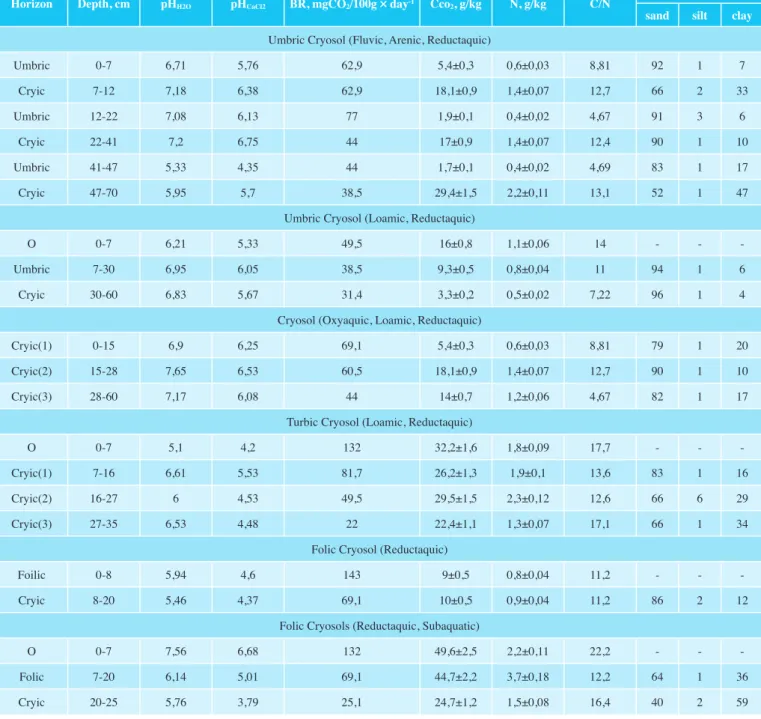
Horizon Depth, cm pHH2O pHCaCl2 BR, mgCO2/100g day-1 Cco2, g/kg N, g/kg C/N Particle-size classes sand silt clay Umbric Cryosol (Fluvic, Arenic, Reductaquic)
Umbric 0-7 6,71 5,76 62,9 5,4±0,3 0,6±0,03 8,81 92 1 7
Cryic 7-12 7,18 6,38 62,9 18,1±0,9 1,4±0,07 12,7 66 2 33
Umbric 12-22 7,08 6,13 77 1,9±0,1 0,4±0,02 4,67 91 3 6
Cryic 22-41 7,2 6,75 44 17±0,9 1,4±0,07 12,4 90 1 10
Umbric 41-47 5,33 4,35 44 1,7±0,1 0,4±0,02 4,69 83 1 17
Cryic 47-70 5,95 5,7 38,5 29,4±1,5 2,2±0,11 13,1 52 1 47
Umbric Cryosol (Loamic, Reductaquic)
О 0-7 6,21 5,33 49,5 16±0,8 1,1±0,06 14 - - -
Umbric 7-30 6,95 6,05 38,5 9,3±0,5 0,8±0,04 11 94 1 6
Cryic 30-60 6,83 5,67 31,4 3,3±0,2 0,5±0,02 7,22 96 1 4
Cryosol (Oxyaquic, Loamic, Reductaquic)
Cryic(1) 0-15 6,9 6,25 69,1 5,4±0,3 0,6±0,03 8,81 79 1 20
Cryic(2) 15-28 7,65 6,53 60,5 18,1±0,9 1,4±0,07 12,7 90 1 10
Cryic(3) 28-60 7,17 6,08 44 14±0,7 1,2±0,06 4,67 82 1 17
Turbic Cryosol (Loamic, Reductaquic)
O 0-7 5,1 4,2 132 32,2±1,6 1,8±0,09 17,7 - - -
Cryic(1) 7-16 6,61 5,53 81,7 26,2±1,3 1,9±0,1 13,6 83 1 16
Cryic(2) 16-27 6 4,53 49,5 29,5±1,5 2,3±0,12 12,6 66 6 29
Cryic(3) 27-35 6,53 4,48 22 22,4±1,1 1,3±0,07 17,1 66 1 34
Folic Cryosol (Reductaquic)
Foilic 0-8 5,94 4,6 143 9±0,5 0,8±0,04 11,2 - - -
Cryic 8-20 5,46 4,37 69,1 10±0,5 0,9±0,04 11,2 86 2 12
Folic Cryosols (Reductaquic, Subaquatic)
O 0-7 7,56 6,68 132 49,6±2,5 2,2±0,11 22,2 - - -
Folic 7-20 6,14 5,01 69,1 44,7±2,2 3,7±0,18 12,2 64 1 36
Cryic 20-25 5,76 3,79 25,1 24,7±1,2 1,5±0,08 16,4 40 2 59
Tab. 3: Chemical characteristics of different types of soils from Lena River Delta. Where BR - soil basal respiration (mg CO2/100 g day-1), Cco2 – carbon content, g/kg with SD.
Tab. 3: Chemische Eigenschaften unterschiedlicher Bodentypen des Lena-Deltas: BR – basale Bodenatmung (mg CO2/100 g Tag-1); Cco2 – Kohlenstoffgehalt mit SD, g/kg.
complexes of ferrum and humus occurs and transfer along the soil profile. Turbic Cryosol (Loamic, Reductaquic), are char- acterized by the fulvate-humate type, there is the formation of organic-mineral complexes close to the permafrost, with the cryogenic mass exchange, the mineral and organic part of the soil is redistributed along the profile. Folic Cryosol (Reduc- taquic), the type of the humus content – humate-fulfate, the ratio HA/HA is 1. This indicates that fulvic acids predominate and the substances migrate along the profile. Folic Cryosols (Reductaquic, Subaquatic) refer to a humate-fulvate type, fulvic acids predominate, iron and humus complexes migrate along the profile and accumulate on the contact border with
permafrost. The soils of the Lena River Delta are charac- terized mainly by a fulvate-humate type of humus content (HA/FA is 1-2. This is due to the accumulation of humic acids in the soils and the formation of organic-mineral complexes of ferrum and humus, and also its low migration ability (Fig. 3).
According to the type of humus content, the soils of the delta are referred to the humate-fulvate and fulvate-humate types, which were also observed in former studies (zolotareva et al. 2009a, zolotareva et al. 2009b, DoBrovolsKy 2011, oKoneshniKova 2016, DesyatKin et al. 2011, tarGulian 1971, shishKin et al. 2001, Dymov et al. 2013, voDyantsKy 2008).
Soil organic carbon
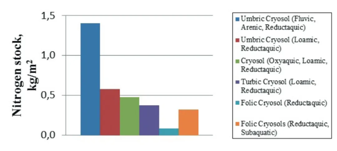
Soils of the Lena River Delta have a large storage of organic carbon in Umbric and Folic horizons. Accumulation of humus occurs in the upper layers of the soil and on the border with permafrost, due to humus transportation activity and the formation of geochemical barrier close to permafrost. Based on the obtained results, it is possible to reveal the dependence of the distribution and fixation of humus in the soil. Umbric Cryosol (Fluvic, Arenic, Reductaquic) are associated with stratification and low humus content along the profile, which indicates a low biological activity.
The stocks of organic carbon in the soils of the Lena River Delta were estimated. Thus, the soils formed in the zone of the seasonal flooding in the period of high water are char- acterized by the highest value of the organic matter, up to 17 kg/m2. With floodwaters, a large amount of organic matter enter the soil and, under conditions of low biological activity, are able to accumulate in the soil. In Umbric Cryosol (Loamic, Reductaquic) organic remains are – 5 kg/m2. Soils recently came out from the seasonal flooding regime have high stocks of accumulated organic material. Lower stocks of humus as the previous soils, 0.9 kg/m2 characterize Folic Cryosol (Reduc- taquic). For Folic Cryosols (Reductaquic, Subaquatic) stock is 4.5 kg/m2 . These soils are zonal in the delta, humus accumula- tion takes place mainly on the border with permafrost. Turbic Cryosol (Loamic, Reductaquic) and Folic Cryosol (Reduc- taquic) have 5.8 kg/m2. Many studies are devoted to carbon
stocks and organic carbon content in Arctic soils. The data we obtained now fully correlate to the data reported by others.
Soils are characterized by increase to 24 % organic carbon content and up to 29 kg/m2 of carbon stocks (zuBrzycKi et al.
2013).
As can be seen from the Fig. 4, the largest stocks of humus occurs in the soils related to flooded areas. Smaller stocks of humus characterize soils related to the post-lithogenic group, which due to a close occurrence of permafrost with buried organic remains within. Depending on the natural zone, the carbon stock will differ. Soils of the Samarskaya Luka National Park have been investigated by other researchers, it is a part of the forest-steppe zone, Cambisols, Chernozems, Phaeozems and Podzols develop here (aBaKumov et al.
2010). The humus reserve was estimated in the range from 13 to 41 kg/m2. According to the author‘s data, the humus stocks depend on the exposition of the slope, vegetation cover, and fine soil content. The greatest stocks in Chernozems were observed.
Analytical results permit the determination of carbon stocks within each horizon:
SOC = ρ Coc H 0.1 (1)
Where, SOC – soil organic carbon (kg/m2); ρ-horizon density;
Coc – organic carbon content (%); 0,1 – conversion factor; H – depth.
Fig. 3: Humus condition of soils (1 - Folic Cryosols (Reductaquic, Subaquatic); 2 - Umbric Cryosol (Loamic, Reductaquic); 3 - Umbric Cryosol (Fluvic, Arenic, Reduc- taquic); 4 - Cryosol (Oxyaquic, Loamic, Reductaquic);
5 - Turbic Cryosol (Loamic, Reductaquic); 6 - Folic Cryosol (Reductaquic).
Abb. 3: Humus-Bedingungen/Zustand der Böden (1 - Fo- lic Cryosols (Reductaquic, Subaquatic); 2 - Umbric Cryo- sol (Loamic, Reductaquic); 3 - C; 4 - Cryosol (Oxyaquic, Loamic, Reductaquic); 5 - Turbic Cryosol (Loamic, Re- ductaquic); 6 - Folic Cryosol (Reductaquic).
Fig. 4: Carbon stocks in different type of soils of Lena River Delta.
Fig. 4: Kohlenstoffgehalte verschiedener Bodentypen des Lena-Deltas.
We compared carbon stocks in various soils under the influ- ence of permafrost-affected soils. According to the data by Nesterova from the Bie-Chumyshskaya plain (the right bank of the Ob) and the Priobskoe plateau (the left bank of the Ob), the humus stocks in the forest-steppe averages 55 kg/m2 (nesterova et al. 2004). The maximum of humus stock refers to a depth of 0 to 50 cm, which is due to the root layer and not intensive biological activity, which is related to the freezing of the soil in winter and the drying in the summer. These data indicate that the maximum carbon content is for the upper soil horizons, where the root system of plants is located and the biological decomposition processes take place.
We compared our soils with the volcanic soils of Kamchatka, according to the data by Kiseleva et al. (2016). The soils are represented by Aluandic Andosols, Folic Fluvisols and Silandic Andosols. The humus stocks are estimated at 29 kg/m2 in Aluandic Andosols, 5.9 for Folic Fluvisols and 7.7 for Silandic Andosols. Such a distribution of quantities is asso- ciated with the vegetation cover of Kamchatka. These soils have similar estimates of carbon stocks with those obtained by us. This may be due to low biological activity in volcanic soils, as well as a high content of ash elements.
The carbon stocks of the Lena River Delta were compared with the soils of Central Yakutia; the reserve of humus here in the virgin lands reaches 20 kg/m2 on Fluvisols, they are included in the group with a very high humus stock values (0-20 cm) (oKoneshniKova 2004). Folic Fluvisols are char- acterized by stocks of 12 kg/m2, and it was noted that during agricultural work the humus reserve decreases to 9 kg/m2. Annually flooded permafrost soils of Yakutia have a higher indicator of humus content. These results confirm that annual flood processes contribute to an increase in the carbon content in the soil. These soils have favorable physic and chemical parameters (pH, texture class, etc.), contributing to the deposi- tion of carbon in the soil.
Thus, according to the dynamics of the distribution of humus content among various natural zones, maximum values are observed in the zone of steppes and forest-steppe. Alluvial soils also have a high humus reserve due to the high amount of biogenic matter from the river alluvium. In general, the soils of the permafrost zone are characterized by humus stocks of 10-40 kg/m2.
Nitrogen stocks
The nitrogen stocks in the investigated soils were esti- mated (Fig. 5). The nitrogen content in the soil varies from 0.3 kg/m2 and up to 1.4 kg/m2 for Umbric Cryosol (Fluvic, Arenic, Reductaquic). In general, nitrogen reserves are similar to soils in the northern part of the circumpolar Urals from 0.45 to 2.4 kg/m2 (Dymov et al. 2013). The maximum values are observed in Umbric Cryosol (Fluvic, Arenic, Reductaquic), this is possibly associated with the more rich nitrogen compo- nents of plant litter. For Umbric Cryosol (Loamic, Reduc- taquic), which are characterized by a physico-chemical and morphological properties of a nitrogen reserve – 0.5 kg/m2. The floral composition here is similar to the composition on Umbric Cryosol (Fluvic, Arenic, Reductaquic), but in Umbric Cryosol (Loamic, Reductaquic) the prevalence of flowering plants is much lower and moss litter is formed, which in the soils of Umbric Cryosol (Fluvic, Arenic, Reductaquic) is prac- tically not formed due to the long process of fertility. Nitrogen reserves were also studied earlier in the soils of Samoilovsky Island (zuBrzycKi et al. 2013), the reserve was determined in the amount from 0.41 kg/m2 to 1.94 kg/m2. The results are very similar to those obtained, with one exception, the maximum values for Zubrzycki were obtained in the region of Holocene sediments, the second terrace, and not the first one being flooded. He explains this definition by the fact that a large amount of nitrogen is stored in permafrost rocks of the Lena River Delta.
Nitrogen stocks in the soils of the Northern Caspian (Volgo- grad Region, Russia) (KulaKova 2014) were studied. Areas of work have become a steppe ecosystem and forest. For the steppe ecosystem, an average of 1.112 kg/m2 is typical, for the forest ecosystem the average nitrogen reserve is 1.245 kg/m2. This is due to the fact that in forest ecosystems consisting of broad-leaved trees the plant litter is more rich in nitrogen than the grass and shrub flora in the steppe ecosystem.
Thus, according to the dynamics of nitrogen stocks in various natural zones, a maximum is observed in zones of perma- frost-affected soils. According to Dymov et al. (2013), up to 2.4 kg/m2 is stored in the soils of the circumpolar Urals.
High levels of nitrogen reserves largely depend on the floristic composition of the ecosystem and microbiological activities.
Analytical results permit the determination of nitrogen stocks within each horizon:
Fig. 5: Nitrogen stocks in different type of soils of Lena River Delta.
Abb. 5: Stickstoffgehalte in verschie- denen Bodentypen des Lena-Deltas.
N = ρ Nc H 0.1 (2)
Where, N - nitrogen stocks (kg/m2); ρ-horizon density; Nc- nitrogen content (%); 0,1 - conversion factor; H - depth.
Texture class of soils
The investigated soils are divided into four categories: sand, loamy sand, sandy loam, silt loam. As can be seen from the figure, most of the treated samples belong to the category of sand. This suggests that a large amount of alluvium is depos- ited in the delta. This fact indicates a high flow rate, as a result of which large particles settle. The increase of silt fraction is due to the fact that, with a small change in the river bed and the flow rate, smaller particles settle, and the silt particles fall out in a very small amount. Sand is represented in soils devel- oping in areas of floodplain meadows. On the third terrace, the soil develops with loamy sand, sandy loam and silty loam, which is associated mostly with the formation of the parent material.
Thus, the soils of the Lena River Delta are characterized by a clear variety of conditions. Floodplain meadows are repre- sented by stratified soil with various hydrophysical proper- ties. Here, the horizons rotate with the texture class of loamy sand and silty loam, and the amount of soil organic carbon in organic horizon is different from each other.
High aeration and light texture class prevent the formation of thermokarst lakes, as a result of which well-drained positions are formed on which the formation of soils takes place. This is primarily due to the fact that the islands were formed in a short time, because the settling of large sand particles occurs in a fast flow of water, and clay and silt particles – at a low flow rate.
Elemental Composition of humic acids
In general terms, elemental composition of the HAs is compa- rable with previously reported data for soils of polar envi-
ronments (aBaKumov 2017, luPachev et al 2017, eJyrque
& aBaKumov 2016, aBaKumov et al. 2015). Characteristic features of HAs formed in cold conditions, and especially in soils exposed to permafrost, are a relatively high H content and a reduced O content compared to boreal and sub boreal soils (luPachev et al. 2017). According to the obtained data (Table 4), the Turbic Cryosol (Loamic, Reductaquic) sample is characterized by active cryogenic processes (thermal cracking, ice segregation, cryogenic mass transfer). That is reflected in the elemental composition, the high index of H and the low value of O. Whereas the soils are formed in conditions of weak cryogenic processes characterized by higher N and O. Such a distribution may indicate active humus formation in condition of low degree of cryogenic processes in soils.
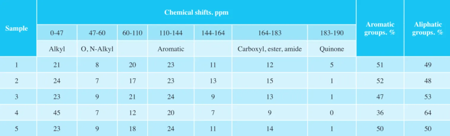
Characterisation of humic acids by 13C-NMR spectroscopy The composition of HAs is one of the most important prop- erties, which is used as an indicator of the humification, of oxidation of humic acids and for an indirect assessment of the degree of its condensation (loDyGin & BeznosiKov 2010, loDyGin et al. 2014). The greatest number of signals is obtained in the range of 110-144 ppm, which refer to the aromatic group that is characterized by high content of unsub- stituted or alkyl-substituted aromatic carbon atoms. The pres- ence of a high content of aromatic group for arctic soils is uncharacteristic that is associated with a low level of humifi- cation and accumulation of organic substances in the soil. An accumulation of alkyl groups occurs, its signals are located in the range 0-47 ppm, that is typical for the Turbic Cryosol (Loamic, Reductaquic) sample (Fig. 6 D). Most likely it is due to the low permafrost depth in the soil and the high degree of the cryogenic processes, accompanied by solifluction, and thixotropy. The other soils are characterized by the predom- inance of aromatic compounds including -ОН, -NH2, and -OCH3 (144-164 ppm) groups, structural blocks of lignin and for oxygen compensated atoms of aromatic rings (syringyl and guaiacyl propane units) (147-149 ppm). Atoms of carboxyl fragments, polypeptides, and carbonyl-amides (164-183 ppm) and atoms of quinone fragments and the carbonyl groups of
Sample N, % C, % H, % О, % С/N H/C O/C
Cryosol
(Oxyaquic, Loamic, Reductaquic) 3,43 50,13 4,85 36,60 14,64 0,10 0,73
Folic Cryosol
(Reductaquic) 3,52 42,83 4,55 44,11 12,17 0,11 1,03
Umbric Cryosol
(Loamic, Reductaquic) 3,13 42,94 4,88 44,06 13,72 0,11 1,03
Turbic Cryosol
(Loamic, Reductaquic) 2,95 53,39 6,14 32,53 18,13 0,12 0,61
Cryosol
(Oxyaquic, Loamic, Reductaquic) 3,44 44,59 4,84 42,15 12,98 0,11 0,95
Tab. 4: Elemental composition (%) and atomic ratios in HAs. 1- Cryosol (Oxyaquic, Loamic, Reductaquic); 2- Folic Cryosol (Reductaquic); 3- Umbric Cryosol (Loamic, Reductaquic); 4- Turbic Cryosol (Loamic, Reductaquic); 5- Cryosol (Oxyaquic, Loamic, Reductaquic). Samples were taken from the upper horizons of the soil.
Tab. 4: Elementzusammensetzung (%) und ihre atomaren Verhältnisse in den Huminsäuren.