Field Symposium of the INQUA PeriBaltic Working Group
"From Weichselian Ice-Sheet Dynamics to Holocene Land Use Development in Western Pomerania and Mecklenburg"
- Abstract Volume -
Scientific Technical Report STR19/01
Group "From Weichselian Ice-Sheet Dynamics to Holocene Land Use Development in Western Pomerania and Mecklenburg". Abstract Volume. Scientific Technical Report STR 19/01, Potsdam:
GFZ German Research Centre for Geosciences.
DOI: https://doi.org/10.2312/GFZ.b103-19012
Imprint
Telegrafenberg D-14473 Potsdam Published in Potsdam, Germany
August 2019 ISSN 2190-7110 DOI: https://doi.org/10.2312/GFZ.b103-19012 URN: urn:nbn:de:kobv:b103-19012 This work is published in the GFZ series Scientific Technical Report (STR) and electronically available at GFZ website www.gfz-potsdam.de
This work is licensed under a Creative Commons Attribution 4.0 International License.
(CC BY 4.0) https://creativecommons.org/licenses/by/4.0/
Field Symposium of the INQUA PeriBaltic Working Group
"From Weichselian Ice-Sheet Dynamics to Holocene Land Use Development in Western Pomerania and Mecklenburg"
Abstract Volume
Scientific Technical Report STR19/01
Field Symposium of the INQUA PeriBaltic Working Group
“FROM WEICHSELIAN ICE-SHEET DYNAMICS TO HOLOCENE LAND USE DEVELOPMENT IN WESTERN POMERANIA AND MECKLENBURG”
Abstract Volume
Edited by
Andreas Börner, Heiko Hüneke, Sebastian Lorenz
Greifswald University, Institute for Geography and Geology
Helmholtz Centre Potsdam - German Research Centre for Geosciences, Potsdam State Authority for Environment Nature protection and Geology of
Mecklenburg – Western Pomerania, Geological Survey, Güstrow
Table of Contents
Table of contents 2 Page
Welcome note and introduction 3
Abstract list in alphabetical order 4-7
Abstracts in alphabetical order 8-133
Acknowledgements 134
Notes 135
Welcome note and introduction to the
Field Symposium of the INQUA PeriBaltic Working Group 2019
“FROM WEICHSELIAN ICE-SHEET DYNAMICS TO HOLOCENE LAND USE DEVELOPMENT IN WESTERN POMERANIA AND MECKLENBURG”
We cordially welcome the Quaternary Peribaltic community and guests to the 2019 Field Symposium of the INQUA PeriBaltic Working Group at Greifswald University. We gather here to present new research findings and share them with the Peribaltic scientific community. In addition, the symposium also provides the opportunity to address challenges and directions of our future research and to discuss innovative approaches and methodologies to our research work. Results will be presented during a full day presentation session followed by the traditional 4-day field trip to present current research sites and findings from ongoing investigations on Quaternary themes and lake monitoring activities.
8th September 2019: Oral and poster presentation
9. –12th September 2019: Field trip from Rügen Island to the Mecklenburg Lake District
• Kinematics of the Jasmund Glacitectonic Complex on Rügen island (landform and structural analysis)
• Weichselian glaciation on Rügen (luminescence dating, sediment-facies analysis, micromorphology, till microfabrics, seismites)
• The River Tollense valley - From subglacial channel to Bronze age battle field (Quaternary and Holocene valley and river development, archaeology) and the Nature Discovery Center Müritzeum
• From Krakow am See to Lake Tiefer See (postglacial lake, river and soil development, limnic deposition, lake monitoring)
We thank all participants for their inspiring contributions and results summarized in this Abstract Volume and wish all of us fruitful discussions, fresh ideas, new collaborations, and an enjoyable time in the field among friends in Mecklenburg-Western Pomerania.
On behalf of the entire organization team
Andreas Börner, Heiko Hüneke, Achim Brauer and Sebastian Lorenz
A bstract list in alphabetical order
Page abstract list in alphabetical order
9
Belzyt, Szymon*; Pisarska-Jamroży; Małgorzata; Bitinas, Albertas; Jusienė, Asta and Woronko, Barbara
Differences between periglacially-, seismicity-related and glacitectonically-trigerred soft- sediment deformation structures, case study from Slinkis site (Central Lithuania)
Oral
11 Bitinas, Albertas
The last Scandinavian Ice Sheet: areal vs. frontal paradigm of deglaciation Oral 13
Błaszkiewicz, Mirosław*; Tyszkowski, Sebastian; Brauer, Achim; Bonk, Alicja; Müller, Daniela;
Schwab, Markus and Słowiński, Michał
Mass movement deposits in the sediments of Lake Gościąż
Poster
15
Börner, Andreas*; Müller-Navarra, Katharina; Rother, Henrik and Schütze, Karsten
The exploration of heavy minerals and Rare Earth Elements (REE) in marine sand deposits on the SW Baltic Sea floor – Scientific background and progress report of the SEEsand project
Poster
17
Böse, Margot*; Hardt, Jakob and Lüthgens, Christopher
The southwestern sector of the Weichselian Scandinavian Ice Sheet: Facts and knowledge gaps
Oral
19
Borodulina, Galina*; Tokarev, Igor; Voroniuk, Grigory and Subetto, Dmitry
The isotopic composition of groundwater in the Baltic–White Sea region as a reflection of geographical and climatic evolution in the Late Pleistocene-Holocene
Poster
21
Czubla, Piotr* and Sokołowski, Robert J.
Did the Baltic Ice Stream exist during the Late Saalian? New data from the northern Wielkopolska and Eastern Pomerania regions, Poland
Oral
23
Druzhinina, Olga*; Stančikaitė, Miglė; Kublitskiy, Yury; Nazarova, Larisa; Syrykh, Ljudmila;
Gedminienė, Laura; Vaikutienė, Giedrė and Subetto, Dmitry
The Late Pleistocene-Early Holocene palaeoenvironmental evolution in the SE Baltic region: a multi-proxy palaeolimnological approach based on the Kamyshovoe Lake record
Oral
25
Dzieduszyńska, Danuta A.*; Petera-Zganiacz, Joanna and Forysiak, Jacek
Properties of the aeolian covers in extraglacial part of the last Vistulian ice sheet limit (Central Poland)
Oral
28 Forysiak, Jacek*; Majecka, Aleksandra; Marks, Leszek and Okupny, Daniel
Relic pingo at Józefów in central Poland Oral
30 Frydrych, Małgorzata*; Rdzany, Zbigniew and Petera-Zganiacz, Joanna
The problem of analysing grain size distribution in fluvioglacial coarse-grained sediments Poster 32
Golyeva, Alexandra* and Golev, Aleksandr
Microbiomorphic analysis: possibilities, limits and information capacity for landscape reconstruction
Oral
34 Górska, Martyna Eliza
Hybrid event beds from the Tylmanowa site (Polish Outer Carpathians) Poster 35 Grigienė, Alma* and Jusienė, Asta
Merkinė (Eemian) deposits at the Kurkliai outcrop Poster
37
Hang, Tiit*; Gurbich, Viktor; Subetto, Dmitry; Strakhovenko, Vera; Potakhin, Maksim;
Belkina, Nataliya and Zobkov, Mikhail
Glacial varves of Onega Ice Lake, Russian Karelia
Poster
39
Kindermann, Regina and Rother, Henrik*
Late Pleistocene deglaciation and Scandinavian Ice Sheet dynamics in NE-Germany: new results from surface exposure dating in Mecklenburg-Vorpommern
Poster
Page abstract list in alphabetical order
41
Kittel, Piotr*; Mazurkevich, Andrey; Danger, Maxime; Dolbunova, Ekaterina; Gauthier, Emilie;
Krąpiec, Marek; Kurzawska, Aldona; Maigrot, Yolaine; Mroczkowska, Agnieszka;
Okupny, Daniel; Płóciennik, Mateusz; Pawłowski, Dominik 0.; Rzodkiewicz, Monika;
Słowiński, Michał; Szmańda, Jacek and Wieckowska-Lüth, Magda
Earth, water, air, fire – human-environment relationships in the multi-proxy palaeoecological study at Serteya in Western Russia
Poster
45 Korsakova, Olga*; Nikolaeva, Svetlana; Kolka, Vasily; Tolstobrov, Dmitry and Tolstobrova, Alena
Imandra Lake depression in the Late Glacial and Holocene (Kola Peninsula, NW Russia) Poster 48 Korsakova, Olga* and Zaretskaya, Nataliya
Mid Weichselian paleoenvironments in the N-E Fennoscandian Shield (N-W Russia) Poster
51
Kublitskiy, Yuriy*; Subetto, Dmitriy; Vlasov, Boris; Novik, Alexey; Leontev, Piotr; Grekov, Ivan;
Syrykh, Liudmila; Sokolova, Natalia; Brylkin, Vyacheslav; Panov, Ivan; Kittel, Piotr;
Mroczkowska, Agnieszka; Kuznetsov, Denis; Mazurkevich, Andrey; Dolbunova, Ekaterina and Kotrys, Bartosz
Palaeolimnological approach for the reconstruction of environmental changes in the Serteya region (Western Russia) – preliminary results
Poster
53
Kust, Pavel*; Makeev, Alexander and Lesovaia, Sofia
Bipartite Sediments within the Moscow (Saalian) Glacial Limits of the Russian Plain:
Mineralogy, Micromorphology and Soil Formation Framework
Oral
55 Kuznetsov, Denis
Organic sedimentation in Lake Ladoga during the Holocene Poster
56
Leszczyńska, Karolina*; Stattegger, Karl; Szczuciński, Witek; Moskalewicz, Damian and Słowik, Marcin
Catastrophic coastal flooding events along the southern Baltic Sea coast during the Late Holocene
Poster
58
Ludikova, Anna
Diatom-inferred Lake Ladoga preglacial paleoenvironments and its possible connection to the Baltic
Poster
60
Majecka, Aleksandra*; Forysiak, Jacek; Marks, Leszek; Tołoczko-Pasek, Anna;
Stachowicz-Rybka, Renata and Korzeń, Katarzyna
New botanical records from the fossil closed depressions in the central Poland
Oral
62
Makeev, Alexander*; Rusakov, Alexey; Kurbanova, Fatima; Khokhlova, Olga; Kust, Pavel;
Puzanova, Tatiana; Lebedeva, Marina and Denisova, Elizaveta
Landscape response to the Late Holocene climatic cycles at the southern frontier of the forest belt of the Russian Plain
Poster
65 Mleczak, Mateusz
Sedimentological record of glaciofluvial flood (distal part of Gwda sandur, W Poland) Poster 66
Moskalewicz, Damian*; Szczuciński,Witold and Mroczek, Przemysław
Sedimentary record of storm surge deposits along SE Baltic coast formed under indundation and overwash regimes
Oral
68 Nartišs, Māris
New insights on ice dynamics from analysis of terrain of Latvia Oral
70
Nitychoruk, Jerzy*; Welc, Fabian; Bińka, Krzysztof; Obremska,Milena; Rogóż, Anna; Zalat, Abdelfattah; Marks, Leszek; Chodyka, Marta; Grudniewski, Tomasz Marek and Zbucki,Łukasz Climate change, environmental history and Human impact during the Late Holocene inferred from palynological, diatomological and geochemical data from selected lakes in the north- eastern Poland
Poster
Page abstract list in alphabetical order 71
Papiernik, Piotr; Jankowski, Michał and Forysiak, Jacek*
Impact of pre-historic settlement and natural processes on development of the land surface.
The Redecz Krukowy archaeological site (Kuyavia, Central Poland)
Poster
74
Petera-Zganiacz, Joanna*; Dzieduszyńska, Danuta A.; Forysiak, Jacek; Twardy, Juliusz;
Milecka, Krystyna and Czerwiński, Bartłomiej
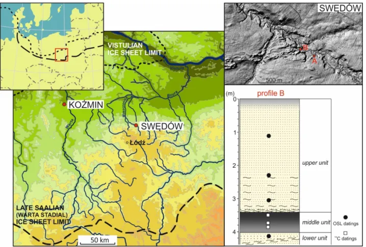
The Late Vistulian record in deposits of the Moszczenica River valley at the Swędów site (Central Poland)
Poster
77
Piotrowski, Andrzej* and Brose, Fritz
Geological effects of a catastrophical flood of salt water - inundation - tsunami in Kolobrzeg in in the light of chronicler’s records, N Poland
Poster
78 Piotrowski, Andrzej; Stępień, Grzegorz and Zygmunt, Marek*
Bolder stone Tryglaw in Tychowo, Pomeranian North Poland Poster
79 Piotrowski, Andrzej; Stępień, Grzegorz and Zygmunt, Marek*
Stronghold Santok in the light of UAS Photogrammetry Poster
81
Pisarska-Jamroży, Małgorzata*; Woronko, Barbara; Bujak, Łukasz; Bitinas, Albertas;
Belzyt, Szymon and Mleczak, Mateusz
Load casts and pseudonodules as indicative soft-sediment deformation structures of glaciolimnic kames
Poster
82
Pogosyan, Lilit*; Kulikova, Tatiana; Sedov, Sergey; Pi Puig, Teresa; Sheinkman, Vladimir;
Yurtaev, Andrey and Krasilnikov, Pavel
Clay illuviation in loamy soils of north-western Eurasia - evidence of early Holocene warm stage?
Oral
84
Ponomarenko, Ekaterina
Holocene paleoenvironment of the Central Baltic Sea based on benthic foraminifera record from the Gotland Basin
Poster
86 Rdzany, Zbigniew* and Frydrych, Małgorzata
Glacial outburst floods in the old glacial landscape zone of the Polish Lowlands Poster 89
Rosentau, Alar*; Nirgi, Triine; Hang, Tiit; Jonuks, Tõnno; Jõeleht, Argo; Kriiska, Aivad;
Risberg, Jan; Suuroja, Sten and Tõnisson, Hannes
Holocene relative shore level changes in the Gulf of Riga – new data from the Pärnu Bay area
Oral
91
Rusakov, Alexey* and Fedorova, Maria
Buried soils under stone mounds in the Eastern part of the Leningrad region, Russia (the monument Zabel'e ): Genesis and paleoenvironmental inferences
Oral
94 Sarala, Pertti*; Kaislo, Linnea; Korkala, Heta-Maria and Raatikainen, Markus
LiDAR-based mapping of the variable subglacial geomorphology in the central part of SIS Oral
95
Satkunas, Jonas*; Slavinskiene, Gintare; Slavinskas, Aurimas; Taminskas, Julius and Zanevskij, Zdislav
Springs in Quaternary landscape – source of information on climate change and anthropopression
Poster
96 Semenova, Ljudmila* and Zakharov, Igor
The Boundary оf the First Late Pleistocene Glaciation оf The European Russia Poster
98
Shatalova, Angelina E.*; Kublitsky, Yurii A.; Subetto, Dmitry A.; Rosentau, Alar;
Ludikova, Anna V.; Sokolova, Natalia V. and Syrykh, Ljudmila S.
Study of the Holocene sea-level changes of the Baltic Sea on the territory of the Karelian Isthmus
Poster
Page abstract list in alphabetical order 100 Shelekhova, Tatiana
Karelia’s ice-divide accumulation uplands Poster
102
Shvarev, Sergey*; Nikonov, Andrey; Subetto, Dmitry; Zaretskaya, Nataliya and Romanov, Anton Seismites in the pre- and postglacial sediments of the Karelian Isthmus
(Eastern Fennoscandia)
Poster
105
Sokołowski, Robert J.*; Hrynowiecka, Anna; Woronko, Barbara and Moska, Piotr
Osłonino Cliff section, northern Poland - an insight into palaeoclimate conditions during the end of Marine Isotope Stage
Poster
107
Steffen, Holger*; Steffen, Rebekka and Tarasov, Lev
Modelling of glacially-induced stress changes in Latvia, Lithuania and the Kaliningrad District of Russia
Poster
108 Steffen, Holger* and Steffen, Rebekka
On models of glacially induced fault reactivation and how to constrain them Oral
109
Subetto, Dmitry*; Belkina, Nataliya; Rybalko, Alexander; Strakhovenko, Vera;
Zobkov, Mikhail; Potakhin, Maksim; Borodulina, Galina; Gurbich, Victor; Kublitskii, Yurii;
Kiskina, Aleksandra; Ovdina, Ekaterina; Fedorov, Grigory; Hang, Tiit; Korost, Svetlana;
Belayev, Pavel; Belov, Mikhail and Barymova, Aleksandra
Sedimentary environments in Lake Onega: from Late Glacial to modern conditions
Oral
111
Subetto, Dmitry*; Nikonov, Andrey; Shvarev, Sergey; Zaretskaya, Natalya; Napreenko- Dorokhova, Tatyana; Kublitsky, Yurii and Druzhinina, Olga
Role of catastrophic events in the forming of hydrographic networks in the eastern part of the Baltic Sea
Poster
113 Sukhacheva, Elena and Timofeeva, Yulya*
Degradation of soil covers the mining territory of the Leningrad region Poster 115 Taminskas, Julius; Mikulenas, Vidas; Satkunas, Jonas* and Minkevicius, Vytautas
Trends of development of karstic landscape due to climate factors - case of Lithuania Poster 117
Tsvirko, Dmitry
Reconstruction of environment and stages of human activity in the Bug river valley in the Holocene in Belarus
Poster
120 Tylmann, Karol*; Moskalewicz, Damian; Woźniak, Piotr Paweł and Moska, Piotr
Sedimentary record of fluvial processes during MIS in central-western Poland Poster 121
Tylmann, Karol*; Rinterknecht, Vincent; Börner, Andreas and Piotrowski, Jan A.
Bayesian age modelling of the last deglaciation in the southern sector of the Scandinavian Ice Sheet
Oral
123
Vaikutienė, Giedrė*; Bitinas, Albertas; Damušytė, Aldona and Grigienė, Alma
Geological investigations of postglacial environment in the Southeastern Baltic Sea area (Lithuanian zone)
Oral
124
Woźniak, Piotr Paweł*; Belzyt, Szymon; Pisarska-Jamroży, Małgorzata; Nartišs, Māris;
Lamsters, Kristaps; Woronko, Barbara and Bitinas, Albertas
Multiple deformed layers in Weichselian lacustrine sediments at Baltmuiža, western Latvia
Poster
126
Woźniak, Piotr Paweł* and Elwirski, Łukasz
The evolution of lithic clast morphology in a debris flow – evidences from subaquatic debrites (Rzucewo, northern Poland)
Poster
128 Zaretskaya, Nataliya*; Panin, Andrei; Simakova, Aleksandra and Kurbanov, Redzhep
Late Glacial in the European North-East: new data and pattern Poster 131 Zaretskaya, Nataliya*; Shvarev, Sergey; Korsakova, Olga and Grigoriev, Vasiliy
Palaeoseismic traces in the Late Pleistocene deposits of Southern Kola peninsula Oral
Abstracts in alphabetical order
Differences between periglacially-, seismicity-related and glacitectonically-trigerred soft- sediment deformation structures, case study from Slinkis site (Central Lithuania) Belzyt, Szymon1*, Pisarska-Jamroży, Małgorzata1, Bitinas, Albertas2, Jusienė, Asta3
and Woronko, Barbara4
1 Institute of Geology, Adam Mickiewicz University, B. Krygowskiego 12, 61-680 Poznań, Poland
2 Nature Research Centre, Akademijos 2, LT-08412 Vilnius, Lithuania
3 Lithuanian Geological Survey, S. Konarskio 35, Vilnius LT-03123, Lithuania
4 Warsaw University, Faculty of Geology, Żwirki i Wigury 93, 02-089 Warsaw, Poland
* E-mail corresponding author: szymon.belzyt@amu.edu.pl
Soft-sediment deformation structures (SSDS), frequently occurring in Pleistocene unconsolidated clastic sediments in the Southern Peribalticum area, may originate from various deforming mechanisms, i.a. gravity-driven processes, glacitectonics, cryoturbations, seismicity- related liquefaction or bioturbations. Extraordinary variation of plastic and brittle deformations has been described from the 5 m-high and 6.5 m-wide Slinkis site in the central Lithuania. The study site, located in the Dubysa river valley (3 km from its confluence with Nemunas river), is assigned to the hummocky morainic Nevėžis Plain, which was deposited and afterwards deformed during the end of the Last Glaciation (Upper Weichselian) and the Holocene.
The sedimentary succession was divided into two sedimentary units. The lower one consists of 2.3 m thick planar- and cross-stratified sands with silt admixtures (lithofacies Sp, Sl, St and Sr), while the upper one consists of up to 0.64 m thick cross-laminated, massive and deformed more fine-grained deposits (silt, silty sand, sandy silt; sand; lithofacies Fr, Fw, FSr, Sr, Sp, Fm, FSd and Fd).
The sediments in the lower unit represents compound bar, point bar and floodplain deposits of cold meandering river system (Pisarska-Jamroży et al., 2019).
Three groups of deformation structures are observed within the whole succession in Slinkis.
First of them are cryostructures represented by syngenetic/epigenetic ice-wedge casts, cutting the lower sedimentary unit. Wedges are relatively narrow (max. 10 cm) and widen in the uppermost parts. The second group are seismites represented by two layers with liquefaction-induced SSDS, interbedded with undeformed sediments. The SSDS, abundant along the whole lateral extent of the outcrop, contain water/sediment-escape pillars/channels, clastic diapirs, flame structures, pseudonodules and load casts accompanied by downwards and upwards injection structures. The shape and internal structure of load casts and injection structures as well as their relation to the host sediments clearly indicate the liquefaction of water-saturated sediments. Glacial isostatic earthquakes or glacial earthquakes are proposed as primary deformation trigger mechanisms. The third group of deformations are glacitectonic deformations represended by low angle dip-slip reverse faults occurred in both lower and upper units. They often cut load casts, water/sediment- escape structures as well as ice-wedge casts. An orientation and geometry of faults suggest its development in thrust regime, interpreted to be induced by compressive shortening during Last Glacial ice sheet advance from NNE-ENE direction.
Co-existence of diverse deformation structures led to the conclusion that the fluvial sequence in Slinkis site were succesively exposed on periglacial conditions, affected by seismicity-induced liquefaction and glacitectonic processes during the Late Pleistocene.
Acknowledgements. The study has been financially supported by a grant for the GREBAL project (No. 2015/19/B/ST10/00661) from the National Science Centre Poland.
References
Pisarska-Jamroży, M., Belzyt, S., Bitinas, A., Jusienė, A., Woronko, B., 2019. Seismic shocks, periglacial conditions and glacitectonics as causes of the deformation of a Pleistocene meandering river succession in central Lithuania, Baltica (in press).
The last Scandinavian Ice Sheet: areal vs. frontal paradigm of deglaciation Bitinas, Albertas1,2
1 Nature Research Centre, Akademijos 2, 08412 Vilnius, Lithuania
2 Marine Research Institute, Klaipėda University, Universiteto ave. 17, 92294 Klaipėda, Lithuania
* E-mail: albertas.bitinas@gamtc.lt
A relatively harmonious system of presumptions, hypothesis and models explaining the dynamics, morphogenesis and deglaciation of the last glacial advance (i.e. related with MIS 2) of the Scandinavian Ice Sheet (SIS) was developed in the second half of the XXth century in the entire peri- Baltic area (Raukas et al., 1995; and many others). The mentioned system of standpoints could be named – according to terminology and approaches of T. Kuhn (2003) – as a paradigm, i.e. as a glaciodynamics-deglaciation paradigm. This paradigm, influenced by ideas of P. Woldstedt (1931), predicts that the last deglaciation of SIS has a pulsating nature: the colder periods, when the ice sheet advanced (i.e. cryostadials and cryophasials; in publications usually named as stages and phases) periodically were changed by warmer periods (i.e. thermostadials and thermophasials) when the ice margin retreated (in the ice-free territories the organic rich sediments began to accumulate). Thus, stratigraphic subdivision of sediments, as well as palaeogeographic reconstructions of the last glacial advance, were based on the climatostratigraphic criterion. This standpoint was very deeply developed in the Eastern Baltic region. For example, the detailed descriptions of above mentioned climatostratigraphic units (cryo- and thermostadials, cryo- and thermophasials) were included into the Lithuania Stratigraphic Guide (Grigelis et al., 2002).
Moreover, the Guide guide requires that each stratigraphic unit should have a real stratotype (typical section) based on the data of corresponding investigations (palaeobotanic, geochronological, etc.). Others postulates of this paradigm, maybe the most important ones, are follows: 1) the frontal retreat of the ice margin prevailed during the last SIS deglaciation; 2) the ice margin pulsations (cryostadials, cryophasials) were synchronous according to entire perimeter on the ice sheet. As a result, a large amount of papers explaining different peculiarities of the last SIS deglaciation was published on the basis of this paradigm.
The problem of existing glaciodynamics-deglaciation paradigm is that the thermostadial or thermophasial status of all the previously famous geological sections (so-called stratotypes) with organic sediments (for example, sections of Ūla, Raunis, Antaviliai, Odra Bank) have not been confirmed after the more detailed investigations carried out during the last few decades. It was found that: 1) real age of the dated sediments is younger/older as previously estimated; 2) the sediments are laying not in situ; 3) the organic sediments were re-deposited from older interglacial layers (Bitinas, 2011). The existing concept of deglaciation cannot logically and convincingly explain the formation of such forms of glacial relief as glaciolacustrine plateau-like hills or kame terraces on the distal slopes of marginal ridges.
Due to existing contradictions of the existing glaciodynamics-deglaciation paradigm the idea of a new paradigm was suggested and developed (Bitinas, 2011, 2012). The new paradigm contains a few postulates linked with deglaciation of the last SIS:
– fluctuations of the so-called cryo- and thermostadials or cryo- and thermophasials were absent;
– the so-called stadial or phasial recessional marginal moraine ridges are result of glacial surges where meltwater beneath the ice sheet played the exclusively significant role: a majority of these ridges (probably except the Salpausselkä moraines only) are asynchronous along the SIS margin.
– the areal deglaciation of the last SIS significantly prevails against the frontal one: the frontal ice retreat was more characteristic for the initial stage of deglaciation, whereas the areal ice melting prevailed during deglaciation of the biggest part of glaciated territory.
Moreover, the new paradigm could more reliably explain formation of above mentioned very specific forms of glacial relief as glaciolacustrine plateau-like hills or kame terraces on the distal slopes of marginal ridges: it could be imagined only between the lobes of active ice sheet and the blocks of dead ice (Bitinas et al., 2004, 2012). The results of cosmogenic dating of boulders as well as OSL data of surficial and inter-morainic sandy sediments collected in the eastern flank of SIS and published by different authors during the latest decades do not contradict with presented postulates of the new paradigm. Moreover, the oldest radiocarbon data of reindeer’s antlers in the Eastern Baltic region maintain about synchronous expansion of reindeers into the biggest part of deglaciated territory (Ukkonen et al., 2006) – it also indirectly confirms the concept of areal deglaciation.
Any new evidences confirming the existing glaciodynamics-deglaciation paradigm and the prevailing concept about the frontal pattern of ice margin retreat (deglaciation) have not been found during geological investigations carried out in the few last decades. Nevertheless, this paradigm is still alive and widely applied in a number of present-day scientific publications.
References
Bitinas, A., 2011. Last Glacial in the Eastern Baltic region. Klaipėda University Press, Klaipėda. (In Lithuanian)
Bitinas, A., 2012. New insights into the last deglaciation of the south-eastern flank of the Scandinavian Ice Sheet, Quaternary Science Review 44, 69–80,
https://doi.org/10.1016/j.quascirev.2011.01.019.
Bitinas, A., Karmazienė, D. and Jusienė, A., 2004. Glaciolacustrine kame terraces as an indicator of conditions of deglaciation in Lithuania. Sedimentary Geology 165, 285–294,
https://doi.org/10.1016/j.sedgeo.2003.11.012.
Ukkonen, P., Löugas, L., Zagorska, I., Lukševica, L., Lukševic, E., Daugnora L. and Jungner, H., 2006.
History of the reindeer (Rangifer tarandus) in the eastern Baltic region and its implications for the origin and immigration routes of the recent northern European wild reindeer populations. Boreas 35 (2), 222–230, https://doi.org/10.1111/j.1502-3885.2006.tb01152.x.
Grigelis, A., Kondratienė, O., Paškevičius, J., Jankauskas, T. and Satkūnas, J., 2002. Lithuanian Stratigraphic Guide. Geological Survey of Lithuania, Vilnius.
Kuhn, T.S., 2003. The Structure of Scientific Revolutions. Pradai, Vilnius. (In Lithuanian).
Raukas, A., Aboltinš, O. and Gaigalas, A., 1995. Current state and new trends in the Quaternary geology of the Baltic States. Proceedings of Estonian Academy of Sciences Geology 44 (1), 1–
14.
Woldstedt, P., 1931. Über Randlagen der letzten Vereisung in Ostdeutschland und Polen und über die Herausbildung des Netze-Warthe Urstromtales. Jahrbuch der Preussischen Geologischen Landesanstalt 52, 59–67.
Mass movement deposits in the sediments of Lake Gościąż
Błaszkiewicz, Mirosław1*, Tyszkowski, Sebastian1, Brauer, Achim2, Bonk, Alicja1, Müller, Daniela2, Schwab, Markus2 and Słowiński, Michał1
1 Polish Academy of Sciences, Institute of Geography and Spatial Organization, Department of Environmental Resources and Geohazards, Toruń, Poland.
2 GFZ – German Research Centre for Geosciences, Section 5.2 Climate Dynamics and Landscape Evolution, Potsdam, Germany
* E-mail corresponding author: mirek@geopan.torun.pl
The subject of our research – Lake Gościąż, is located in the central part of the Płock Basin, which is a wide section of the Toruń - Eberswalde spillway. The lake fills the lowest part of a subglacial channel system, which formed during the last ice sheet transgression. The depth of subglacial channel incision, taking under consideration the depth of the lake and thickness of lake bottom sediments, reaches 50 metres. The slopes of subglacial channel under current water level reach up to 5 metres, and their angle up to 20 degrees. Along the southern slopes of subglacial channel with Lake Gościąż, there are numerous active spring niches and 3 well visible inactive fossil landslide niches.
Lake Gościąż is widely known in Earth Sciences because of annually laminated lake sediments, which occur in almost the entire sediment profile from the deepest part of the lake.
During previous research a massive sand layer was discovered in the Late Glacial part of the sediment record about 70 years after the onset of the Younger Dryas (Ralska-Jasiewiczowa et al., 1998). However, it was concluded that its accumulation was caused by mass movements, which did not result in a large erosion.
Current investigations showed that this sand layer is only a component of a large mass movement deposit with different sedimentological expression within the lake basin. Generally, in the southern part of the central deep of the lake, these mass movement sediments reach a thickness of about 2 metres. From the bottom sediments upwards, we can distinguish the following units:
1. Slump folds composed of deformed laminated gyttja and a massive sand layer included in these deformations which we interpret as subaquatic landslide.
2. Mixed gyttja with numerous sharp-edged intraclasts of brecciated laminated gyttja. The number of intraclasts decrease upwards. We interpret this unit as a debrite.
3. Mixed gyttja - as a result of mudflow.
4. 2 mm thick layer of silty gyttja – deposited from suspension.
In the northern part of the central deep of the lake only units no. 3 and 4 have been deposited. Geomorphological observations in the shore zone of the Lake Gościąż basin allow for connecting subaquatic movements with an inactive landslide located in central - southern part of the basin. This landslide has a very well developed main scarp. The presence of minor scarps in the upper part of the landslide tongue indicate a rotation type of the landslide. Similar type of landslide niches also occur in the south – eastern part of the subglacial channel. 14C dating of gyttja covered by 6 metres of colluvium indicate their time of origin to be similar to the central landslide.
The analysed landslides occurred around the transition from Allerød to the Younger Dryas, three hundred years after the assumed final melting of the buried dead ice in the subglacial channel.
At that time the lake basin has been already fully developed. This allows us to exclude dead ice melting processes as direct cause of the landslide activity. Possible causes of landslide activity include rapid changes of sediment moisture on the slopes of the lake basin as well as degradation
of permafrost. However, taking into account the fact that central landslides were formed during the cold period of the Younger Dryas, the degradation of permafrost is unlikely. Instead, we suspect permafrost aggradation and related concentration of ground water outflow. In this case, the mass movement activity could be attributed to high - pressure local ground water outflow. However, the level of age similarity between central and southern - eastern landslides can also show an earthquake activity, caused by glacioisostatic rebound.
A key argument to support this hypothesis is the occurrence of numerous tectonic dislocations in Cretaceous and Paleogene and Neogene sediments. In close proximity to the studied area also numerous salt structures as salt domes occur. Both the tectonic dislocations and salt structures were highly susceptible to all kinds of movements connected with glacioisostatic rebound after deglaciation.
In the early Holocene, within annually laminated lake sediments, only small, several – centimetres thin layers of deformed sediments can be observed. They occur in the form of small folds and load cast structures. These structures indicate minor subaquatic slopes instability.
This study is a contribution to scientific project financed by the National Science Centre, Poland - No. UMO-2015/19/B/ST10/03039.
References
Ralska-Jasiewiczowa, M., Goslar T., Madeyska, T. and Starkel, L. (eds.), 1998. Lake Gościąż, central Poland. A Monographic Study Part 1. Szafer Institute of Botany, Polish Academy of Sciences, Kraków, 340 pp.
The exploration of heavy minerals and Rare Earth Elements (REE) in marine sand deposits on the SW Baltic Sea floor – Scientific background and progress report of
the SEEsand project
Börner, Andreas1*, Müller-Navarra, Katharina2, Rother, Henrik 3 and Schütze, Karsten1
1 Landesamt für Umwelt, Naturschutz und Geologie Mecklenburg-Vorpommern, State Geological Survey, Goldberger Str. 12, 18273 Güstrow, Germany
2 Bundesanstalt für Wasserbau (BAW), Wedeler Landstr. 157, 22559 Hamburg, Germany
3 Landesamt für Geologie und Bergwesen Sachsen-Anhalt (LAGB), State Geological Survey, Köthener Str. 38, 06118 Halle, Germany
*E-mail corresponding author: andreas.boerner@lung.mv-regierung.de
The project name “SEEsand” derives from the German term for REE (Seltene Erden Elemente) and aims at assessing the potential for producing REE as a byproduct from ongoing off-shore aggregate extraction. The project consortium comprises an interdisciplinary team composed of geological state authorities, industry, academia, and raw material traders. Heavy mineral enriched deposits containing REE bearing Zircon are locally common within unconsilidated clastic deposits of the SW Baltic Sea floor. The most important source minerals in which REE occur are found in alkaline magmatic and metamorphic complexes and carbonatite rocks. Rocks of this type were eroded, transported and deposited by the advancing Scandinavian Ice Sheet during the Late Quaternary period and are associated with several glacial deposits in the Baltic Sea basin. The Baltic Sea transgression some 8,500 years ago caused intense marine reworking of glacial sediments e.g. tills and/or glaciofluvial deposits originating from southern Scandinavia, leading to mechanical and mineralogical differentiation resulting in heavy mineral enriched secondary sediments.
Mineralogically, the heavy mineral fraction contains primarily almandite, ilmenite, magnetite, rutile and zircon with minor contents of monazite. First systematic investigations of the heavy mineral fraction within the marine sands of the SW Baltic Sea during the 1980s showed that the zircon fraction contains approximately 0.7% of REE, with 88% of these REE representing Heavy REE (HREE;
Glombitza et al., 1988). Despite the relatively small amount of zircon-bound REE, a by-production of REE from aggregate mining seems economically viable considering the high volume of aggregate mining from the Baltic Sea shelf (c. 500 000 t annually), which are primarily used for purposes of coastal protection and construction.
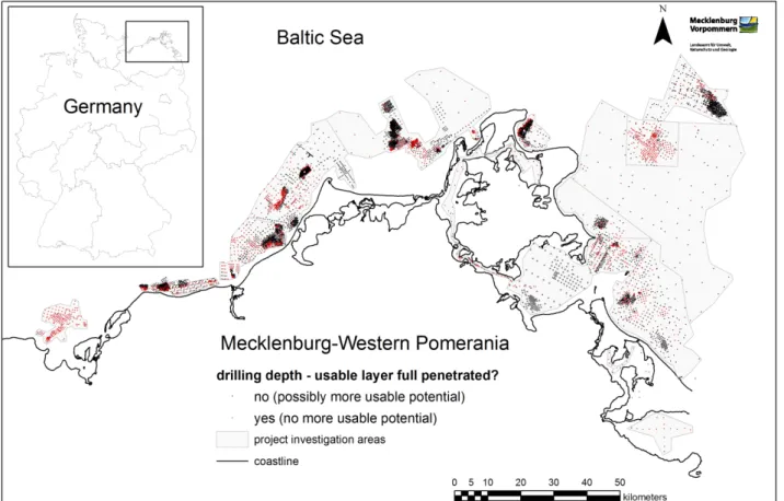
During the first project phase the distribution and concentration of detrital heavy minerals in offshore areas of the southwestern Baltic Sea were determined, using archival drill core information from the exploration of near-surface clastic soft-sediments on the Baltic Sea shelf conducted by the Central Geological Institute (ZGI) of the former German Democratic Republic (Weinert and Stephan, 1983, 1985). A spatial examination of 21,526 heavy mineral measurements, obtained from 7,164 drilling and surface sampling locations (cf. Fig. 1) with 40,349 granulometric measurements show an aerially averaged (mineralogically undifferentiated) heavy mineral content between 0.12 and 0.93 % mass (derived from averaging the HMC from the <1.0 mm sand fraction of all available sediment cores).
For the subsequent recovery of zircon a combination of off- and onshore gravity, magnetic and electrostatic separation techniques will be applied. Further processing will separate the REE- bearing Zircon-fraction and extract the REE from the Zircon by means of environmentally friendly hydrochemical and biochemical leaching. Alternatively, various conventional chemical and as newly
developed mechano-chemical leaching techniques will be tested. A quantified estimation of the total economic resource potential will be used to evaluate the different methodologies at market conditions.
The SEEsand research project is mainly financed by the research funding "r4 – Innovative Technologies for Resource Efficiency – Research for Supplying Strategic Economic Raw Materials" of Federal Ministry of Education and Research of Germany (BMBF grant No. 033R163A).
Fig. 1: Locations of exploration drill cores within Pleistocene marine sand and gravel deposits of the SW Baltic Sea (recovered during the period 1980 until 2017).
References
Glombitza, F.; Iske, U.; Bullmann, M. and Dietrich, B., 1988. Bacterial leaching of zirkon mineral for obtaining trace and Rare Earth Elements (REE). Biohydrometallurgy, 407–418.
Weinert, G. and Stephan, W., 1983. Höffigkeitsabschätzung Kiesssande Ostseeschelf III. Teilbericht:
Bewertung des Schwermineralpotentials im Ostteil des Festlandssockels der DDR, Zentrales Geologisches Institut der DDR, Berlin. 74 pp. [unpubl., in German].
Weinert, G. and Stephan, W., 1985. Höffigkeitsabschätzung Kiesssande Ostseeschelf III. Teilbericht:
Bewertung des Schwermineralpotentials im Zentral- und Westteil des DDR-Festlandssockels, Zentrales Geologisches Institut der DDR, Berlin. 106 pp. [unpubl., in German].
The southwestern sector of the Weichselian Scandinavian Ice Sheet: Facts and knowledge gaps Böse, Margot1*; Hardt, Jakob1 and Lüthgens, Christopher2
1 Freie Universität Berlin, Institute of Geographical Sciences, Malteserstr. 74-100, 14195 Berlin, Germany
2 BOKU, University of Natural Resources and Life Sciences, Vienna, Institute of Applied Geology, Peter-Jordan-Straße 82, 1190 Wien, Austria
* E-mail corresponding author: m.boese@fu-berlin.de
Some progress was made in dating of Weichselian sediments in the south-western sector of the Scandinavian Ice Sheet (SIS) in Sweden, Denmark and Germany. Most ages are based on luminescence dating of glaciofluvial and glaciolacustrine sediments, and cosmogenic nuclide exposure dating of glacial boulders. The increasing number of numerical data gives new insights into the timing of various glacigenic, glaciofluvial and glacilimnic processes (Hughes et al., 2015). In Germany, the traditional names of ice advances like Brandenburg, Frankfurt and Pomeranian advance pretend a synchronous formation of ice marginal positions over some distance, not taking into consideration the varying ice dynamics at the distal part of the SIS. In this study, we review existing data and present a revised model of Weichselian ice dynamics in the SW sector of the Baltic Sea.
During MIS 4 and/or the early MIS3, according to the present knowledge, the Ellund-Warnow advance marks the first expansion of glaciers during the Weichselian into the SW Baltic Sea area.
But it is only lithostratigraphically documented in western Mecklenburg and in parts of northern Schleswig-Holstein. Morphological features are missing as well as geochronological data.
During late MIS 3, the ice attained the maximum extent within the Oder lobe (Brandenburg advance) and reached into western Denmark (Klintholm advance) (Hardt et al., 2016, Hardt, 2017).
Nevertheless, there is no evidence that Bornholm, the Rønne Bank as well as Rügen were overridden by ice at that time; instead (glacio-)fluvial processes are documented and glaciolacustrine sediments were deposited in ice dammed lakes. The maximum ice advance of the Oder lobe is dated to 32-28 ka by samples from glaciofluvial material at the southernmost ice marginal position as well as in the hinterland. The results correspond with the morphological and sedimentological observations. The area is mainly characterized by meltwater sediments and erosional channels, which are in accordance with the assumption of a fast flowing ice of an outlet glacier. Distinct terminal moraines are missing, and the till is about 2 m thick. In western Mecklenburg as well as in Schleswig-Holstein no data are available so far.
The ice advance in correspondence with the global LGM at about 22-20ka, is named Pomeranian advance in NE Germany, (Lüthgens & Böse, 2011, Lüthgens et al., 2011). This phase was likely characterized by slower moving ice and a steady state situation at the ice margin, what can be deduced from the boulder-rich and distinct end moraines in northern Brandenburg. In western Mecklenburg, data of sediments of similar processes are missing, and the morphological situation is not so clear. The complex and overlapping ice advances in Schleswig-Holstein are not yet well dated.
But isochronic ice cover is also documented in the Baltic Sea basin, at the German coastal cliffs in Mecklenburg-Vorpommern and in Denmark.
Thus, various sedimentary environments existed in close neighborhood in the southwestern Baltic Sea basin and the surrounding areas, shedding new light on ice dynamics. The cosmogenic nuclide data of boulders represent the down wasting of the ice cover and the stabilization of the landscape which can last until the melting of dead ice in the subsurface. Therefore these ages represent different processes.
The configuration and dynamics of the SIS in its southwestern part were obviously very different during the MIS 3 and MIS 2 ice advances, influenced by climatic parameters, and the topography of the Baltic Sea basin and adjacent areas.
References
Hardt, J., 2017. Weichselian Phases and Ice Dynamics of the Scandinavian Ice Sheet in Northeast Germany. Dissertation, Freie Universität Berlin, 137 pp., Berlin. https://refubium.fu-
berlin.de/handle/fub188/381.
Hardt, J., Lüthgens, C., Hebenstreit, R. and Böse, M., 2016. Geochronological (OSL) and geomorphological investigations at the presumed Frankfurt ice marginal position in northeast Germany. Quaternary Science Reviews 154, 85–99.
Hardt, J. and Böse, M., 2016. The timing of the Weichselian Pomeranian ice marginal position south of the Baltic Sea: A critical review of morphological and geochronological results.
Quaternary International. http://dx.doi.org/10.1016/j.quaint.2016.07.044.
Houmark-Nielsen, M., 2010. Extent, age and dynamics of Marine Isotope Stage 3 glaciations in the southwestern Baltic Basin. Boreas 39, 343–359. http://dx.doi.org/10.1111/j.1502-
3885.2009.00136.x.
Hughes, A.L.C., Gyllencreutz, R., Lohne, Ø.S., Mangerud, J. and Svendsen, J.I., 2015. The last Eurasian ice sheets – a chronological database and time-slice reconstruction, DATED-1.
Boreas 45, 1–45. http://dx.doi.org/10.1111/bor.12142.
Lüthgens, C. and Böse, M., 2011. Chronology of Weichselian main ice marginal positions in north- eastern Germany. E&G Quaternary Science Journal 60, 236–247.
Lüthgens, C., Böse, M. and Preusser, F., 2011. Age of the Pomeranian ice-marginal position in northeastern Germany determined by Optically Stimulated Luminescence (OSL) dating of glaciofluvial sediments. Boreas 40, 598–615.
The isotopic composition of groundwater in the Baltic–White Sea region as a reflection of geographical and climatic evolution in the Late Pleistocene-Holocene
Borodulina, Galina1*; Tokarev, Igor2; Voroniuk, Grigory3 and Subetto, Dmitry4
1 Northern Water Problems Institute, Karelian Research Centre of Russian Academy of Sciences, Petrozavodsk, Russian Federation
2 Center for X-ray Diffraction Studies at the Research Park of St. Petersburg State University, St.
Petersburg, Russian Federation
3 Herzen State Pedagogical University of Russia, St. Petersburg, Russian Federation
4 JSC “Petersburg Integrated Geological Expedition” of Rosgeology, St. Petersburg, Russian Federation
* Corresponding author: bor6805@yandex.ru
Significant change in the configuration and water levels of paleo water reservoirs which took place in the Late Pleistocene and Holocene are the distinctive features of the Baltic Sea – White Sea region. Groundwater can reflect the history of the territory development in the geological past, so they are a paleogeography archive (Kendall, McDonnell, 1998; Ferronsky, Polyakov, 2012).
Groundwater formed during the last cold period under the influence of the Eemian Sea and the Baltic Ice Lake, and also cryogenic metamorphism was discovered.
The present paper is based on studies of deuterium (δ2Н), oxygen-18 (δ18О), tritium (3Н) and uranium (234U/238U) to uncover the conditions of the groundwater formation and assess the effect of climate changes on aquifers. Isotope tracers were applied for groundwater dating and to identify the processes of evaporation or freezing in past. Studies were carried out in 2005–2017 and included monitoring of atmospheric precipitations, analyses of GNIP IAEA database (the WISER tool on https://websso.iaea.org/), snow surveys and testing of surface water and groundwater. The research concerned the formation of unique groundwater composition in some sites including the southeastern part of the Baltic shield hydrogeological massif, east part of Baltic Artesian Basin (in the Leningrad region and the Karelia) and west part of the North Dvina artesian basins (Eemian Sea). The iodine groundwater is formed in North Dvina River valley in the upper part of the Vendian sand- and siltstones (Vpd) under marine clay (mQIIImk) on the depth near 100 m. The highest iodine content is 40 mg/L), groundwater salinity varies from 15 to 25 g/l. The iodine water has a relatively heavy isotopic composition (from δ2H=−38‰ and δ18O=−5.2‰ to δ2H=−69‰ and δ18O=−10.1‰) which is shifted to right from GMWL (Global Meteoric Water Line) and the uranium-234 enrichment (234U/234U ratio from 4.3 to 6.8 by activity). The formation of the water iodine anomaly apparently included two consecutive stages: 1) burial of the saline and isotopically heavy waters together with the organic material containing bound iodine, within the clay complex of the Eemian Sea; 2) freezing of the geological strata, accompanied by the release of iodine from the organic matter and the displacement of residual water down to the clay basement as a result of the pore pressure increase during the underground ice formation.
The fresh ferruginous (highest iron content 147 mg/l) groundwater is formed in the oxidation zone of the schungite- and pyrite-bearing of the Lower Proterozoic crystalline rocks in the western part of the Onega structure (Karelia, spa “Marcial Waters Resort”). The isotope tracers (δ2Н, δ18О, δ13C, 3He, 234U/238U, 3H) in groundwater have strongly changed over the past 30 years (Tokarev et al., 2015). Early data indicated the cryogenic metamorphism under partial water freezing in the last glacial period. Now we observe a rapid penetration of meteoric water and a gradual vanishing of the "old" component. At the same time, the major chemical composition of water did not change.
This is possible only if the beneficial balneological agent (iron) comes with the young water
component. In turn, this means rapid equilibration in the water-rock system due to the presence of iron in the easily soluble compounds. Most likely, these are the secondary sulfates formed during the glaciation period during oxidation of sulphides in the black shales. The most intense oxidation process proceeded during the Weichselian cooling, when the general decrease in the level of groundwater, the increase in oxygen content, and the decrease in the organic content in the frozen zone happened.
The Riphean and Vendian aquifers of Baltic artesian basin located south of the Baltic
hydrogeological massif. On some sites the isotopic composition of groundwater are extremely depleted up to δ18O=−22‰ and δ2H=−170‰ at the Tallinn water intake (Raidla et al., 2009) and identified as the waters recharged in cool climate conditions at the end of the Pleistocene or at the beginning of the Holocene period .
The presented materials allow us to formulate a conceptual model of the influence of geographic and climatic variations in the Baltic Sea – White Sea region at the end of Pleistocene and in Holocene on the groundwater formation.
A) Eemian interglacial – sea level rising and intrusion of seawater in aquifers near shoreline;
B) Weichselian glaciation – freezing of the geological section in areas not occupied by ice, squeezing down of residual water (cryopegs) in the geological section with simultaneous cryogenic metamorphism of chemical and isotopic composition, penetration of fresh meltwater during thawing of ice at the sheet bottom, the appearance of oxidizing conditions;
C) The end of the glaciation – recharging of the aquifers in coastal zone with fresh water intrusion during the Baltic Ice Lake, the appearance of “regenerated waters” in case of permafrost thawing;
D) Holocene – discharge of groundwater into the modern water reservoirs.
The study was supported by Russian Science Foundation (project № 18-17-00176), Russian Foundation for Basic Research (project № 18-45-100004).
References
Kendall, C. and McDonnell, J.J., 1998. Isotope Tracers in Catchment Hydrology. Elsevier Science, Amsterdam.
Ferronsky, V.I., Polyakov, V.A., 2012. Isotopes of the Earth's Hydrosphere. Springer Science &
Business Media, Dordrect, Heidelberg, London, New York.
Tokarev, I.V., Borodulina, G.S., Blazhennikova, I.V., Avramenko, I.A., 2015. Conditions for the formation of ferruginous mineral waters according to isotope-geochemical data (spa
“Marcial Water Resort”, Karelia). Geochemistry 1, 88–91. (In Russian).
Raidla, V., Kirsimäe, K., Vaikmäe, R., Jõeleht, A., Karro, E., Marandi, A., Savitskaja, L., 2009.
Geochemical evolution of groundwater in the Cambrian-Vendian aquifer system of the Baltic Basin. Chem. Geol. 258, 219–231.
Did the Baltic Ice Stream exist during the Late Saalian? New data from the northern Wielkopolska and Eastern Pomerania regions, Poland
Czubla, Piotr1* and Sokołowski, Robert J. 2
1 Institute of Earth Science, University of Łódź, ul. Narutowicza 88, 90-139 Łódź, Poland
2 Institute of Oceanography, University of Gdańsk, al. Piłsudskiego 46, 81-378 Gdynia, Poland
* E-mail corresponding author: piotr.czubla@geo.uni.lodz.pl
The last Saalian ice advance took place approximately 155-135 ka BP (Penultimate Glacial Maximum – PGM). Vast areas of Central Europe were covered by an ice sheet which left thick series of glacial deposits. The question is: what was the direction of the ice inflow into the area of contemporary Poland in the late MIS-6? To find the answer, we investigated glacial deposits in the Northern Wielkopolska and Gdańsk Pomerania regions. One of the best exposures of the Late Saalian is located in the Wapienno quarry, northern Wielkopolska region. The till unit B1 (Sokołowski, 2007; Wysota et al., 2009) consists of brown sandy diamicton, up to 4 m thick, predominantly massive, with poorly visible lamination in the uppermost part. In the northern part of the Wapienno quarry, B1 till lies directly on the Upper Jurassic limestones exploited in the quarry, whereas in the southern part of quarry, it is underlain by the sandy Wapienno Formation. The lower part of unit B1 comprises a layer of boulder pavement with ploughing structures. Till facies formed as a result of subglacial deformation combined with ploughing, lodgement and melt-out processes.
Striae orientation on the pebble surfaces and Jurassic bedrock and till fabric measurements indicate the west to south-east ice movement (azimuth: 110°) (Sokołowski and Czubla, 2016). The same directions of glacial striae and till-fabrics were detected in neighboring key sites in Barcin, Młodocin and Dębówko Nowe. Although this is only an indicator of the local direction of ice movement, the inflow of ice from the western part of Fennoscandia is confirmed by the petrographic analysis of the fine gravel fraction in which there is only a slight predominance of sedimentary rocks over crystalline rocks. Similar conclusions were also drawn from the analysis of erratics in the fraction over 20 mm, carried out in Barcin, Młodocin, Dębówko Nowe and Wapienno sites. The maps of the erratic source areas show the balanced participation of Dalarna, Uppland, Småland, the bottom of the Baltic Sea and the Åland Islands in supplying rock material to the ice sheet which deposited the analyzed till.
Erratics from western Sweden, Blekinge and Bornholm are rather rare in the Late Saalian tills in the northern Wielkopolska region. No rocks from Norway nor from mainland Finland were found in these deposits. Thus, it can be concluded that the analyzed ice mass was moving along the western edge of the Baltic Sea depression. Probably its path led across eastern Sweden (perhaps along the Baltic coast) and left the Baltic Sea depression towards the south.
Theoretical boulder centers (TBC – for the method, see Lüttig, 1958; Meyer, 1983; Czubla, 2001, 2015) of the B1 till in both studied profiles are shifted towards the southwest (16.16ºE;
58.21ºN in the western part of the pit and 15.97ºE; 58.45ºN in the eastern part) compared to the same parameters calculated for the younger glacial levels in Wapienno (Sokołowski and Czubla, 2016).
The TBC indicators calculated for tills in other outcrops under study (Barcin, Młodocin, Dębówko Nowe) yielded similar results. Therefore, we decided to investigate the same features of Late Saalian glacial deposits far to the north from these sites in Łęczyce near Lębork, northern Poland. The Late Saalian till in Łęczyce contains significantly more erratics from Åland regions, but the ratios between groups of indicator erratics originating in other regions of Fennoscandia are close to those found (observed) in northern Wielkopolska. As a result of the higher number of Åland rocks, a shift of TBC to the north-east can be observed. Initially, the Late Saalian ice flowed to the south
most probably along the present-day Swedish coast, but in the final stage it turned to the east. The movement of ice from NW Fennoscandia is confirmed by erratics incorporated in southern Sweden and Bornholm.
The Scandinavian stage of ice flow is rather typical, but it is very hard to explain and justify the return of ice toward the east, which probably occurred in the southern part of the Baltic Basin close to the modern shoreline. A possible (hypothetical) ice stream (the older equivalent of the Baltic Ice Stream, if such existed) should have blocked the ice mass route to the south, and forced outflow towards the west, into the Danish straits. Numerous rocks from Bornholm and southern Sweden found in tills in Pomerania contradict this hypothesis.
Perhaps, during the Late Saalian, the western part of the Fennoscandian ice sheet developed (increased its range) faster than the eastern one and, therefore, in lower latitudes, the direction of ice movement was changing to the east. We speculate that this could have been caused by climatic factors, i.e. bigger humidity and, consequently, more frequent and larger snowfall which decreases with increasing distance from the Atlantic Ocean. In the light of petrographic analyses, no equivalent of the Baltic ice stream (sensu Punkari, 1997) existed in PGM.
References
Czubla, P., 2001. Eratyki fennoskandzkie w utworach czwartorzędowych Polski Środkowej I ich znaczenie stratygraficzne. Acta Geographica Lodziensia 80, 1–174.
Czubla, P., 2015. Eratyki fennoskandzkie w osadach glacjalnych Polski i ich znaczenie badawcze.
Wydawnictwo Uniwersytetu Łódzkiego, Łódź, 335 pp.
Lüttig, G., 1958. Methodische Fragen der Geschiebeforschung. Geologisches Jahrbuch 75, 361-418.
Meyer, K.-D., 1983. Indicator pebble and stone count methods. In: Ehlers J. (ed.) Glacial deposits in North-West Europe, Balkema, Rotterdam, 275–287.
Punkari, M., 1997. Glacial and glaciofluvial deposits in the interlobate areas of the Scandinavian ice sheet. Quaternary Science Reviews 16, 7, 741–753.
Sokołowski, R.J., 2007. Struktura i procesy sedymentacji osadów plejstoceńskich w Wapiennie. In:
Molewski P, Wysota W. and Weckwerth P, (eds.) Plejstocen Kujaw i dynamika lobu Wisły w czasie ostatniego zlodowacenia, XIV Konferencja – Stratygrafia Plejstocenu Polski.
Wydawnictwo Państwowego Instytutu Geologicznego, Warszawa, 139–145.
Sokołowski, R.J. and Czubla, P., 2016. Sequence of Pleistocene deposits in the Wapienno quarry, north-central Poland. In: Sokołowski R.J. and Moskalewicz D. (eds.) Quaternary geology of north-central Poland: from the Baltic coast to the LGM limit, 69–84.
Wysota, W., Molewski, P. and Sokołowski, R.J., 2009. Record of the Vistula ice lobe advances in the Late Weichselian glacial sequence in north-central Poland. Quaternary International 207, 26–41.
The Late Pleistocene-Early Holocene palaeoenvironmental evolution in the SE Baltic region:
a multi-proxy palaeolimnological approach based on the Kamyshovoe Lake record Druzhinina, Olga1,2*, Stančikaitė, Miglė3, Kublitskiy, Yury2, Nazarova, Larisa4,5,6, Syrykh, Ljudmila2,
Gedminienė, Laura3, Vaikutienė, Giedrė7 and Subetto, Dmitry2
1 Shirshov Institute of Oceanology, Russian Academy of Sciences, 36, Nahimovskiy prospekt, 117997 Moscow, Russia
2 A. Herzen State Pedagogical University, Nab. Moyki 48, St. Petersburg, 191186, Russia
3 Nature Research Centre, Institute of Geology and Geography, Akademijos Str. 2, 08412 Vilnius, Lithuania
4 Potsdam University (The Institute of Earth and Environmental Science), Am Neuen Palais 10, 14469 Potsdam, Germany
5 Alfred Wegener Institute, Helmholtz Centre for Polar and Marine Research, Research Unit Potsdam, Telegrafenberg A43, 14473 Potsdam, Germany
6 Kazan Federal University, Kremlyovskaya str., 18, 420018 Kazan, Russia
7 Vilnius University, M. K. Čiurlionio 21/27, 03101 Vilnius, Lithuania
* E-mail corresponding author: olga.alex.druzhinina@gmail.com
The Kamyshovoe Lake (54 22 605` N, 22 ° 42 790` E, 189 m a.s.l.) sedimentary record in the southeastern Baltic Sea Region was studied to reconstruct climatic fluctuations and abiotic responses to them during Late Glacial and Early Holocene time. New results of geochemical, chironomid, isotopic, and palaeomagnetic data analysis were correlated with earlier evidence for lithological and palynological changes in the Kamyshovoe Lake record (Kublitsky et al., subm.). The fragment of the record studied encompassed an interval between ca. 16 000 and 6 500 cal. a BP.
The results obtained have led the authors to the following conclusions:
1. Palaeoclimatic chironomid-inferred reconstruction reflects summer temperature fluctuations of approximately 5°C over the period of ca. 15 300 – 6 800 cal. a BP. Mean July temperature was shown to increase from ca. 15 300 to 14 370 cal. a BP with an exceptionally high reconstructed temperature (19.8°C). A decreasing trend for summer temperatures is observed between 14 370 and 12 000 cal. a BP, when a minimum temperature (11.5°C) was recorded.
A steady but very smooth rising temperature trend with fluctuations between 12.5 and 14.0°C persisted until ca. 9 800 cal. a BP, when a warmer period (14.1 – 16.0°C) began.
2. The Kamyshovoe Lake sequence reflects clear environmental responses to short-term early Holocene climatic oscillations superimposed upon general warming: about 11 300 cal. a BP, 10 700 – 10 500 cal. a BP, and 10 000 – 9 800 cal. a BP. These cooling events are diagnosed by chironomid analysis and changes in the palynological spectrum, geochemical record and lithostratigraphy of the sediments.
3. Despite marked changes in the vegetation around Kamyshovoe Lake at the onset of the Holocene climatic warming dated at 11 700 cal. a BP, no clear sediment responses at that time have been detected. All available data, including recent geochemical, isotopic and palaeomagnetic evidence, prove that both the terrestrial and limnic environments remained unstable until ca. 11 500 cal. a BP, when the sedimentation environment began to transform markedly.
The detailed study of bottom sediments from Kamyshovoe Lake has considerably expanded our knowledge of the climate and changes in the lake systems in the southeastern Baltic Sea Region at the Pleistocene-Holocene boundary. The results obtained show the significance of local factors and conditions which, together with global processes, could be responsible for differences in the response of natural systems to global trends. The study of Kamyshovoe Lake shows that in this case differences were indicated by the non-simultaneous and unequally distinct pattern of the response of individual natural components to global changes in climate.
Acknowledgements – The expeditional part of this research was done with a support of the state assignment of IO RAS (Theme No. 0149-2019-0013). The laboratory studies (Chironomid analysis) were supported by the RSF (grant No.18-77-10016) and the Deutsche Forschungsgemeinschaft (DFG) Project NA 760/5-1 and DI 655/9-1. This study was partly financed by the S-MIP-17-133 from the Research Council of Lithuania.
References
Kublitskiy, Y., Druzhinina, O., Stančikaitė, M., Nazarova, L., Syrykh, L., Gedminienė, L., Uogintas, D., Skipityte, R., Arslanov, Kh., Vaikutienė, G., Kulkova, M. and Subetto, D. (submitted). The Late Pleistocene - Early Holocene Palaeoenvironmental Evolution in the SE Baltic Region,
Kaliningrad District, Russia: a new approach based on chironomid, geochemical and isotopic data from Kamyshovoe Lake. Boreas.
