Polarforschung 87 (1), 23 – 31, 2017
Case Studies of the Role of Arctic Gateways in Plio-Pleistocene Arctic Changes
by Robert F. Spielhagen1
Abstract: The configuration of the Arctic Ocean as a mediterranean sea, surrounded by continents, gives a particular importance to the few connections that exist to the world ocean. In this manuscript critical cases are examined when the Arctic Ocean played an important role in climatic changes occur- ring over long and short geological timescales. By presenting three examples of published research results it is shown that in particular the water mass exchange through Bering Strait and the Fram Strait has varied in direction and volume. These variations have caused significant changes in the environments in the Arctic Ocean itself, on the surrounding continents, and – in cases – even hemisphere-wide. Owing to the prominent role of the Arctic Ocean in the global ocean circulation system, studies of the role of Arctic gateways are key to a better understanding of past, present, and future changes.
Kurzfassung: Die Lage des Arktischen Ozeans als ein „Mittelmeer“, umgeben von Kontinenten, weist den wenigen Verbindungen zum Welt- ozean eine besondere Bedeutung zu. In diesem Manuskript wird anhand von Fallbeispielen die Rolle des Arktischen Ozeans im Verlauf von Klimaverän- derungen über lange und kurze geologische Zeitskalen untersucht. Anhand dreier Beispiele und publizierter Ergebnisse wird gezeigt, dass insbeson- dere der Wassermassenaustausch durch die Beringstraße und die Framstraße bezüglich Richtung und Wassermengen variierte. Diese Variationen haben bedeutende Veränderungen der Umweltbedingungen im Arktischen Ozean selbst, auf den umgebenden Kontinenten und – in bestimmten Fällen – sogar Hemisphären-weit hervorgerufen. Wegen der Bedeutung des Arktischen Ozeans im globalen Ozeanzirkulationssystem sind Untersuchungen über die Rolle der arktischen Meeresstraßen ein wesentlicher Schlüssel für ein besseres Verständnis vergangener, heutiger und zukünftiger Veränderungen.
INTRODUCTION
The Arctic Ocean with its perennial ice cover is a unique feature in the global ocean. It is surrounded by continents from where huge rivers discharge enormous amounts of freshwater which accumulates in the uppermost water layer and helps to maintain the ice cover. In contrast to all other oceans, the deeper waters show higher temperatures than the surface layer.
This unusual water mass structure is the result of the northern position and the narrow connections which only allow a chan- nellized water mass exchange with the world ocean. In the geological past several factors have influenced the intensity and direction of these water mass exchanges. Among these factors, plate tectonic configurations, sea level variations (both eustatic and isostatic), additional water sources, and changes in the current systems were most important. In this collection of published results, three critical time intervals and events are discussed, when changes in the connections to neighbouring
____________
Keywords: Arctic Ocean, gateways, paleoceanography, Pliocene, Quaternary doi:10.2312/polarforschung.87.1.23
1 GEOMAR Helmholtz Centre for Ocean Research Kiel, Wischhofstraße 1-3, D-24148 Kiel, Germany, <rspielhagen@geomar.de>
This paper was presented as an oral report at the conference „Das Klima der Arktis – Ein Frühwarnsystem für die globale Erwärmung“ at the Akademie der Wissenschaften und der Literatur zu Mainz, 02-03 November 2016.
Manuscript received 03 May 2017; accepted in revised form 08 September 2017.
ocean basins or in the oceanic systems in the straits caused significant feedbacks in the Arctic land–ocean–ice system. In cases, the effects were reaching far beyond the Arctic circle.
PHYSIOGRAPHY AND OCEANOGRAPHY OF ARCTIC GATEWAYS
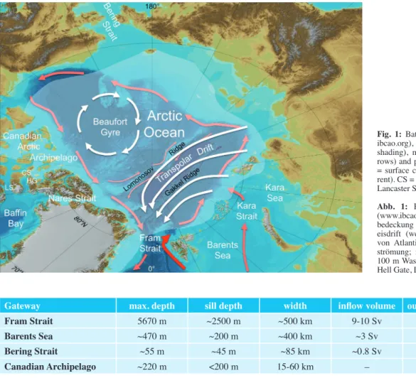
When excluding the Norwegian-Greenland Sea, about half of the remaining about 11.8 million km2 area of the Arctic consists of deep-sea environments with a maximum depth of ca. 5750 m in the central valley of the actively spreading Gakkel Ridge (Fig. 1). The Fram Strait comprises the single deepwater connection to the world ocean. Other connections exist only across the marginal seas, which account for the other half of the area. The Barents Sea as the westernmost of the Eurasian marginal seas represents a broad connection to the northern North Atlantic, while the Bering Strait (between Alaska and easternmost Siberia) and the straits through the Canadian Arctic archipelago are relatively narrow (<100 km in width; Tab. 1).
About 75 % of the advection of saline and relatively warm Atlantic Water occurs through the eastern Fram Strait (cf. Tab.
1 with references). The remaining volume of ca. 3 Sv takes a north-eastern route across the Barents Sea and enters the Arctic Ocean mostly through the Kara Strait and across the northern Kara Sea continental margin (Fig. 1). The deep Fram Strait is also the major outlet for waters from the Arctic. In its western part, cold, low-saline and ice-covered surface waterss are exported to the Norwegian-Greenland Sea. At depth in the western Fram Strait, modified Atlantic Water from the Arctic Ocean interior is flowing southward and compensating for the inflow in the eastern part.
As a whole, flow through the Bering Strait represents a net transport of freshwater from the North Pacific to the Arctic Ocean although the shallow inflow is significantly more saline than the Arctic near-surface waters. In contrast, the various narrow straits in the Canadian Arctic Archipelago (CAA) are pathways for a freshwater export from the Arctic Ocean to the Baffin Bay. The most important ones are Nares Strait, Cardigan Strait, Lancaster Sound and Hell Gate. These straits account for less than 20 % of the water outflow, but consid- ering only the liquid freshwater export, their role is more important (Beszczynska-Möller et al. 2011).
FIRST BERING STRAIT OPENING AND ITS ROLE IN PLIOCENE GLOBAL COOLING
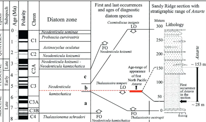
The opening of the Fram Strait in the Upper Eocene or Lower Miocene had connected the Arctic deep-sea basin to the world ocean and provided a passage for deep-water exchange (for a discussion see stein this vol.). Since all other straits were closed until the latest Miocene, for more than 10 million years (m.y.) the Arctic Ocean resembled the modern Mediterranean Sea. Only at 5.5-5.4 m.y. a connection to the North Pacific was established, as revealed by the occurrence of the Atlantic and Arctic bivalve Astarte borealis in sediments of the Milky River Formation at the Sandy Ridge site on the Alaska Penin- sula (Fig. 2; Gladenkov et al. 2002). Characteristic diatoms found enclosed in Astarte specimens allowed to narrow the age interval of the first occurrence to the uppermost Miocene.
Gladenkov et al. (2002) supposed that a combination of regional tectonic movements in the northern Bering Sea region and an eustatic sea level rise led to a flooding of the Bering Strait and the first separation of Asia and North America since the Late Cretaceous.
The findings of Astarte specimens in South Alaskan sediments indicate a southward flow direction through Bering Strait after the opening. About 1 m.y. later the flow direction reversed, as
Fig. 1: Bathymetry of the Arctic Ocean (www.
ibcao.org), mean summer sea ice coverage (white shading), mean sea-ice drift patterns (white ar- rows) and pathways of Atlantic Water (red arrow
= surface current; pink arrows = subsurface cur- rent). CS = Cardigan Strait, HG = Hell Gate, LS = Lancaster Sound.
Abb. 1: Bathymetrie des Arktischen Ozeans (www.ibcao.org), mittlere sommerliche Meereis- bedeckung (weiße Schattierung), gemittelte Meer- eisdrift (weiße Pfeile) und Ausbreitungsmuster von Atlantikwasser (roter Pfeil = Oberflächen- strömung; rosa Pfeil = Strömung unterhalb ca.
100 m Wassertiefe). CS = Cardigan Strait, HG = Hell Gate, LS = Lancaster Sound.
Gateway max. depth sill depth width inflow volume outflow volume reference
Fram Strait 5670 m ~2500 m ~500 km 9-10 Sv ~11 Sv 1, 2
Barents Sea ~470 m ~200 m ~400 km ~3 Sv minor 2, 3, 4
Bering Strait ~55 m ~45 m ~85 km ~0.8 Sv – 2, 5
Canadian Archipelago ~220 m <200 m 15-60 km – 1.7-2.0 Sv 2, 6
Tab. 1: Physiography and water mass exchange through the Arctic gateways, with reference to the Arctic Ocean. References: (1) = Marnela et al. 2016, (2) = Beszczynska-Möller et al. 2011, (3) = GaMMelsrød et al. 2009, (4) = oziel et al. 2016, (5) = WoodGate et al. 2006, (6) = Wekerle et al. 2013.
Tab. 1: Physiographie und Wassermassenaustausch durch arktische Meeresstraßen, jeweils mit Bezug auf den Arktischen Ozean. Quellen: (1) = Marnela et al.
2016. (2) = Beszczynska-Möller et al. 2011. (3) = GaMMelsrød et al. 2009. (4) = oziel et al. 2016. (5) = WoodGate et al. 2006. (6) = Wekerle et al. 2013.
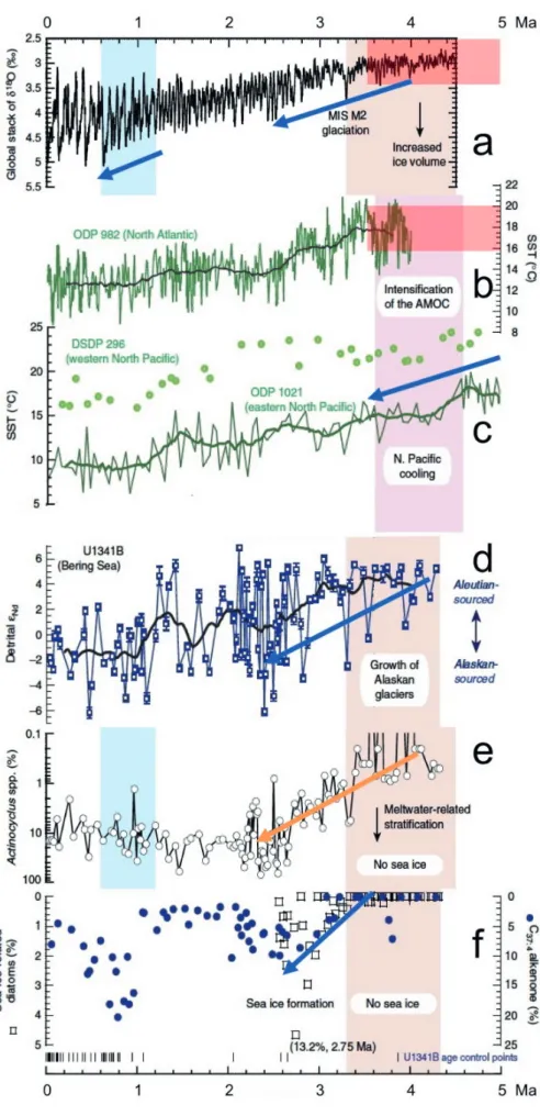
documented by the invasion of mollusks (e.g., Mya arenaria) of undoubted North Pacific origin to the North Atlantic region where they can be found in Late Pliocene sediments from Iceland, the southern North Sea area and Virginia (see Marincovich (2000) for references to findings). The oldest Mya arenaria-bearing Pliocene layers on the Tjörnes penin- sula on northern Iceland were previously thought to be from the Late Pliocene (~3.5 Ma, Marincovich 2000), but more recent investigations on dinocysts from the respective beds (verhoeven et al. 2011, de schepper et al. 2015) suggest an Early Pliocene age (~4.5 Ma). A recent compilation of sea-sur- face temperature (SST) data (Fedorov et al. 2013) shows that this was a time of particularly warm conditions in the North Pacific and North Atlantic. A trend to lower SSTs in the eastern North Pacific started as early as 4.5 Ma (lariviere et al. 2012; Fig. 3c), contemporaneous with the onset of a cooling trend in the Nordic Seas (de schepper et al., 2015).
A compilation of older records from DSDP and ODP sites, however, shows that sea surface temperatures (SSTs) in the North Atlantic apparently remained on a high level (>15 °C on the Rockall Plateau; Fig. 3b) until ~3.4 Ma (laWrence et al. 2009). The flow reversal through Bering Strait is consid- ered to play a major role for the northern hemisphere cooling which is well-expressed in the global stack of benthic oxygen isotope records (Fig. 3a) by the onset of a trend towards higher
Fig. 2: Stratigraphical position, lithological sequence and diatom zonation for the Sandy Ridge site (southern Alaska). The layer with first occurrences of Astarte bivalves is indicated (red). Figure is modified from Gladenkov et al. (2002). The time scale has been adjusted to the most recent version (Gradstein et al. 2012).
Abb. 2: Stratigraphische Position, lithologische Abfolge und Diatomeenzonierung für den Sandy Ridge-Aufschluss (südl. Alaska). Die Schicht mit dem ersen Auftreten von Astarte-Muscheln ist rot markiert. Umgezeichnet nach Gladenkov et al. (2002). Die Altersskala wurde an die neueste Version (Gradstein et al.
2012) angepasst.
values after ~4 Ma (liesicki & rayMo 2005). Using multi- proxy records from IODP Site U1341B in the southern Bering Sea, horikaWa et al. (2015) could reveal the environmental changes occurring south of the gateway. They interpreted a trend from positive (radiogenic) to negative (non-radiogenic) eNd values of the detrital fraction in sediments at Site U1341B as a change from Aleutian to Alaskan sources, indicating a stronger erosion caused by the growth of Alaskan glaciers (Fig. 3d). From the same site, the authors obtained records of specific siliceous algae and biomarkers which point to cooling, enhanced stratification, and intensified sea-ice coverage in the southern Bering Sea (Figs. 3e, 3f). Utilizing dinocyst records from the Nordic Seas, de schepper et al. (2015) could show that cooling in the Nordic Seas preceded global cooling by
~0.5 My. In a similar manner, both de schepper et al. (2015) and horikaWa et al. (2015) argue for a chain of events: The Central American Seaway closed during the Pliocene and formed the Isthmus of Panama. Because of the inhibition of Atlantic-Pacific water mass exchanges the salinity difference between the North Atlantic and the North Pacific became more pronounced. When the northward export of cold and low- saline waters from the Bering Sea started, the stratification in the Arctic Ocean was reinforced and a stronger output of low-saline waters towards the North Atlantic was estab- lished. This allowed for stronger gradients and major sea-ice formation in the Nordic Seas (as demonstrated by knies et al.
2014) and intensified formation of North Atlantic Deep Water.
Further, it started an oceanic-climatic isolation of Greenland, eventually resulting in a growth of the Greenland Ice Sheet.
According to this hypothesis, developments in the Bering Strait area, initiated by tectonic movements and eustatic sea level rise, had severe consequences for the other side of the
northern hemisphere and, through the more vigorous deep- water renewal, for global ocean circulation and climate.
Recent modelling work can be seen as support for the above hypothesis. otto-Bliesner et al. (2017) show that, in the model applied, a closure of the Bering Strait (while the Barents Sea seaway and the CAA were also closed) can explain the Late Pliocene (mid-Piacenzian, 3.26-3.03 Ma) warming. This warming was a major halt in the decline of global tempera- tures towards the Pleistocene ice ages (cf. hayWood et al.
2016, for a recent review). The results of otto-Bliesner et al.
(2017) in turn emphasize the important role of an open Bering Strait for this temperature decline.
REPEATED BERING STRAIT CLOSURE AND OPENING IN THE WEICHSELIAN – A MECHANISM TO EXPLAIN SEA LEVEL VARIATIONS
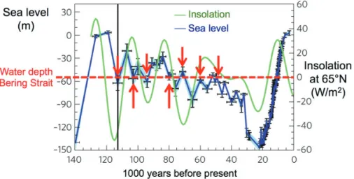
Weichselian sea level variations still appear somewhat enigmatic when insolation is considered the dominant factor for driving ice sheet growth and decay. As shown by hu et al.
(2010), sea level changes are decoupled from changes in inso- lation when 65° N is regarded a critical latitude (Fig. 4). At certain times sea level rose when insolation was decreasing, and vice versa. Further, the range between 50 and 60 m below modern often marked a threshold for trends of rising or lowering sea level. hu et al. (2010) point out that this is exactly the level, which would lead to an opening or closure of the Bering Strait. Supported by results from a state-of-art fully coupled climate model they propose that the related changes in water mass exchange between the North Atlantic/
Arctic and the North Pacific had a profound influence on the
Fig. 3: Compilation of data sets documenting the role of Bering Strait throughflow in Late Pliocene climatic developments (modified from horikaWa
et al. 2015). Blue arrows mark prominent coo- ling developments. a = Global stack of oxygen isotope records (liesicki & rayMo 2005). b = Sea surface temperatures (SSTs) in the North At- lantic at Rockall Plateau (laWrence et al. 2009).
c = trend to lower SSTs in the eastern North Pa- cific (lariviere et al. 2012). d = eNd values of the detrital fraction in sediments at Site U1341B, southern Bering Sea. e = record of specific si- liceous algae from Site U1341B. f = record of sea-ice related diatoms and biomarkers from Site U1341B.
Abb. 3: Zusammenstellung von Datensätzen zur Dokumentation der Rolle der Beringstraße im Ver- lauf klimatischer Veränderungen im Spätpliozän (umgezeichnet nach horikaWa et al. 2015). Blaue Pfeile markieren auffällige Abkühlungstrends. a = Gestapelte Sauerstoffisotopenprofile mit globaler Verteilung (liesicki & rayMo 2005). b = Mee- resoberflächentemperaturen (SST) im Nordatlan- tik (Rockall Plateau, laWrence et al. 2009). c = Trend zu niedrigeren SST im östlichen Nordpa- zifik (lariviere et al. 2012). d = eNd-Werte der detritischen Fraktion von Sedimenten an der Po- sition U1341B (südl. Beringmeer). e = Häufigkeit spezifischer Kieselalgen an der Position U1341B.
f = Relative Häufigkeit von Meereisalgen und Bio- markern an der Position U1341B.
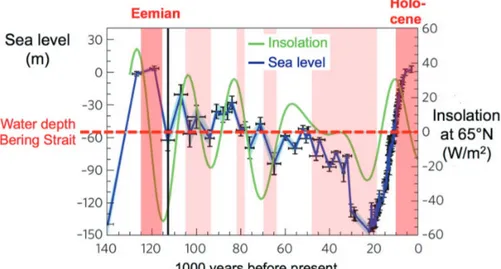
Fig. 4: Variability of global mean sea level and in- solation at 65° N with reference to the water depth of the Bering Strait. Red arrows mark times when inflections of the sea-level record occurred at the present water depth of the Bering Strait. Modified from hu et al. (2010).
Abb. 4: Gegenüberstellung der Veränderlichkeit von globalem Meeresspiegel (blau) und Insolati- on bei 65° N, mit Bezug auf die Wassertiefe der Beringstraße. Rote Pfeile markieren Zeiten, wenn Umkehrungen im Trend des Meeresspiegels bei der heutigen Wassertiefe der Beringstraße erfolg- ten. Umgezeichnet nach hu et al. (2010).
Fig. 5: Series of events trigge- red by closure (a) and opening (b) of the Bering Strait, accor- ding to the hypothesis of hu et al. (2010).
Abb. 5: Abfolge von Ereignis- sen, ausgelöst durch ein Schlie- ßen (a) bzw. Öffnen (b) der Beringstraße, entsprechend der Hypothese von hu et al. (2010).
state of deep-water renewal in the Nordic Seas, the northward heat transport, continental glaciations, and – as a result – on eustatic sea level variations. The experiments were carried out using available information on ice sheet configurations and variability. According to these data, the Barents Sea seaway was open only around ~80 and ~50 ka (laMBeck et al. 2006, 2010). Knowledge of the situation in the CAA prior to the last glacial maximum (LGM) is very sparse. hu et al. (2010) used the ice sheet size-to-sea level relation from the last deglacia- tion to define ice sheets in North America for pre-LGM times, depending on the known sea level change. Considering the
uncertainties resulting from isostatic effects, water depths and possibly existing sills, the role of the Barents Sea and CAA seaways are difficult to assess, in particular for Early and mid-Weichselian stadial and interstadial conditions. For the much warmer Pliocene, modelling experiments of hill (2015) suggest a blocking of the Barents Sea area to result in strong high latitude warming (from the focused Atlantic Water advec- tion) but an overall reduced thermohaline forcing. The CAA seaways export low-saline waters and their closure should have a positive feedback on the North Atlantic meridional overturning circulation (Wadley & BiGG 2002).
Figure 5a presents a visualization of the chain of events which, according to hu et al. (2010), occurred repeatedly during the Weichselian and affected the entire Arctic ocean–ice–climate system. Following this hypothesis, a closure of the Bering Strait turned off the freshwater inflow from the North Pacific and decreased the freshwater export to the Nordic Seas. This led to a salt accumulation in the North Atlantic, which allowed for an intensified deepwater renewal and a stronger northward heat transport by the ocean conveyor. This heat transfer to northern high latitudes should have triggered the decay of ice sheets that may have formed and, consequently, a rise of eustatic sea level which eventually led to a re-opening of the Bering Strait.
Obviously, the changes occurred on timescales of millennia and more, mostly because the decay of continental ice sheets did not happen instantaneously and rather took several thousand years.
According to hu et al. (2010), an opening of the Bering Strait started a reverse chain of events (Fig 5b). The surface waters in the Arctic Ocean freshened by inflow from the North Pacific Larger amounts of freshwater than before were exported to the Nordic Seas and diluted the salty near-surface waters there. As a consequence, the deep-water renewal was weakened and the northward heat transport, as driven by the meridional over- turning circulation, decreased so that ice sheets could grow again. This would have led to a storage of freshwater on the northern continents, a sea level drop and eventually to the closure of the Bering Strait. Again, such developments usually happened on timescales of several millennia which is in accor- dance with the observed variations in the sea level record.
The fact that several inflection points in the sea-level record (i.e., changes from sea-level rise to sea-level drop or vice versa) fall in the depth range for a closure or opening of the Bering Strait cannot be considered ultimate proof of the hu et al. (2010) hypothesis. However, we can use independent data from Arctic sediment cores to test a prediction that can be made from the hypothesis. Periods with strong Atlantic Water advection to the Arctic should fall into times when the sea level was close to or below the current depth of the Bering Strait, preferably with a negative trend. The occurrences of large amounts of planktic foraminifers in Arctic deep-sea sediments can serve as a data set for a test. They imply the presence of open waters at the time of deposition, related to the inflow of Atlantic Water through the Fram Strait and
Fig. 6: Variability of global mean sea level and in- solation at 65° N with reference to the water depth of the Bering Strait. Red bars mark times with ab- undant deposition of planktic foraminifers in the central Arctic Ocean, indicationg strong Atlantic Water inflow. Modified from hu et al. (2010).
Abb. 6: Gegenüberstellung der Veränderlichkeit von globalem Meeresspiegel (blau) und Insolation bei 65° N, mit Bezug auf die Wassertiefe der Beringstraße. Rote Balken markieren Zeiten mit hohen Gehalten von planktischen Foraminiferen in Tiefseesedimenten des Arktischen Ozeans als Hinweis auf starken Atlantikwassereinstrom. Um- gezeichnet nach hu et al. (2010).
(when possible) across the Barents Sea (spielhaGen et al.
2004). It turns out that the periods with deposition of abun- dant foraminifers indeed fall together with intervals of sinking sea level and/or variations around 50-60 m below present (Fig. 6). Exceptions are the full interglacials (Eemian, Holo- cene) when the sea level was close to modern, obviously driven by the peaks of insolation in the early part of these warm periods. Apparently the influence of the Bering Strait mechanism was restricted to times with intermediately strong insolation when the meridional overturning circulation was particularly sensitive to freshwater input. In essence, one may conclude that the Bering Strait played an important role in the ocean–ice–climate system although its influence in the Weichselian was probably strongly modulated by longer-term trends and absolute values of insolation changes.
THE FRAM STRAIT AS A BOTTLENECK FOR FRESH- WATER TRIGGERING THE YOUNGER DRYAS COLD EVENT
The Younger Dryas (YD) event was a set-back to glacial condi- tions at 12.9-11.7 ka, within the warming trend from the last glacial to the Holocene interglacial. It was felt over much of the northern hemisphere and beyond. For quite some time it has attracted the interest of paleoceanographers and paleo- climatologists, in particular because of its rapid onset which is documented, e.g., in Greenland ice cores (Fig. 7). A shut- down of the oceanic heat transport by the “Global Conveyor Belt” to northern high latitudes was considered the most likely reason for the rapid cooling. Broecker et al. (1989) proposed the diversion of freshwater from glacial Lake Agassiz, which had previously flowed southward to the Mssissippi, to the St.
Lawrence River and eventually the North Atlantic as the trigger for this event. They argued that the freshwater decreased surface salinity in the areas of deepwater formation so that the sinking of cold, saline waters and the meridional heat trans- port stopped. This hypothesis was challenged by accumulating evidence for a northward directed freshwater flow at 12.9 ka (e.g., tarasov & peltier 2005, Murton et al. 2010) from proglacial lakes Agassiz and Ojibway, which had developed south of the receding Laurentian Ice Sheet in North America.
The flow must have occurred along the Mackenzie River valley and caused an outburst of freshwater towards the Arctic Ocean.
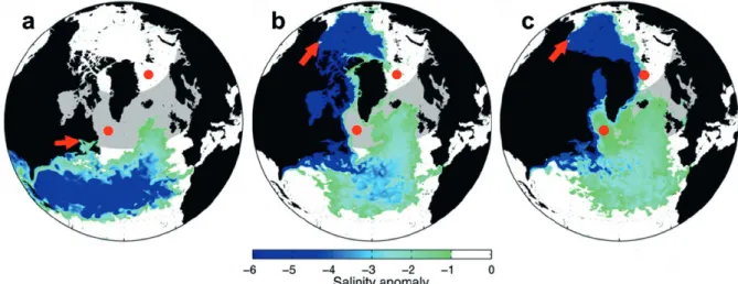
When determining the effect of a rapid freshwater release to the Arctic Ocean, the gateways to the areas of deep-water renewal become an important issue. condron & Winsor (2012) have tested the effect of different gateway configu- rations with respect to the sea surface salinity change in the North Atlantic. The results of their realistic experiments with a state-of-the-art high-resolution, global coupled ocean sea-ice circulation model reveal that the salinity change in today's areas of vertical convection can be fundamentally different, depending on the location where the freshwater is released and where it is transported afterwards (Fig. 8). A freshwater outburst through the St. Lawrence river is unlikely to reach the Greenland or Labrador Seas, instead the freshening will affect mostly the area south of 50° N (Fig. 8a). Considering an outburst through the Mackenzie River valley at the onset of the YD event, it is important whether freshwater could escape the Arctic Ocean through the Canadian Arctic Archipelago. With the archipelago open, a large portion of the freshwater would flow south-eastward to Baffin Bay and, as a boundary current along the Newfoundland coast into the North Atlantic, thereby
affecting the deep-water formation area in the Labrador Sea only to a minor amount (Fig. 8b). Another portion of the fresh- water would spread in the Arctic Ocean and eventually leave it through the western Fram Strait, but due to mixing with ocean waters the salinity change in the Greenland Sea would be only minor. Terrestrial and marine work in the area, however, unan- imously showed that the islands and straits were still glaciated during the YD event (cf. reviews by enGland et al. 2006, and JenninGs et al. 2011) so that an escape of freshwater was not possible. In the third experiment of condron & Winsor (2012) freshwater was released through the Mackenzie River valley, but had to spread in the Arctic Ocean because the Cana- dian Arctic Archipelago was closed for throughflow (Fig. 8c).
A salinity drop by >5 practical salinity units (PSU) must have triggered enhanced sea-ice formation along the North Amer- ican Arctic coast. This is corroborated by findings of unusually fine-grained YD sediments on the central Lomonosow Ridge which hold high amounts of detrital carbonate that is typical for a North American Arctic provenance (not & hillaire- Marcel 2012). Since fine-grained lithogenic sediments on
Fig. 8: Modeling results of condron & Winsor (2012) displaying the effect on sea surface salinity of freshwater discharges at the onset of the Younger Dryas event through (a) the St. Lawrence River valley, (b) the Mackenzie River valley with the Canadian straits open, and (c) the Mackenzie River valley with the Ca- nadian straits closed. Red arrows mark the discharge areas; red dots mark the areas of modern deep-water formation. Modified from condron & Winsor (2012).
Abb. 8: Modellierergebnisse von condron & Winsor (2012), die den Effekt eines Süßwasserausstroms zu Beginn der Jüngeren Dryas auf den Salzgehalt and der Meeresoberfläche darstellen. Die Szenarien zeigen den Effekt (a) bei einem Ausstrom durch das St. Lorenz-Tal, (b) bei einem Ausstrom durch das Mackenzie-Tal mit offenen Meeresstraßen im kanadischen Archipel und (c) bei einem Ausstrom durch das Mackenzie-Tal mit geschlossenen Meeresstraßen im Kanadischen Archipel.
Fig. 7: Greenland ice core record of stable oxygen isotopes (NGRIP) according to the Greenland Ice Core Chronology 2005 (GICC05, rasMussen et al.
2006). The position of the Younger Dryas event is indicated (YD).
Abb. 7: Sauerstoffisotopenprofil des NGRIP-Eis- kerns von Zentralgrönland entsprechend dem Altersmodell der Greenland Ice Core Chrono- logy 2005 (GICC05, rasMussen et al. 2006). Die Position des Abkühlungsereignisses der Jüngeren Dryas ist eingezeichnet (YD).
Arctic bathymetric highs are dominantly transported by sea ice, it was concluded that the detrital carbonates witness a freshwater outburst and subsequent sea-ice formation at the onset of the YD. According to the model results of condron
& Winsor (2012), the freshwater released through the Mack- enzie River valley eventually left the Arctic Ocean through the western Fram Strait and entered the Nordic Seas and the North Atlantic. Sea-surface salinity reductions of 2 PSU in the Greenland and Labrador seas, as predicted by the model, would strongly weaken the deep-water formation, as shown in other model experiments (e.g., rahMstorF 1995, ManaBe
& stouFFer 1997). Radiogenic data from the North Atlantic (e.g., McManus et al. 2004) have shown that indeed the YD interval was characterized by sluggish or absent deep-water
ForMation. Acording to the results of condron & Winsor (2012), a freshwater flow through the Fram Strait is the most likely trigger for the YD when oceanic causes are considered for this abrupt cold event.
As it turns out, the configuration of open and closed gateways to and from the Arctic Ocean was probably a crucial factor for the effect of Arctic freshwater on the meridional over- turning circulation and climate. From the model results it may be concluded that the severity of the climate set-back during the YD was to a large part caused by the fact that the Fram Strait was the only outlet for the freshwater discharged to the Arctic. Data from Fram Strait and Greenland Sea sediment cores support the model results. A negative spike in planktic foraminifer oxygen isotope records at ca. 12.8-13.0 ka reveals a significant freshening that may have its origin in the Arctic Ocean (Bauch et al. 2001, Telesiński et al. 2014). As a whole, there is enough evidence available by now calling for a para- digm change regarding the trigger of the Younger Dryas event.
The Arctic gateways apparently played an important role in the developments that gave way for this short, but severe cold interval within an overall warming trend from the last glacial to the Holocene.
ARCTIC GATEWAYS AND ENVIRONMENTAL CHANGE – A CONNECTION ON LONG AND SHORT TIMESCALES
The case studies presented in this manuscript are only three examples of events and developments in geological history in which the Arctic gateways were particularly important. There are many more and the importance has not decreased towards the present. Since its opening in the Miocene the Fram Strait has been the major inlet for Atlantic Water (cf. stein this vol.) which supplied heat to an area which experiences a lack of sunlight for several months every year. In the Late Quaternary, the relatively warm Atlantic Water inflow supported the devel- opment of seasonally open waters which supplied moisture to the Arctic atmosphere and fostered the growth of ice sheets on the neighbouring land masses (spielhaGen et al. 2004).
Beyond a certain and yet unknown temperature threshold, however, warm inflow through the Fram Strait and across the Barents Sea may support the melting of the Arctic sea ice cover (polyakov et al. 2005, 2017, spielhaGen et al. 2011).
These reconstructions and modern observations underline the importance of Arctic gateways for Arctic and global climate in the past, present and future, which deserves further inves- tigations.
References
Bauch, H.A., Erlenkeuser, H., Spielhagen, R.F., Struck, U., Matthiessen, J., Thiede, J. & Heinemeier, J. (2001): A multiproxy reconstruction of the evolution of deep and surface waters in the subarctic Nordic seas over the last 30,000 yr.- Quat Sci. Rev. 20: 659-678
Beszczynska-Möller, A., Woodgate, R.A., Lee, C., Melling, H. & Karcher K.
(2011): A synthesis of exchanges through the main oceanic gateways to the Arctic ocean.- Oceanography 24(3): 82-99, doi: org/10.5670/
oceanog.2011.59.
Broecker, W.S., Kennett, J., Flower, B., Teller, J., Trumbore, S., Bonani, G. &
Wölfli, W. (1989): Routing of meltwater from the Laurentide Ice Sheet during the Younger Dryas cold episode.- Nature 341: 318-321.
Condron, A. & Winsor P. (2012): Meltwater routing and the Younger Dryas.- Proc. Nationl. Acad. Sci. USA 109: 19928-19933.
De Schepper, S., Schreck, M., Beck, K.M., Matthiessen, J., Fahl, K. &
Mangerud, G. (2015): Early Pliocene onset of modern Nordic Seas circu- lation related to ocean gateway changes.- Nat. Commun. 6: 8659, doi:
10.1038/ncomms9659
England, J.H., Atkinson, N., Bednarski, J.B., Dyke, A.S., Hodgson, D.A. & Ó Cofaigh, C. (2006.): The Innuitian Ice Sheet: configuration, dynamics and chronology.- Quat. Sci. Rev. 25: 689-703.
Fedorov, A.V., Brierley, C.M., Lawrence, K.T., Liu, Z., Dekens, P.S. & Ravelo A.C. (2013): Patterns and mechanisms of early Pliocene warmth.- Nature 496: 43-49, doi.org/10.1038/nature12003
Gammelsrød, T., Leikvin, Ø, Lien, V., Budgell, W.P., Loeng, H. & Maslowski, W. (2009.): Mass and heat transports in the NE Barents Sea: Observations and models.- J. Mar. Syst. 75: 56-69.
Gladenkov, A.Y., Oleinik, A., Marincovich, L. & Barinov K.B. (2002.): A refined age for the earliest opening of Bering Strait.- Palaeogeogr. Palaeo- climatol. Palaeoecol. 183: 321-328.
Gradstein, F.M., Ogg, J.G., Schmitz, M.D. & Ogg, G.M. (eds) (2012.): The Geological Time Scale 2012.- Elsevier, Amsterdam, 2 vols., 1-1144.
Haywood, A.M., Dowsett, H.J. & Dolan, A.M. (2016.): Integrating geological archives and climate models for the mid-Pliocene warm period.- Nature Commun. 7, doi: 10.1038/ncomms10646
Hill, D.J. (2015): The non-analogue nature of Pliocene temperature gradients.- Earth Planet. Sci. Lett. 425: 232-241, doi: 10.1016/j.epsl.2015.05.044 Horikawa, K., Martin, E.E., Basak, C., Onodera, J., Seki, O., Sakamoto,
T., Ikehara, M., Sakai, S. & Kawamura, K. (2015): Pliocene cooling enhanced by flow of low-salinity Bering Sea water to the Arctic Ocean.- Nat. Commun. 6: 7587, doi: 10.1038/ncomms8587
Hu, A.X., Meehl, G.A., Otto-Bliesner, B.L., Waelbroeck, C., Han, W.Q., Loutre, M.F., Lambeck, K., Mitrovica, J.X. & Rosenbloom, N. (2010): Influence of Bering Strait flow and North Atlantic circulation on glacial sea-level changes. Nat. Geosci. 3: 118-121.
Jennings, A.E., Sheldon, C., Cronin, T.M., Francus, P., Stoner, J. & Andrews J. (2011): The Holocene history of Nares Strait: Transition from glacial bay to Arctic-Atlantic throughflow.- Oceanography 24(3): 26-41, doi.
org/10.5670/oceanog.2011.52.
Knies, J., Cabedo-Sanz, P., Belt, S.T., Baranwal, S., Fietz, S. & Rosell-Melé, A. (2014): The emergence of modern sea ice cover in the Arctic Ocean.
Nature Commun. 5, 5608. doi: 10.1038/ncomms6608
Lambeck, K., Purcell, A., Funder, S., Kjær, K.H., Larsen, E. & Möller, P. (2006):
Constraints on the Late Saalian to early Middle Weichselian ice sheet of Eurasia from field data and rebound modelling.- Boreas 35: 539-575.
Lambeck, K., Purcell, A., Zhao, J. & Svensson, N.-O. (2010): The Scandi- navian Ice Sheet: from MIS 4 to the end of the last Glacial Maximum.- Boreas 39 8 (2): 410-435.
LaRiviere, J.P., Ravelo, A.C., Crimmins, A., Dekens, P.S., Ford, H.L., Lyle, M., Wara, M.W. (2012): Late Miocene decoupling of oceanic warmth and atmospheric carbon dioxide forcing.- Nature 486: 97-100.
Lawrence, K.T., Herbert, T.D., Brown, C.M., Raymo, M.E. & Haywood, A.M.
(2009): High-amplitude variations in North Atlantic sea surface tempera- ture during the early Pliocene warm period.- Paleoceanography 24:
PA2218, doi: 10.1029/2008pa001669
Lisiecki, L.E. &, Raymo, M.E. (2005): A Pliocene-Pleistocene stack of 57 globally distributed benthic ∂18O records.- Paleoceanography 20: PA1003.
Manabe, S. & Stouffer, R.J. (1997): Coupled ocean-atmosphere model response to freshwater input: comparison to Younger Dryas event.- Pale- oceanography 12: 321-336.
Marincovich, L. (2000): Central American paleogeography controlled Plio- cene Arctic Ocean molluscan migrations.- Geology 28: 551-554.
Marnela, M., Rudels, B., Goszczko, I., Beszczynska-Möller, A. & Schauer U. (2016): Fram Strait and Greenland Sea transports, water masses, and water mass transformations 1999-2010 (and beyond).- J. Geophys. Res.
Oceans 121: 2314-2346, doi: 10.1002/2015JC011312
McManus, J.F., Francois, R., Gherardi, J.-M., Keigwin, L.D. & Brown-Leger, S. (2004): Collapse and rapid resumption of Atlantic meridional circu- lation linked to deglacial climate changes.- Nature 428: 834-837, doi:
10.1038/nature02494
Murton, J.B., Bateman, M.D., Dallimore, S.R., Teller, J.T. & Yang, Z. (2010):
Identification of Younger Dryas outburst flood path from Lake Agassiz to the Arctic Ocean.- Nature 464,:740-743.
Not, C. & Hillaire-Marcell, C. (2012): Enhanced sea-ice export from the Arctic during the Younger Dryas.- Nat. Commun. 3: 647, doi: 10.1038/
ncomms1658
Otto-Bliesner, B.L., Jahn, A., Feng, R., Brady, E.C., Hu, A. & Löfverström, M. (2017): Amplified North Atlantic warming in the late Pliocene by changes in Arctic gateways.- Geophys. Res. Lett. 44: 957-964. doi:
10.1002/2016GL071805
Oziel, L., Sirven, J. & Gascard, J.-C. (2016): The Barents Sea frontal zones and water masses variability (1980-2011).- Ocean Sci. 12: 169-184, doi:
10.5194/os-12-169-2016
Polyakov, I.V., Beszczynska, A., Carmack, E.C., Dmitrenko, I.A., Fahrbach, E., Frolov, I.E., Gerdes, R., Hansen, E., Holfort, J., Ivanov, V.V. Johnson, M.A., Karcher, M., Kauker, F., Morison, J., Orvik, K.A., Schauer, U., Simmons, H.L., Skagseth, Ø., Sokolov, V.T., Steele, M., Timokhov, L.A., Walsh, D. & Walsh, J.E. (2005): One more step toward a warmer Arctic.- Geophys. Res. Lett. 32: L17605. doi: 10.1029/2005GL023740
Polyakov, I.V., Pnyushkov, A.V., Alkire, M.B., Ashik, I.M., Baumann, T.M., Carmack, E.C. Goszczko, I., Guthrie, J., Ivanov, V.V., Kanzow, T., Krish- field R., Kwok, R., Sundfjord, A., Morison, J., Rember, R. & Yulin, A.
(2017): Greater role for Atlantic inflows on sea-ice loss in the Eurasian Basin of the Arctic Ocean.- Science 10.1126/science.aai8204
Rahmstorf, S. (1995): Bifurcations of the Atlantic thermohaline circulation in response to changes in the hydrological cycle.- Nature 378: 145-149, doi:
10.1038/378145a0
Rasmussen, S.O., Andersen, K.K., Svensson, A.M., Steffensen, J.P., Vinther, B.M., Clausen, H.B., Siggaard-Andersen, M.-L., Johnsen, S.J., Larsen, L.B., Dahl-Jensen, D., Bigler, M., Röthlisberger, R., Fischer, H., Goto-
Azuma, K., Hansson, M.E. & Ruth, U. (2006): A new Greenland ice core chronology for the last glacial termination.- J. Geophys. Res. 111:
D06102, doi: 10.1029/2005JD006079
Spielhagen, R.F., Baumann, K.-H., Erlenkeuser, H., Nowaczyk, N.R., Nørgaard-Pedersen, N., Vogt, C. & Weiel, D. (2004): Arctic Ocean deep-sea record of Northern Eurasian ice sheet history.- Quat. Sci. Rev.
23 (11-13): 1455-1483.
Spielhagen, R.F., Werner, K., Sørensen, S.A., Zamelczyk, K., Kandiano, E., Budeus, G., Husum, K., Marchitto, T.M. & Hald, M. (2011): Enhanced modern heat transfer to the Arctic by warm Atlantic Water.- Science 331:
450-453, doi: 10.1126/science.1197397
Tarasov L. & Peltier W.R. (2005): Arctic freshwater forcing of the Younger Dryas cold reversal.- Nature 435: 662-665, doi: 10.1038/nature03617 Telesiński, M.M., Spielhagen, R.F. & Bauch, H.A. (2014): Water mass evolu-
tion of the Greenland Sea since lateglacial times.- Clim. Past 10: 123-136.
Verhoeven, K., Louwye, S., Eiríksson, J. & De Schepper, S. (2011): A new age model for the Pliocene-Pleistocene Tjörnes section on Iceland: its impli- cation for the timing of North Atlantic-Pacific palaeoceanographic path- ways.- Palaeogeogr. Palaeoclimatol., Palaeoecol. 309: 33.52.
Wadley, M.R. & Bigg G.R. (2002): Impact of flow through the Canadian Archipelago and Bering Strait on the North Atlantic and Arctic circu- lation: an ocean modelling study.- Quart. J. Royal Meteorol. Soc. 128:
2187-2203, doi. org/10.1256/qj.00.35
Wekerle, C., Wang, Q., Danilov, S., Jung, T. & Schröter J. (2013): The Cana- dian Arctic Archipelago throughflow in a multiresolution global model:
Model assessment and the driving mechanism of interannual variability.- J. Geophys. Res. Oceans 118: 4525-4541, doi: 10.1002/jgrc.20330.
Woodgate, R.A., Aagaard, K. & Weingartner, T.J. (2006): Interannual changes in the Bering Strait fluxes of volume, heat and freshwater between 1991 and 2004.- Geophys. Res. Lett. 33: L15609, doi: 10.1029/2006GL026931